Turnagain Pass Avalanche Forecast
|
![]() ![]() |
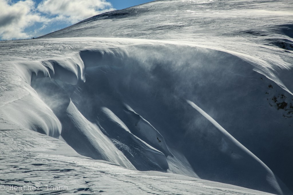
Today the avalanche danger will start off LOW in the Alpine, but could increase to MODERATE later in the evening as 20-30 mph winds combined with new snow will increase the size of wind slabs. Wind slabs up to 8 € are possible today on steep leeward aspects and if triggered could knock you off of your feet. This avalanche problem is unlikely to bury a person, but could cause trauma if triggered above rocky terrain.
LOW avalanche danger exists at Treeline.
LOW danger does not mean NO danger. Triggering a slab up to 2′ thick is unlikely, but is worth considering if riding/sking on steep Northern and Western shaded slopes. Cornices will also be a terrain feature to avoid today.
Yesterday ridgetop winds 20-30mph were observed from the Northeast and will continue throughout the day. Isolated wind slabs up to 8” thick are possible on leeward aspects of ridges and terrain features. Due to the limited amount of snow available for transport these slabs will be small and are unlikely to bury a person. However if triggered in the wrong place it will be possible to take a ride over a cliff or through rocks. Use caution if traveling along ridgetops and avoid hollow sounding snow and pillow-like features on steep complex terrain.
Wind slabs are likely to become thicker later in the evening with snowfall, up to 3″, forecasted for the upper elevations.
It’s been just over a week since a layer of faceted snow was covered by a 2-3′ slab (post St. Patty’s Day storms 3/16 and 3/19) and widespread avalanche activity ensued. We have been talking about this problem extensively and the variable nature of where it exists and where it does not. In short, triggering a persistent slab is becoming more and more unlikely because 1) many slopes have either already avalanched, 2) the facets were blown away before the storm or 3) the slab/weak layer has adjusted.
That said: there is still a remote chance a person could trigger a slab up to 2′ thick that fails in weak faceted snow. Shaded aspects with no surface crust are the most suspect. Safe travel practices are encouraged – expose only one person at a time on a slope and have an escape route planned.
Cornices:
Cornices have been growing over the last few weeks and today’s moderate Eastern ridgetop winds will continue their growth. If traveling near a ridgeline, be aware of cornice formations and give them lots of space. Steady moderate winds could increase the likelihood of cornice fall – thus avoid travel below cornices as well.
Cornices like this one on Seattle Ridge have been getting larger over the last few weeks.
Wet Avalanches:
Overnight temperatures have remained above freezing (F) at mid and lower elevations. Rain will start later this afternoon and small wet loose avalanches on Southern and Eastern aspects below 2000’ are possible, yet should remain a low hazard.
Yesterday skies were mostly clear. Temperatures spiked into the mid 40’s F below 2000′ and reached the mid 20’s F at upper elevations. Ridgetop winds were 20-30 mph. No precipitation was recorded.
Overnight winds remained the same. Temperatures were warm, mid 20’s F along ridgetops and mid 30’s F at lower elevations.
Today moderate ridgetops winds 20-30 mph from the Northeast will continue throughout the day. Temperatures will remain above freezing (F) at sea level and light precipitation is expected to start this afternoon. Up to 3″ of snow could fall this evening in the upper elevations. Expect rain along the coast and rain/snow line could be as high as 2000.’
Rain is expected overnight through tomorrow and is likely to be heaviest tomorrow morning and into the early afternoon. Temperatures will stay warm and rain/snow line is likely to be between 1000′-2000′. Ridgetop winds will remain moderate from East.
Temp Avg (F) | Snow (in) | Water (in) | Snow Depth (in) | |
Center Ridge (1880′) | 35 | 0 | 0 | 54 |
Summit Lake (1400′) | 30 | 0 | 0 | 12 |
Alyeska Mid (1700′) | 36 | 0 | 0 | 31 |
Temp Avg (F) | Wind Dir | Wind Avg (mph) | Wind Gust (mph) | |
Sunburst (3812′) | 25 | ENE | 19 | 48 |
Seattle Ridge (2400′) | 28 | NNW | 20 | 45 |
Date | Region | Location | Observer |
---|---|---|---|
05/22/23 | Turnagain | Avalanche: Tincan | Nick D'Alessio |
05/12/23 | Turnagain | Avalanche: Tincan, Sunburst, Magnum, Cornbiscuit | Heather Thamm |
05/07/23 | Turnagain | Observation: Tincan – Bear Tracks | CNFAIC Staff |
05/05/23 | Turnagain | Observation: Seattle Ridge | AS/ WW Forecaster |
05/02/23 | Turnagain | Observation: Cornbiscuit | Schauer/ Sturgess Forecaster |
05/02/23 | Turnagain | Observation: Seward Hwy Turnagain Pass | Joel Curtis |
04/30/23 | Turnagain | Observation: Magnum | Ayla, Kit Crosby, Barton |
04/29/23 | Turnagain | Observation: Tincan | John Sykes |
04/28/23 | Turnagain | Avalanche: Taylor Pass/Pastoral | Schauer/ Creighton Forecaster |
04/28/23 | Turnagain | Avalanche: Tincan | Andy Moderow |
Status of riding areas across the Chugach NF is managed by the Glacier and Seward Ranger Districts, not avalanche center staff. Riding area information is posted as a public service to our users and updated based on snow depth and snow density to prevent resource damage at trailhead locations. Riding area questions contact: mailroom_r10_chugach@fs.fed.us
Area | Status | Weather & Riding Conditions |
---|---|---|
Glacier District |
Subscribe to Turnagain Pass
Avalanche Forecast by Email
This is a general backcountry avalanche advisory issued for Turnagain Arm with Turnagain Pass as the core advisory area. This advisory does not apply to highways, railroads or operating ski areas.