Turnagain Pass RSS

Archives
ARCHIVED - Forecasts expire after 24 hours.
Issued
Thu, March 26th, 2015 - 7:00AM
Expires
Fri, March 27th, 2015 - 7:00AM
Forecaster
Graham Predeger
Avalanche risk The Bottom Line

The avalanche danger in the backcountry will climb to MODERATE as a spring storm enters the advisory area with a change in weather from the past few days.   Above treeline 8-10 € of new snow coupled with 20-40 mph winds from the East will build wind slabs in the 1-2 foot range.   These will be sensitive to human triggers today, particularly on north and west (leeward) slopes.  

Near treeline, a rain/ snow mix may be enough to initiate wet loose activity or potentially a wet slab avalanche in steep terrain.

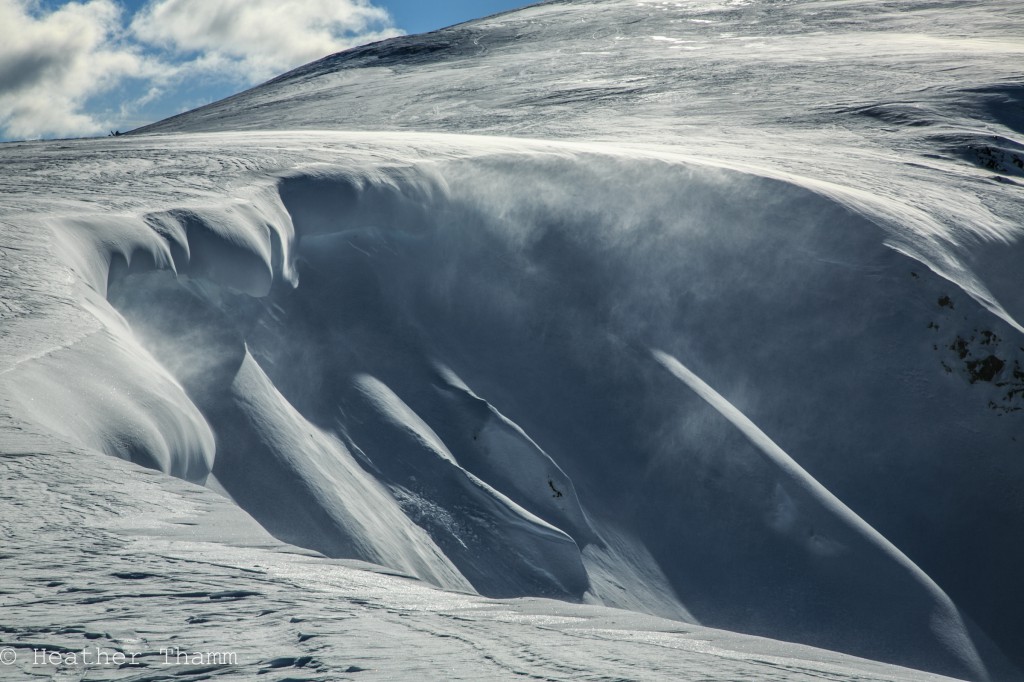
An additional concern to be aware of during this first week of spring comes in the form of growing and weakening cornices.   Simply put; avoid them.

Special Announcements

CNFAIC staff have completed an accident report for the avalanche fatality in Cantwell on March 14th, 2015.  This is Alaska’s second fatal avalanche of the 2014/15 season and the seventh in the US this winter.  Please take a few minutes to read this report and share it with your skiing and riding partners as there is always a lesson to be learned in light of a tragic accident such as this.

Thu, March 26th, 2015
Alpine
Above 2,500'
2 - Moderate
Avalanche risk
Treeline
1,000'-2,500'
2 - Moderate
Avalanche risk
Below Treeline
Below 1,000'
0 - No Rating
Avalanche risk
0 - No Rating
1 - Low
2 - Moderate
3 - Considerable
4 - High
5 - Extreme
Avalanche risk Avalanche risk Avalanche risk Avalanche risk Avalanche risk
Travel Advice Generally safe avalanche conditions. Watch for unstable snow on isolated terrain features. Heightened avalanche conditions on specific terrain features. Evaluate snow and terrain carefully; identify features of concern. Dangerous avalanche conditions. Careful snowpack evaluation, cautious route-finding, and conservative decision-making essential. Very dangerous avalanche conditions. Travel in avalanche terrain not recommended. Extraordinarily dangerous avalanche conditions. Avoid all avalanche terrain.
Likelihood of Avalanches Natural and human-triggered avalanches unlikely. Natural avalanches unlikely; human-triggered avalanches possible. Natural avalanches possible; human-triggered avalanches likely. Natural avalanches likely; human-triggered avalanches very likely. Natural and human-triggered avalanches certain.
Avalanche Size and Distribution Small avalanches in isolated areas or extreme terrain. Small avalanches in specific areas; or large avalanches in isolated areas. Small avalanches in many areas; or large avalanches in specific areas; or very large avalanches in isolated areas. Large avalanches in many areas; or very large avalanches in specific areas. Very large avalanches in many areas.
Avalanche Problem 1
  • Wind Slabs
    Wind Slabs
Wind Slabs
Wind Slab avalanches are the release of a cohesive layer of snow (a slab) formed by the wind. Wind typically transports snow from the upwind sides of terrain features and deposits snow on the downwind side. Wind slabs are often smooth and rounded and sometimes sound hollow, and can range from soft to hard. Wind slabs that form over a persistent weak layer (surface hoar, depth hoar, or near-surface facets) may be termed Persistent Slabs or may develop into Persistent Slabs.
More info at Avalanche.org

With another spring storm moving in from the southeast we can expect wind slabs to be touchy for the next 24 hours, particularly above 2,000’ as moderate easterly winds rake through the advisory area.  This is a direct-action avalanche problem meaning we can expect fresh wind slabs to be sensitive to human triggers during and immediately following this storm.   Expect wind slabs to be in the 12- 24” range and relegated to the new snow accumulating on slick sun crusts  and weak faceted snow.

Red flags such as shooting cracks or whumphing in the snowpack are likely to be present in areas where wind slabs exist and should be interpreted as nothing other than unstable snow!  Best practices today and during this storm will be to avoid convexities and steep rollovers where these fresh wind slabs exist.  This is particularly important if a slope ends in a terrain trap such as a gully or flat bench where avalanche debris can accumulate.

Avalanche Problem 2
  • Wet Loose
    Wet Loose
Wet Loose
Wet Loose avalanches are the release of wet unconsolidated snow or slush. These avalanches typically occur within layers of wet snow near the surface of the snowpack, but they may quickly gouge into lower snowpack layers. Like Loose Dry Avalanches, they start at a point and entrain snow as they move downhill, forming a fan-shaped avalanche. Other names for loose-wet avalanches include point-release avalanches or sluffs. Loose Wet avalanches can trigger slab avalanches that break into deeper snow layers.
More info at Avalanche.org

Temperatures yesterday were very warm for March.  If the rain/ snow line climbs to near 2,000’ today, wet loose avalanches may come in to play.  Wet loose activity or roller balls may initiate a wet slab near treeline elevations as well.  Given the freeze/ thaw activity over the last week, the potential for a wet slab release is low but worth mentioning if temperatures rise and rain on snow becomes a reality.

Seattle ridge as seen from the motorized parking lot looking North.  This photo was taken at 5:30pm and the temperature at 1,000′ was 46 degrees.  

Additional Concern
  • Cornice
    Cornice
Cornice
Cornice Fall is the release of an overhanging mass of snow that forms as the wind moves snow over a sharp terrain feature, such as a ridge, and deposits snow on the downwind (leeward) side. Cornices range in size from small wind drifts of soft snow to large overhangs of hard snow that are 30 feet (10 meters) or taller. They can break off the terrain suddenly and pull back onto the ridge top and catch people by surprise even on the flat ground above the slope. Even small cornices can have enough mass to be destructive and deadly. Cornice Fall can entrain loose surface snow or trigger slab avalanches.
More info at Avalanche.org

Cornices will further ripen with today’s sticky spring-storm.  We haven’t seen these fail naturally in earnest yet but rest assured they are losing strength and drawing closer to that point of failure.  Though beautiful to look at, avoid time spent below a cornice and stay well back from corniced ridges.

Weather
Thu, March 26th, 2015

Yesterday saw the slow approach of a front associated with a low in the northeast Gulf of Alaska.   Skies were partly cloudy and winds moderate to strong at times from the east.   The real outlier was how warm ambient air temperatures were with Center ridge (1880′) topping out at 47 degrees yesterday and low 50’s seen around Portage.

The storm showed up in earnest around 11pm last night with wet snow falling at Turnagain pass (1000′) and snow accumulations in the 2-5 € range this morning.   Today expect a stormy day with the rain/ snow line to be around 1000′.     Up to another .4 € of water (4-5 € of snow) is expected today with ridgetop temperatures in the high 20’s.   Winds will be out of the east 20- 40mph then shifting southeast this evening.

Unsettled weather looks to be in our future through the weekend as another North Pacific low tracks south of Kodiak by Saturday.

PRECIPITATION 24-hour data (6am – 6am)

  Temp Avg (F) Snow (in) Water (in) Snow Depth (in)
Center Ridge (1880′) 37    2 .2   57  
Summit Lake (1400′)  38 0   0   12  
Alyeska Mid (1700′) 38    2 .33   31  

RIDGETOP 24-hour data (6am – 6am)

  Temp Avg (F) Wind Dir Wind Avg (mph) Wind Gust (mph)
Sunburst (3812′)  27  E 28    70
Seattle Ridge (2400′) 30    n/a 16    71
Observations
Recent Observations for Turnagain Pass
Date Region Location
04/23/24 Turnagain Observation: Turnagain Sunny Side
04/21/24 Turnagain Observation: Bertha Creek
04/20/24 Turnagain Avalanche: Spokane Creek
04/16/24 Turnagain Observation: Cornbiscuit
04/15/24 Turnagain Observation: Taylor Pass
04/15/24 Turnagain Observation: Seward Highway – Tern Lake to Portage
04/14/24 Turnagain Observation: Sunburst
04/14/24 Turnagain Observation: Turnagain Pass Snomo
04/13/24 Turnagain Observation: Spokane Creek
04/11/24 Turnagain Observation: Tincan
Riding Areas

The riding areas page has moved. Please click here & update your bookmarks.


Subscribe to Turnagain Pass
Avalanche Forecast by Email

This is a general backcountry avalanche advisory issued for Turnagain Arm with Turnagain Pass as the core advisory area. This advisory does not apply to highways, railroads or operating ski areas.