Turnagain Pass Avalanche Forecast RSS

Archives
ARCHIVED FORECAST - All forecasts expire after 24 hours from the posting date/time.
Issued
Tue, November 27th, 2012 - 7:00AM
Expires
Wed, November 28th, 2012 - 7:00AM
Forecaster
Wendy Wagner
Avalanche risk The Bottom Line

We are issuing advisories 5 days a week through November on Sat, Sun, Tue, Thur and Fri.

The next advisory will be issued Thursday, November 29th.

ANNOUNCEMENTS
A reminder that motorized use areas remain closed due to the thin snow cover. The Forest Service aims to open these areas as soon as possible so once the storms get rolling watch for status updates at the end of this advisory page.
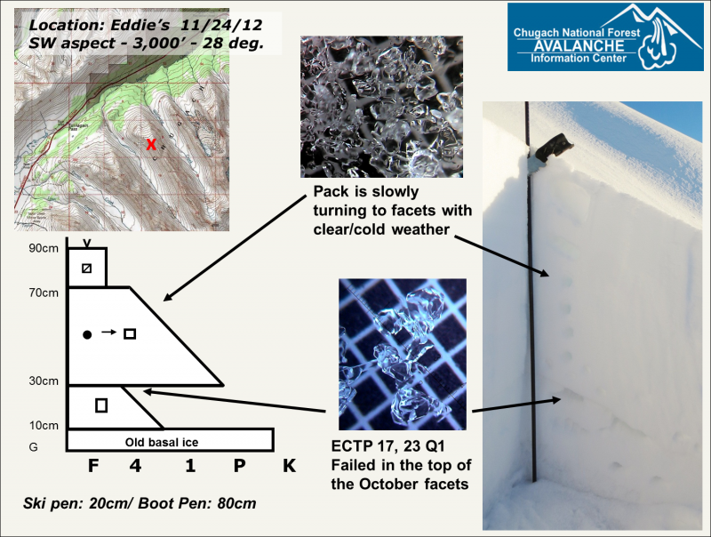
BOTTOM LINE
Above treeline we continue to have a MODERATE avalanche danger for persistent slab avalanches. It remains possible for a person to trigger one of these slabs on the steeper slopes above 3000′ on south, west and northerly aspects. Safer riding conditions can be found where a slab of stiffer snow does not overlie the weak snow from October. Below treeline there is a LOW avalanche danger.

This BOTTOM LINE will also pertain to Wednesday, November 28th

Thanks to our sponsors!
Tue, November 27th, 2012
Alpine
Above 2,500'
Moderate (2)
Avalanche risk
Treeline
1,000'-2,500'
Low (1)
Avalanche risk
Below Treeline
Below 1,000'
Low (1)
Avalanche risk
Alpine
Above 2,500'
Avalanche risk
Moderate (2)
Treeline
1,000'-2,500'
Avalanche risk
Low (1)
Below Treeline
Below 1,000'
Avalanche risk
Low (1)
Danger Scale:
No Rating (0)
Low (1)
Moderate (2)
Considerable (3)
High (4)
Extreme (5)
Avalanche Problem 1
  • Persistent Slabs
    Persistent Slabs
Persistent Slabs
Persistent Slab avalanches are the release of a cohesive layer of snow (a slab) in the middle to upper snowpack, when the bond to an underlying persistent weak layer breaks. Persistent layers include: surface hoar, depth hoar, near-surface facets, or faceted snow. Persistent weak layers can continue to produce avalanches for days, weeks or even months, making them especially dangerous and tricky. As additional snow and wind events build a thicker slab on top of the persistent weak layer, this avalanche problem may develop into a Deep Persistent Slab.
More info at Avalanche.org

There has not been a whole lot of change in the avalanche conditions lately and we have not heard of any avalanche activity the past few days. The pack is becoming weaker and weaker every day under clear and cold weather. Surface conditions consist of surface hoar in most areas and near surface facets below. Very little wind for a while now has kept the recycled powder quite nice. The snow is still mostly supportable to skis and/or a board but once you step off, your boot goes straight to the tundra. Rocks are the biggest hazard where most folks are recreating right now.

That said, the steeper slopes at the upper elevations continue to harbor slabs that have the potential to avalanche to the ground and take someone on a nasty ride. Slopes that are most likely to be triggered are those at the higher elevations in the 40 degree range and unsupported from below. Probing with a pole to feel for stiff snow over hollow feeling snow and watching for collapsing and cracking are good ways to find suspect areas.

This problem is very slowly getting better and for the snow geek here is a pit profile of one such suspect slope HERE. There are a few reasons the pack is taking longer to rot away at the upper elevations. One is the snow is deeper and stiffer than the lower elevations so it simply takes longer. Another is the temperature has remained warmer (upper teens to mid 20’s) compared with the single digit temperatures below treeline, this is creating much lower snowpack temperature gradients at the higher elevations than the large gradients seen at the lower elevations. But the fact remains, the whole pack is well on its way to becoming one big weak layer.

Weather
Tue, November 27th, 2012

Clear skies and light easterly winds prevail once again today. A strong temperature gradient exists this morning with mid 20’s F above treeline and minus single digits below treeline, -10F in Portage (burr). Winds are clam currently and forecast to be around 5mph today from the east. Tomorrow, Wednesday, looks to me more of the same. In fact, it looks that way into the beginning of December:


This is a general backcountry avalanche advisory issued for Turnagain Arm with Turnagain Pass as the core advisory area (this advisory does not apply to highways, railroads, or operating ski areas).  

Kevin will issue the next advisory Thursday morning, November 29th.

Observations
Recent Observations for Turnagain Pass
Date Region Location
05/22/23 Turnagain Avalanche: Tincan
05/12/23 Turnagain Avalanche: Tincan, Sunburst, Magnum, Cornbiscuit
05/07/23 Turnagain Observation: Tincan – Bear Tracks
05/05/23 Turnagain Observation: Seattle Ridge
05/02/23 Turnagain Observation: Cornbiscuit
05/02/23 Turnagain Observation: Seward Hwy Turnagain Pass
04/30/23 Turnagain Observation: Magnum
04/29/23 Turnagain Observation: Tincan
04/28/23 Turnagain Avalanche: Taylor Pass/Pastoral
04/28/23 Turnagain Avalanche: Tincan
Riding Areas
Updated Thu, June 01st, 2023

Status of riding areas across the Chugach NF is managed by the Glacier and Seward Ranger Districts, not avalanche center staff. Riding area information is posted as a public service to our users and updated based on snow depth and snow density to prevent resource damage at trailhead locations. Riding area questions contact: mailroom_r10_chugach@fs.fed.us

Area Status Weather & Riding Conditions
Glacier District
Johnson Pass
Closed
Closed May 15.
Placer River
Closed
Closed May 15.
Skookum Drainage
Closed
Will close to motorized use on April 1, 2023 per the National Forest Plan.
Turnagain Pass
Closed
Will close on June 1.
Twentymile
Closed
Scheduled closure May 1.
Seward District
Carter Lake
Closed
Scheduled closure May 1.
Lost Lake Trail
Closed
Scheduled closure May 1.
Primrose Trail
Closed
Scheduled closure May 1.
Resurrection Pass Trail
Closed
Closed to motorized use for the 2022/23 winter season per Forest Plan. Open next season.
Snug Harbor
Closed
Extended opening until May 15.
South Fork Snow River Corridor
Closed
Scheduled closure May 1.
Summit Lake
Closed
Scheduled closure May 1.

Subscribe to Turnagain Pass
Avalanche Forecast by Email

This is a general backcountry avalanche advisory issued for Turnagain Arm with Turnagain Pass as the core advisory area. This advisory does not apply to highways, railroads or operating ski areas.