Turnagain Pass RSS

Archives
ARCHIVED - Forecasts expire after 24 hours.
Issued
Tue, December 31st, 2019 - 7:00AM
Expires
Wed, January 1st, 2020 - 7:00AM
Forecaster
Ryan Van Luit
Avalanche risk The Bottom Line

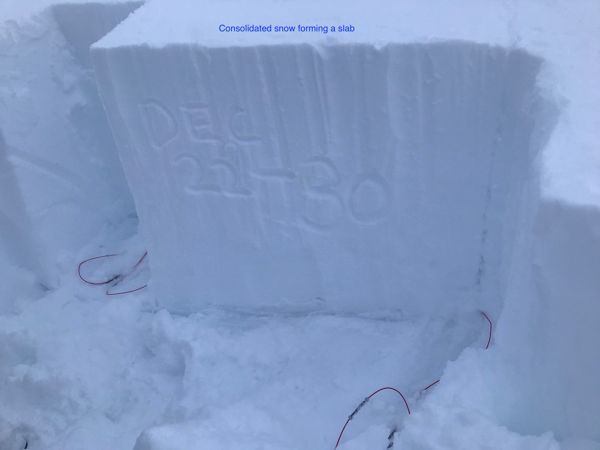
The avalanche danger is CONSIDERABLE above 1000′ today where natural avalanches are likely.  Warmer temperatures and steady winds have created dense slabs 1-3′ thick.  This slab sits atop a weak layer that could be easily triggered.  Wet avalanches below 2,500 are possible with rain expected to fall on snow today. The avalanche conditions warrant very careful terrain selection.  Below 1000′ the danger is MODERATE where an avalanche from above could send debris to sea level.

* Roof avalanches due to rain falling at sea level are likely. Pay attention to children, pets and where you park your car.  Move through these hazard areas swiftly.

Special Announcements

Chugach State Park:  Strong winds are impacting the Western Chugach mountains and Southcentral region-wide. An elevated avalanche hazard should be expected in areas seeing warm and stormy weather.

Tue, December 31st, 2019
Alpine
Above 2,500'
3 - Considerable
Avalanche risk
Treeline
1,000'-2,500'
3 - Considerable
Avalanche risk
Below Treeline
Below 1,000'
2 - Moderate
Avalanche risk
0 - No Rating
1 - Low
2 - Moderate
3 - Considerable
4 - High
5 - Extreme
Avalanche risk Avalanche risk Avalanche risk Avalanche risk Avalanche risk
Travel Advice Generally safe avalanche conditions. Watch for unstable snow on isolated terrain features. Heightened avalanche conditions on specific terrain features. Evaluate snow and terrain carefully; identify features of concern. Dangerous avalanche conditions. Careful snowpack evaluation, cautious route-finding, and conservative decision-making essential. Very dangerous avalanche conditions. Travel in avalanche terrain not recommended. Extraordinarily dangerous avalanche conditions. Avoid all avalanche terrain.
Likelihood of Avalanches Natural and human-triggered avalanches unlikely. Natural avalanches unlikely; human-triggered avalanches possible. Natural avalanches possible; human-triggered avalanches likely. Natural avalanches likely; human-triggered avalanches very likely. Natural and human-triggered avalanches certain.
Avalanche Size and Distribution Small avalanches in isolated areas or extreme terrain. Small avalanches in specific areas; or large avalanches in isolated areas. Small avalanches in many areas; or large avalanches in specific areas; or very large avalanches in isolated areas. Large avalanches in many areas; or very large avalanches in specific areas. Very large avalanches in many areas.
Avalanche Problem 1
  • Storm Slabs
    Storm Slabs
  • Certain
    Very Likely
    Likely
    Possible
    Unlikely
    Likelihood
  • Historic (D4-5)
    Very Large (D3)
    Large (D2)
    Small (D1)
    Size
Storm Slabs
Storm Slab avalanches are the release of a cohesive layer (a slab) of new snow that breaks within new snow or on the old snow surface. Storm-slabs typically last between a few hours and few days (following snowfall). Storm-slabs that form over a persistent weak layer (surface hoar, depth hoar, or near-surface facets) may be termed Persistent Slabs or may develop into Persistent Slabs.

Likelihood of Avalanches
Terms such as "unlikely", "likely", and "certain" are used to define the scale, with the chance of triggering or observing avalanches increasing as we move up the scale. For our purposes, "Unlikely" means that few avalanches could be triggered in avalanche terrain and natural avalanches are not expected. "Certain" means that humans will be able to trigger avalanches on many slopes, and natural avalanches are expected.

Size of Avalanches
Avalanche size is defined by the largest potential avalanche, or expected range of sizes related to the problem in question. Assigned size is a qualitative estimate based on the destructive classification system and requires specialists to estimate the harm avalanches may cause to hypothetical objects located in the avalanche track (AAA 2016, CAA 2014). Under this schema, "Small" avalanches are not large enough to bury humans and are relatively harmless unless they carry people over cliffs or through trees or rocks. Moving up the scale, avalanches become "Large" enough to bury, injure, or kill people. "Very Large" avalanches may bury or destroy vehicles or houses, and "Historic" avalanches are massive events capable of altering the landscape.

Signal Word Size (D scale) Simple Descriptor
Small 1 Unlikely to bury a person
Large 2 Can bury a person
Very Large 3 Can destroy a house
Historic 4 & 5 Can destroy part or all of a village
More info at Avalanche.org

Observers reported widespread whumpfing and shooting cracks yesterday. These are clear indicators that a cohesive slab is forming and our weak layers/s are susceptible to natural and human trigger.  In wind drifted areas, this slab could easily be 3′ thick or more.  On top of this, it’s forecast to rain up to 2500′ by mid day.  Human triggered storm slab and wind slab avalanches are likely, especially in steeper and unsupported terrain. These storm slabs could exist on all aspects.  Test pits are indicating weaknesses at recent storm snow interfaces as well as buried surface hoar from solstice.  Triggering an avalanche at one of these shallower layers could easily step down to trigger instability deeper within the snowpack.  Remain vigilant near convex rollovers, wind loaded areas, and near smaller features with terrain traps.

Cornices:  Wet snow and strong winds have further developed the cornices throughout the region. With relatively warm temperatures cornice failure can become easy to trigger.

65cm thick slab becoming cohesive after warming temperatures


Avalanche Problem 2
  • Wet Slab
    Wet Slab
  • Certain
    Very Likely
    Likely
    Possible
    Unlikely
    Likelihood
  • Historic (D4-5)
    Very Large (D3)
    Large (D2)
    Small (D1)
    Size
Wet Slab
Wet Slab avalanches are the release of a cohesive layer of snow (a slab) that is generally moist or wet when the flow of liquid water weakens the bond between the slab and the surface below (snow or ground). They often occur during prolonged warming events and/or rain-on-snow events. Wet Slabs can be very unpredictable and destructive.

Likelihood of Avalanches
Terms such as "unlikely", "likely", and "certain" are used to define the scale, with the chance of triggering or observing avalanches increasing as we move up the scale. For our purposes, "Unlikely" means that few avalanches could be triggered in avalanche terrain and natural avalanches are not expected. "Certain" means that humans will be able to trigger avalanches on many slopes, and natural avalanches are expected.

Size of Avalanches
Avalanche size is defined by the largest potential avalanche, or expected range of sizes related to the problem in question. Assigned size is a qualitative estimate based on the destructive classification system and requires specialists to estimate the harm avalanches may cause to hypothetical objects located in the avalanche track (AAA 2016, CAA 2014). Under this schema, "Small" avalanches are not large enough to bury humans and are relatively harmless unless they carry people over cliffs or through trees or rocks. Moving up the scale, avalanches become "Large" enough to bury, injure, or kill people. "Very Large" avalanches may bury or destroy vehicles or houses, and "Historic" avalanches are massive events capable of altering the landscape.

Signal Word Size (D scale) Simple Descriptor
Small 1 Unlikely to bury a person
Large 2 Can bury a person
Very Large 3 Can destroy a house
Historic 4 & 5 Can destroy part or all of a village
More info at Avalanche.org

Rain is forecast to fall possibly as high as 2500′  by mid-day.  If enough rain falls we could see wet avalanche activity, especially in steeper terrain.  Remain alert if the snow surface is particularly heavy, or you’re in an area where it’s raining,

Weather
Tue, December 31st, 2019

Yesterday: Cloudy skies and light snow and rain showers. Temperatures in the high 20°Fs at ridgetops and high 30°Fs at sea level.  Easterly winds 10-20 mph with gusts into the 40s. Temperatures increased overnight and rain/snowline was near 1500′.

Today: Cloudy skies today. Temperatures in the low 30°Fs with rain until later this evening when the temperatures drop below freezing and the rain turns to light snow with a chance of accumulation from 3-6″ near 1000′ .  Temperatures will likely range from 40°Fs at sea level to upper 20°Fs at ridgetops. Winds will be from the southeast at 30 to 40 mph, gusts to 60mph.

Tomorrow: The current storm will move out with mostly cloudy skies and light snow showers.  Temperatures will drop rapidly to near 20°F, low near 5°F and winds will be out of the southeast at 5 to 10 mph.

PRECIPITATION 24-hour data (6am – 6am)

Temp Avg (F) Snow (in) Water (in) Snow Depth (in)
Center Ridge (1880′) 33 0 0 39
Summit Lake (1400′) 31 0 0.1 12
Alyeska Mid (1700′) 32 trace 0.1 38

RIDGETOP 24-hour data (6am – 6am)

Temp Avg (F) Wind Dir Wind Avg (mph) Wind Gust (mph)
Sunburst (3812′) 24 ENE 17 44
Seattle Ridge (2400′) 27 N/A N/A N/A
Observations
Recent Observations for Turnagain Pass
Date Region Location
04/16/24 Turnagain Observation: Cornbiscuit
04/15/24 Turnagain Observation: Taylor Pass
04/15/24 Turnagain Observation: Seward Highway – Tern Lake to Portage
04/14/24 Turnagain Observation: Sunburst
04/14/24 Turnagain Observation: Turnagain Pass Snomo
04/13/24 Turnagain Observation: Spokane Creek
04/11/24 Turnagain Observation: Tincan
04/10/24 Turnagain Avalanche: Seattle Ridge
04/10/24 Turnagain Observation: Cornbiscuit South Face
04/10/24 Turnagain Avalanche: Tincan
Riding Areas

The riding areas page has moved. Please click here & update your bookmarks.


Subscribe to Turnagain Pass
Avalanche Forecast by Email

This is a general backcountry avalanche advisory issued for Turnagain Arm with Turnagain Pass as the core advisory area. This advisory does not apply to highways, railroads or operating ski areas.