Turnagain Pass RSS

Archives
ARCHIVED - Forecasts expire after 24 hours.
Issued
Thu, December 30th, 2021 - 7:00AM
Expires
Fri, December 31st, 2021 - 7:00AM
Forecaster
John Sykes
Avalanche risk The Bottom Line

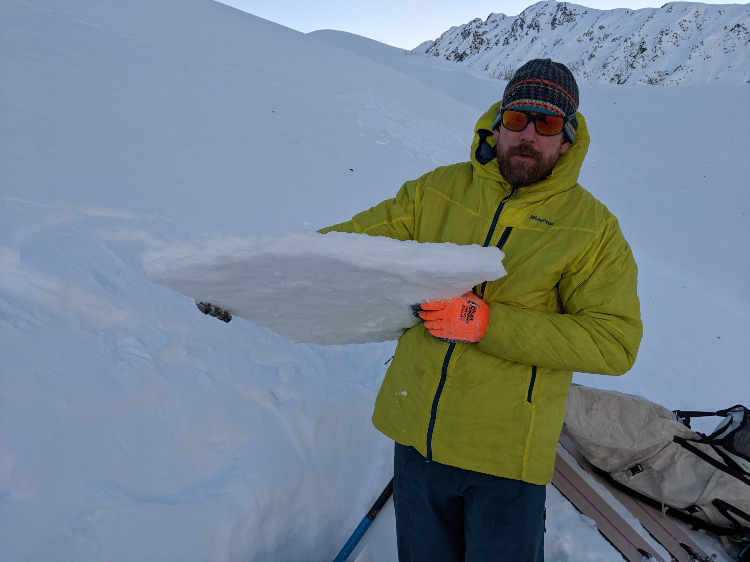
The avalanche danger is LOW today at all elevations. In steep terrain at higher elevations where we saw strong winds yesterday a person could trigger an isolated wind slab up to 1′ deep. The warm and wet weather from earlier this week has created a widespread melt/rain crust on the surface. This crust makes for challenging travel conditions but it also added strength to the snowpack and makes it unlikely to trigger a large avalanche on a layer of weak sugary facets 2-5+’ deep. Your chances of triggering an avalanche on this deeper layer are greater in areas with a shallow overall snowpack, like along the southern portion of the forecast zone.

SUMMIT LAKE – This area has a much shallower snowpack than our forecast zone and has seen more recent activity on the buried facets. Now that the moisture from earlier in the week has frozen we expect that the snowpack has gained a significant amount of strength, but recommend careful evaluation of the snowpack since it is so different from our forecast zone.

Special Announcements

The Friends of the Chugach Avalanche Center’s ‘Member Appreciation Giveaway‘ just got better. For anyone donating $100 or more by January 10th, you are entered to win a FREE stand-by heli-skiing day with Chugach Powder Guides. This is on top of the airbag pack and skis donated by AMH and SkiAK. Get your membership today – more details HERE. A big thank you to all our supporters!!

Thu, December 30th, 2021
Alpine
Above 2,500'
1 - Low
Avalanche risk
Treeline
1,000'-2,500'
1 - Low
Avalanche risk
Below Treeline
Below 1,000'
1 - Low
Avalanche risk
0 - No Rating
1 - Low
2 - Moderate
3 - Considerable
4 - High
5 - Extreme
Avalanche risk Avalanche risk Avalanche risk Avalanche risk Avalanche risk
Travel Advice Generally safe avalanche conditions. Watch for unstable snow on isolated terrain features. Heightened avalanche conditions on specific terrain features. Evaluate snow and terrain carefully; identify features of concern. Dangerous avalanche conditions. Careful snowpack evaluation, cautious route-finding, and conservative decision-making essential. Very dangerous avalanche conditions. Travel in avalanche terrain not recommended. Extraordinarily dangerous avalanche conditions. Avoid all avalanche terrain.
Likelihood of Avalanches Natural and human-triggered avalanches unlikely. Natural avalanches unlikely; human-triggered avalanches possible. Natural avalanches possible; human-triggered avalanches likely. Natural avalanches likely; human-triggered avalanches very likely. Natural and human-triggered avalanches certain.
Avalanche Size and Distribution Small avalanches in isolated areas or extreme terrain. Small avalanches in specific areas; or large avalanches in isolated areas. Small avalanches in many areas; or large avalanches in specific areas; or very large avalanches in isolated areas. Large avalanches in many areas; or very large avalanches in specific areas. Very large avalanches in many areas.
Avalanche Problem 1
  • Normal Caution
    Normal Caution
Normal Caution
Normal Caution means triggering an avalanche is unlikely but not impossible.
More info at Avalanche.org

A beautiful day is on tap with clear skies, temperatures in the teens to twenties, and light winds. Unfortunately, the warm temperatures and rain earlier this week have created a variable melt/rain crust on the surface throughout the forecast zone. The crust makes skiing and riding conditions challenging, especially at lower elevations. Below 1500′ yesterday  we found a thin breakable crust over soft snow combined with marginal snow cover over alders. At higher elevations and in areas that had been exposed to strong winds from late last week the crust is supportable and travel conditions are a bit easier. The travel conditions are likely the biggest hazard of heading into the backcountry today, but remember that low danger does not mean no danger.

Strong winds at higher elevations yesterday were transporting what little snow was still available into fresh wind slabs. Since most of the snow surface is covered in shiny rain crust the fresh wind slabs stand out like a sore thumb, with a more matte appearance from very fine wind transported snow grains. On the few test rolls we found yesterday these wind slabs were fairly stubborn, but in steep terrain at higher elevations it will be possible to trigger a wind slab up to 1′ deep.

The warm temperatures also appear to have reactivated some of the glide cracks in the area (e.g. Seattle ridge) so be on the lookout for fresh glide activity. Identifying active versus inactive glide cracks can be tricky but you can look for visible dark ground surface in the cracks as an indication of recent activity. This is harder to do in areas with a thinner snowpack where older glide cracks have not been filled in as much, like on the southern end of the forecast area. If in doubt try to avoid spending time underneath these unpredictable hazards.

Melt/rain crust from 2000′ on Lipps. This was the most common snow surface we found yesterday and it provided relatively consistent supportable ski conditions. Photo 12.29.21

In some areas the melt/rain layers penetrated deeper into the snowpack creating multiple layers of melt freeze within the upper snowpack. Photo 12.29.21

Where we found fresh wind deposited snow we were able to get some short shooting cracks. Photo 12.29.21


Additional Concern
  • Deep Persistent Slabs
    Deep Persistent Slabs
Deep Persistent Slabs
Deep Persistent Slab avalanches are the release of a thick cohesive layer of hard snow (a slab), when the bond breaks between the slab and an underlying persistent weak layer deep in the snowpack. The most common persistent weak layers involved in deep, persistent slabs are depth hoar or facets surrounding a deeply buried crust. Deep Persistent Slabs are typically hard to trigger, are very destructive and dangerous due to the large mass of snow involved, and can persist for months once developed. They are often triggered from areas where the snow is shallow and weak, and are particularly difficult to forecast for and manage.
More info at Avalanche.org

It has been over a month since we started talking about a weak layer of buried facets and it is now very unlikely for a person to trigger an avalanche 2-5+’ deep on this layer, but not impossible. In areas with a thinner overall snowpack, such as the southern end of the forecast area near Lynx Creek, Silvertip Drainage, and Johnson Pass, there is a higher likelihood because it is easier for the weight of a skier or rider to penetrate into the weak layer. The same is true for thin spots in the snowpack like near rocks or partially buried trees. One benefit of the melt/rain crust is that it should make triggering a deep persistent avalanche even more difficult. The amount of strength the crust added to the upper snowpack depends on it’s thickness. Lower elevation areas where there is a very thin crust over dry snow will have a gained less strength. We hope that the refreeze after a few days of warm and wet weather has put this weak layer to bed, but it is still on our radar due to the high consequences of triggering a deep persistent avalanche.

Weather
Thu, December 30th, 2021

Yesterday: Clear skies with warms temps ranging from the twenties to low thirties. Winds were strong along ridgelines with gusts into the thirties yesterday morning. At lower elevations winds were moderate but still enough to transport some snow.

Today: Winds are currently still blowing out of the NW and gusting to 20 along ridgelines but they should die down by mid day, before switching directions to the S this evening ahead of a wave of precipitation. Skies should remain clear through the daylight hours before clouds and snow move into the area around 8 pm.

Tomorrow: Snowfall overnight and into the afternoon tomorrow, totaling 1-4″. Moderate winds out of the SE in the teens during the snowfall. Temperatures should remain in the teens to twenties with snowfall expected down to sea level. A period of light winds out of the NW and very cold temperatures should follow this short pulse of snow and persist through the weekend and into early next week.

PRECIPITATION 24-hour data (6am – 6am)

Temp Avg (F) Snow (in) Water (in) Snow Depth (in)
Center Ridge (1880′) 30 0 0 65
Summit Lake (1400′) 22 0 0.1 21
Alyeska Mid (1700′) 31 0 0 38

RIDGETOP 24-hour data (6am – 6am)

Temp Avg (F) Wind Dir Wind Avg (mph) Wind Gust (mph)
Sunburst (3812′) 20 NW 7 36
Seattle Ridge (2400′) 26 NW 10 31
Observations
Recent Observations for Turnagain Pass
Date Region Location
04/23/24 Turnagain Observation: Turnagain Sunny Side
04/21/24 Turnagain Observation: Bertha Creek
04/20/24 Turnagain Avalanche: Spokane Creek
04/16/24 Turnagain Observation: Cornbiscuit
04/15/24 Turnagain Observation: Taylor Pass
04/15/24 Turnagain Observation: Seward Highway – Tern Lake to Portage
04/14/24 Turnagain Observation: Sunburst
04/14/24 Turnagain Observation: Turnagain Pass Snomo
04/13/24 Turnagain Observation: Spokane Creek
04/11/24 Turnagain Observation: Tincan
Riding Areas

The riding areas page has moved. Please click here & update your bookmarks.


Subscribe to Turnagain Pass
Avalanche Forecast by Email

This is a general backcountry avalanche advisory issued for Turnagain Arm with Turnagain Pass as the core advisory area. This advisory does not apply to highways, railroads or operating ski areas.