Turnagain Pass RSS

Archives
ARCHIVED - Forecasts expire after 24 hours.
Issued
Fri, December 23rd, 2022 - 7:00AM
Expires
Sat, December 24th, 2022 - 7:00AM
Forecaster
Andrew Schauer
Avalanche risk The Bottom Line

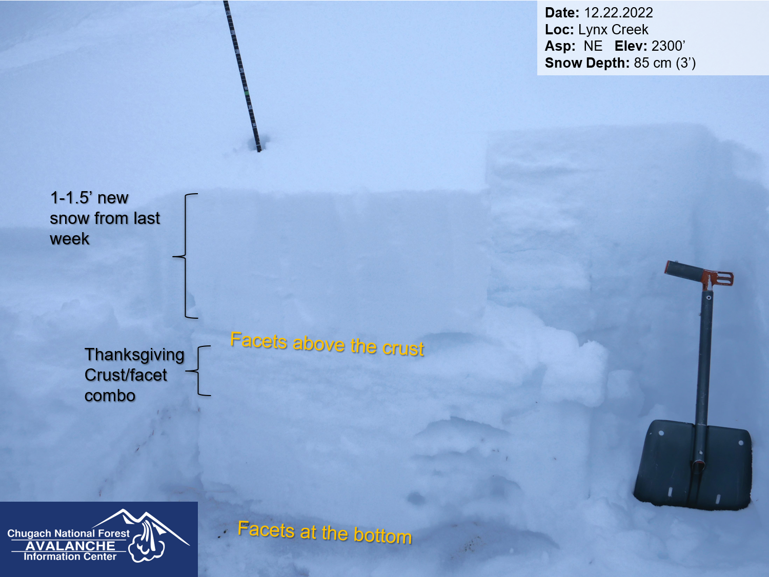
The avalanche danger is MODERATE above 1000′. It is possible for a person to trigger a large avalanche 2-4′ deep on weak, faceted snow surrounding the crust that was buried just before Thanksgiving. The areas with the most concerning snowpack are the mountains around Girdwood and towards the south end of Turnagain Pass. The danger is LOW below 1000′.

LOST LAKE/SEWARD: The mountains in the Seward area will see stronger winds than the core advisory area today, making human-triggered wind slab avalanches a concern.

Special Announcements

Chugach State Park:  We are still seeing signs of an unstable snowpack in CSP. Most recently, this was a large avalanche near Eagle River on Wednesday. You can find more info on that avalanche and other recent observations in or Public Observations Page for that zone.

Become a Member in December! If you haven’t done so already, please consider becoming a member of our non-profit Friends group. Memberships start at just $20, and every member who joins or renews will be entered to win one of the fabulous prizes from our sponsors. This could be that Holiday gift idea you’ve been waiting for! Click here for more info.

Fri, December 23rd, 2022
Alpine
Above 2,500'
2 - Moderate
Avalanche risk
Treeline
1,000'-2,500'
2 - Moderate
Avalanche risk
Below Treeline
Below 1,000'
1 - Low
Avalanche risk
0 - No Rating
1 - Low
2 - Moderate
3 - Considerable
4 - High
5 - Extreme
Avalanche risk Avalanche risk Avalanche risk Avalanche risk Avalanche risk
Travel Advice Generally safe avalanche conditions. Watch for unstable snow on isolated terrain features. Heightened avalanche conditions on specific terrain features. Evaluate snow and terrain carefully; identify features of concern. Dangerous avalanche conditions. Careful snowpack evaluation, cautious route-finding, and conservative decision-making essential. Very dangerous avalanche conditions. Travel in avalanche terrain not recommended. Extraordinarily dangerous avalanche conditions. Avoid all avalanche terrain.
Likelihood of Avalanches Natural and human-triggered avalanches unlikely. Natural avalanches unlikely; human-triggered avalanches possible. Natural avalanches possible; human-triggered avalanches likely. Natural avalanches likely; human-triggered avalanches very likely. Natural and human-triggered avalanches certain.
Avalanche Size and Distribution Small avalanches in isolated areas or extreme terrain. Small avalanches in specific areas; or large avalanches in isolated areas. Small avalanches in many areas; or large avalanches in specific areas; or very large avalanches in isolated areas. Large avalanches in many areas; or very large avalanches in specific areas. Very large avalanches in many areas.
Recent Avalanches

The last reported avalanche activity in our forecast zone was during and immediately following the most recent storm 7 days ago.

Avalanche Problem 1
  • Persistent Slabs
    Persistent Slabs
  • Aspect/Elevation
  • Certain
    Very Likely
    Likely
    Possible
    Unlikely
    Likelihood
  • Historic (D4-5)
    Very Large (D3)
    Large (D2)
    Small (D1)
    Size
Persistent Slabs
Persistent Slab avalanches are the release of a cohesive layer of snow (a slab) in the middle to upper snowpack, when the bond to an underlying persistent weak layer breaks. Persistent layers include: surface hoar, depth hoar, near-surface facets, or faceted snow. Persistent weak layers can continue to produce avalanches for days, weeks or even months, making them especially dangerous and tricky. As additional snow and wind events build a thicker slab on top of the persistent weak layer, this avalanche problem may develop into a Deep Persistent Slab.

Aspect/Elevation of the Avalanche Problem
Specialists develop a graphic representation of the potential distribution of a particular avalanche problem across the topography. This aspect/elevation rose is used to indicate where the particular avalanche problem is thought to exist on all elevation aspects. Areas where the avalanche problem is thought to exist are colored grey, and it is less likely to be encountered in areas colored white.

Likelihood of Avalanches
Terms such as "unlikely", "likely", and "certain" are used to define the scale, with the chance of triggering or observing avalanches increasing as we move up the scale. For our purposes, "Unlikely" means that few avalanches could be triggered in avalanche terrain and natural avalanches are not expected. "Certain" means that humans will be able to trigger avalanches on many slopes, and natural avalanches are expected.

Size of Avalanches
Avalanche size is defined by the largest potential avalanche, or expected range of sizes related to the problem in question. Assigned size is a qualitative estimate based on the destructive classification system and requires specialists to estimate the harm avalanches may cause to hypothetical objects located in the avalanche track (AAA 2016, CAA 2014). Under this schema, "Small" avalanches are not large enough to bury humans and are relatively harmless unless they carry people over cliffs or through trees or rocks. Moving up the scale, avalanches become "Large" enough to bury, injure, or kill people. "Very Large" avalanches may bury or destroy vehicles or houses, and "Historic" avalanches are massive events capable of altering the landscape.

Signal Word Size (D scale) Simple Descriptor
Small 1 Unlikely to bury a person
Large 2 Can bury a person
Very Large 3 Can destroy a house
Historic 4 & 5 Can destroy part or all of a village
More info at Avalanche.org

It is looking like our advisory area should be sheltered from the strong northerly winds that are expected to howl through most of southcentral Alaska today. Although there may still be isolated reactive pockets of wind loaded snow in the alpine that formed over the past two days, our main concern is the possibility of triggering a large avalanche 2-4′ deep on weak, faceted snow associated with the crust that was buried just before Thanksgiving. Triggering an avalanche on this layer is becoming less likely without a significant loading event, but the poor structure is still giving us cause for concern. We’ve noticed a pattern of a weaker snowpack near Girdwood and towards the south end of Turnagain Pass (more details in our observations from Crow Creek, Cornbiscuit and Lynx Creek), but we are still seeing occasional warning signs on the north end of the pass as well (details in this observation from Eddie’s).

Careful terrain management is key for persistent slab avalanche problems like this. These avalanches can propagate over wide distances, and may be triggered remotely from below or above steeper terrain. They will occasionally give you warning signs like collapsing, but as this layer becomes more stubborn these warning signs will continue to become less likely. It is really hard to figure out exactly which slopes will avalanche and which ones won’t with a problem like this. Since we know the weak layer exists through most of our advisory area, the best way to avoid the problem is to stick to smaller, low-angle terrain. This includes avoiding traveling below steep slopes.

That layer of facets on top of the Thanksgiving crust is the main concern for now. It is becoming more stubborn without a new load of snow on top, but it remains possible to trigger a big avalanche. This snowpack in Lynx Creek is thinner and more problematic than the heart of Turnagain Pass. 12.22.2022

Click Here to view the video below if it doesn’t load in your browser.

Weather
Fri, December 23rd, 2022

Yesterday: Skies were mostly cloudy, with some clouds breaking up in the afternoon. High temperatures were in the upper teens to upper 20’s F, dropping through the night to the single digits to low teens F. Winds were blwoing 10-20 mph out of the ENE in the morning, calming down to around 5 mph by mid day. We got a trace of snow in the morning before sunrise.

Today: It’s looking like our advisory area will be one of the few places in Southcentral not impacted by the strong northerly winds today, with sustained speeds expected to stay light at around 5 mph out of the east . Temperatures are expected to continue to fall through the day, getting down to the single digits below 0 F tonight. Skies should be partly to mostly cloudy with no precipitation expected today.

Tomorrow: This cold spell should be short-lived, with temperatures trying to climb back to the low teens F by the end of the day tomorrow and into the low 20’s F tomorrow night. Winds will be light out of the northeast with mostly cloudy skies and no precipitation expected. The next round of snow should arrive later in the day or early evening on Christmas, and as of now it is looking like we could see up to a foot of snow by Tuesday.

PRECIPITATION 24-hour data (6am – 6am)

Temp Avg (F) Snow (in) Water (in) Snow Depth (in)
Center Ridge (1880′) 23 0 0 39
Summit Lake (1400′) 17 0 0 N/A
Alyeska Mid (1700′) 22 0 0 41
Bear Valley – Portage (132′) 17 0 0

RIDGETOP 24-hour data (6am – 6am)

Temp Avg (F) Wind Dir Wind Avg (mph) Wind Gust (mph)
Sunburst (3812′) 16 NE 10 29
Seattle Ridge (2400′) 19 ESE 5 18
Observations
Recent Observations for Turnagain Pass
Date Region Location
04/16/24 Turnagain Observation: Cornbiscuit
04/15/24 Turnagain Observation: Taylor Pass
04/15/24 Turnagain Observation: Seward Highway – Tern Lake to Portage
04/14/24 Turnagain Observation: Sunburst
04/14/24 Turnagain Observation: Turnagain Pass Snomo
04/13/24 Turnagain Observation: Spokane Creek
04/11/24 Turnagain Observation: Tincan
04/10/24 Turnagain Avalanche: Seattle Ridge
04/10/24 Turnagain Observation: Cornbiscuit South Face
04/10/24 Turnagain Avalanche: Tincan
Riding Areas

The riding areas page has moved. Please click here & update your bookmarks.


Subscribe to Turnagain Pass
Avalanche Forecast by Email

This is a general backcountry avalanche advisory issued for Turnagain Arm with Turnagain Pass as the core advisory area. This advisory does not apply to highways, railroads or operating ski areas.