Turnagain Pass Avalanche Forecast
|
![]() ![]() |
![]() |
High Avalanche Danger
Travel in avalanche terrain is not recommended. Avoid being on or beneath all steep slopes.
|
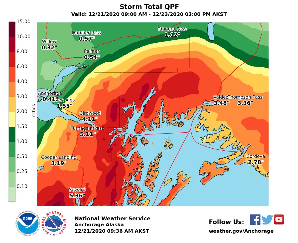
The avalanche danger is HIGH today due to heavy snowfall, rain, and strong winds. Large natural avalanches are likely, human triggered avalanches are very likely, and travel in avalanche terrain is not recommended. With heavy snowfall in the upper elevations and rain to 1700′ we expect to see a mix of dry and wet avalanches, and they could make it down to lower elevation runout zones.
The National Weather Service has issued a High Wind Warning and a Blizzard Warning, noting that ‘Travel could be nearly impossible’ during this storm.
*Roof Avalanches: Warming temperatures and rain could cause roofs to begin to shed their snow. Pay special attention to children, pets and where you park your car.
Member Gear Giveaway: To show appreciation for current members and new members that sign up by January 15, the Friends of the CNFAIC will give away three pairs of skis in a drawing on January 16. Visit our website’s Sponsors & Members page and sign up. For as little as $20 your name will be added to the members list, and you’ll be eligible for the ski drawing! Thanks to Ski AK for donating the skis, and to all of you for supporting your local avalanche center.
Signal Word | Size (D scale) | Simple Descriptor |
Small | 1 | Unlikely to bury a person |
Large | 2 | Can bury a person |
Very Large | 3 | Can destroy a house |
Historic | 4 & 5 | Can destroy part or all of a village |
The weather has gone into overdrive, and we are expecting a lot of avalanche activity today. With heavy snowfall, strong winds, and the rain level creeping up higher through the day, we are anticipating large natural avalanches anywhere from 3-6′ deep, and human-triggered avalanches will be very likely. Ridgetop winds have been blowing 49 to 66 mph since 1:00 this morning, with gusts as high as 104 mph, and the strongest period is expected to continue through the middle of the day. By the time this system passes tomorrow, we could see over 4′ of snow in higher elevation start zones, equaling 4-5″ snow water equivalent (SWE). Temperatures will continue to rise through the day, bringing the rain level as high as 1700′, with as much as 4″ rain on snow at lower elevations below 1000′ before temperatures cool down early tomorrow morning. As heavy snowfall and strong winds will be loading up start zones, rain will be increasing the likelihood of wet avalanches at lower elevations. With all of this active weather, we are anticipating large avalanches that could run far into lower elevation runout zones.
Gusts have reached 104 mph at Sunburst this morning.
NWS graphic showing predicted water content for this storm- over 5″ water at Turnagain Pass!
While we will likely see some impressive avalanches failing within the new snow, there is also the smaller possibility of deeper weak layers in the snowpack failing under the weight of all of this new snow (and rain), which could make for some really, really big avalanches. These weak layers have gained strength, and they have not been reactive in over two weeks. But 4” of SWE in less than 24 hours will sure be a good test to see just how strong they have become. The weather is wild, but that actually makes the avalanche situation quite simple. Today, avalanche conditions will be very dangerous, and travel in avalanche terrain is not recommended.
Glide Avalanches: As if we didn’t already have enough action, we saw our first reported glide avalanche of the season yesterday on Gilpatrick Mountain in the Summit Lake area. This is going to be another issue we will be keeping an eye on as the dust settles from this storm.
Yesterday: After a calm morning, ridgetop winds started picking up at noon, blowing 15-20 mph with gusts into the 30s out of the east. Temperatures climbed from the mid-teens to the low 30’s F at upper elevations, reaching the high 30’s F and even 40 F at lower elevations. Light flurries moved in later in the afternoon.
Today: Easterly winds continued to pick up overnight, blowing 49 – 66 mph since 1:00 this morning with gusts as high as 104 mph. The strongest period of winds is expected to continue through late this morning. We are anticipating up to 4′ of snow at upper elevations, equaling 4″ water. Rain level is expected to creep up to 1700′, and we could see as much as 4″ of rain on snow at lower elevations. High elevation temperatures will reach the low 30’s F this evening, and lower elevations could see temperatures as high as 40 F.
Tomorrow: Snowfall will taper off tomorrow morning, with winds shifting to the south/southwest and dropping to 15-30 mph. Temperatures are expected to be in the mid- to upper 20’s F, and skies may start to clear later tomorrow afternoon and early tomorrow evening.
PRECIPITATION 24-hour data (6am – 6am)
Temp Avg (F) | Snow (in) | Water (in) | Snow Depth (in) | |
---|---|---|---|---|
Center Ridge (1880′) | 28 | 4 | 0.6 | 63 |
Summit Lake (1400′) | 27 | 3 | 0.3 | 29 |
Alyeska Mid (1700′) | 26 | 6 | 0.5 | 64 |
RIDGETOP 24-hour data (6am – 6am)
Temp Avg (F) | Wind Dir | Wind Avg (mph) | Wind Gust (mph) | |
---|---|---|---|---|
Sunburst (3812′) | 18 | ENE | 30 | 104 |
Seattle Ridge (2400′) | 20 | SE | 18 | 51 |
Date | Region | Location | Observer |
---|---|---|---|
05/22/23 | Turnagain | Avalanche: Tincan | Nick D'Alessio |
05/12/23 | Turnagain | Avalanche: Tincan, Sunburst, Magnum, Cornbiscuit | Heather Thamm |
05/07/23 | Turnagain | Observation: Tincan – Bear Tracks | CNFAIC Staff |
05/05/23 | Turnagain | Observation: Seattle Ridge | AS/ WW Forecaster |
05/02/23 | Turnagain | Observation: Cornbiscuit | Schauer/ Sturgess Forecaster |
05/02/23 | Turnagain | Observation: Seward Hwy Turnagain Pass | Joel Curtis |
04/30/23 | Turnagain | Observation: Magnum | Ayla, Kit Crosby, Barton |
04/29/23 | Turnagain | Observation: Tincan | John Sykes |
04/28/23 | Turnagain | Avalanche: Taylor Pass/Pastoral | Schauer/ Creighton Forecaster |
04/28/23 | Turnagain | Avalanche: Tincan | Andy Moderow |
Status of riding areas across the Chugach NF is managed by the Glacier and Seward Ranger Districts, not avalanche center staff. Riding area information is posted as a public service to our users and updated based on snow depth and snow density to prevent resource damage at trailhead locations. Riding area questions contact: mailroom_r10_chugach@fs.fed.us
Area | Status | Weather & Riding Conditions |
---|---|---|
Glacier District |
Subscribe to Turnagain Pass
Avalanche Forecast by Email
This is a general backcountry avalanche advisory issued for Turnagain Arm with Turnagain Pass as the core advisory area. This advisory does not apply to highways, railroads or operating ski areas.