Turnagain Pass RSS

Archives
ARCHIVED - Forecasts expire after 24 hours.
Issued
Sat, December 21st, 2019 - 7:00AM
Expires
Sun, December 22nd, 2019 - 7:00AM
Forecaster
Wendy Wagner
Avalanche risk The Bottom Line

A MODERATE avalanche danger exists in the high Alpine (above 3,000′) and in the periphery of our forecast zone, such as Crow Pass and the far southern end of Turnagain Pass extending to Summit Lake. Although trending to unlikely, a chance may still remain for a person to trigger a large avalanche breaking near the ground in these higher and remote zones.

A LOW avalanche danger exists in the majority of terrain at Turnagain Pass. Watch for lingering wind slabs in very steep terrain, cornice falls along ridgelines and avoid being under glide cracks.

Sat, December 21st, 2019
Alpine
Above 2,500'
2 - Moderate
Avalanche risk
Treeline
1,000'-2,500'
1 - Low
Avalanche risk
Below Treeline
Below 1,000'
0 - No Rating
Avalanche risk
0 - No Rating
1 - Low
2 - Moderate
3 - Considerable
4 - High
5 - Extreme
Avalanche risk Avalanche risk Avalanche risk Avalanche risk Avalanche risk
Travel Advice Generally safe avalanche conditions. Watch for unstable snow on isolated terrain features. Heightened avalanche conditions on specific terrain features. Evaluate snow and terrain carefully; identify features of concern. Dangerous avalanche conditions. Careful snowpack evaluation, cautious route-finding, and conservative decision-making essential. Very dangerous avalanche conditions. Travel in avalanche terrain not recommended. Extraordinarily dangerous avalanche conditions. Avoid all avalanche terrain.
Likelihood of Avalanches Natural and human-triggered avalanches unlikely. Natural avalanches unlikely; human-triggered avalanches possible. Natural avalanches possible; human-triggered avalanches likely. Natural avalanches likely; human-triggered avalanches very likely. Natural and human-triggered avalanches certain.
Avalanche Size and Distribution Small avalanches in isolated areas or extreme terrain. Small avalanches in specific areas; or large avalanches in isolated areas. Small avalanches in many areas; or large avalanches in specific areas; or very large avalanches in isolated areas. Large avalanches in many areas; or very large avalanches in specific areas. Very large avalanches in many areas.
Avalanche Problem 1
  • Persistent Slabs
    Persistent Slabs
  • Certain
    Very Likely
    Likely
    Possible
    Unlikely
    Likelihood
  • Historic (D4-5)
    Very Large (D3)
    Large (D2)
    Small (D1)
    Size
Persistent Slabs
Persistent Slab avalanches are the release of a cohesive layer of snow (a slab) in the middle to upper snowpack, when the bond to an underlying persistent weak layer breaks. Persistent layers include: surface hoar, depth hoar, near-surface facets, or faceted snow. Persistent weak layers can continue to produce avalanches for days, weeks or even months, making them especially dangerous and tricky. As additional snow and wind events build a thicker slab on top of the persistent weak layer, this avalanche problem may develop into a Deep Persistent Slab.

Likelihood of Avalanches
Terms such as "unlikely", "likely", and "certain" are used to define the scale, with the chance of triggering or observing avalanches increasing as we move up the scale. For our purposes, "Unlikely" means that few avalanches could be triggered in avalanche terrain and natural avalanches are not expected. "Certain" means that humans will be able to trigger avalanches on many slopes, and natural avalanches are expected.

Size of Avalanches
Avalanche size is defined by the largest potential avalanche, or expected range of sizes related to the problem in question. Assigned size is a qualitative estimate based on the destructive classification system and requires specialists to estimate the harm avalanches may cause to hypothetical objects located in the avalanche track (AAA 2016, CAA 2014). Under this schema, "Small" avalanches are not large enough to bury humans and are relatively harmless unless they carry people over cliffs or through trees or rocks. Moving up the scale, avalanches become "Large" enough to bury, injure, or kill people. "Very Large" avalanches may bury or destroy vehicles or houses, and "Historic" avalanches are massive events capable of altering the landscape.

Signal Word Size (D scale) Simple Descriptor
Small 1 Unlikely to bury a person
Large 2 Can bury a person
Very Large 3 Can destroy a house
Historic 4 & 5 Can destroy part or all of a village
More info at Avalanche.org

The dark days…. are about to turn the corner. At 7:20pm today, the northern hemisphere will stop tilting away from the sun and back toward it. Happy Solstice everyone!

For this short day out in the mountains, triggering an avalanche at 3,000′ and below is unlikely and trending to unlikely above this. Despite ‘normal caution’, LOW danger avalanche problems stated below, we do have some information on a weak layer of snow sitting near the base of the snowpack in the high Alpine. This layer we are calling the Veteran’s Day Facets and it is sitting on a hard crust. Limited data gives us much uncertainty as to how reactive the layer is throughout the region. It is buried anywhere from 1 – 6+ feet deep due to the extensive wind effect during the early to mid-Dec storm cycles. This presents us with a lingering concern that a person could trigger a larger avalanche at the high elevations above 3,000′. The mostly likely scenario for triggering would be hitting a thin spot in the snowpack or near a rock poking through that initiates failure in the weak layer. Concern is greater where the overall snowpack is shallower- towards the southern end of Turnagain Pass, in Summit Lake and in the Crow Pass terrain just north of Girdwood.

NORMAL CAUTION avalanche concerns:

Lingering wind slabs:  For anyone hitting steep chutes, spines or slopes today, watch for lingering older wind slabs that may not be well bonded with the snow underneath. Even a small wind slab can cause problems by knocking a person off their feet in steep rocky terrain.

Cornice falls:  As always, give cornices a wide berth if traveling along ridgelines and limit exposure under them if traveling below.

Loose snow sluffs:  The surface snow is loosening and sluffs in steep terrain were reported yesterday. Watch your sluff on steep slopes.

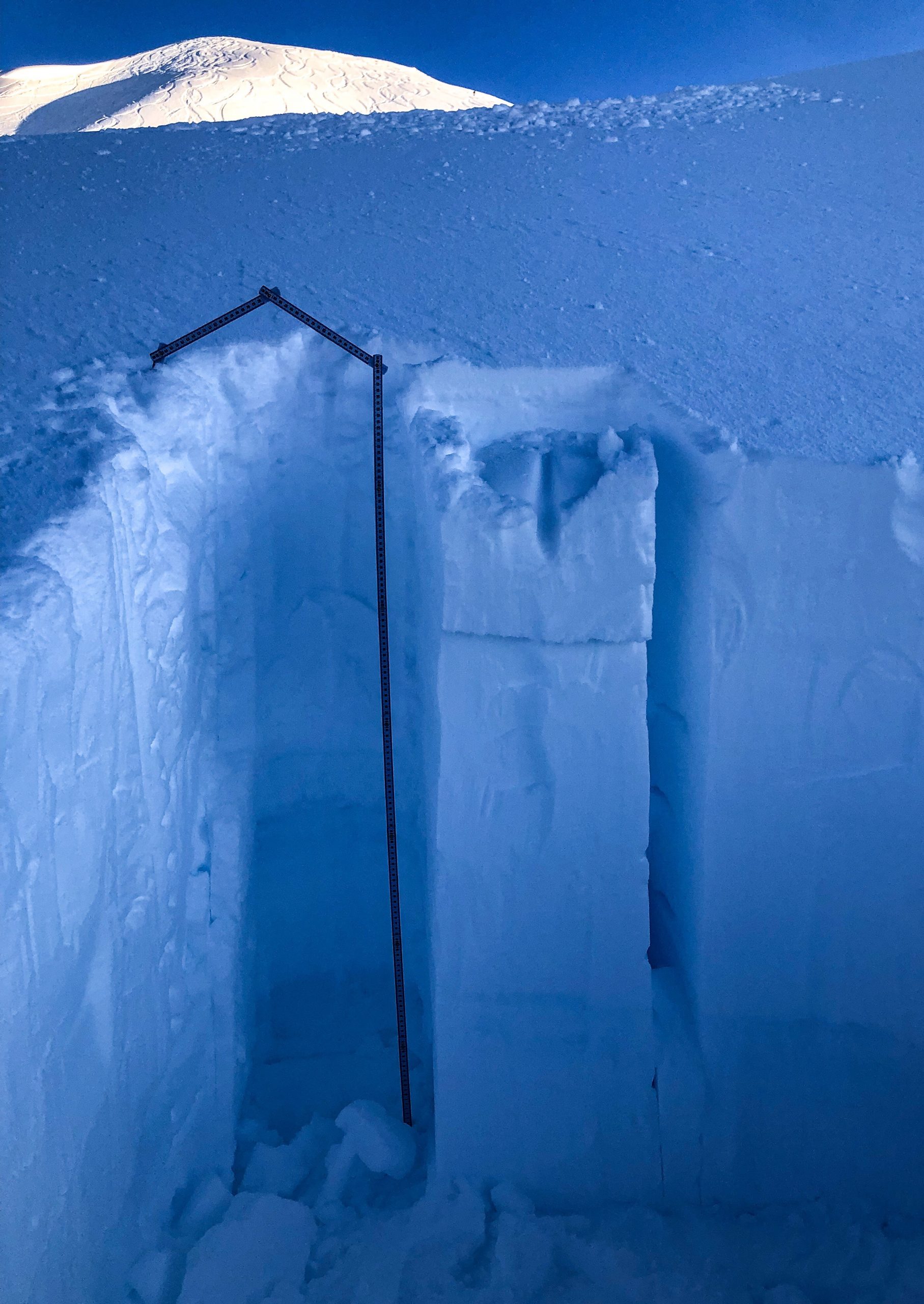
Observer Eric Roberts found yesterday what we have been finding at elevations around 3,000′ and below- a stable snowpack. 

Additional Concern
  • Glide Avalanches
    Glide Avalanches
Glide Avalanches
Glide Avalanches are the release of the entire snow cover as a result of gliding over the ground. Glide avalanches can be composed of wet, moist, or almost entirely dry snow. They typically occur in very specific paths, where the slope is steep enough and the ground surface is relatively smooth. They are often proceeded by full depth cracks (glide cracks), though the time between the appearance of a crack and an avalanche can vary between seconds and months. Glide avalanches are unlikely to be triggered by a person, are nearly impossible to forecast, and thus pose a hazard that is extremely difficult to manage.
More info at Avalanche.org

Slowly opening glide cracks are become more common in popular areas at Turnagain Pass. Keep an eye out for these and avoid/limit any time spent underneath them. They are a completely unpredictable hazard and can release at anytime.

Glide cracks on north facing Corn Biscuit, pictured yesterday by observer Allen Dahl. 


Looking ahead to our next snowfall, a crop of surface hoar and near surface facets are forming on the surface of the snowpack.

Surface hoar forming from the past two days of cold and clear weather. Photo: Allen Dahl.

Weather
Sat, December 21st, 2019

Yesterday:  Clear skies were over the region with patchy valley fog in places. Ridgetop winds were light (5-10mph) and westerly. Temperatures have been in the low teens along ridgelines and in the single digits in valley bottoms and along Turnagain Pass.

Today:  Partly cloudy to possibly some gray skies are forecast as high clouds are moving through Southcentral. Ridgetop winds look to remain light and westerly today with a bump into the 15-20mph range this afternoon. Temperatures should remain near 10°F in valley bottoms and in the low teens along ridgetops.

Tomorrow:  One last clear(ish) day is on tap for Sunday before a series of cold winter storms heads in for the Christmas week! Ridgetop winds will shift around to an easterly direction tonight and will slowly increase on Sunday into the 15-20mph range by the late afternoon. Snow looks to begin falling Sunday evening. Temperatures will slowly rise with this system but will remain cold enough for snow to sea level. Stay tuned!

PRECIPITATION 24-hour data (6am – 6am)

Temp Avg (F) Snow (in) Water (in) Snow Depth (in)
Center Ridge (1880′) 10 0 0 28
Summit Lake (1400′) 7 0 0 7
Alyeska Mid (1700′) 12 0 0 16

RIDGETOP 24-hour data (6am – 6am)

Temp Avg (F) Wind Dir Wind Avg (mph) Wind Gust (mph)
Sunburst (3812′) 12 NW 6 17
Seattle Ridge (2400′) N/A* N/A* N/A* N/A*

*Seattle Ridge weather station is not reporting, we hope to have it back online this week.

Observations
Recent Observations for Turnagain Pass
Date Region Location
04/16/24 Turnagain Observation: Cornbiscuit
04/15/24 Turnagain Observation: Taylor Pass
04/15/24 Turnagain Observation: Seward Highway – Tern Lake to Portage
04/14/24 Turnagain Observation: Sunburst
04/14/24 Turnagain Observation: Turnagain Pass Snomo
04/13/24 Turnagain Observation: Spokane Creek
04/11/24 Turnagain Observation: Tincan
04/10/24 Turnagain Avalanche: Seattle Ridge
04/10/24 Turnagain Observation: Cornbiscuit South Face
04/10/24 Turnagain Avalanche: Tincan
Riding Areas

The riding areas page has moved. Please click here & update your bookmarks.


Subscribe to Turnagain Pass
Avalanche Forecast by Email

This is a general backcountry avalanche advisory issued for Turnagain Arm with Turnagain Pass as the core advisory area. This advisory does not apply to highways, railroads or operating ski areas.