Turnagain Pass
|
![]() ![]() |
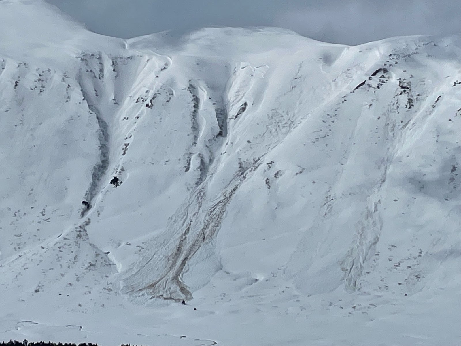
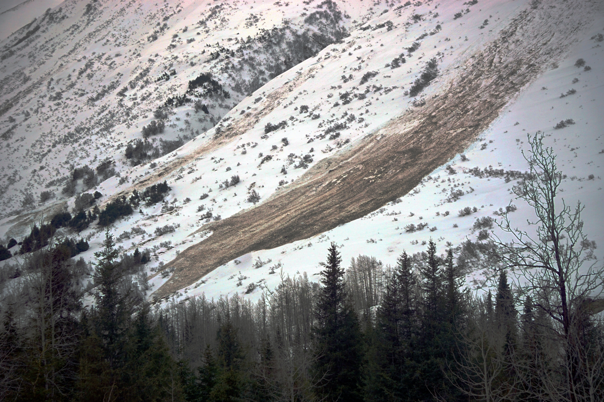
The avalanche danger is CONSIDERABLE above 1000′. Storm slabs and wind slabs 1-3+’ deep that formed during the storm over the past 2 days are the primary avalanche problems and are likely to be triggered by a person and possible for natural triggering. Cautious route finding and careful snowpack evaluation is recommended before entering avalanche terrain today. In addition, we could see more wet slab activity especially on south facing terrain in areas with a thinner snowpack that are getting added melt from the sun. Continued glide avalanche activity is also likely and we recommend avoiding spending time underneath glide cracks.
Below 1000′ the avalanche danger is MODERATE. Warm temperatures and rain at lower elevations during the storm have created an unconsolidated wet snowpack that could easily lead to wet loose avalanches in steeper terrain.
MONDAY AVALANCHE OUTLOOK: There will be no forecast issued tomorrow, Monday. The next forecast will be Tuesday, April 26th at 7am. Avalanche conditions are expected to remain dangerous for wet avalanches, especially in the afternoon on southerly slopes seeing direct sunshine. In the higher elevation shady terrain the danger is trending to MODERATE as storm slab and wind slab avalanches become more difficult to trigger.
![]() |
![]() |
![]() |
![]() |
![]() |
|
Travel Advice | Generally safe avalanche conditions. Watch for unstable snow on isolated terrain features. | Heightened avalanche conditions on specific terrain features. Evaluate snow and terrain carefully; identify features of concern. | Dangerous avalanche conditions. Careful snowpack evaluation, cautious route-finding, and conservative decision-making essential. | Very dangerous avalanche conditions. Travel in avalanche terrain not recommended. | Extraordinarily dangerous avalanche conditions. Avoid all avalanche terrain. |
Likelihood of Avalanches | Natural and human-triggered avalanches unlikely. | Natural avalanches unlikely; human-triggered avalanches possible. | Natural avalanches possible; human-triggered avalanches likely. | Natural avalanches likely; human-triggered avalanches very likely. | Natural and human-triggered avalanches certain. |
Avalanche Size and Distribution | Small avalanches in isolated areas or extreme terrain. | Small avalanches in specific areas; or large avalanches in isolated areas. | Small avalanches in many areas; or large avalanches in specific areas; or very large avalanches in isolated areas. | Large avalanches in many areas; or very large avalanches in specific areas. | Very large avalanches in many areas. |
Lots of new avalanches were observed yesterday that occurred sometime during the storm on Friday or Saturday. There is a mix of large wet slabs that released at lower elevations on more southerly aspects and storm slabs that included just the storm snow above the old melt freeze surface that were releasing naturally yesterday.
Wet slabs along Seattle Ridge: Several new avalanches along Seattle Ridge appeared to be wet slabs caused by melt water percolating through the snowpack, which is typical of the spring shed cycle. These can look similar to glide avalanches but in general the bed surface is not on the ground and they can have different character in terms of propagation across the slope compared to typical glide avalanches.
Large wet slab on Seattle Ridge near the motorized parking lot. Photo from Jason Koenigsberg 4.23.22
Another large wet slab on Seattle Ridge near Bertha Creek Campground with very dirty debris. 4.23.22
Debris from wet slab pictured above. 4.23.22
Storm slabs releasing at interface with the old melt freeze surface: Despite the low visibility for most of the day yesterday there were a handful of observations of storm slabs releasing in both Turnagain Pass and Portage area. These ranges from roughly 1-3+’ deep depending on wind loading and how much new snow the area received.
Large storm slab at the end of Center Ridge where it turns into Lyon Creek Drainage. Photo Jason Koenigsberg 4.23.22
Several natural storm slabs released on the north aspect of Pete’s South while we were touring on Pete’s N. Photo 4.23.22
Signal Word | Size (D scale) | Simple Descriptor |
Small | 1 | Unlikely to bury a person |
Large | 2 | Can bury a person |
Very Large | 3 | Can destroy a house |
Historic | 4 & 5 | Can destroy part or all of a village |
The spring storm over the past 3 days has forced us out of the easy going spring avalanche mindset and back into a mindset of active natural avalanches and dry snow avalanche problems at higher elevations. Today the storm has ended and we are expecting warm temperatures and broken cloud cover that could lead to more natural and human triggered avalanches at the interface of the new snow and old snow. Warming from the sun and relatively high air temperatures could be enough to cause the new snow to release naturally or be primed for human triggering, as we saw yesterday on Pete’s (see ob here). These spring storms are tricky to predict so we are taking a cautious approach to forecasting the potential for avalanche activity at the interface of the new snow and old snow surface.
The primary avalanche problems today are storm slabs and wind slabs that were created during the storm on Friday and Saturday, and do not seem to be bonding well to the old snow surface. The depth of these avalanches could range from 1-3+’ depending on wind loading and the amount of snowfall received in the area you are travelling. Coastal areas near Portage and Placer received 3+’ of new snow compared to 1-1.5′ for Turnagain Pass and Girdwood. These surface snow avalanches were occurring on all aspects above 1500′ yesterday. The high water content of the new snow means that even a relatively small storm slab or wind slab can be very heavy and have more force than you might expect.
To evaluate whether these avalanches are an issue today keep an eye out for red flags, especially any natural avalanche triggered by warming from the sun, and use test slopes to get a sense for how the new snow is bonding to the old melt freeze surface.
Signal Word | Size (D scale) | Simple Descriptor |
Small | 1 | Unlikely to bury a person |
Large | 2 | Can bury a person |
Very Large | 3 | Can destroy a house |
Historic | 4 & 5 | Can destroy part or all of a village |
In addition to the surface snow avalanche problems, we have also been seeing the beginnings of the spring shed cycle over the past week, with large wet slab avalanches occurring in the Crow Creek area (see obs here and here), Gulch creek (see ob here), and along Seattle Ridge (see ob here). The warm temperatures and rain at lower elevations during the storm have continued to contribute to the wet slab potential and the possible addition of partially sunny skies today will add more melt water to the snowpack. Yesterday the snowpack was saturated below 1500′ where rain had fallen during the storm and there was no crust on the surface.
Most if not all of the wet slab activity we have seen so far is on southern aspects that have an overall thinner snowpack structure. This trend will likely continue, with melt water reaching deeper weak layers in areas with thinner snowpacks that are receiving additional melt water from the sun. We recommend avoiding spending time underneath south facing slopes that are receiving active solar melting today and may not have refrozen over the past two days with the warm temperatures and rain during the storm. It is difficult to predict the exact timing and location of wet slab avalanches, but a lot of the necessary ingredients are available now so a cautious approach to travelling in areas that have similar characteristics to where we have already seen wet slabs is prudent.
Glide Avalanches: The cycle of glide avalanche releases that had started prior to this last storm is likely still active so we recommend avoiding spending time underneath any visible glide cracks. These can release randomly and are generally very large and destructive avalanches.
Wet Loose Avalanches: Lots of fresh wet loose avalanches were visible yesterday and they were easy to trigger on any steeper slopes. Be aware of the force that wet slab avalanches can contain, especially on long planar slopes where they can pick up a head of steam and entrain a lot of snow.
Yesterday: Light to moderate rain up to about 1700′ transitioning to snow above that. Snow totals for the storm range from 1′ to 1.5′ of wet snow over the past 3 days for Turnagain Pass and Girdwood. Coastal areas near Portage and Placer likely received significantly more precipitation over the past 3 days, with up to 3+’ of snowfall. Winds were moderate out of the east in the 5-20 mph range with gusts up to 40 mph.
Today: No significant additional precipitation is expected today, but snow or rain showers are possible especially in coastal areas. Winds should be calm to light in the 0-10 mph range. Broken cloud cover is expected throughout the day with some areas of valley fog this morning. Temperatures are forecast to reach up to the mid 30s F at upper elevations and mid 40s F at lower elevations.
Tomorrow: Tomorrow and the first half of this week are looking very similar to today. With patchy cloud cover, light winds, and warm temperatures.
PRECIPITATION 24-hour data (6am – 6am)
Temp Avg (F) | Snow (in) | Water (in) | Snow Depth (in) | |
---|---|---|---|---|
Center Ridge (1880′) | 37 | 0 | 0.4 | 107 |
Summit Lake (1400′) | 37 | 0 | 0.1 | 33 |
Alyeska Mid (1700′) | 36 | 0 | 0.3 | NA |
RIDGETOP 24-hour data (6am – 6am)
Temp Avg (F) | Wind Dir | Wind Avg (mph) | Wind Gust (mph) | |
---|---|---|---|---|
Sunburst (3812′) | 27 | ENE | 15 | 43 |
Seattle Ridge (2400′) | 31 | SE | 5 | 16 |
Date | Region | Location | Observer |
---|---|---|---|
10/27/24 | Turnagain | Observation: Tincan | Michael Kerst |
10/21/24 | Turnagain | Observation: Turnagain Pass Road Observation | Trevor Clayton |
10/19/24 | Turnagain | Observation: Tincan – Below Todds Run | Andy Moderow |
10/18/24 | Turnagain | Observation: Taylor Pass | Eli Neuffer |
10/15/24 | Turnagain | Observation: Tincan Common | John Sykes Forecaster |
10/14/24 | Turnagain | Avalanche: Tincan | CNFAC Staff |
05/13/24 | Turnagain | Observation: Eddie’s, Sunburst, Seattle, Cornbiscuit, Pete’s South | H Thamm |
05/13/24 | Turnagain | Observation: Turnagain Pass non-motorized side | Amy Holman |
05/12/24 | Turnagain | Observation: Warm up Bowl | Tony Naciuk |
05/07/24 | Turnagain | Observation: Turnagain Pass Wet Slabs | A S |
The riding areas page has moved. Please click here & update your bookmarks.
Subscribe to Turnagain Pass
Avalanche Forecast by Email