Turnagain Pass RSS

Archives
ARCHIVED - Forecasts expire after 24 hours.
Issued
Sun, April 18th, 2021 - 7:00AM
Expires
Mon, April 19th, 2021 - 7:00AM
Forecaster
Aleph Johnston-Bloom
Avalanche risk The Bottom Line

We have issued a SPECIAL AVALANCHE BULLETIN for the mountains surrounding Girdwood, Portage Valley, Turnagain Pass and the Kenai mountains to Seward. This bulletin is in effect until tonight. However, dangerous avalanche conditions are expected to continue into this week.

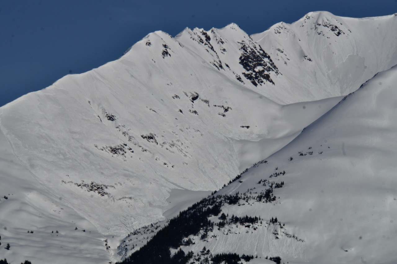
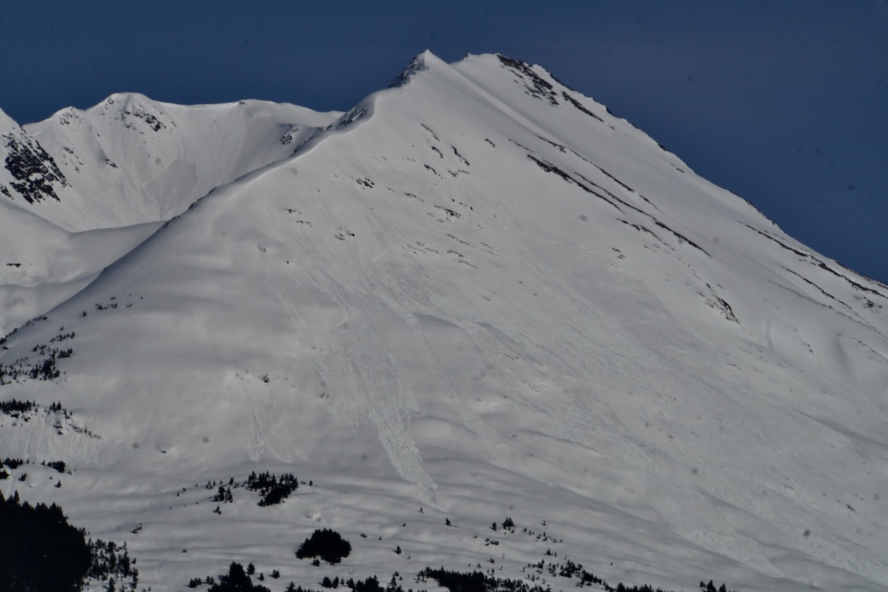
The avalanche danger is MODERATE this morning and expected to rise to HIGH again on east, south and west facing slopes today as intense sunshine and very warm temperatures melt surface crusts and destabilize the snowpack. Natural wet loose and wet slab avalanches will become likely during the heat of the day on slopes with direct sunshine. Human triggered slab avalanches are likely on sunny slopes (east, south and west aspects) with moist or wet surface snow. Northern aspects, shaded slopes, will have a MODERATE danger where triggering a slab avalanche 1-4′ deep, composed of last week’s storm snow, is still possible.

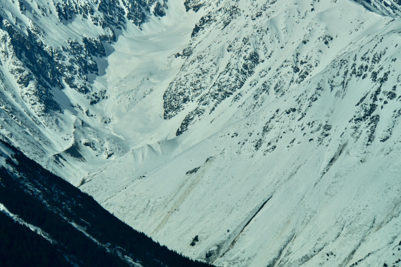
PORTAGE VALLEY, CROW PASS: There is potential for avalanche debris, from a slide occurring above, to run to low elevation terrain. Avoiding summer trails that run through avalanche runout zones, such as Byron Glacier and Crow Pass Trails, is recommended.

MONDAY AVALANCHE OUTLOOK: No avalanche forecast will be issued tomorrow. Similar avalanche conditions are expected on Monday, Apr 19th. Expect another day of warm temperatures, sunshine, and avalanches.

Special Announcements

CNFAIC End Of Season Operations:  Daily avalanche forecasts are ending today as our forecast season and funding winds down. We are switching to 4 forecasts/week (Tues, Thur, Sat, Sun). There is an avalanche ‘outlook’ posted for Monday and our next forecast will be issued Tuesday morning.

Hatcher Pass:  Be sure to check out HPAC’s Saturday morning forecast at hpavalanche.org. The road to Hatcher Pass remains closed at MP10. For updates see AK 511 and follow AKDOT&PF on social media.

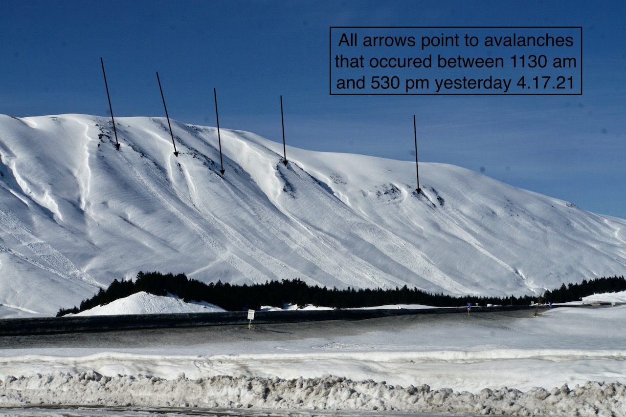
Chugach State Park:  Rapid warming of the snowpack and dangerous avalanche conditions are being seen region-wide. Yesterday avalanches were reported at the Mile High trail head in Eagle River and an avalanche hit the Arctic Valley Road. A report was sent in from Falls Creek on Friday where several natural avalanches were seen in motion.

Sun, April 18th, 2021
Alpine
Above 2,500'
4 - High
Avalanche risk
Treeline
1,000'-2,500'
4 - High
Avalanche risk
Below Treeline
Below 1,000'
4 - High
Avalanche risk
0 - No Rating
1 - Low
2 - Moderate
3 - Considerable
4 - High
5 - Extreme
Avalanche risk Avalanche risk Avalanche risk Avalanche risk Avalanche risk
Travel Advice Generally safe avalanche conditions. Watch for unstable snow on isolated terrain features. Heightened avalanche conditions on specific terrain features. Evaluate snow and terrain carefully; identify features of concern. Dangerous avalanche conditions. Careful snowpack evaluation, cautious route-finding, and conservative decision-making essential. Very dangerous avalanche conditions. Travel in avalanche terrain not recommended. Extraordinarily dangerous avalanche conditions. Avoid all avalanche terrain.
Likelihood of Avalanches Natural and human-triggered avalanches unlikely. Natural avalanches unlikely; human-triggered avalanches possible. Natural avalanches possible; human-triggered avalanches likely. Natural avalanches likely; human-triggered avalanches very likely. Natural and human-triggered avalanches certain.
Avalanche Size and Distribution Small avalanches in isolated areas or extreme terrain. Small avalanches in specific areas; or large avalanches in isolated areas. Small avalanches in many areas; or large avalanches in specific areas; or very large avalanches in isolated areas. Large avalanches in many areas; or very large avalanches in specific areas. Very large avalanches in many areas.
Recent Avalanches

Avalanches…. and more avalanches… and more avalanches…

There were numerous natural wet loose, wet slabs and even some glide avalanches observed yesterday region-wide. There were new avalanches observed on Penguin Ridge, Goat mountain, Seattle Ridge, Tincan, Lipps, Petes North and Petes South, Moose Mountain, Lonestar, Fresno, Summit Peak and the list goes on. These avalanches occurred on easterly, southerly and westerly aspects during the heat of the afternoon and evening hours.

Natural wet loose and wet slab avalanches on Petes North, 4.17.21. Photo: Andy Moderow

Natural wet loose and wet slab avalanches on Petes South, 4.17.21. Photo: Andy Moderow.

Natural slab avalanches Moose Mountain, 4.17.21. part of the path had slid prior to driving by at 12 pm and then more released around 3 pm yesterday, 4.17.21. Photo: Andy Moderow

Avalanche Problem 1
  • Spring Conditions
    Spring Conditions
  • Certain
    Very Likely
    Likely
    Possible
    Unlikely
    Likelihood
  • Historic (D4-5)
    Very Large (D3)
    Large (D2)
    Small (D1)
    Size
Spring Conditions
Warmth has a tricky effect on snow. On the one hand it speeds up the stabilization of the snowpack (reduces the chance of slab avalanches). But a SUDDEN rise of temperature increases the chance of slab avalanches considerably. When this warm period is followed by cooling down, then the chance of slab avalanches reduces. Even more so: the more often the temperature changes, the more stable the snowpack becomes when looking at slab avalanches. Once the temperature becomes too warm we have to deal with wet snow avalanches.

Likelihood of Avalanches
Terms such as "unlikely", "likely", and "certain" are used to define the scale, with the chance of triggering or observing avalanches increasing as we move up the scale. For our purposes, "Unlikely" means that few avalanches could be triggered in avalanche terrain and natural avalanches are not expected. "Certain" means that humans will be able to trigger avalanches on many slopes, and natural avalanches are expected.

Size of Avalanches
Avalanche size is defined by the largest potential avalanche, or expected range of sizes related to the problem in question. Assigned size is a qualitative estimate based on the destructive classification system and requires specialists to estimate the harm avalanches may cause to hypothetical objects located in the avalanche track (AAA 2016, CAA 2014). Under this schema, "Small" avalanches are not large enough to bury humans and are relatively harmless unless they carry people over cliffs or through trees or rocks. Moving up the scale, avalanches become "Large" enough to bury, injure, or kill people. "Very Large" avalanches may bury or destroy vehicles or houses, and "Historic" avalanches are massive events capable of altering the landscape.

Signal Word Size (D scale) Simple Descriptor
Small 1 Unlikely to bury a person
Large 2 Can bury a person
Very Large 3 Can destroy a house
Historic 4 & 5 Can destroy part or all of a village
More info at Avalanche.org

After finally shaking off the cold grip of winter the mountains are saying ‘It’s getting hot in here, so shed off all your snow‘! The amount of avalanche activity in the past couple days is notable and today we expect the avalanche cycle to continue. Temperatures stayed warm overnight (40°F at 4200’ on Penguin ridge) and skies were partly cloudy so any freeze from radiant cooling will not likely be as pronounced as Friday night’s. Any crusts that formed will likely soften more rapidly. The only wild card in this is the wind. There have been easterly winds 15-30 mph gusting into the 40s. This could help things stay a bit cooler in the alpine…???

With our springtime avalanche problem icon we are trying to illustrate the increase in danger from morning to afternoon. With the clouds last night the danger might rise more quickly if there is not much of a surface crust today. As Wendy wrote yesterday, regardless of elevation, any slope in direct sunshine that has not avalanched, will be likely to do so today; especially steep rocky terrain.  This is the time of year to pay attention to aspect and which slopes get direct sunshine first. Remember this begins with east aspects, then south, then west as the sun makes its way across the sky.  Human triggered avalanches are very likely. Avoid being on, or under, steep terrain baking in the sun. Be aware of your exit routes.  If you ski or snowmachine on a northerly aspect make sure you don’t have to cross under southerly hazard as you head back to the car. Any surface crusts could deteriorate quickly, if you find yourself in soft mushy snow on a steep slope, it’s time to head for colder snow or a parking lot beverage.

Wet snow avalanches today may be either wet loose or wet slab, or a combination. They may begin to gouge down into lower layers as water makes its way deeper in the pack today. They may start small and if they are in steep sustained terrain, they could entrain enough volume and momentum to run to valley bottoms. Even a small wet sluff can be dangerous, as wet or moist snow is more difficult to escape from than dry snow and can pile up quickly in a terrain trap. There could also be some natural slab avalanches induced by the warming, or triggered by a wet loose avalanche that still mostly dry snow and blend the lines between a storm slab and wet slab. Again, we really can’t say it enough, this transition from cold snowpack to warm snowpack is tricky. There were slab avalanches triggered on the backside of Seattle Ridge on Friday that were comprised of cold snow heating up.

Glide avalanches: We have seen a few of these release over the past few days including Goat shoulder, Skookum and in Summit Lake. This are expected to continue to release with the warm conditions. Watch for and limit any exposure under glide cracks.

Wet loose avalanches that occurred yesterday, 4.17.21. There are a few slab avalanches that occurred during the storm on 4.14 as well.

Glide avalanches that occurred yesterday, 4.17.21 intermixed with wet avalanche activity on Goat shoulder.


Avalanche Problem 2
  • Storm Slabs
    Storm Slabs
  • Certain
    Very Likely
    Likely
    Possible
    Unlikely
    Likelihood
  • Historic (D4-5)
    Very Large (D3)
    Large (D2)
    Small (D1)
    Size
Storm Slabs
Storm Slab avalanches are the release of a cohesive layer (a slab) of new snow that breaks within new snow or on the old snow surface. Storm-slabs typically last between a few hours and few days (following snowfall). Storm-slabs that form over a persistent weak layer (surface hoar, depth hoar, or near-surface facets) may be termed Persistent Slabs or may develop into Persistent Slabs.

Likelihood of Avalanches
Terms such as "unlikely", "likely", and "certain" are used to define the scale, with the chance of triggering or observing avalanches increasing as we move up the scale. For our purposes, "Unlikely" means that few avalanches could be triggered in avalanche terrain and natural avalanches are not expected. "Certain" means that humans will be able to trigger avalanches on many slopes, and natural avalanches are expected.

Size of Avalanches
Avalanche size is defined by the largest potential avalanche, or expected range of sizes related to the problem in question. Assigned size is a qualitative estimate based on the destructive classification system and requires specialists to estimate the harm avalanches may cause to hypothetical objects located in the avalanche track (AAA 2016, CAA 2014). Under this schema, "Small" avalanches are not large enough to bury humans and are relatively harmless unless they carry people over cliffs or through trees or rocks. Moving up the scale, avalanches become "Large" enough to bury, injure, or kill people. "Very Large" avalanches may bury or destroy vehicles or houses, and "Historic" avalanches are massive events capable of altering the landscape.

Signal Word Size (D scale) Simple Descriptor
Small 1 Unlikely to bury a person
Large 2 Can bury a person
Very Large 3 Can destroy a house
Historic 4 & 5 Can destroy part or all of a village
More info at Avalanche.org

The snow from this past week is that is sitting on shaded aspects, that are not seeing much direct sunshine and surface melting, could still be an issue. This storm snow is a dense slab anywhere from 3-4′ deep in the mountains around Girdwood, and ~2′ deep at Turnagain Pass. The warm ambient air temperatures can do two things, one help the slab bond to the snow below or it can make the slab even more cohesive and increase the likelihood of triggering an avalanche. This transition time as a cold snowpack warms can be hard to predict, as the snowpack doesn’t quite fit into a winter or spring pattern. You might find a northerly slope where this slab is reactive today. It’s important to pay attention to signs of instability and think about slope consequences if you were to trigger an avalanche.

Persistent slabs: There are still older weak layers of facets and surface hoar in the snowpack under the recent snow. These layers are more pronounced in areas such as Summit Lake with a shallower snowpack. As we move forward and watch what this spring transition does, we should keep in mind these layers exist and that avalanches could step down on northerly slopes as well as southerly.

Cornices:  These grew during last week’s storm and are becoming more tender with the springtime warming. Be sure and steer well away from them along ridge lines and limit exposure under them.

Weather
Sun, April 18th, 2021

Yesterday: Skies were mostly sunny with high overcast developing in the afternoon. Temperatures were in the 40°Fs and low 50°Fs and winds were calm. Overnight temperatures were in the mid 30°Fs to mid 40°Fs. Winds were light and easterly increasing in the early morning to 15-30 mph gusting into the 40s. Skies were partly cloudy overnight.

Today: Skies will be mostly sunny today with temperatures in the 40°Fs and 50°Fs. Winds will be easterly 15-30 mph with gusts into the 40s. Overnight skies will be mostly clear and temperatures will be in the mid 30°Fs to mid 40°Fs. Winds will be easterly 5-15 mph with gusts into the 20s.

Tomorrow: Skies will be mostly sunny with highs in the 40°Fs and 50°Fs and light winds. Clouds increase overnight with a chance of rain showers and temperatures in the 40°Fs. After some clouds on Tuesday we shift back to clear and sunny for the remainder of the week.

PRECIPITATION 24-hour data (6am – 6am)

Temp Avg (F) Snow (in) Water (in) Snow Depth (in)
Center Ridge (1880′) 44 0 0 108
Summit Lake (1400′) 41 0 0 42
Alyeska Mid (1700′) 43 0 0 122

RIDGETOP 24-hour data (6am – 6am)

Temp Avg (F) Wind Dir Wind Avg (mph) Wind Gust (mph)
Sunburst (3812′) 41 NE 9 47
Seattle Ridge (2400′) 49 SE 4 21
Observations
Recent Observations for Turnagain Pass
Date Region Location
04/16/24 Turnagain Observation: Cornbiscuit
04/15/24 Turnagain Observation: Taylor Pass
04/15/24 Turnagain Observation: Seward Highway – Tern Lake to Portage
04/14/24 Turnagain Observation: Sunburst
04/14/24 Turnagain Observation: Turnagain Pass Snomo
04/13/24 Turnagain Observation: Spokane Creek
04/11/24 Turnagain Observation: Tincan
04/10/24 Turnagain Avalanche: Seattle Ridge
04/10/24 Turnagain Observation: Cornbiscuit South Face
04/10/24 Turnagain Avalanche: Tincan
Riding Areas

The riding areas page has moved. Please click here & update your bookmarks.


Subscribe to Turnagain Pass
Avalanche Forecast by Email

This is a general backcountry avalanche advisory issued for Turnagain Arm with Turnagain Pass as the core advisory area. This advisory does not apply to highways, railroads or operating ski areas.