Turnagain Pass RSS

Archives
ARCHIVED - Forecasts expire after 24 hours.
Issued
Tue, April 19th, 2022 - 7:00AM
Expires
Wed, April 20th, 2022 - 7:00AM
Forecaster
Wendy Wagner
Avalanche risk The Bottom Line

A LOW avalanche danger remains over the region. Although it will be unlikely a person will trigger an avalanche, there are still concerns to be aware of. Cornices are very large and can be triggered by people along ridgelines. If the sun heats up the solar aspects enough this afternoon/evening, wet loose avalanches may be triggered. Glide cracks are releasing into avalanches, avoid time under cracks and avoid areas where glide avalanches are occurring regularly such as under Seattle Ridge.

WEDNESDAY AVALANCHE OUTLOOK:  There will be no forecast issued tomorrow, Wednesday. The next forecast will be on Thursday, April 21st at 7am. Avalanche conditions will be similar to today and the danger will remain generally LOW. Watch for late afternoon surface heating on sun-baked slopes. Wet loose avalanches could be seen or triggered during the afternoon/evening.

Special Announcements
  • NEW Sunburst Webcam! If you have not seen the images yet, they are on the sunburst weather station page – at the bottom. Thank you to all the members and donators that made this possible through the Friend of the Chugach Avalanche Center!
  • End of Season Operations:  Forecasts will be issued on Tuesday, Thursday, Saturday and Sunday through the end of April. If a dramatic change in avalanche conditions occurs on an off day, we will provide a forecast. The final forecast will be on Saturday, April 30th.
Tue, April 19th, 2022
Alpine
Above 2,500'
1 - Low
Avalanche risk
Treeline
1,000'-2,500'
1 - Low
Avalanche risk
Below Treeline
Below 1,000'
1 - Low
Avalanche risk
0 - No Rating
1 - Low
2 - Moderate
3 - Considerable
4 - High
5 - Extreme
Avalanche risk Avalanche risk Avalanche risk Avalanche risk Avalanche risk
Travel Advice Generally safe avalanche conditions. Watch for unstable snow on isolated terrain features. Heightened avalanche conditions on specific terrain features. Evaluate snow and terrain carefully; identify features of concern. Dangerous avalanche conditions. Careful snowpack evaluation, cautious route-finding, and conservative decision-making essential. Very dangerous avalanche conditions. Travel in avalanche terrain not recommended. Extraordinarily dangerous avalanche conditions. Avoid all avalanche terrain.
Likelihood of Avalanches Natural and human-triggered avalanches unlikely. Natural avalanches unlikely; human-triggered avalanches possible. Natural avalanches possible; human-triggered avalanches likely. Natural avalanches likely; human-triggered avalanches very likely. Natural and human-triggered avalanches certain.
Avalanche Size and Distribution Small avalanches in isolated areas or extreme terrain. Small avalanches in specific areas; or large avalanches in isolated areas. Small avalanches in many areas; or large avalanches in specific areas; or very large avalanches in isolated areas. Large avalanches in many areas; or very large avalanches in specific areas. Very large avalanches in many areas.
Avalanche Problem 1
  • Normal Caution
    Normal Caution
  • Certain
    Very Likely
    Likely
    Possible
    Unlikely
    Likelihood
  • Historic (D4-5)
    Very Large (D3)
    Large (D2)
    Small (D1)
    Size
Normal Caution
Normal Caution means triggering an avalanche is unlikely but not impossible.

Likelihood of Avalanches
Terms such as "unlikely", "likely", and "certain" are used to define the scale, with the chance of triggering or observing avalanches increasing as we move up the scale. For our purposes, "Unlikely" means that few avalanches could be triggered in avalanche terrain and natural avalanches are not expected. "Certain" means that humans will be able to trigger avalanches on many slopes, and natural avalanches are expected.

Size of Avalanches
Avalanche size is defined by the largest potential avalanche, or expected range of sizes related to the problem in question. Assigned size is a qualitative estimate based on the destructive classification system and requires specialists to estimate the harm avalanches may cause to hypothetical objects located in the avalanche track (AAA 2016, CAA 2014). Under this schema, "Small" avalanches are not large enough to bury humans and are relatively harmless unless they carry people over cliffs or through trees or rocks. Moving up the scale, avalanches become "Large" enough to bury, injure, or kill people. "Very Large" avalanches may bury or destroy vehicles or houses, and "Historic" avalanches are massive events capable of altering the landscape.

Signal Word Size (D scale) Simple Descriptor
Small 1 Unlikely to bury a person
Large 2 Can bury a person
Very Large 3 Can destroy a house
Historic 4 & 5 Can destroy part or all of a village
More info at Avalanche.org

The high-pressure over Southcentral Alaska will continue for at least another couple days. With mostly clear skies and light winds, our main concerns for backcountry travel will relate to ‘Normal Caution’ issues. This includes wet loose avalanches late in the day, cornice falls, small slabs, and glide avalanches.

Wet loose avalanches:  The springtime freeze-thaw cycle will continue like clockwork the next couple days. The snow surface is able to re-freeze overnight, due to clear skies, then heat up considerably during the day. The middle of the day (solar noon) is around 2pm right now. The hottest part of the day is a couple hours after that, between 3-5pm. Paying close attention to how sloppy and wet the snow surface gets late in the day is key. Once our boots punch though wet snow to the boot-tops it is time to head to a cooler aspect. Wet loose avalanches can start small and grow quite large on steep sustained slopes.

Cornices:  Although we have not heard of a cornice fall in the past several days, we have to assume they are getting weaker and closer to failure each spring day. It is worth it to us, and anyone under us, to give these monsters a very wide berth. They can be very dangerous and life threatening.

If you are headed to the upper elevation dry and shaded aspects, remember there was some wind last Friday. Shallow lingering wind slabs could still be littered about. Always keep an eye out for hollow feeling snow, cracking in the snow around you, and any signs of wind loading. In addition, keeping strict on safe travel protocol is a good habit during ‘green light’ conditions as well as red light. The main things are exposing only one person at a time, having escape routes planned, and watching your partners closely.


Extremely large cornices overhang the Byron Glacier Valley. If one of these is to fall, it will run over the famous ‘ice caves’ that are essentially formed by avalanche debris that does not completely melt during the summer. It is prudent to avoid this area until the snow has already avalanched. Photo taken Sunday, 4.17.22. 

Avalanche Problem 2
  • Glide Avalanches
    Glide Avalanches
  • Historic (D4-5)
    Very Large (D3)
    Large (D2)
    Small (D1)
    Size
Glide Avalanches
Glide Avalanches are the release of the entire snow cover as a result of gliding over the ground. Glide avalanches can be composed of wet, moist, or almost entirely dry snow. They typically occur in very specific paths, where the slope is steep enough and the ground surface is relatively smooth. They are often proceeded by full depth cracks (glide cracks), though the time between the appearance of a crack and an avalanche can vary between seconds and months. Glide avalanches are unlikely to be triggered by a person, are nearly impossible to forecast, and thus pose a hazard that is extremely difficult to manage.

Size of Avalanches
Avalanche size is defined by the largest potential avalanche, or expected range of sizes related to the problem in question. Assigned size is a qualitative estimate based on the destructive classification system and requires specialists to estimate the harm avalanches may cause to hypothetical objects located in the avalanche track (AAA 2016, CAA 2014). Under this schema, "Small" avalanches are not large enough to bury humans and are relatively harmless unless they carry people over cliffs or through trees or rocks. Moving up the scale, avalanches become "Large" enough to bury, injure, or kill people. "Very Large" avalanches may bury or destroy vehicles or houses, and "Historic" avalanches are massive events capable of altering the landscape.

Signal Word Size (D scale) Simple Descriptor
Small 1 Unlikely to bury a person
Large 2 Can bury a person
Very Large 3 Can destroy a house
Historic 4 & 5 Can destroy part or all of a village
More info at Avalanche.org

Glide avalanches are occurring daily from Girdwood to Seward. They are easy to see because they leave a dark stain on the track of the avalanche and have some dirt entrained in the debris. They are often, but not always, preceded by a crack. The crack is usually dark and easy to see, giving us clues that a glide avalanche could happen at some point. They are not triggered by people, rather occur unpredictably. All in all, staying out from under glide cracks and avoiding areas other glides have occurred is a good bet. Avoiding the bottom of Seattle Ridge is a great example as many glide avalanches are occurring on the road side (photo below).

Glide avalanche that pulled out a ‘slab’ of snow on the way down. This is on the road side of Seattle Ridge and occurred Sunday. Photo by Andy Moderow, 4.17.22.


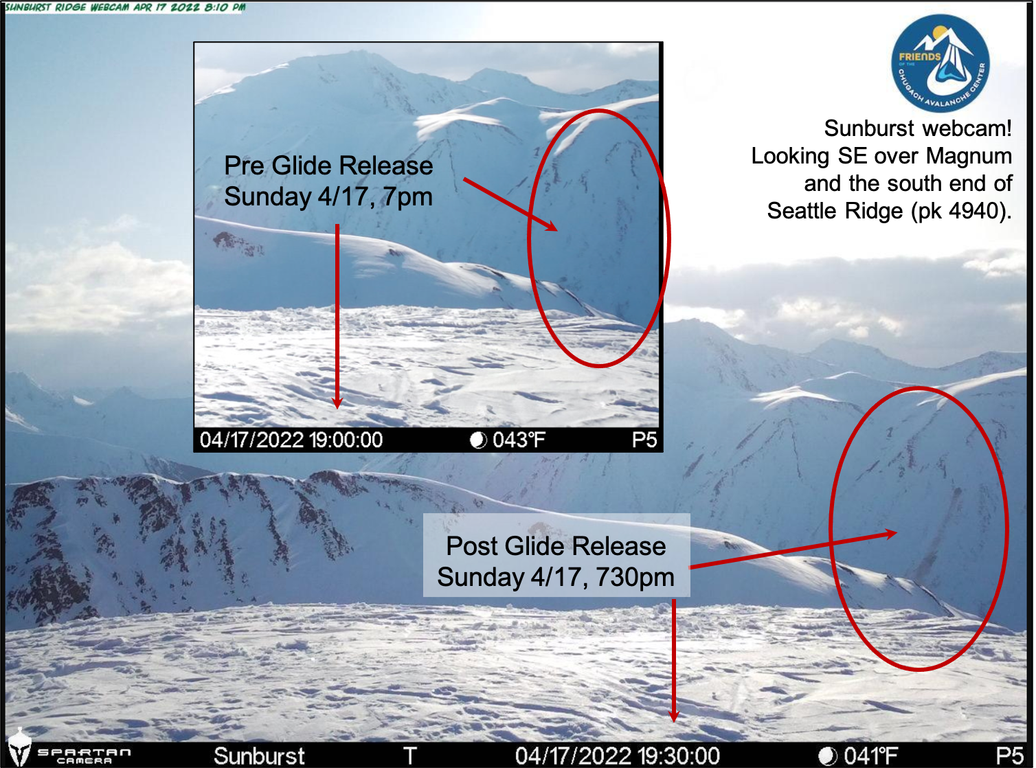
Glide release seen on the new Sunburst webcam.


Forecaster John Sykes and Intern Allen Dahl installed the camera provided by the Friends group last week. Thanks everyone – awesome seeing the sunrise on Peak 4940!

Weather
Tue, April 19th, 2022

Yesterday:  Sunny skies with light and variable winds were over the region. Temperatures climbed to 40F in the parking lots and into the upper 20’sF along ridgelines.

Today:  Continued clear skies with light southeast winds are forecast today. Temperatures have dipped into the 15-25F range overnight in valley bottoms and should climb into the 40’sF through the day. Ridgetops may also climb into the low 30’sF.

Tomorrow:  A few clouds may pass by tomorrow, but Wednesday should be a mostly sunny day with light southeast winds. Temperatures should again drop overnight to near 20F and climbing during the day to the 30 and 40’sF. A large scale pattern shift is taking shape for Thursday night into Saturday. Stay tuned – we may get a decent shot of snow during the day Friday.

PRECIPITATION 24-hour data (6am – 6am)

Temp Avg (F) Snow (in) Water (in) Snow Depth (in)
Center Ridge (1880′) 33 0 0 105
Summit Lake (1400′) 30 0 0 36
Alyeska Mid (1700′) 34 0 0 N/A

RIDGETOP 24-hour data (6am – 6am)

Temp Avg (F) Wind Dir Wind Avg (mph) Wind Gust (mph)
Sunburst (3812′) 24 variable 5 12
Seattle Ridge (2400′) 28 variable 3 7
Observations
Recent Observations for Turnagain Pass
Date Region Location
04/16/24 Turnagain Observation: Cornbiscuit
04/15/24 Turnagain Observation: Taylor Pass
04/15/24 Turnagain Observation: Seward Highway – Tern Lake to Portage
04/14/24 Turnagain Observation: Sunburst
04/14/24 Turnagain Observation: Turnagain Pass Snomo
04/13/24 Turnagain Observation: Spokane Creek
04/11/24 Turnagain Observation: Tincan
04/10/24 Turnagain Avalanche: Seattle Ridge
04/10/24 Turnagain Observation: Cornbiscuit South Face
04/10/24 Turnagain Avalanche: Tincan
Riding Areas

The riding areas page has moved. Please click here & update your bookmarks.


Subscribe to Turnagain Pass
Avalanche Forecast by Email

This is a general backcountry avalanche advisory issued for Turnagain Arm with Turnagain Pass as the core advisory area. This advisory does not apply to highways, railroads or operating ski areas.