Turnagain Pass RSS

Archives
ARCHIVED - Forecasts expire after 24 hours.
Issued
Sun, April 17th, 2022 - 7:00AM
Expires
Mon, April 18th, 2022 - 7:00AM
Forecaster
Andrew Schauer
Avalanche risk The Bottom Line

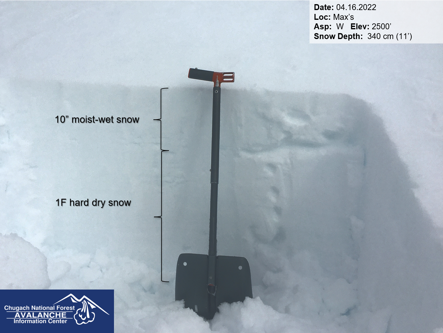
The avalanche danger is LOW, but that does not mean avalanches are impossible today. There is still a very small chance of finding isolated and stubborn wind slabs in upper elevations, and loose wet avalanches will become increasingly likely as the snow surface heats up later in the day. If you plan on accessing steep terrain today, keep an eye out for pockets of unstable snow, and use safe travel practices to minimize the consequences of triggering an unlikely avalanche.

MONDAY AVALANCHE OUTLOOK: There will be no avalanche forecast tomorrow. The next advisory will be posted Tuesday, April 19. Clouds are expected to break up later today through tonight, with mostly sunny skies tomorrow. Avalanche conditions should be similar to today, with surface warming leading to increasing likelihood of wet snow avalanches in the afternoon.

Special Announcements
  • AK DOT&PF:  On Monday, April 18th, the Hatcher Pass Road will be closed at MP 11, just past Skeetawk, for clearing the remaining avalanche debris. Mitigation evaluation first, then clearing can begin. Expect about a week for crews to finish and open the road to about MP 17.5 (Mine parking lot).
  • End of Season Operations:  This will be our last day of 7 day/wk forecasts. Beginning Monday, April 18, we will only be issuing forecasts on Tuesday, Thursday, Saturday and Sunday. The final forecast will be on Saturday April 30th.
Sun, April 17th, 2022
Alpine
Above 2,500'
1 - Low
Avalanche risk
Treeline
1,000'-2,500'
1 - Low
Avalanche risk
Below Treeline
Below 1,000'
1 - Low
Avalanche risk
0 - No Rating
1 - Low
2 - Moderate
3 - Considerable
4 - High
5 - Extreme
Avalanche risk Avalanche risk Avalanche risk Avalanche risk Avalanche risk
Travel Advice Generally safe avalanche conditions. Watch for unstable snow on isolated terrain features. Heightened avalanche conditions on specific terrain features. Evaluate snow and terrain carefully; identify features of concern. Dangerous avalanche conditions. Careful snowpack evaluation, cautious route-finding, and conservative decision-making essential. Very dangerous avalanche conditions. Travel in avalanche terrain not recommended. Extraordinarily dangerous avalanche conditions. Avoid all avalanche terrain.
Likelihood of Avalanches Natural and human-triggered avalanches unlikely. Natural avalanches unlikely; human-triggered avalanches possible. Natural avalanches possible; human-triggered avalanches likely. Natural avalanches likely; human-triggered avalanches very likely. Natural and human-triggered avalanches certain.
Avalanche Size and Distribution Small avalanches in isolated areas or extreme terrain. Small avalanches in specific areas; or large avalanches in isolated areas. Small avalanches in many areas; or large avalanches in specific areas; or very large avalanches in isolated areas. Large avalanches in many areas; or very large avalanches in specific areas. Very large avalanches in many areas.
Avalanche Problem 1
  • Normal Caution
    Normal Caution
  • Certain
    Very Likely
    Likely
    Possible
    Unlikely
    Likelihood
  • Historic (D4-5)
    Very Large (D3)
    Large (D2)
    Small (D1)
    Size
Normal Caution
Normal Caution means triggering an avalanche is unlikely but not impossible.

Likelihood of Avalanches
Terms such as "unlikely", "likely", and "certain" are used to define the scale, with the chance of triggering or observing avalanches increasing as we move up the scale. For our purposes, "Unlikely" means that few avalanches could be triggered in avalanche terrain and natural avalanches are not expected. "Certain" means that humans will be able to trigger avalanches on many slopes, and natural avalanches are expected.

Size of Avalanches
Avalanche size is defined by the largest potential avalanche, or expected range of sizes related to the problem in question. Assigned size is a qualitative estimate based on the destructive classification system and requires specialists to estimate the harm avalanches may cause to hypothetical objects located in the avalanche track (AAA 2016, CAA 2014). Under this schema, "Small" avalanches are not large enough to bury humans and are relatively harmless unless they carry people over cliffs or through trees or rocks. Moving up the scale, avalanches become "Large" enough to bury, injure, or kill people. "Very Large" avalanches may bury or destroy vehicles or houses, and "Historic" avalanches are massive events capable of altering the landscape.

Signal Word Size (D scale) Simple Descriptor
Small 1 Unlikely to bury a person
Large 2 Can bury a person
Very Large 3 Can destroy a house
Historic 4 & 5 Can destroy part or all of a village
More info at Avalanche.org

With a quiet day of weather on tap and no concerning persistent weak layers in the upper snowpack, it is unlikely a person will trigger an avalanche today. Although that probability is low, it never goes to zero. Be on the lookout for isolated pockets of unstable snow, especially in the upper elevations where there may be some lingering wind slabs. You may identify these by seeing changes in the texture on the snow surface, or feeling a hollow or punchy snow over softer snow. If you notice any of these signs, or any ‘red flags’ indicating unstable snow (shooting cracks, collapsing, fresh avalanches), adjust your travel plans to stay out of harm’s way.

If you are planning on getting into steeper terrain today, be sure to keep up safe travel protocols in case you find one of these unlikely pockets. This means only exposing one person at a time to steep terrain, and watching your partners from safe spots out of the way of avalanche paths. It also means having an exit plan in mind should the slope release.

Loose Wet Avalanches: Clouds are expected to break up later in the day. If enough sun is able to poke through and heat the snow surface, loose wet avalanches may be possible this afternoon. If you start to notice the snow surface becoming wet and unsupportable, it is time to move to shaded aspects.

Cornices: We have seen multiple large cornice failures recently (See this observation from Eddie’s for the latest action). These will remain tender today as temperatures warm. As always, keep plenty of space from the edge as you travel along ridgelines, and limit time spent traveling under cornices.

The melt-freeze cycles that we have seen this season are still only effecting the top 10-12″ snow at mid and upper elevations. We may see wet loose avalanches later today if enough sun pokes through to melt this upper snowpack. 04.16.2022

Avalanche Problem 2
  • Glide Avalanches
    Glide Avalanches
  • Historic (D4-5)
    Very Large (D3)
    Large (D2)
    Small (D1)
    Size
Glide Avalanches
Glide Avalanches are the release of the entire snow cover as a result of gliding over the ground. Glide avalanches can be composed of wet, moist, or almost entirely dry snow. They typically occur in very specific paths, where the slope is steep enough and the ground surface is relatively smooth. They are often proceeded by full depth cracks (glide cracks), though the time between the appearance of a crack and an avalanche can vary between seconds and months. Glide avalanches are unlikely to be triggered by a person, are nearly impossible to forecast, and thus pose a hazard that is extremely difficult to manage.

Size of Avalanches
Avalanche size is defined by the largest potential avalanche, or expected range of sizes related to the problem in question. Assigned size is a qualitative estimate based on the destructive classification system and requires specialists to estimate the harm avalanches may cause to hypothetical objects located in the avalanche track (AAA 2016, CAA 2014). Under this schema, "Small" avalanches are not large enough to bury humans and are relatively harmless unless they carry people over cliffs or through trees or rocks. Moving up the scale, avalanches become "Large" enough to bury, injure, or kill people. "Very Large" avalanches may bury or destroy vehicles or houses, and "Historic" avalanches are massive events capable of altering the landscape.

Signal Word Size (D scale) Simple Descriptor
Small 1 Unlikely to bury a person
Large 2 Can bury a person
Very Large 3 Can destroy a house
Historic 4 & 5 Can destroy part or all of a village
More info at Avalanche.org

Glide avalanches remain a concern today. These are unpredictable, but will become increasingly likely if the snow is able to heat up today. We have seen multiple releases over the past week, and some of them have been very large. This kind of avalanche is nothing to mess with, so be sure to limit the time you spend traveling under glide cracks.

Large glide crack in the foreground, with debris from multiple glide avalanches in the background looking up the drainage between Eddie’s and Tincan. Photo: Andy Moderow. 04.16.2022

Weather
Sun, April 17th, 2022

Yesterday: High temperatures were in the upper 20’s to low 40’s F under mostly cloudy skies. Winds were light and variable, predominantly out of the east in the morning and out of the west in the evening and overnight. No precipitation was recorded.

Today: Clouds are expected to start breaking up later in the day and overnight, with high temperatures in the upper 20’s to mid 30’s F and overnight lows in the mid 20’s F. Winds should be light at around 5 mph out of the west in the morning and east in the afternoon. There is a small chance of some isolated snow showers, but no major precipitation is expected.

Tomorrow: Clouds are expected to continue to break up overnight, with sunny skies tomorrow. Temperatures should be in the upper 20’s to upper 30’s F, with winds at 5 mph or less out of the east.

PRECIPITATION 24-hour data (6am – 6am)

Temp Avg (F) Snow (in) Water (in) Snow Depth (in)
Center Ridge (1880′) 34 0 0 107
Summit Lake (1400′) 33 0 0 37
Alyeska Mid (1700′) 33 0 0 106

RIDGETOP 24-hour data (6am – 6am)

Temp Avg (F) Wind Dir Wind Avg (mph) Wind Gust (mph)
Sunburst (3812′) 23 W 4 15
Seattle Ridge (2400′) 27 SE-NW 3 10
Observations
Recent Observations for Turnagain Pass
Date Region Location
04/16/24 Turnagain Observation: Cornbiscuit
04/15/24 Turnagain Observation: Taylor Pass
04/15/24 Turnagain Observation: Seward Highway – Tern Lake to Portage
04/14/24 Turnagain Observation: Sunburst
04/14/24 Turnagain Observation: Turnagain Pass Snomo
04/13/24 Turnagain Observation: Spokane Creek
04/11/24 Turnagain Observation: Tincan
04/10/24 Turnagain Avalanche: Seattle Ridge
04/10/24 Turnagain Observation: Cornbiscuit South Face
04/10/24 Turnagain Avalanche: Tincan
Riding Areas

The riding areas page has moved. Please click here & update your bookmarks.


Subscribe to Turnagain Pass
Avalanche Forecast by Email

This is a general backcountry avalanche advisory issued for Turnagain Arm with Turnagain Pass as the core advisory area. This advisory does not apply to highways, railroads or operating ski areas.