Turnagain Pass Avalanche Forecast RSS

Archives
ARCHIVED FORECAST - All forecasts expire after 24 hours from the posting date/time.
Issued
Wed, April 14th, 2021 - 7:00AM
Expires
Thu, April 15th, 2021 - 7:00AM
Forecaster
Aleph Johnston-Bloom
Avalanche Warning
Issued: April 14, 2021 6:00 am
Travel in avalanche terrain is not recommended. Avoid being on or beneath all steep slopes.
Avalanche risk The Bottom Line

We have issued a BACKCOUNTRY AVALANCHE WARNING through the National Weather Service for the Turnagain Pass area and surrounding mountains.

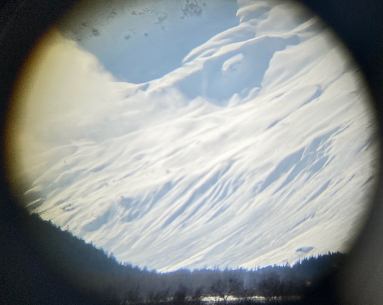
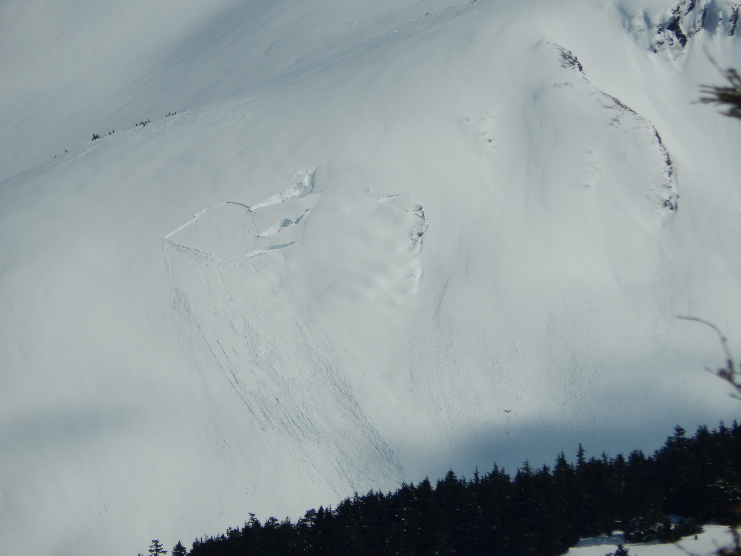
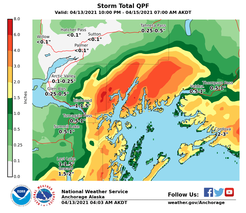
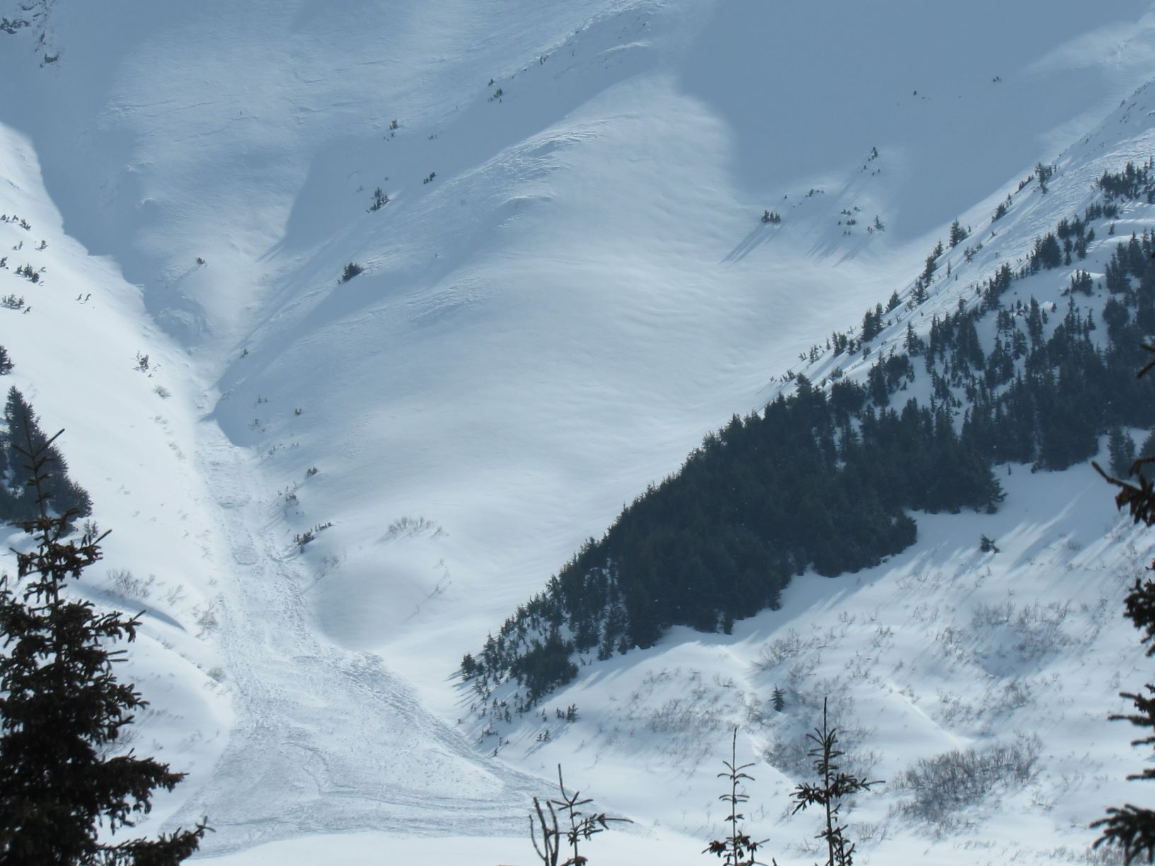
Heavy snowfall, rain, and strong winds have created a HIGH avalanche danger in the mountains surrounding Girdwood Valley, Turnagain Pass, Portage Valley, and areas on the Kenai including Summit Lake and the Seward zone. Dangerous avalanche conditions are expected on all slopes 30° and steeper. Avalanches are expected to release naturally, be easily triggered by people and send debris to valley floors. Travel in avalanche terrain is NOT recommended– including runout zones. Areas with steep slopes above should be avoided, such as the Byron Glacier Trail and other summer trails that pass under avalanche terrain.

*Roof Avalanches:  Warming temperatures and rain will cause roofs to continue to shed their snow. Pay special attention to children, pets and where you park your car.

Special Announcements

From Alaska Department of Transportation and Public Facilities:  There will be intermittent traffic delays for avalanche hazard reduction today, April 14, 2021 on the Seward Highway from mile post 45 to mile post 37. Summit Lake to the Wye.  Motorists should expect delays of 45 minutes from 11:00 am to 3:00 pm. Updates will be posted on the 511 system. http://511.alaska.gov/

CNFAIC End Of Season Operations:  Daily avalanche forecasts will continue through this weekend due to the weather forecast and elevated avalanche danger. We plan on switching to 4 days/week (Tues, Thur, Sat, Sun) beginning the Tuesday the 20th as our forecast season and funding winds down.

Thanks to our sponsors!
Wed, April 14th, 2021
Alpine
Above 2,500'
High (4)
Avalanche risk
Treeline
1,000'-2,500'
High (4)
Avalanche risk
Below Treeline
Below 1,000'
High (4)
Avalanche risk
Alpine
Above 2,500'
Avalanche risk
High (4)
Treeline
1,000'-2,500'
Avalanche risk
High (4)
Below Treeline
Below 1,000'
Avalanche risk
High (4)
Danger Scale:
No Rating (0)
Low (1)
Moderate (2)
Considerable (3)
High (4)
Extreme (5)
Recent Avalanches

Yesterday there were a number of avalanches observed that ran either during the Sunday/Monday storm or yesterday afternoon with the warming and sunshine. Avalanches were observed on Penguin Ridge above Girdwood, in Portage, Skookum, Turnagain Pass and Summit Lake, both slab avalanches and wet loose avalanches.

A large slab avalanche was observed on a NE aspect in Skookum Valley from the Seward Hwy, 4.13.21. Photo: Scott Hilliard. 

A slab avalanche that released next to the glide crack on the south side of Wolverine, 4.13.21. Photo: Paul Wunnike

Avalanche Problem 1
  • Wet Slab
    Wet Slab
  • Almost Certain
    Very Likely
    Likely
    Possible
    Unlikely
    Likelihood
  • Historic (D4-5)
    Very Large (D3)
    Large (D2)
    Small (D1)
    Size
Wet Slab
Wet Slab avalanches are the release of a cohesive layer of snow (a slab) that is generally moist or wet when the flow of liquid water weakens the bond between the slab and the surface below (snow or ground). They often occur during prolonged warming events and/or rain-on-snow events. Wet Slabs can be very unpredictable and destructive.

Likelihood of Avalanches
Terms such as "unlikely", "likely", and "certain" are used to define the scale, with the chance of triggering or observing avalanches increasing as we move up the scale. For our purposes, "Unlikely" means that few avalanches could be triggered in avalanche terrain and natural avalanches are not expected. "Certain" means that humans will be able to trigger avalanches on many slopes, and natural avalanches are expected.

Size of Avalanches
Avalanche size is defined by the largest potential avalanche, or expected range of sizes related to the problem in question. Assigned size is a qualitative estimate based on the destructive classification system and requires specialists to estimate the harm avalanches may cause to hypothetical objects located in the avalanche track (AAA 2016, CAA 2014). Under this schema, "Small" avalanches are not large enough to bury humans and are relatively harmless unless they carry people over cliffs or through trees or rocks. Moving up the scale, avalanches become "Large" enough to bury, injure, or kill people. "Very Large" avalanches may bury or destroy vehicles or houses, and "Historic" avalanches are massive events capable of altering the landscape.

Signal Word Size (D scale) Simple Descriptor
Small 1 Unlikely to bury a person
Large 2 Can bury a person
Very Large 3 Can destroy a house
Historic 4 & 5 Can destroy part or all of a village
More info at Avalanche.org

Travel in avalanche terrain is not recommended today. Human triggered avalanches are very likely. Large to very large avalanches are expected and could run into flat terrain below. Hopefully the weather forecast is enough to convince you that today is not the day to go to the mountains. Precipitation started around midnight last night and a total of 1-1.5″ of rain is forecast to fall up to 1600′ and possibly higher as temperatures continue rise. Above the rain/snow line this will fall as a foot or more of heavy snow. The winds are easterly 25-40 mph with gusts into the 60s. This comes after a day of warm temperatures, a night without a freeze below 2000′ and on the heels of the last storm that brought 1-2′ of snow to the forecast area. With the storm today our cold snowpack is getting its first real introduction to free water and some rapid loading, a recipe for avalanches. Natural wet loose avalanches and wet slab avalanches are likely today at elevations near and below where the rain/snow line ends up. In addition, storm slabs are expected at upper elevations, enhanced by wind loading and cornice falls are likely as well. Who knows glide avalanches might make an appearance too! There are buried crusts and we have been talking about buried weak layers for months now.  The loading today might tip the balance for avalanches stepping down to layers of buried surface hoar and/or facets (persistent weak layers) or a weak interface on a crust and result in an even larger avalanche. This is especially likely in Summit Lake south of Turnagain Pass, where there is an overall thinner snowpack with more advanced weak layers. The travel advice for the day is stay home and avoid roof avalanche hazard!

NWS graphic of the forecast amount of water (rain or moisture content in snow) for this storm.

Large recent avalanche on Johns Mountain in Summit Lake observed yesterday, 4.13.21. We expect large to very large avalanches today. Photo: Alex Mclain


Weather
Wed, April 14th, 2021

Yesterday: Skies were partly cloudy with scattered showers. High temperatures in the 40°Fs and winds were easterly 5-10 mph with gusts into the teens. Winds picked up in the evening and increased to 20-30 mph gusting into the 40s. Precipitation started around midnight with 0.3 SWE /1-5″ of snow falling.Today: Rain and snow that could be heavy at times, 0.8″ SWE and 8-15″ of snow. Rain/snow line is forecast to be around 1600′. High temperatures in the 40°Fs at sea level and high 20°Fs at 3000′. Winds are easterly 25-40 mph with gusts into the 60s. Overnight rain and snow continue  0.3 SWE/ 1-5″ snow, with lows in the high 30°Fs at sea level and 20°Fs in the alpine. Easterly winds remain strong initially and then decrease overnight.Tomorrow: Cloudy skies and rain and snow showers. High temperatures will be in the 20°Fs in the alpine and 30°Fs and 40°Fs in the mid and lower elevations. Winds will be easterly 5-15 mph with gusts into the 20s.PRECIPITATION 24-hour data (6am – 6am)

Temp Avg (F) Snow (in) Water (in) Snow Depth (in)
Center Ridge (1880′) 34 2 0.5 112
Summit Lake (1400′) 36 1 0.3 47
Alyeska Mid (1700′) 33 3 0.33 128

RIDGETOP 24-hour data (6am – 6am)

Temp Avg (F) Wind Dir Wind Avg (mph) Wind Gust (mph)
Sunburst (3812′) 23 NE 17 75
Seattle Ridge (2400′) 27 n/a* n/a* n/a*

*The Seattle Ridge wind sensor was rimed yesterday and is hopefully coming online this morning as strong winds set it free.

Observations
Recent Observations for Turnagain Pass
Date Region Location
05/22/23 Turnagain Avalanche: Tincan
05/12/23 Turnagain Avalanche: Tincan, Sunburst, Magnum, Cornbiscuit
05/07/23 Turnagain Observation: Tincan – Bear Tracks
05/05/23 Turnagain Observation: Seattle Ridge
05/02/23 Turnagain Observation: Cornbiscuit
05/02/23 Turnagain Observation: Seward Hwy Turnagain Pass
04/30/23 Turnagain Observation: Magnum
04/29/23 Turnagain Observation: Tincan
04/28/23 Turnagain Avalanche: Taylor Pass/Pastoral
04/28/23 Turnagain Avalanche: Tincan
Riding Areas
Updated Thu, June 01st, 2023

Status of riding areas across the Chugach NF is managed by the Glacier and Seward Ranger Districts, not avalanche center staff. Riding area information is posted as a public service to our users and updated based on snow depth and snow density to prevent resource damage at trailhead locations. Riding area questions contact: mailroom_r10_chugach@fs.fed.us

Area Status Weather & Riding Conditions
Glacier District
Johnson Pass
Closed
Closed May 15.
Placer River
Closed
Closed May 15.
Skookum Drainage
Closed
Will close to motorized use on April 1, 2023 per the National Forest Plan.
Turnagain Pass
Closed
Will close on June 1.
Twentymile
Closed
Scheduled closure May 1.
Seward District
Carter Lake
Closed
Scheduled closure May 1.
Lost Lake Trail
Closed
Scheduled closure May 1.
Primrose Trail
Closed
Scheduled closure May 1.
Resurrection Pass Trail
Closed
Closed to motorized use for the 2022/23 winter season per Forest Plan. Open next season.
Snug Harbor
Closed
Extended opening until May 15.
South Fork Snow River Corridor
Closed
Scheduled closure May 1.
Summit Lake
Closed
Scheduled closure May 1.

Subscribe to Turnagain Pass
Avalanche Forecast by Email

This is a general backcountry avalanche advisory issued for Turnagain Arm with Turnagain Pass as the core advisory area. This advisory does not apply to highways, railroads or operating ski areas.