Turnagain Pass Avalanche Forecast
|
![]() ![]() |
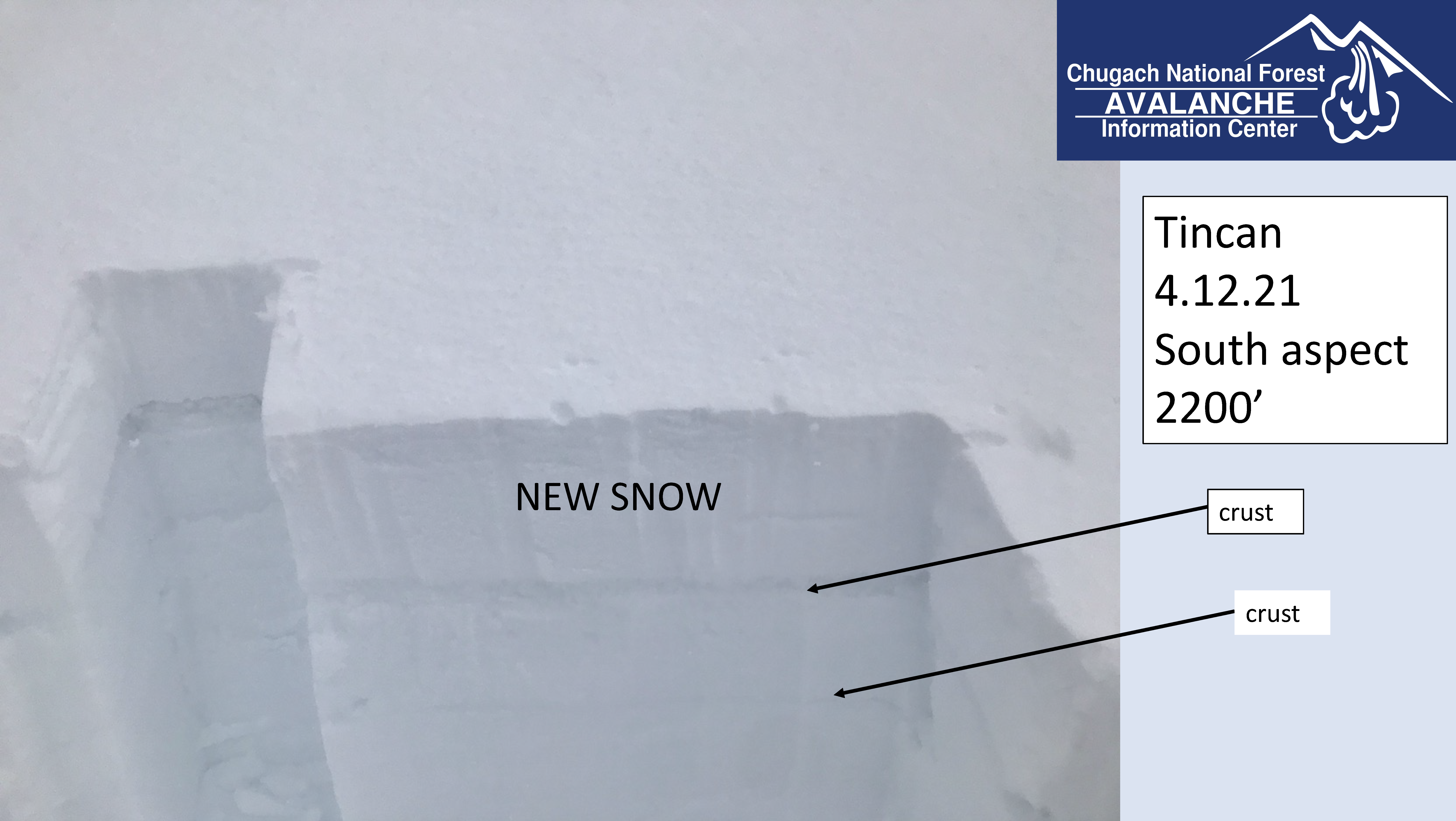
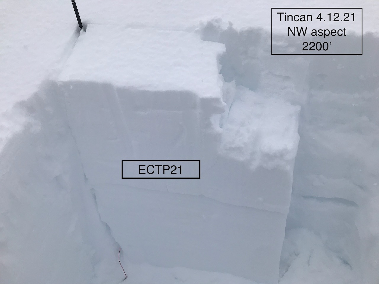
The avalanche danger is CONSIDERABLE at all elevations today. With fluctuating sky cover, increasing temperatures and wind speeds, natural avalanches are still possible today. Above 1000′ triggering a storm slab avalanche is likely in steep terrain. In addition, triggering an avalanche that steps down to a buried weak layer remains a concern. Below 1000′ triggering a wet loose avalanche is likely and slides from above may run into this elevation band. Give cornices a wide berth and avoid travel under glide cracks. Pay attention to changing conditions and look for signs of instability. Cautious route-finding and conservative decision-making are essential.
PORTAGE VALLEY: There is potential for avalanche debris, from a slide occurring above, to run to low elevation terrain. Avoiding summer trails that run through avalanche runout zones, such as Byron Glacier trail, is recommended through this coming weekend.
Roof Avalanches: Rain and warmer temperatures could cause roofs to shed their snow. Pay special attention to children, pets and where you park your car.
From Alaska Department of Transportation and Public Facilities: There will be intermittent traffic delays for avalanche hazard reduction today, April 13, 2021 on the Seward Highway from mile post 88 to 83 south of Girdwood from 11:00 am to 3:00 pm. There will also be delays on the Portage Glacier Highway today, April 13, 2021 for avalanche hazard reduction near Mile Post 5 and Bear Valley from 12:00 pm to 4:00 pm. Motorists should expect delays of 45 minutes. Updates will be posted on the 511 system. http://511.alaska.gov/
CNFAIC End Of Season Operations: Daily avalanche forecasts will continue through this weekend due to the weather forecast and elevated avalanche danger. We plan on switching to 4 days/week (Tues, Thur, Sat, Sun) beginning the Tuesday the 20th as our forecast season and funding winds down but that is still TBD. Stay tuned!
Signal Word | Size (D scale) | Simple Descriptor |
Small | 1 | Unlikely to bury a person |
Large | 2 | Can bury a person |
Very Large | 3 | Can destroy a house |
Historic | 4 & 5 | Can destroy part or all of a village |
After the Sunday afternoon into Monday storm brought 12-20+ inches of snow to the forecast area, we have a pretty interesting and variable springtime avalanche situation (as the late DMX used to say) ‘Up in here. Up in here!’ As mentioned above in Recent Avalanches there were avalanches observed yesterday. There is the potential to trigger one or for a natural avalanche to occur today, despite the lull in the weather before the next storm comes in this evening. If you are thinking of heading out today there are a number of things to keep in mind.
Pay attention to changing conditions. Are the winds increasing? Is it getting sunny for a bit? Is it really warm? Are you seeing signs of instability like cracking, collapsing or recent avalanches? Today is a day for choosing terrain very carefully.
Wind Slabs: With the strong easterly winds that occurred during the storm expect more slab development in the higher terrain. Watching for cracks that shoot out from your skis or machine and stiffer snow over softer snow.
Cornices: Moist snow and strong winds are the perfect recipe for cornice formation and growth. Expect these to still be sensitive today. Give cornices a wide berth. Triggering a cornice fall could trigger an avalanche on the slope below.
Signal Word | Size (D scale) | Simple Descriptor |
Small | 1 | Unlikely to bury a person |
Large | 2 | Can bury a person |
Very Large | 3 | Can destroy a house |
Historic | 4 & 5 | Can destroy part or all of a village |
New snow, wind loading and warmer temperatures are all factors that can contribute to activating the buried weak layers in the top 3 feet of the snowpack that we have been talking about for long time. Triggering an avalanche in the new snow could step down to one of these layers and create a larger avalanche. The Crow Pass and Raggedtop area near Girdwood is a suspect region and has seen this occur over the past few weeks. Additionally, this is especially likely in Summit Lake south of Turnagain Pass, where there is an overall thinner snowpack with more advanced weak layers. Summit Lake did not see much snowfall during this storm, but the area did get strong winds and warming temperatures yesterday.
A layer of buried surface hoar and small facets was propagating in an Extended Column Test in a snow pit on Tincan yesterday, 4.12.21. This illustrates the potential for an avalanche to step down to a buried weak layer.
Yesterday: Mostly cloudy skies with some pockets of sunshine. Snow/rain showers on and off throughout the day with precipitation favoring Girdwood and Portage. High temperatures in the mid 20°Fs in the alpine and 30°Fs and 40°Fs in the mid to low elevations. Winds were easterly, 20-30 mph with gusts into the 40s and 50s, decreasing in the afternoon. Overnight skies were cloudy and temperatures were in the mid 20°Fs to mid 30°Fs. Winds were mostly light and easterly.
Today: Mostly cloudy skies with a light precipitation during the day increasing tonight. Rain/snowline around 800′ today dropping back down to 300′ tonight. Snow could be heavy at times overnight. Temperatures today in the mid 20°Fs to low 40°Fs depending on elevation with southeast winds 5-15 mph with gusts into the 20s. East winds this evening, 15-25 mph with gusts into the 30s increasing overnight to 30-40 mph with gusts into the 70s, peaking early Wednesday morning.
Tomorrow: Snow and rain likely. Highs in the 30°Fs and 40°Fs (maybe the 50°Fs) with snow levels forecast to rise to as high as 1800′. Easterly winds 25-45 mph with gust into the 60s, decreasing as the day progresses. Precipitation eases up Wednesday night. The warm temperatures look like they stick around into the weekend with some sunshine in the forecast as well.
PRECIPITATION 24-hour data (6am – 6am)
Temp Avg (F) | Snow (in) | Water (in) | Snow Depth (in) | |
---|---|---|---|---|
Center Ridge (1880′) | 32 | 0 | 0.3 | 110 |
Summit Lake (1400′) | 33 | 0 | 0.1 | 46 |
Alyeska Mid (1700′) | 32 | 3.5 | 0.58 | 129 |
RIDGETOP 24-hour data (6am – 6am)
Temp Avg (F) | Wind Dir | Wind Avg (mph) | Wind Gust (mph) | |
---|---|---|---|---|
Sunburst (3812′) | 22 | NE | 16 | 59 |
Seattle Ridge (2400′) | 26 | E* | 14* | 27* |
*Seattle Ridge wind sensor likely rimed over around 5 pm yesterday. All wind data is from prior to that time.
Date | Region | Location | Observer |
---|---|---|---|
05/22/23 | Turnagain | Avalanche: Tincan | Nick D'Alessio |
05/12/23 | Turnagain | Avalanche: Tincan, Sunburst, Magnum, Cornbiscuit | Heather Thamm |
05/07/23 | Turnagain | Observation: Tincan – Bear Tracks | CNFAIC Staff |
05/05/23 | Turnagain | Observation: Seattle Ridge | AS/ WW Forecaster |
05/02/23 | Turnagain | Observation: Cornbiscuit | Schauer/ Sturgess Forecaster |
05/02/23 | Turnagain | Observation: Seward Hwy Turnagain Pass | Joel Curtis |
04/30/23 | Turnagain | Observation: Magnum | Ayla, Kit Crosby, Barton |
04/29/23 | Turnagain | Observation: Tincan | John Sykes |
04/28/23 | Turnagain | Avalanche: Taylor Pass/Pastoral | Schauer/ Creighton Forecaster |
04/28/23 | Turnagain | Avalanche: Tincan | Andy Moderow |
Status of riding areas across the Chugach NF is managed by the Glacier and Seward Ranger Districts, not avalanche center staff. Riding area information is posted as a public service to our users and updated based on snow depth and snow density to prevent resource damage at trailhead locations. Riding area questions contact: mailroom_r10_chugach@fs.fed.us
Area | Status | Weather & Riding Conditions |
---|---|---|
Glacier District |
Subscribe to Turnagain Pass
Avalanche Forecast by Email
This is a general backcountry avalanche advisory issued for Turnagain Arm with Turnagain Pass as the core advisory area. This advisory does not apply to highways, railroads or operating ski areas.