Turnagain Pass Avalanche Forecast RSS

Archives
ARCHIVED FORECAST - All forecasts expire after 24 hours from the posting date/time.
Issued
Thu, April 15th, 2021 - 7:00AM
Expires
Fri, April 16th, 2021 - 7:00AM
Forecaster
Andrew Schauer
Avalanche risk The Bottom Line

Today’s avalanche danger is CONSIDERABLE. It is likely a person will be able to trigger an avalanche 1′ deep or deeper in the heavy, wet snow that fell yesterday, and we may still see some natural activity. We saw rain as high as 1700’ yesterday and last night, and strong winds have been at work creating sensitive wind slabs at higher elevations. All of this recent precipitation and wind has applied a heavy load to persistent weak layers in the upper 3-4’ of the snowpack, creating dangerous avalanche conditions. Cautious route-finding will be key today as the snowpack adjusts to a major loading event and warm temperatures continue.

Special Announcements

Hatcher Pass: Be sure to check out the Hatcher Pass Avalanche Center’s Thursday report if you are planning on heading up that way. The road remains closed as DOT prepares for avalanche hazard reduction, which will be followed by clearing the road. More info at 511.alaska.gov.

Thanks to our sponsors!
Thu, April 15th, 2021
Alpine
Above 2,500'
Considerable (3)
Avalanche risk
Treeline
1,000'-2,500'
Considerable (3)
Avalanche risk
Below Treeline
Below 1,000'
Considerable (3)
Avalanche risk
Alpine
Above 2,500'
Avalanche risk
Considerable (3)
Treeline
1,000'-2,500'
Avalanche risk
Considerable (3)
Below Treeline
Below 1,000'
Avalanche risk
Considerable (3)
Danger Scale:
No Rating (0)
Low (1)
Moderate (2)
Considerable (3)
High (4)
Extreme (5)
Recent Avalanches

Seward Highway: Several large natural avalanches ran yesterday morning along the Seward Highway near Girdwood.

Seattle Ridge: Debris from another round of natural activity was visible from the road along Seattle Ridge. Most of the avalanches appeared to be loose wet avalanches, but some debris piles were wide enough that they likely came from wet slab avalanches.

Fresh avalanche debris along the Seward Hwy near Girdwood yesterday. Photo: Matt McKee. 04.14.2021

Avalanche Problem 1
  • Wet Slab
    Wet Slab
  • Almost Certain
    Very Likely
    Likely
    Possible
    Unlikely
    Likelihood
  • Historic (D4-5)
    Very Large (D3)
    Large (D2)
    Small (D1)
    Size
Wet Slab
Wet Slab avalanches are the release of a cohesive layer of snow (a slab) that is generally moist or wet when the flow of liquid water weakens the bond between the slab and the surface below (snow or ground). They often occur during prolonged warming events and/or rain-on-snow events. Wet Slabs can be very unpredictable and destructive.

Likelihood of Avalanches
Terms such as "unlikely", "likely", and "certain" are used to define the scale, with the chance of triggering or observing avalanches increasing as we move up the scale. For our purposes, "Unlikely" means that few avalanches could be triggered in avalanche terrain and natural avalanches are not expected. "Certain" means that humans will be able to trigger avalanches on many slopes, and natural avalanches are expected.

Size of Avalanches
Avalanche size is defined by the largest potential avalanche, or expected range of sizes related to the problem in question. Assigned size is a qualitative estimate based on the destructive classification system and requires specialists to estimate the harm avalanches may cause to hypothetical objects located in the avalanche track (AAA 2016, CAA 2014). Under this schema, "Small" avalanches are not large enough to bury humans and are relatively harmless unless they carry people over cliffs or through trees or rocks. Moving up the scale, avalanches become "Large" enough to bury, injure, or kill people. "Very Large" avalanches may bury or destroy vehicles or houses, and "Historic" avalanches are massive events capable of altering the landscape.

Signal Word Size (D scale) Simple Descriptor
Small 1 Unlikely to bury a person
Large 2 Can bury a person
Very Large 3 Can destroy a house
Historic 4 & 5 Can destroy part or all of a village
More info at Avalanche.org

Avalanche conditions are still dangerous today following heavy snowfall, strong winds, and rain up to around 1700′ yesterday. Since Monday evening, we have seen the following precipitation totals at weather stations in the area:

  • 15″ snow equaling 2.2″ snow water equivalent (SWE) at the Center Ridge Snotel station (el. 1880′)
  • 34″ snow equaling 3.7″ SWE at Alyeska’s mid-mountain station (el. 1700′)
  • 2″ snow equaling 0.7″ SWE at the Summit Lake Snotel station (el. 1400′)

With mixed rain and snow approaching these weather stations, we expect significantly higher storm totals at higher elevations. Snow surface conditions will change drastically with elevation today, but conditions will be dangerous from valleys to ridgelines. At lower to mid elevations, the combination of rain on snow and over 24 hours of above-freezing temperatures will increase the likelihood of triggering wet snow avalanches. At elevations above 1700′, higher snow totals will make it possible to trigger larger avalanches. Strong winds through yesterday night have been creating wind slabs up to 2-3′ deep that will be sensitive to human triggers. Slab depth will increase with elevation, where storm totals and wind speeds were higher.

The avalanche conditions are complicated today, but the travel advice is simple: cautious route-finding and conservative decision-making are key. Whether you are dealing with a wet slab, a wind slab, or a storm slab, it is likely a person can trigger an avalanche in terrain 35 degrees or steeper today. With all of the recent snow, avalanches can be large today and have the potential to run into lower elevations. This means it will also be important to be aware of the avalanche hazard from steep slopes above you.

As we head into the weekend, we are expecting to see sunny skies and the warmest temperatures of the season. This is going to result in elevated avalanche danger for the next few days as the snowpack heats up and we start to see things falling apart. Be sure to stay tuned for updates as we head into what is feeling a lot more like springtime.

Loose snow avalanches: It is very likely a person will be able to trigger loose snow avalanches in steep terrain today. These may be dry at higher elevations and wet at lower elevations. Be on the lookout for natural activity as well, especially if the sun pokes through the clouds later in the day.

Roof avalanches: Some buildings in Girdwood have already been seeing the massive piles of snow slide off of their roofs with warm temperatures and rain in town. This will continue to be a hazard today, so be sure to keep an eye on kids and pets, and be careful where you park your car.

Debris from natural avalanches above the Bertha Creek campground on Tuesday. Photo taken 04.14.2021.

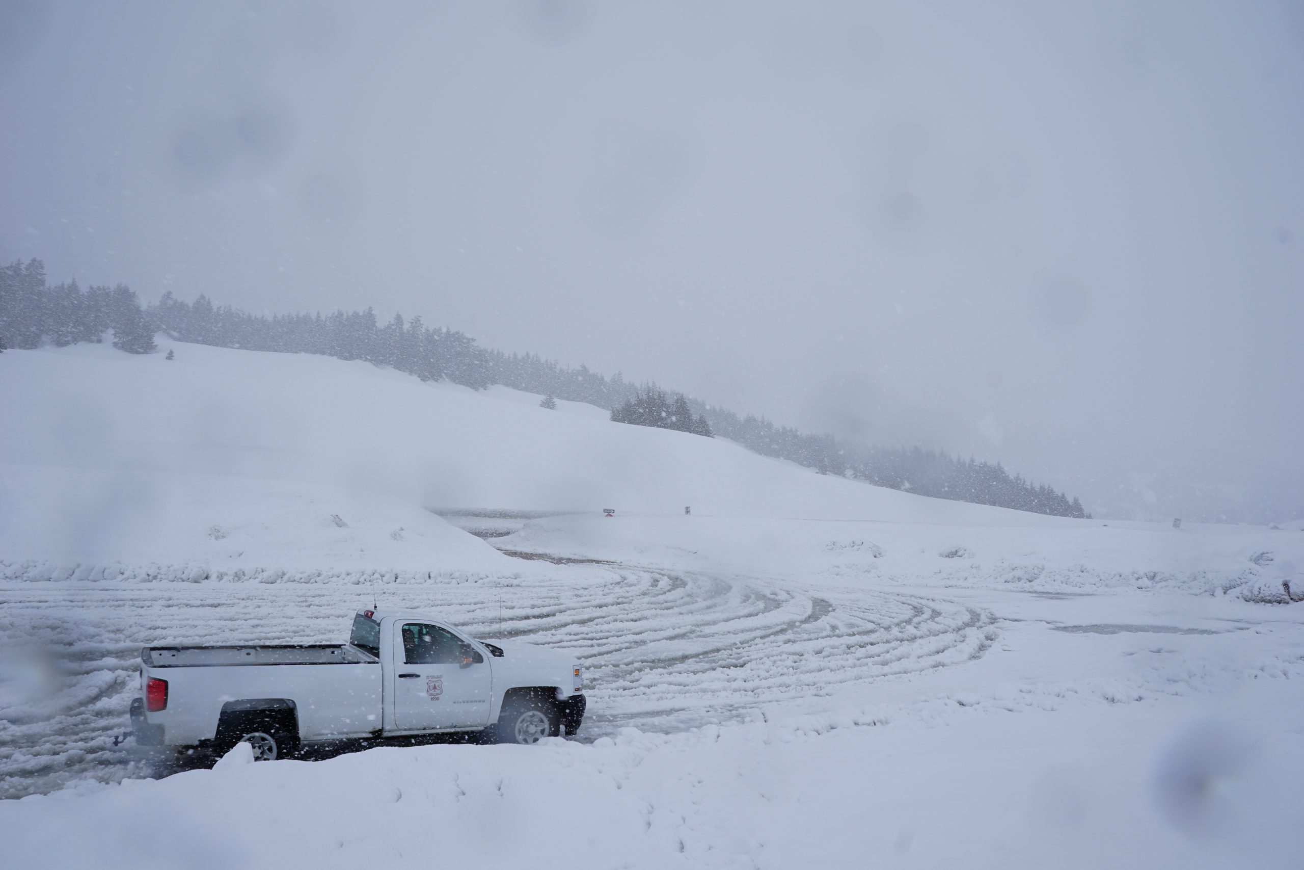
Very soggy conditions at the top of Turnagain Pass yesterday. The snow turned into rain shortly after the picture was taken. 04.14.2021

Avalanche Problem 2
  • Persistent Slabs
    Persistent Slabs
  • Almost Certain
    Very Likely
    Likely
    Possible
    Unlikely
    Likelihood
  • Historic (D4-5)
    Very Large (D3)
    Large (D2)
    Small (D1)
    Size
Persistent Slabs
Persistent Slab avalanches are the release of a cohesive layer of snow (a slab) in the middle to upper snowpack, when the bond to an underlying persistent weak layer breaks. Persistent layers include: surface hoar, depth hoar, near-surface facets, or faceted snow. Persistent weak layers can continue to produce avalanches for days, weeks or even months, making them especially dangerous and tricky. As additional snow and wind events build a thicker slab on top of the persistent weak layer, this avalanche problem may develop into a Deep Persistent Slab.

Likelihood of Avalanches
Terms such as "unlikely", "likely", and "certain" are used to define the scale, with the chance of triggering or observing avalanches increasing as we move up the scale. For our purposes, "Unlikely" means that few avalanches could be triggered in avalanche terrain and natural avalanches are not expected. "Certain" means that humans will be able to trigger avalanches on many slopes, and natural avalanches are expected.

Size of Avalanches
Avalanche size is defined by the largest potential avalanche, or expected range of sizes related to the problem in question. Assigned size is a qualitative estimate based on the destructive classification system and requires specialists to estimate the harm avalanches may cause to hypothetical objects located in the avalanche track (AAA 2016, CAA 2014). Under this schema, "Small" avalanches are not large enough to bury humans and are relatively harmless unless they carry people over cliffs or through trees or rocks. Moving up the scale, avalanches become "Large" enough to bury, injure, or kill people. "Very Large" avalanches may bury or destroy vehicles or houses, and "Historic" avalanches are massive events capable of altering the landscape.

Signal Word Size (D scale) Simple Descriptor
Small 1 Unlikely to bury a person
Large 2 Can bury a person
Very Large 3 Can destroy a house
Historic 4 & 5 Can destroy part or all of a village
More info at Avalanche.org

The combination of heavy snowfall, strong winds, and rain has applied a load that will test the strength of the buried persistent weak layers that we have been dealing with for some time now. With a weak refreeze overnight, we are likely to see additional meltwater moving through the snowpack, further contributing to poor stability. Avalanches triggered at the new/old snow interface (see Problem 1 above) will have the potential to step down to these deeper weak layers, creating larger avalanches. The potential for these persistent slab avalanches is just one more reason to avoid steep terrain today, and be mindful of crossing runout zones below steep avalanche paths above.

Weather
Thu, April 15th, 2021

Yesterday: Heavy snowfall and rain brought a foot or  more new snow to upper elevations near Girdwood, and 6-12″ at Turnagain Pass. Rain made it up to around 1700′, with high temperatures in the upper 20’s F near ridgetops in the upper 30’s to low 40’s F in the valleys. Winds were strong out of the east at 20-45 mph with gusts near 60 mph.

Today: Precipitation is expected to taper off during the day today, bringing another 3-6″ snow near Girdwood and 1-2″ at Turnagain Pass. The rain level could make it as high as 2200′ during the day. High temperatures are expected in the low to upper 30’s F today, with overnight lows in the low to mid 20’s F. Easterly winds are expected to calm down during the day, starting at 25-30 mph this morning and decreasing to 10-15 mph this afternoon.

Tomorrow: Clouds are expected to begin to break up overnight, with partly sunny skies during the day tomorrow. Highs are going to climb into the low 30’s to low 40’s F with a light easterly breeze. No precipitation is expected. This will be the start to a warm and sunny weekend, which is going to make for dangerous conditions. Be sure to stay tuned for more updates.

PRECIPITATION 24-hour data (6am – 6am)

Temp Avg (F) Snow (in) Water (in) Snow Depth (in)
Center Ridge (1880′) 35 6 0.9 116
Summit Lake (1400′) 37 1 0.3 45
Alyeska Mid (1700′) 33 11 1.9 135

RIDGETOP 24-hour data (6am – 6am)

Temp Avg (F) Wind Dir Wind Avg (mph) Wind Gust (mph)
Sunburst (3812′) 24 ENE 29 58
Seattle Ridge (2400′) 28 SE* 12* 33*

*Seattle Ridge anemometer has been rime-covered since 3:00 a.m.

Observations
Recent Observations for Turnagain Pass
Date Region Location
03/26/23 Turnagain Avalanche: Sunburst avalanche investigation
03/26/23 Turnagain Observation: Magnum shoulder
03/25/23 Turnagain Avalanche: Seattle Ridge backside – several human triggered large avalanches
03/25/23 Turnagain Avalanche: Seattle Ridge, 3rd Bowl, Rider Triggered Avalanches
03/25/23 Turnagain Avalanche: Pastoral
03/25/23 Turnagain Avalanche: Eddie’s
03/25/23 Turnagain Observation: Eddies lower slopes
03/25/23 Turnagain Observation: Sunny Side
03/24/23 Turnagain Avalanche: Sunburst/Magnum
03/23/23 Turnagain Avalanche: Magnum
Riding Areas
Updated Fri, February 10th, 2023

Status of riding areas across the Chugach NF is managed by the Glacier and Seward Ranger Districts, not avalanche center staff. Riding area information is posted as a public service to our users and updated based on snow depth and snow density to prevent resource damage at trailhead locations. Riding area questions contact: mailroom_r10_chugach@fs.fed.us

Area Status Weather & Riding Conditions
Glacier District
Johnson Pass
Open
Opened Dec 13th.
Placer River
Open
Closed Jan 5th due to lack of snow and reopened Feb 11th.
Skookum Drainage
Open
Closed Jan 5th due to lack of snow and reopened Feb 11th.
Turnagain Pass
Open
Opened Dec 13th.
Twentymile
Open
Closed Jan 5th due to lack of snow and reopened Feb 11th.
Seward District
Carter Lake
Open
Opened Dec 13th.
Lost Lake Trail
Open
Opened Dec 13th.
Primrose Trail
Open
Opened Dec 13th.
Resurrection Pass Trail
Closed
Closed to motorized use for the 2022/23 winter season per Forest Plan. Open next season.
Snug Harbor
Open
Opened Dec 13th.
South Fork Snow River Corridor
Open
Opened Dec 13th.
Summit Lake
Open
Opened Dec 13th.

Subscribe to Turnagain Pass
Avalanche Forecast by Email

This is a general backcountry avalanche advisory issued for Turnagain Arm with Turnagain Pass as the core advisory area. This advisory does not apply to highways, railroads or operating ski areas.