Turnagain Pass Avalanche Forecast
|
![]() ![]() |
A CONSIDERABLE avalanche danger exists above 2,500′ and MODERATE danger below 2,500′. Many different kinds of avalanches could be triggered today. These are wind slabs up to 2 feet deep above treeline, which should be the most likely due to yesterday’s winds. The others are storm slabs between 10-20″ deep in areas without wind loading, sluffs on steep slopes, and cornice falls.
Daytime warming this afternoon/evening could initiate wet loose avalanches at all elevations. Warming can also cause all the above types of avalanches to become easier to trigger. A cautious mindset and paying close attention to signs of instability is recommended.
Hatcher Pass Avalanche Center: Check out the HPAC forecast for today – up to 21″ of new snow with more expected. Dangerous avalanche conditions.
Avalanche Center End of Season Operations: This is our last week of 7 day/week forecasting. Beginning April 17 we will forecast 4 days/week (Tuesday, Thursday, Saturday Sunday). The final forecast is scheduled for April 30th.
We’re looking for your input! We’ve made some changes to the forecast and are curious to hear if it worked. This is your chance to give us feedback that will help us continue to improve our forecasts. We’ve put together a quick survey that should take 5-10 minutes. If you haven’t yet, please Click here. Big thanks to everyone who has responded! It’s great to get so much feedback from the community.
No new avalanches were seen or reported yesterday. However, there was relatively little backcountry traffic and poor visibility. The last know avalanches were on Sunday and Monday when people found reactive storm slabs within the new snow (~10-14″ at Turnagain). The sun also induced some storm slabs on Monday afternoon due to warming.
Example of one of the smallish storm slabs triggered on Monday. This was on Tincan. Photo by Mike Records 4.10.23.
Signal Word | Size (D scale) | Simple Descriptor |
Small | 1 | Unlikely to bury a person |
Large | 2 | Can bury a person |
Very Large | 3 | Can destroy a house |
Historic | 4 & 5 | Can destroy part or all of a village |
Snowfall overnight and this morning has added another 3-6″ of new snow, possibly more in favor areas like Portage and Placer Valleys. Turnagain Pass may have only received 1-2″. The snow has come in with relatively light easterly winds along the ridgetops and is making its way to sea level. Light snow showers may continue until around noon with little additional accumulation.
The avalanche problem ‘icon’ above may say storm slab, but really there are all kinds of avalanche problems to be on the lookout for. The most concerning will be higher elevations that saw wind loading yesterday. Wind slabs up to 2′ deep formed by yesterday’s bump in easterly winds, gusting in the 30’smph, could be found and triggered by us. These could be obscured by the light snow from overnight. There could also be some storm slabs lingering in areas out of the winds that are sitting on a crust from early April. Loose snow sluffs will probably be easy for us to trigger on steep slopes and cornices could be teetering close to failure. It is a day to really pay attention to the surface conditions and the Red Flags (recent avalanches, cracking in the snow around us and collapsing/whumpfing in the snow under us.
Daytime warming and avalanches possible in the afternoon: This afternoon if the clouds break and the sun peaks through, we could see some naturally triggered avalanches in the storm snow from last night as well as that from over the weekend. Look for loose snow sluffs and shallow slabs as the surface snow heats up later today. These could be triggered by us, or naturally. As is often the case, a smallish sluff can trigger a slab making for a larger avalanche.
Snowpack in the Placer Valley area. More snow fell here than at Turnagain. The storm snow in the lower elevations is stabilizing, but much more uncertainly exists in the higher elevations. 4.12.23.
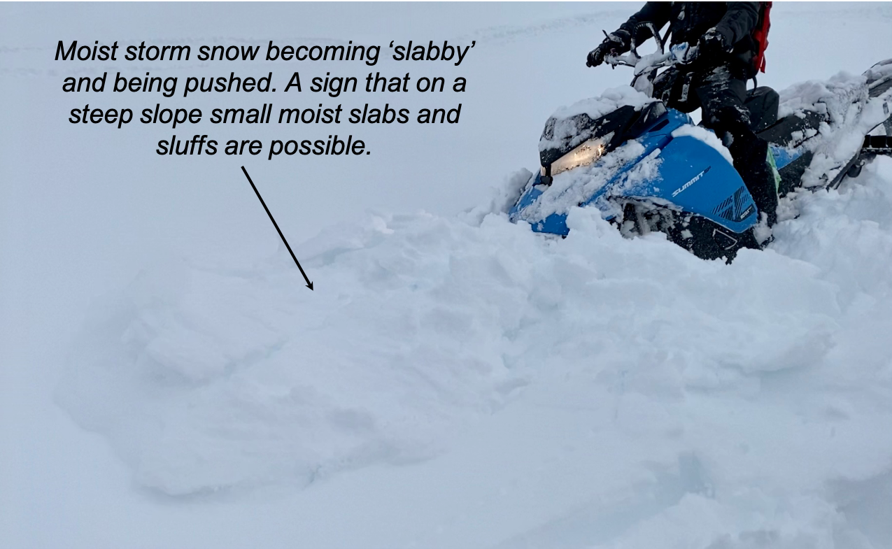
Example of the surface snow heating up and becoming sticky – and what we call ‘slabby’. This is a red flag for creating larger sluffs and slabs in steep terrain due to warming of otherwise loose and dry storm snow. 4.11.23.
In addition to the concerns related to the new snow mentioned above, we still want people to remember there is a small likelihood of triggering a very big avalanche. This would be on weak snow that was buried in mid March and is 3-6′ deep. It has now been over two weeks since we last saw the last deep slab avalanche. We have been tracking the weak layer in snowpits for nearly a month, and although it is showing signs of gaining strength we don’t totally trust it. To avoid the problem, limiting traveling on or below steep slopes. As time goes on this type of avalanche is becoming less and less likely, but we shouldn’t forget about it yet.
Yesterday: Cloudy and obscured skies with some afternoon light snowfall was over the region. Ridgetop winds were blustery, 10-20mph with gusts over 30mph. Snowfall picked up overnight and 2-5″ looks have accumulated by 6am this morning, to see level.
Today: Light snowfall should continue until around noon with another 1-2″ of snow accumulation. Skies could break a bit this afternoon allowing for the daytime warming to bump close to 40F in the parking lots and near 30F along ridgelines. Ridgetop winds have quieted overnight and should be light and variable through the day.
Tomorrow: Partly to mostly cloudy skies are expected tomorrow, Thursday, before another round of snow hits on Friday. Winds are expected to be light and easterly before picking up tomorrow night as well. Temperatures should remain on the cooler side, generally in the 20’sF.
PRECIPITATION 24-hour data (6am – 6am)
Temp Avg (F) | Snow (in) | Water (in) | Snow Depth (in) | |
---|---|---|---|---|
Center Ridge (1880′) | 28 | 2 | 0.1 | 96 |
Summit Lake (1400′) | 25 | 3 | 0.2 | 50 |
Alyeska Mid (1700′) | 27 | 6 | 0.4 | 94 |
Bear Valley – Portage (132′) | 34 | 5 | 0.4 | – |
RIDGETOP 24-hour data (6am – 6am)
Temp Avg (F) | Wind Dir | Wind Avg (mph) | Wind Gust (mph) | |
---|---|---|---|---|
Sunburst (3812′) | 16 | ENE | 13 | 33 |
Seattle Ridge (2400′) | 21 | SE | 12 | 20 |
Date | Region | Location | Observer |
---|---|---|---|
05/22/23 | Turnagain | Avalanche: Tincan | Nick D'Alessio |
05/12/23 | Turnagain | Avalanche: Tincan, Sunburst, Magnum, Cornbiscuit | Heather Thamm |
05/07/23 | Turnagain | Observation: Tincan – Bear Tracks | CNFAIC Staff |
05/05/23 | Turnagain | Observation: Seattle Ridge | AS/ WW Forecaster |
05/02/23 | Turnagain | Observation: Cornbiscuit | Schauer/ Sturgess Forecaster |
05/02/23 | Turnagain | Observation: Seward Hwy Turnagain Pass | Joel Curtis |
04/30/23 | Turnagain | Observation: Magnum | Ayla, Kit Crosby, Barton |
04/29/23 | Turnagain | Observation: Tincan | John Sykes |
04/28/23 | Turnagain | Avalanche: Taylor Pass/Pastoral | Schauer/ Creighton Forecaster |
04/28/23 | Turnagain | Avalanche: Tincan | Andy Moderow |
Status of riding areas across the Chugach NF is managed by the Glacier and Seward Ranger Districts, not avalanche center staff. Riding area information is posted as a public service to our users and updated based on snow depth and snow density to prevent resource damage at trailhead locations. Riding area questions contact: mailroom_r10_chugach@fs.fed.us
Area | Status | Weather & Riding Conditions |
---|---|---|
Glacier District |
Subscribe to Turnagain Pass
Avalanche Forecast by Email
This is a general backcountry avalanche advisory issued for Turnagain Arm with Turnagain Pass as the core advisory area. This advisory does not apply to highways, railroads or operating ski areas.