Turnagain Pass Avalanche Forecast RSS

Archives
ARCHIVED FORECAST - All forecasts expire after 24 hours from the posting date/time.
Issued
Tue, April 11th, 2023 - 7:00AM
Expires
Wed, April 12th, 2023 - 7:00AM
Forecaster
Andrew Schauer
Avalanche risk The Bottom Line

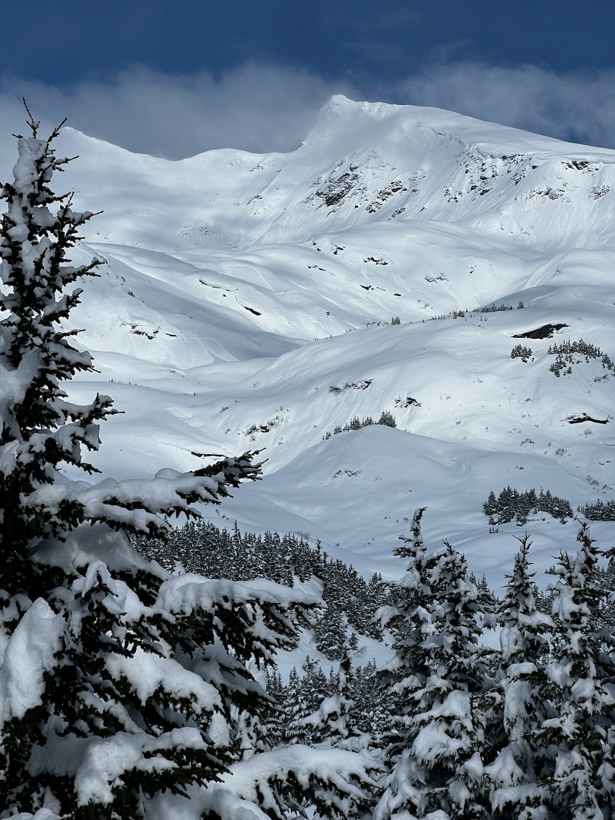
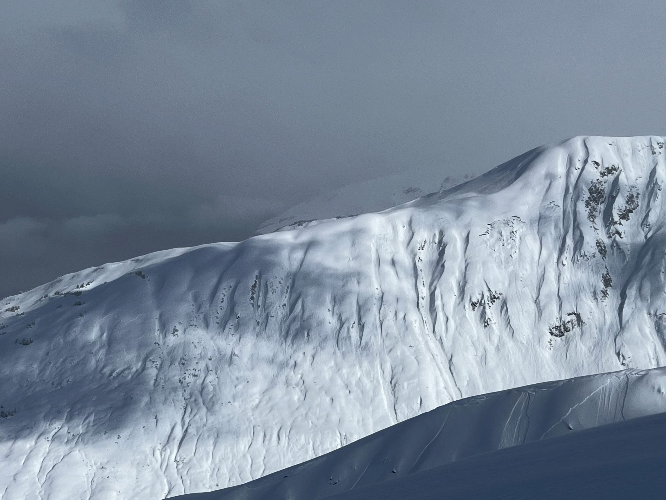
The avalanche danger remains CONSIDERABLE at all elevations today. The most recent storm has dropped 1-3′ of low-density snow since Sunday, and it is likely a person will be able to trigger an avalanche within all of that new snow today. Be on the lookout for increasing chances of triggering an avalanche as the weather picks up later in the day, with another round of wind and light snowfall expected starting this afternoon.

Special Announcements

We’re looking for your input! We’ve made some changes to the forecast this year, and we are curious to hear how well it has worked. This is your chance to give us some feedback that will help us continue to improve our forecasts. These advisories are for you and we want to know how we can make them better. We’ve put together a quick survey that should take 5-10 minutes to complete. If you have a chance, please Click here for the survey. Big thanks to all of the folks who have already responded! It’s great to get so much feedback from the community.

Thanks to our sponsors!
Tue, April 11th, 2023
Alpine
Above 2,500'
Considerable (3)
Avalanche risk
Treeline
1,000'-2,500'
Considerable (3)
Avalanche risk
Below Treeline
Below 1,000'
Considerable (3)
Avalanche risk
Alpine
Above 2,500'
Avalanche risk
Considerable (3)
Treeline
1,000'-2,500'
Avalanche risk
Considerable (3)
Below Treeline
Below 1,000'
Avalanche risk
Considerable (3)
Danger Scale:
No Rating (0)
Low (1)
Moderate (2)
Considerable (3)
High (4)
Extreme (5)
Recent Avalanches

We saw widespread natural storm slab activity yesterday, especially when the sun came out in the afternoon. Multiple parties reported touchy storm snow that was reactive to ski and snowmachine cuts with limited propagation for the most part.

Multiple natural storm slab avalanches near Johnson Pass. Photo submitted anonymously, 04.10.2023


Avalanche Problem 1
  • Storm Slabs
    Storm Slabs
  • Aspect/Elevation
  • Almost Certain
    Very Likely
    Likely
    Possible
    Unlikely
    Likelihood
  • Historic (D4-5)
    Very Large (D3)
    Large (D2)
    Small (D1)
    Size
Storm Slabs
Storm Slab avalanches are the release of a cohesive layer (a slab) of new snow that breaks within new snow or on the old snow surface. Storm-slabs typically last between a few hours and few days (following snowfall). Storm-slabs that form over a persistent weak layer (surface hoar, depth hoar, or near-surface facets) may be termed Persistent Slabs or may develop into Persistent Slabs.

Aspect/Elevation of the Avalanche Problem
Specialists develop a graphic representation of the potential distribution of a particular avalanche problem across the topography. This aspect/elevation rose is used to indicate where the particular avalanche problem is thought to exist on all elevation aspects. Areas where the avalanche problem is thought to exist are colored grey, and it is less likely to be encountered in areas colored white.

Likelihood of Avalanches
Terms such as "unlikely", "likely", and "certain" are used to define the scale, with the chance of triggering or observing avalanches increasing as we move up the scale. For our purposes, "Unlikely" means that few avalanches could be triggered in avalanche terrain and natural avalanches are not expected. "Certain" means that humans will be able to trigger avalanches on many slopes, and natural avalanches are expected.

Size of Avalanches
Avalanche size is defined by the largest potential avalanche, or expected range of sizes related to the problem in question. Assigned size is a qualitative estimate based on the destructive classification system and requires specialists to estimate the harm avalanches may cause to hypothetical objects located in the avalanche track (AAA 2016, CAA 2014). Under this schema, "Small" avalanches are not large enough to bury humans and are relatively harmless unless they carry people over cliffs or through trees or rocks. Moving up the scale, avalanches become "Large" enough to bury, injure, or kill people. "Very Large" avalanches may bury or destroy vehicles or houses, and "Historic" avalanches are massive events capable of altering the landscape.

Signal Word Size (D scale) Simple Descriptor
Small 1 Unlikely to bury a person
Large 2 Can bury a person
Very Large 3 Can destroy a house
Historic 4 & 5 Can destroy part or all of a village
More info at Avalanche.org

Storm totals since Sunday range from 12-18″ near Girdwood and Turnagain Pass to 2-3′ near Portage and Placer. This was very low-density fluff that has bonded poorly to the old snow surfaces, with widespread natural activity yesterday. Given the low density of the storm snow and the mixed bag of weak surfaces that it fell on, there is some uncertainty as to how quickly this round of new snow instabilities will heal. We are expecting to find poor stability continuing today, and human triggered avalanches 1-3′ deep remain likely. With winds picking up throughout the day, we will be on the lookout for fresh wind slabs forming this afternoon. It is looking like the strong southeasterly winds may reach down into the lower elevations. With all of this light fluffy snow on the ground, it won’t take much wind to start building fresh slabs.

Safe travel today will require a cautious mindset. Expect to find reactive snow, and be extra cautious around steep terrain. These new snow instabilities tend to give warning signs like shooting cracks when conditions are dangerous. These are the kind of problems that can be assessed with small test slopes to see how the new snow is behaving. For slopes without a cohesive slab of snow on top, we should be on the lookout for dry loose avalanches that will be eager to release on top of the old snow surfaces. With another pulse of snow and wind on the way this afternoon and tonight, expect to see dangerous avalanche conditions continue into the week.

There’s a snowmachine parked in there somewhere… Photo taken in the Placer Valley yesterday. 04.10.2023

Widespread natural activity on the south side of Eddies, with some storm slabs and point releases off the skier’s right flank of Todd’s run in the foreground. 04.10.2023

Avalanche Problem 2
  • Deep Persistent Slabs
    Deep Persistent Slabs
  • Aspect/Elevation
  • Almost Certain
    Very Likely
    Likely
    Possible
    Unlikely
    Likelihood
  • Historic (D4-5)
    Very Large (D3)
    Large (D2)
    Small (D1)
    Size
Deep Persistent Slabs
Deep Persistent Slab avalanches are the release of a thick cohesive layer of hard snow (a slab), when the bond breaks between the slab and an underlying persistent weak layer deep in the snowpack. The most common persistent weak layers involved in deep, persistent slabs are depth hoar or facets surrounding a deeply buried crust. Deep Persistent Slabs are typically hard to trigger, are very destructive and dangerous due to the large mass of snow involved, and can persist for months once developed. They are often triggered from areas where the snow is shallow and weak, and are particularly difficult to forecast for and manage.

Aspect/Elevation of the Avalanche Problem
Specialists develop a graphic representation of the potential distribution of a particular avalanche problem across the topography. This aspect/elevation rose is used to indicate where the particular avalanche problem is thought to exist on all elevation aspects. Areas where the avalanche problem is thought to exist are colored grey, and it is less likely to be encountered in areas colored white.

Likelihood of Avalanches
Terms such as "unlikely", "likely", and "certain" are used to define the scale, with the chance of triggering or observing avalanches increasing as we move up the scale. For our purposes, "Unlikely" means that few avalanches could be triggered in avalanche terrain and natural avalanches are not expected. "Certain" means that humans will be able to trigger avalanches on many slopes, and natural avalanches are expected.

Size of Avalanches
Avalanche size is defined by the largest potential avalanche, or expected range of sizes related to the problem in question. Assigned size is a qualitative estimate based on the destructive classification system and requires specialists to estimate the harm avalanches may cause to hypothetical objects located in the avalanche track (AAA 2016, CAA 2014). Under this schema, "Small" avalanches are not large enough to bury humans and are relatively harmless unless they carry people over cliffs or through trees or rocks. Moving up the scale, avalanches become "Large" enough to bury, injure, or kill people. "Very Large" avalanches may bury or destroy vehicles or houses, and "Historic" avalanches are massive events capable of altering the landscape.

Signal Word Size (D scale) Simple Descriptor
Small 1 Unlikely to bury a person
Large 2 Can bury a person
Very Large 3 Can destroy a house
Historic 4 & 5 Can destroy part or all of a village
More info at Avalanche.org

In addition to the concerns related to the new snow mentioned in Problem 1 above, we are still concerned with the smaller likelihood of a person triggering a huge avalanche on weak snow that was buried in the middle of March. This layer showed its potential for destructive avalanches, but it has now been over two weeks since we last saw an avalanche fail on it. We have been tracking the weak layer in snowpits for nearly a month now, and although it is showing signs of gaining strength we don’t trust it just yet. To avoid the problem entirely, avoid traveling on or below steep slopes. As time goes on this type of avalanche is becoming less and less likely, but we shouldn’t forget about it yet.

Weather
Tue, April 11th, 2023

Yesterday: Heavy snowfall continued until late morning, with spotty snow showers through the day. Weather stations picked up another 1-2” snow equaling 0.1-0.2” SWE since 6 a.m. yesterday. Winds were light out of the west in the morning, picking up and switching to the east at 10-15 mph with gusts of 20-30 mph during the afternoon. Clouds broke up in the afternoon, with some sun poking through. High temperatures were in the upper teens F at upper elevations and in the low 30’s F at low elevations. The coldest period in the past 24 hours was yesterday morning, with lows in the single digits F. Temperatures last night dropped into the upper teens to low 20’s F.

Today: The day should start off mostly cloudy with light winds out of the east. Winds will pick up to 15-20 mph gusting 20-30 mph through the afternoon, with snow returning later in the day. We may see a trace to 2” snow during the day today, with another 2-4” tonight. Temperatures will be in the low 20’s to 30 F today, dropping in the low to mid 20’s F tonight.

Tomorrow: Strong easterly winds are expected through tonight before switching to the southwest and calming down tomorrow, with average speeds around 5-10 mph and gusts of 10-15 mph. We may see a trace of snow in the morning before clouds try to start breaking up. High temperatures will be in the mid 20’s to mid 30’s F, with lows in the upper teens to mid 20’s F.

PRECIPITATION 24-hour data (6am – 6am)

Temp Avg (F) Snow (in) Water (in) Snow Depth (in)
Center Ridge (1880′) 24 1 0.1 98
Summit Lake (1400′) 21 0 0 47
Alyeska Mid (1700′) 23 2 0.13 91
Bear Valley – Portage (132′) 26 4 0.4

RIDGETOP 24-hour data (6am – 6am)

Temp Avg (F) Wind Dir Wind Avg (mph) Wind Gust (mph)
Sunburst (3812′) 13 E 8 31
Seattle Ridge (2400′) 17 SE 6 20
Observations
Recent Observations for Turnagain Pass
Date Region Location
05/22/23 Turnagain Avalanche: Tincan
05/12/23 Turnagain Avalanche: Tincan, Sunburst, Magnum, Cornbiscuit
05/07/23 Turnagain Observation: Tincan – Bear Tracks
05/05/23 Turnagain Observation: Seattle Ridge
05/02/23 Turnagain Observation: Cornbiscuit
05/02/23 Turnagain Observation: Seward Hwy Turnagain Pass
04/30/23 Turnagain Observation: Magnum
04/29/23 Turnagain Observation: Tincan
04/28/23 Turnagain Avalanche: Taylor Pass/Pastoral
04/28/23 Turnagain Avalanche: Tincan
Riding Areas
Updated Thu, June 01st, 2023

Status of riding areas across the Chugach NF is managed by the Glacier and Seward Ranger Districts, not avalanche center staff. Riding area information is posted as a public service to our users and updated based on snow depth and snow density to prevent resource damage at trailhead locations. Riding area questions contact: mailroom_r10_chugach@fs.fed.us

Area Status Weather & Riding Conditions
Glacier District
Johnson Pass
Closed
Closed May 15.
Placer River
Closed
Closed May 15.
Skookum Drainage
Closed
Will close to motorized use on April 1, 2023 per the National Forest Plan.
Turnagain Pass
Closed
Will close on June 1.
Twentymile
Closed
Scheduled closure May 1.
Seward District
Carter Lake
Closed
Scheduled closure May 1.
Lost Lake Trail
Closed
Scheduled closure May 1.
Primrose Trail
Closed
Scheduled closure May 1.
Resurrection Pass Trail
Closed
Closed to motorized use for the 2022/23 winter season per Forest Plan. Open next season.
Snug Harbor
Closed
Extended opening until May 15.
South Fork Snow River Corridor
Closed
Scheduled closure May 1.
Summit Lake
Closed
Scheduled closure May 1.

Subscribe to Turnagain Pass
Avalanche Forecast by Email

This is a general backcountry avalanche advisory issued for Turnagain Arm with Turnagain Pass as the core advisory area. This advisory does not apply to highways, railroads or operating ski areas.