Turnagain Pass Avalanche Forecast
|
![]() ![]() |
The avalanche danger is MODERATE at all elevations today. Our main concern is the possibility of triggering an avalanche 1-3′ deep in the new snow that has fallen since Sunday. The odds of triggering an avalanche will increase if the sun stays out later in the day before clouds start to build.
SEWARD/LOST LAKE: The latest round of snow buried a layer of surface hoar in the Seward area. This will make human-triggered avalanches likely, and extra caution is advised in these southern zones.
Hatcher Pass Avalanche Center: HIGH avalanche danger today for Hatcher Pass, see their Thursday forecast HERE. Danger avalanche conditions exist.
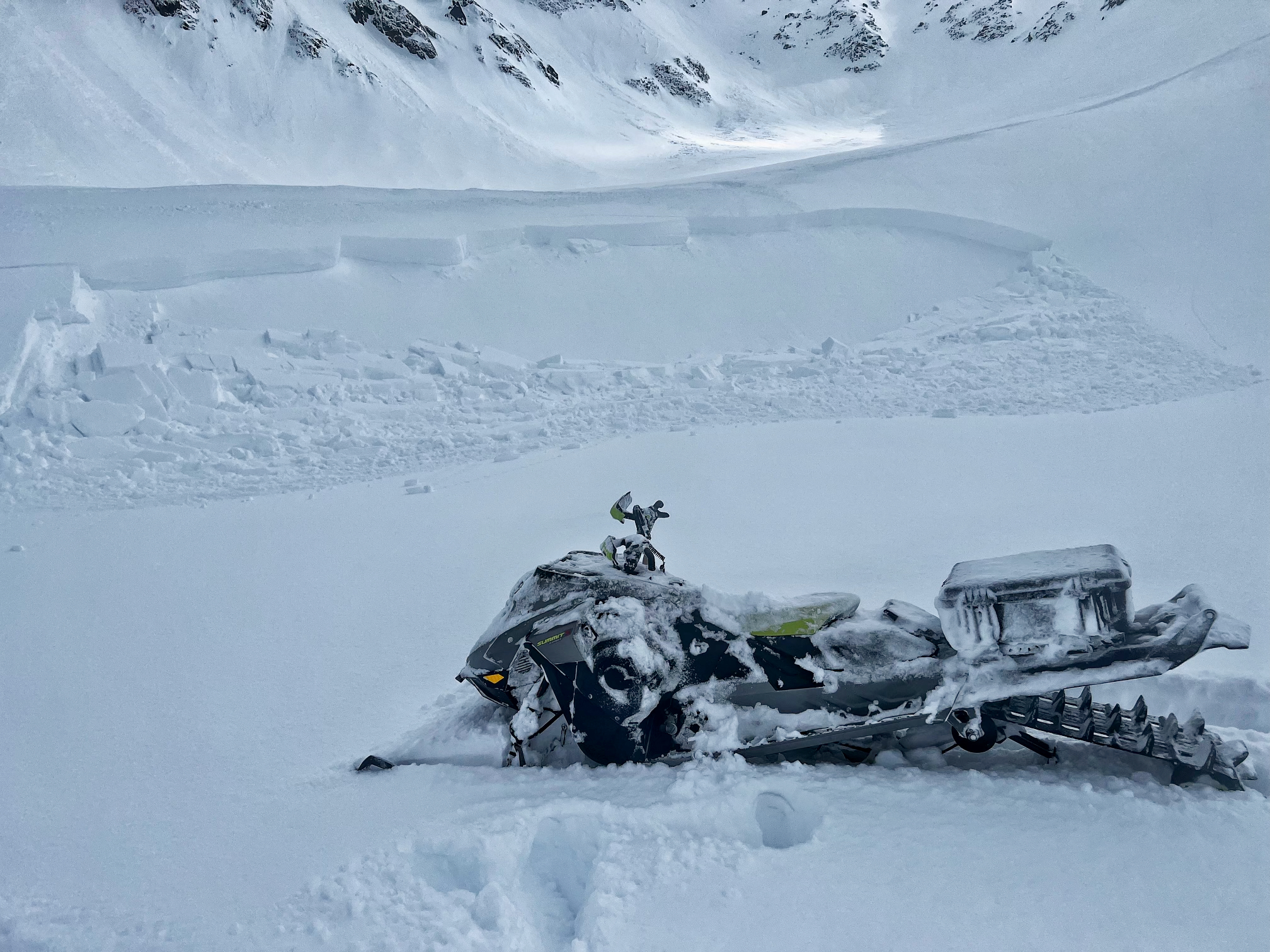
Chugach State Park: We have received multiple reports of human-triggered avalanches in the Front Range this week. Most of these appear to be failing at the new snow/old snow interface, and although there have been several near-misses, nobody has been caught or carried. Take a look at our observations page for more details.
Avalanche Center End of Season Operations: This is our last week of 7 day/week forecasting. Beginning April 17 we will forecast 4 days/week (Tuesday, Thursday, Saturday, Sunday). The final forecast is scheduled for April 30th.
We’re looking for your input! We’ve made some changes to the forecast and are curious to hear if it worked. This is your chance to give us feedback that will help us continue to improve our forecasts. We’ve put together a quick survey that should take 5-10 minutes. If you haven’t yet, please Click here. Big thanks to everyone who has responded! It’s great to get so much feedback from the community.
We saw multiple natural and human-triggered avalanches yesterday as the sun came out and warmed all of the storm snow that we’ve gotten this week. This includes a large avalanche near Johnson Pass/Bench Peak, which was up to 7′ deep and most likely only involved new and wind-loaded snow, a skier-triggered avalanche on Tincan’s Common Bowl, and a small snowmachine-triggered avalanche in the Placer Valley. We also saw many wet loose avalanches releasing as things heated up yesterday.
It’s a little misleading in the photo, but that crown in the background was actually up to 7′ deep. We believe it was a wind-loaded slope that only involved new snow. Photo submitted anonymously, 04.12.2023
Signal Word | Size (D scale) | Simple Descriptor |
Small | 1 | Unlikely to bury a person |
Large | 2 | Can bury a person |
Very Large | 3 | Can destroy a house |
Historic | 4 & 5 | Can destroy part or all of a village |
Our main concern today will be triggering an avalanche failing at the interface between the new snow that we’ve gotten since Sunday and the older snow surface. We’ve found this new snow has been slow to bond to the older surfaces, and when the sun popped out yesterday we saw a handful of natural and human-triggered avalanches. With slightly cooler temperatures and cloudy skies today, that new snow should have some time to gain more strength and avalanches should be a little less likely today than they were yesterday. That said, there is still some uncertainty as to how quickly it is healing and steep terrain should still be approached carefully.
Be on the lookout for warning signs of unstable snow today. This can look like cracks shooting out from your skis or snowmachine, or fresh avalanche activity. This is the kind of problem where it may be informative to use small but steep terrain features to see how well the snow is bonding. It can also be very useful to take a few seconds to hop off your snowmachine or step off the skin track an dig down to the old snow surface with your hand to see how well the new snow is bonding. If you have any doubts about stability, you can avoid the problem entirely by just staying off steep slopes for now.
It is looking like the clouds should give us some relief from the warming we saw yesterday. We should see some sun poking through this morning, and if that sun hangs around longer than expected we need to be on the lookout for more wet loose activity if things heat up through the day. It is possible that a loose snow avalanche could pull out a bigger slab as it travels downhill, so be sure to pay attention to changing conditions through the day.
Skier-triggered avalanche in Tincan’s Common Bowl yesterday. Photo: Chris McNeil 04.12.2023
The new snow was not glued on well to the old snow surfaces in our snowpit yesterday. This was on a low-elevation south facing slope, with a stout crust below the new snow. Photo: Megan Guinn. 04.12.2023
While our main concern lies in the new snow in the upper snowpack, we know there is a suspect layer buried deeper in the pack. This was responsible for many very large avalanches in the second half of March, but we have not seen any activity on it for the past two weeks. It seems this layer has gone dormant for now, but it is still something we are keeping in the back of our minds. The new snow from this week is adding a little stress to the snowpack, but it seems the layer is strong enough to support it. We’ll continue to track this layer, and our guard will be up as soon as we see a significant warming event or another big loading event.
Click Here to view the video below if it doesn’t load in your browser.
Yesterday: Skies were partly cloudy to mostly sunny yesterday, with high temperatures reaching the upper 20’s to 40 F and lows in the high teens to upper 20’s F. Light snowfall in the first half of the day brought a trace of new snow. Winds were light at 5-10 mph with gusts of 10-20 mph out of the south.
Today: Skies will start out partly sunny, with clouds building through the day and a chance for some snow showers later in the afternoon. Winds will start out light out of the west before switching easterly at 5-10 mph with gusts of 10-20 mph. High temperatures should be in the upper 20’s to mid 30’s F, with overnight lows in the low to upper 20’s F.
Tomorrow: Snowfall continues tonight into tomorrow morning, with another 2-4” expected by midday tomorrow. Winds will pick up slightly out of the east at 10-20 mph with gusts of 15-25 mph. Skies should be mostly cloudy with high temperatures in the upper 20’s to mid 30’s F and lows in the mid to upper 20’s F.
PRECIPITATION 24-hour data (6am – 6am)
Temp Avg (F) | Snow (in) | Water (in) | Snow Depth (in) | |
---|---|---|---|---|
Center Ridge (1880′) | 31 | 0 | 0 | 94 |
Summit Lake (1400′) | 31 | 0 | 0 | 46 |
Alyeska Mid (1700′) | 32 | tr | tr | 90 |
Bear Valley – Portage (132′) | 33 | 0 | 0 | – |
RIDGETOP 24-hour data (6am – 6am)
Temp Avg (F) | Wind Dir | Wind Avg (mph) | Wind Gust (mph) | |
---|---|---|---|---|
Sunburst (3812′) | 21 | S | 6 | 22 |
Seattle Ridge (2400′) | 26 | S | 3 | 9 |
Date | Region | Location | Observer |
---|---|---|---|
05/22/23 | Turnagain | Avalanche: Tincan | Nick D'Alessio |
05/12/23 | Turnagain | Avalanche: Tincan, Sunburst, Magnum, Cornbiscuit | Heather Thamm |
05/07/23 | Turnagain | Observation: Tincan – Bear Tracks | CNFAIC Staff |
05/05/23 | Turnagain | Observation: Seattle Ridge | AS/ WW Forecaster |
05/02/23 | Turnagain | Observation: Cornbiscuit | Schauer/ Sturgess Forecaster |
05/02/23 | Turnagain | Observation: Seward Hwy Turnagain Pass | Joel Curtis |
04/30/23 | Turnagain | Observation: Magnum | Ayla, Kit Crosby, Barton |
04/29/23 | Turnagain | Observation: Tincan | John Sykes |
04/28/23 | Turnagain | Avalanche: Taylor Pass/Pastoral | Schauer/ Creighton Forecaster |
04/28/23 | Turnagain | Avalanche: Tincan | Andy Moderow |
Status of riding areas across the Chugach NF is managed by the Glacier and Seward Ranger Districts, not avalanche center staff. Riding area information is posted as a public service to our users and updated based on snow depth and snow density to prevent resource damage at trailhead locations. Riding area questions contact: mailroom_r10_chugach@fs.fed.us
Area | Status | Weather & Riding Conditions |
---|---|---|
Glacier District |
Subscribe to Turnagain Pass
Avalanche Forecast by Email
This is a general backcountry avalanche advisory issued for Turnagain Arm with Turnagain Pass as the core advisory area. This advisory does not apply to highways, railroads or operating ski areas.