Turnagain Pass RSS

Archives
ARCHIVED - Forecasts expire after 24 hours.
Issued
Sun, April 9th, 2023 - 7:00AM
Expires
Mon, April 10th, 2023 - 7:00AM
Forecaster
Wendy Wagner
Avalanche risk The Bottom Line

The avalanche danger is expected to rise to CONSIDERABLE in the higher elevations this afternoon due to heavy snowfall and moderate winds. Both slab avalanches and loose snow sluffs composed of the new snow could release naturally and human triggered avalanches are likely in areas seeing more than 8″ of snowfall. In the lower elevations and in the trees, the danger is expected to remain MODERATE for the possibility of triggering shallow slab and loose snow avalanches within the new snow that falls later today.

*The National Weather Service has issued a Winter Weather Advisory:

Special Announcements

We’re looking for your input! We’ve made some changes to the forecast this year, and we are curious to hear how well it has worked. This is your chance to give us some feedback that will help us continue to improve our forecasts. These advisories are for you and we want to know how we can make them better. We’ve put together a quick survey that should take 5-10 minutes to complete. If you have a chance, please Click here for the survey. We really appreciate your feedback.

Sun, April 9th, 2023
Alpine
Above 2,500'
3 - Considerable
Avalanche risk
Treeline
1,000'-2,500'
2 - Moderate
Avalanche risk
Below Treeline
Below 1,000'
2 - Moderate
Avalanche risk
0 - No Rating
1 - Low
2 - Moderate
3 - Considerable
4 - High
5 - Extreme
Avalanche risk Avalanche risk Avalanche risk Avalanche risk Avalanche risk
Travel Advice Generally safe avalanche conditions. Watch for unstable snow on isolated terrain features. Heightened avalanche conditions on specific terrain features. Evaluate snow and terrain carefully; identify features of concern. Dangerous avalanche conditions. Careful snowpack evaluation, cautious route-finding, and conservative decision-making essential. Very dangerous avalanche conditions. Travel in avalanche terrain not recommended. Extraordinarily dangerous avalanche conditions. Avoid all avalanche terrain.
Likelihood of Avalanches Natural and human-triggered avalanches unlikely. Natural avalanches unlikely; human-triggered avalanches possible. Natural avalanches possible; human-triggered avalanches likely. Natural avalanches likely; human-triggered avalanches very likely. Natural and human-triggered avalanches certain.
Avalanche Size and Distribution Small avalanches in isolated areas or extreme terrain. Small avalanches in specific areas; or large avalanches in isolated areas. Small avalanches in many areas; or large avalanches in specific areas; or very large avalanches in isolated areas. Large avalanches in many areas; or very large avalanches in specific areas. Very large avalanches in many areas.
Recent Avalanches

A few small wind slabs were observed Friday afternoon with the increase in winds and a couple inches of new snow. Otherwise, it has been almost two weeks since the last human triggered large avalanche on a deep persistent weak layer that we are still concerned about.

Avalanche Problem 1
  • Storm Slabs
    Storm Slabs
  • Aspect/Elevation
  • Certain
    Very Likely
    Likely
    Possible
    Unlikely
    Likelihood
  • Historic (D4-5)
    Very Large (D3)
    Large (D2)
    Small (D1)
    Size
Storm Slabs
Storm Slab avalanches are the release of a cohesive layer (a slab) of new snow that breaks within new snow or on the old snow surface. Storm-slabs typically last between a few hours and few days (following snowfall). Storm-slabs that form over a persistent weak layer (surface hoar, depth hoar, or near-surface facets) may be termed Persistent Slabs or may develop into Persistent Slabs.

Aspect/Elevation of the Avalanche Problem
Specialists develop a graphic representation of the potential distribution of a particular avalanche problem across the topography. This aspect/elevation rose is used to indicate where the particular avalanche problem is thought to exist on all elevation aspects. Areas where the avalanche problem is thought to exist are colored grey, and it is less likely to be encountered in areas colored white.

Likelihood of Avalanches
Terms such as "unlikely", "likely", and "certain" are used to define the scale, with the chance of triggering or observing avalanches increasing as we move up the scale. For our purposes, "Unlikely" means that few avalanches could be triggered in avalanche terrain and natural avalanches are not expected. "Certain" means that humans will be able to trigger avalanches on many slopes, and natural avalanches are expected.

Size of Avalanches
Avalanche size is defined by the largest potential avalanche, or expected range of sizes related to the problem in question. Assigned size is a qualitative estimate based on the destructive classification system and requires specialists to estimate the harm avalanches may cause to hypothetical objects located in the avalanche track (AAA 2016, CAA 2014). Under this schema, "Small" avalanches are not large enough to bury humans and are relatively harmless unless they carry people over cliffs or through trees or rocks. Moving up the scale, avalanches become "Large" enough to bury, injure, or kill people. "Very Large" avalanches may bury or destroy vehicles or houses, and "Historic" avalanches are massive events capable of altering the landscape.

Signal Word Size (D scale) Simple Descriptor
Small 1 Unlikely to bury a person
Large 2 Can bury a person
Very Large 3 Can destroy a house
Historic 4 & 5 Can destroy part or all of a village
More info at Avalanche.org

A cold winter storm is moving in that will bring snow to sea level. This system is coming from the west, unlike most of the snowfall events we see. That means the winds are blowing from the west to northwest and should drift the new snow in unusual ways. The peak in the storm is forecast for this afternoon into this evening, meaning avalanche danger won’t rise until later today when up to a foot to 18″ could fall in the Placer/Portage Valleys and closer to 8-12″ is forecast for Girdwood and Turnagain Pass. That said, avalanche danger will be directly related to how much new snow falls.

The main concern will be avalanches composed of the new snow. Depending on how much snow falls and how strong the winds are, we could see all types of storm snow instabilities. These are wind slabs in the higher elevations up to 2′ thick, storm slabs on slopes out of the wind in areas with over 8″ of new snow, and loose snow sluffs. The old snow surfaces are a mix of sun crusts, wind crusts, and old settled powder. We can expect the new snow to slide off all these surfaces quite easily in areas that really do see heavy snowfall.

For today, paying attention to the new snow amounts and any wind loading will be key. Keep an eye out for recent avalanches, how the new snow is sticking to the old surfaces, and any cracking in the new snow around you. Don’t forget there is a slow-to-heal weak layer buried far below, discussed in Problem 2.


24-hour snowfall forecast starting Sunday morning. Graphic from NWS Anchorage 4.9.23


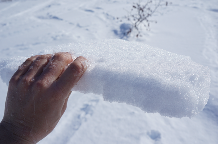
Sun crusts as of Friday, two days ago. These crusts exist on east through south and west facing slopes – and even a few northerly aspects were reported to have a thin crust. It will provide a slick bed surface for the new snow to pile up onto. Photo by Megan Guinn, 4.7.23.

Avalanche Problem 2
  • Deep Persistent Slabs
    Deep Persistent Slabs
  • Certain
    Very Likely
    Likely
    Possible
    Unlikely
    Likelihood
  • Historic (D4-5)
    Very Large (D3)
    Large (D2)
    Small (D1)
    Size
Deep Persistent Slabs
Deep Persistent Slab avalanches are the release of a thick cohesive layer of hard snow (a slab), when the bond breaks between the slab and an underlying persistent weak layer deep in the snowpack. The most common persistent weak layers involved in deep, persistent slabs are depth hoar or facets surrounding a deeply buried crust. Deep Persistent Slabs are typically hard to trigger, are very destructive and dangerous due to the large mass of snow involved, and can persist for months once developed. They are often triggered from areas where the snow is shallow and weak, and are particularly difficult to forecast for and manage.

Likelihood of Avalanches
Terms such as "unlikely", "likely", and "certain" are used to define the scale, with the chance of triggering or observing avalanches increasing as we move up the scale. For our purposes, "Unlikely" means that few avalanches could be triggered in avalanche terrain and natural avalanches are not expected. "Certain" means that humans will be able to trigger avalanches on many slopes, and natural avalanches are expected.

Size of Avalanches
Avalanche size is defined by the largest potential avalanche, or expected range of sizes related to the problem in question. Assigned size is a qualitative estimate based on the destructive classification system and requires specialists to estimate the harm avalanches may cause to hypothetical objects located in the avalanche track (AAA 2016, CAA 2014). Under this schema, "Small" avalanches are not large enough to bury humans and are relatively harmless unless they carry people over cliffs or through trees or rocks. Moving up the scale, avalanches become "Large" enough to bury, injure, or kill people. "Very Large" avalanches may bury or destroy vehicles or houses, and "Historic" avalanches are massive events capable of altering the landscape.

Signal Word Size (D scale) Simple Descriptor
Small 1 Unlikely to bury a person
Large 2 Can bury a person
Very Large 3 Can destroy a house
Historic 4 & 5 Can destroy part or all of a village
More info at Avalanche.org

We are still concerned about the low likelihood but high consequence deep slab problem. This is due to a layer of weak snow around 3-6′ deep in the snowpack that was buried in mid-March. After a rash of human triggered deep slab avalanches two weeks ago, the past week has seen signs that this weak layer is gaining some strength. That said, we don’t want to be too quick to dismiss it altogether (more details in these observations from Bertha Creek and Pete’s North).

Although new snow will add a little stress to this layer today, it is’t likely enough to overload it. Meaning it is still unlikely for a deep slab to release, but it isn’t wholly out of the question. Continuing to use a cautious mindset and safe travel protocols to minimize exposure is recommended.


Taylor Pass viewed from below the Sunburst weather station on Friday. Winter remains despite being April! Photo by Megan Guinn, 4.7.23.

Weather
Sun, April 9th, 2023

Yesterday:  Mostly cloudy skies were over the region with a few snow flurries. Between a trace to 2″ of snow was seen through the day. Ridgetop winds were northwesterly in the 5-10mph range with gusts in the teens. Temperatures climbed to the mid 20’sF during the afternoon and have dropped into the teens and single digits overnight.

Today:  A cold storm is moving in that will bring between 8-18″ of new snow. Highest amounts are expected in Portage Valley. Snowfall should begin in earnest early this afternoon. Ridgetop winds will remain northwesterly and blow 10-15mph with gusts in the 20’s. Temperatures look to stay cool, in the teens in most mountain locations (20’sF at sea level).

Tomorrow:  Cloudy skies and light snowfall is expected to linger through Monday. An additional 1-4″ is forecast. Ridgetop winds swing around easterly and look to be in the 10-15mph range with stronger gusts. Temperatures remain cold for April, in the teens to 20’sF.

PRECIPITATION 24-hour data (6am – 6am)

Temp Avg (F) Snow (in) Water (in) Snow Depth (in)
Center Ridge (1880′) 25 0 0 88
Summit Lake (1400′) 24 0 0 44
Alyeska Mid (1700′) 22 2 0.1 83
Bear Valley – Portage (132′) 28 3 0.23

RIDGETOP 24-hour data (6am – 6am)

Temp Avg (F) Wind Dir Wind Avg (mph) Wind Gust (mph)
Sunburst (3812′) 14 W 5 12
Seattle Ridge (2400′) 16 NW 4 11
Observations
Recent Observations for Turnagain Pass
Date Region Location
03/28/24 Turnagain Observation: Sunburst
03/27/24 Turnagain Observation: Tincan Trees
03/26/24 Turnagain Observation: Cornbiscuit
03/25/24 Turnagain Observation: Tincan
03/22/24 Turnagain Avalanche: Magnum Northwest Aspect
03/21/24 Turnagain Observation: Sunburst
03/21/24 Turnagain Observation: Tincan Proper North Aspect
03/20/24 Turnagain Avalanche: Seattle Creek Drainage
03/19/24 Turnagain Observation: Tincan CFR
03/18/24 Turnagain Avalanche: Tincan – Eddies – Seattle Ridge
Riding Areas

The riding areas page has moved. Please click here & update your bookmarks.


Subscribe to Turnagain Pass
Avalanche Forecast by Email

This is a general backcountry avalanche advisory issued for Turnagain Arm with Turnagain Pass as the core advisory area. This advisory does not apply to highways, railroads or operating ski areas.