Turnagain Pass Avalanche Forecast RSS

Archives
ARCHIVED FORECAST - All forecasts expire after 24 hours from the posting date/time.
Issued
Sat, April 8th, 2023 - 7:00AM
Expires
Sun, April 9th, 2023 - 7:00AM
Forecaster
John Sykes
Avalanche risk The Bottom Line

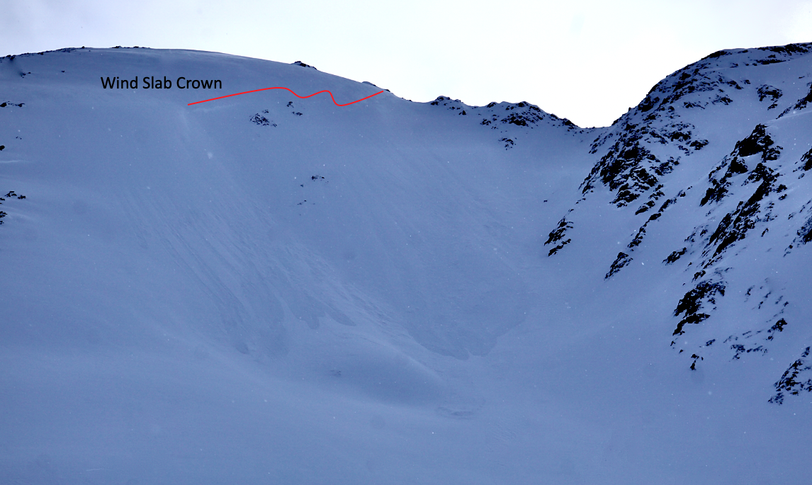
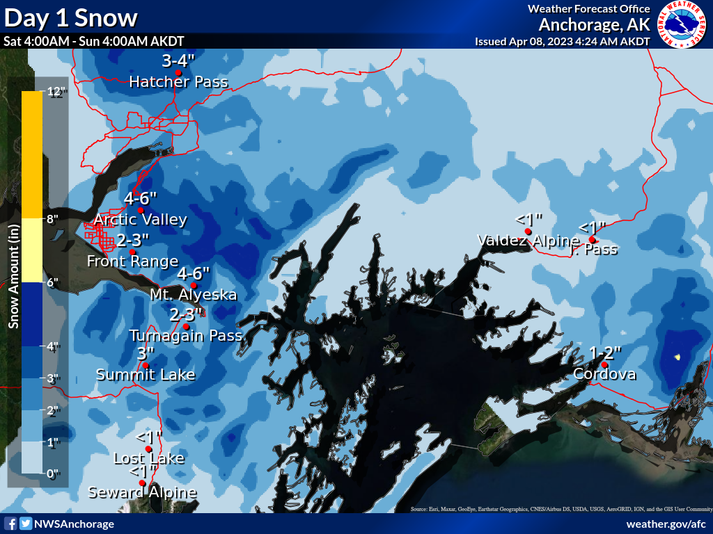
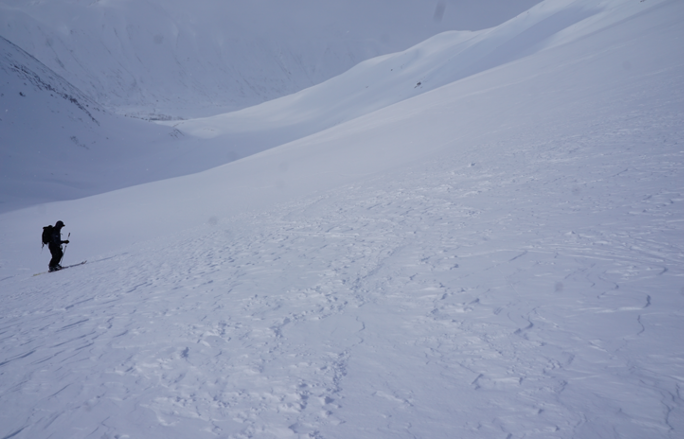
The avalanche danger remains MODERATE above 1000′. Up to 6″ of new snow today with winds expected to pick up in the afternoon will form fresh wind slabs up to 1′ deep. Human triggered and natural avalanches are possible with these fresh wind slabs. Deeper down in the snowpack a buried weak layer of facets 3-6′ deep is still concerning. Triggering an avalanche on this layer has become unlikely, but the consequences are high so we are keeping it on our radar awhile longer. Below 1000′ the avalanche danger is LOW.

Special Announcements

We’re looking for your input! We’ve made some changes to the forecast this year, and this is your chance for you to give us some feedback that will help us continue to improve our forecasts. These advisories are for you, and we’d love to hear how we can make them better. Click here to take a 5-10 min survey, we really appreciate your feedback!

Thanks to our sponsors!
Sat, April 8th, 2023
Alpine
Above 2,500'
Moderate (2)
Avalanche risk
Treeline
1,000'-2,500'
Moderate (2)
Avalanche risk
Below Treeline
Below 1,000'
Low (1)
Avalanche risk
Alpine
Above 2,500'
Avalanche risk
Moderate (2)
Treeline
1,000'-2,500'
Avalanche risk
Moderate (2)
Below Treeline
Below 1,000'
Avalanche risk
Low (1)
Danger Scale:
No Rating (0)
Low (1)
Moderate (2)
Considerable (3)
High (4)
Extreme (5)
Recent Avalanches

A few small wind slabs were observed yesterday afternoon near Taylor Pass. These were not big enough to bury a person, but their size will likely be increasing as we get more new snow over the next two days. Otherwise it has been over 10 days since the last human triggered avalanche on the deep persistent weak layer we are worried about.

Small natural wind slab that released on the N aspect of Magnum near Taylor Pass. Photo 4.8.23

Avalanche Problem 1
  • Deep Persistent Slabs
    Deep Persistent Slabs
  • Aspect/Elevation
  • Almost Certain
    Very Likely
    Likely
    Possible
    Unlikely
    Likelihood
  • Historic (D4-5)
    Very Large (D3)
    Large (D2)
    Small (D1)
    Size
Deep Persistent Slabs
Deep Persistent Slab avalanches are the release of a thick cohesive layer of hard snow (a slab), when the bond breaks between the slab and an underlying persistent weak layer deep in the snowpack. The most common persistent weak layers involved in deep, persistent slabs are depth hoar or facets surrounding a deeply buried crust. Deep Persistent Slabs are typically hard to trigger, are very destructive and dangerous due to the large mass of snow involved, and can persist for months once developed. They are often triggered from areas where the snow is shallow and weak, and are particularly difficult to forecast for and manage.

Aspect/Elevation of the Avalanche Problem
Specialists develop a graphic representation of the potential distribution of a particular avalanche problem across the topography. This aspect/elevation rose is used to indicate where the particular avalanche problem is thought to exist on all elevation aspects. Areas where the avalanche problem is thought to exist are colored grey, and it is less likely to be encountered in areas colored white.

Likelihood of Avalanches
Terms such as "unlikely", "likely", and "certain" are used to define the scale, with the chance of triggering or observing avalanches increasing as we move up the scale. For our purposes, "Unlikely" means that few avalanches could be triggered in avalanche terrain and natural avalanches are not expected. "Certain" means that humans will be able to trigger avalanches on many slopes, and natural avalanches are expected.

Size of Avalanches
Avalanche size is defined by the largest potential avalanche, or expected range of sizes related to the problem in question. Assigned size is a qualitative estimate based on the destructive classification system and requires specialists to estimate the harm avalanches may cause to hypothetical objects located in the avalanche track (AAA 2016, CAA 2014). Under this schema, "Small" avalanches are not large enough to bury humans and are relatively harmless unless they carry people over cliffs or through trees or rocks. Moving up the scale, avalanches become "Large" enough to bury, injure, or kill people. "Very Large" avalanches may bury or destroy vehicles or houses, and "Historic" avalanches are massive events capable of altering the landscape.

Signal Word Size (D scale) Simple Descriptor
Small 1 Unlikely to bury a person
Large 2 Can bury a person
Very Large 3 Can destroy a house
Historic 4 & 5 Can destroy part or all of a village
More info at Avalanche.org

Winter has dug it’s heals in and refuses to let go. Light snowfall is expected today with up to 6″ falling in Girdwood and coastal areas near Prince William Sound, and closer to 2-4″ in Turnagain Pass and Summit Lake. The unseasonably cold temperatures should keep the snowline down to sea level today. The relatively small amount of new snow accompanied by light winds in the 5-10 mph range during the day probably won’t be enough to dramatically increase the avalanche danger.

Our bigger concern is still the low likelihood but high consequence deep slab problem buried 3-6′ deep caused by a layer of facets buried in mid-March. Over the past week we have seen signs that this weak layer is gaining some strength, but we don’t want to be too quick to dismiss it altogether (more details in these observations from Bertha Creek and Pete’s North). If you decide to travel in avalanche terrain we recommend using safe travel protocols to minimize your groups exposure, like always spotting your partners and only exposing one member of your party to avalanche terrain at a time.

24 hour snowfall forecast starting Saturday morning. Graphic from NWS Anchorage 4.8.23

Avalanche Problem 2
  • Wind Slabs
    Wind Slabs
  • Aspect/Elevation
  • Almost Certain
    Very Likely
    Likely
    Possible
    Unlikely
    Likelihood
  • Historic (D4-5)
    Very Large (D3)
    Large (D2)
    Small (D1)
    Size
Wind Slabs
Wind Slab avalanches are the release of a cohesive layer of snow (a slab) formed by the wind. Wind typically transports snow from the upwind sides of terrain features and deposits snow on the downwind side. Wind slabs are often smooth and rounded and sometimes sound hollow, and can range from soft to hard. Wind slabs that form over a persistent weak layer (surface hoar, depth hoar, or near-surface facets) may be termed Persistent Slabs or may develop into Persistent Slabs.

Aspect/Elevation of the Avalanche Problem
Specialists develop a graphic representation of the potential distribution of a particular avalanche problem across the topography. This aspect/elevation rose is used to indicate where the particular avalanche problem is thought to exist on all elevation aspects. Areas where the avalanche problem is thought to exist are colored grey, and it is less likely to be encountered in areas colored white.

Likelihood of Avalanches
Terms such as "unlikely", "likely", and "certain" are used to define the scale, with the chance of triggering or observing avalanches increasing as we move up the scale. For our purposes, "Unlikely" means that few avalanches could be triggered in avalanche terrain and natural avalanches are not expected. "Certain" means that humans will be able to trigger avalanches on many slopes, and natural avalanches are expected.

Size of Avalanches
Avalanche size is defined by the largest potential avalanche, or expected range of sizes related to the problem in question. Assigned size is a qualitative estimate based on the destructive classification system and requires specialists to estimate the harm avalanches may cause to hypothetical objects located in the avalanche track (AAA 2016, CAA 2014). Under this schema, "Small" avalanches are not large enough to bury humans and are relatively harmless unless they carry people over cliffs or through trees or rocks. Moving up the scale, avalanches become "Large" enough to bury, injure, or kill people. "Very Large" avalanches may bury or destroy vehicles or houses, and "Historic" avalanches are massive events capable of altering the landscape.

Signal Word Size (D scale) Simple Descriptor
Small 1 Unlikely to bury a person
Large 2 Can bury a person
Very Large 3 Can destroy a house
Historic 4 & 5 Can destroy part or all of a village
More info at Avalanche.org

Winds are expected to pick up to 10-20 mph in the late afternoon or evening, which will quickly build wind slabs up to 1′ deep at upper elevations. Keep an eye out for active snow transport along ridgelines and shooting cracks in the surface snow to identify areas where wind slabs are building. The new snow will be falling onto a mix of old snow surfaces, ranging from icy crusts up to about 2000′ to dry new snow on high elevation northerly aspects. It is likely that the new snow will not bond very well to these old snow surfaces, which will become more of an issue on Sunday when we might get an additional 8-12″ of new snow!

Crusty snow surface with old tracks creating some roller balls on the surface. Photo 4.7.23

Wind textured snow surface at upper elevations. Photo 4.7.23

Weather
Sat, April 8th, 2023

Yesterday: Partly sunny skies for most of the day with clouds building later in the afternoon accompanied by some snow showers. No significant new snow accumulation. Winds averaged 5-15 mph with gusts up to 25 mph at upper elevations. Temperatures stayed cold at upper elevations, hoovering around 10-15 F throughout the day. At sea level temperatures rose into the low to mid 30s F during the late afternoon.

Today: Light snowfall is expected today with totals of 2-6″ of new snow throughout the day. Girdwood and areas near Prince William Sounds will likely see the most snowfall with up to 6″ expected today. Winds are expected be light at 5-10 mph during the day before picking up to around 10-20 mph in the late afternoon or evening. Temperatures are expected to remain below freezing down to sea level, with highs in the upper 20s to low 30s F. At upper elevations temperatures are expected to reach into the low 20s F.

Tomorrow: Snowfall is expected to intensify on Sunday with another 8-12″ expected in Girdwood and Turnagain Pass, and up to 24″ possible in favored areas along the coast near Portage and Whittier. Winds should remain in the 10-20 mph range with stronger gusts. Snowline is expected to remain at sea level, with temperatures reaching highs of around 15 F at upper elevations and in the low 20s F at lower elevations.

PRECIPITATION 24-hour data (6am – 6am)

Temp Avg (F) Snow (in) Water (in) Snow Depth (in)
Center Ridge (1880′) 25 1 0.2 89
Summit Lake (1400′) 24 1 0.1 44
Alyeska Mid (1700′) 24 0 0 81
Bear Valley – Portage (132′) 28 1 0.16

RIDGETOP 24-hour data (6am – 6am)

Temp Avg (F) Wind Dir Wind Avg (mph) Wind Gust (mph)
Sunburst (3812′) 15 ENE 9 28
Seattle Ridge (2400′) 19 ESE 4 14
Observations
Recent Observations for Turnagain Pass
Date Region Location
05/22/23 Turnagain Avalanche: Tincan
05/12/23 Turnagain Avalanche: Tincan, Sunburst, Magnum, Cornbiscuit
05/07/23 Turnagain Observation: Tincan – Bear Tracks
05/05/23 Turnagain Observation: Seattle Ridge
05/02/23 Turnagain Observation: Cornbiscuit
05/02/23 Turnagain Observation: Seward Hwy Turnagain Pass
04/30/23 Turnagain Observation: Magnum
04/29/23 Turnagain Observation: Tincan
04/28/23 Turnagain Avalanche: Taylor Pass/Pastoral
04/28/23 Turnagain Avalanche: Tincan
Riding Areas
Updated Thu, June 01st, 2023

Status of riding areas across the Chugach NF is managed by the Glacier and Seward Ranger Districts, not avalanche center staff. Riding area information is posted as a public service to our users and updated based on snow depth and snow density to prevent resource damage at trailhead locations. Riding area questions contact: mailroom_r10_chugach@fs.fed.us

Area Status Weather & Riding Conditions
Glacier District
Johnson Pass
Closed
Closed May 15.
Placer River
Closed
Closed May 15.
Skookum Drainage
Closed
Will close to motorized use on April 1, 2023 per the National Forest Plan.
Turnagain Pass
Closed
Will close on June 1.
Twentymile
Closed
Scheduled closure May 1.
Seward District
Carter Lake
Closed
Scheduled closure May 1.
Lost Lake Trail
Closed
Scheduled closure May 1.
Primrose Trail
Closed
Scheduled closure May 1.
Resurrection Pass Trail
Closed
Closed to motorized use for the 2022/23 winter season per Forest Plan. Open next season.
Snug Harbor
Closed
Extended opening until May 15.
South Fork Snow River Corridor
Closed
Scheduled closure May 1.
Summit Lake
Closed
Scheduled closure May 1.

Subscribe to Turnagain Pass
Avalanche Forecast by Email

This is a general backcountry avalanche advisory issued for Turnagain Arm with Turnagain Pass as the core advisory area. This advisory does not apply to highways, railroads or operating ski areas.