Turnagain Pass Avalanche Forecast RSS

Archives
ARCHIVED FORECAST - All forecasts expire after 24 hours from the posting date/time.
Issued
Sun, April 3rd, 2022 - 7:00AM
Expires
Mon, April 4th, 2022 - 7:00AM
Forecaster
Andrew Schauer
Avalanche risk The Bottom Line

The avalanche danger is CONSIDERABLE above 1000′. It is likely a person will trigger an avalanche failing below the snow that fell on Friday, which buried weak surfaces and will still be reactive today. There are also deeper weak layers lurking 3-6′ deep that have the potential to make very large avalanches. This dangerous combination of avalanche problems requires cautious route finding, which means limiting time spent traveling on and below steep terrain. The danger is MODERATE below 1000′, where the main concern will be wet snow avalanches as the snow surface heats during the day.


Special Announcements
  • South Fork of Eagle River Avalanche (3 Bowls):  Crews continue to work to remove the avalanche debris covering Hiland Road and the Municipality of Anchorage has a dashboard with this information. The Municipality of Anchorage is asking the public to stay away from the immediate slide area. It is important to give the workers a safe space to clear the road.
Thanks to our sponsors!
Sun, April 3rd, 2022
Alpine
Above 2,500'
Considerable (3)
Avalanche risk
Treeline
1,000'-2,500'
Considerable (3)
Avalanche risk
Below Treeline
Below 1,000'
Moderate (2)
Avalanche risk
Alpine
Above 2,500'
Avalanche risk
Considerable (3)
Treeline
1,000'-2,500'
Avalanche risk
Considerable (3)
Below Treeline
Below 1,000'
Avalanche risk
Moderate (2)
Danger Scale:
No Rating (0)
Low (1)
Moderate (2)
Considerable (3)
High (4)
Extreme (5)
Recent Avalanches

We saw very touchy conditions for the second day in a row yesterday. With poor visibility along the road corridor in the morning and afternoon, we have limited info on yesterday’s activity. Here is what we know happened:

  • Tincan: Yesterday was another good day of avalanche spectating on Tincan, with multiple natural avalanches during the day, and one remotely triggered avalanche in Common Bowl. Most of these were failing on south- to west-facing slopes. They were failing below Friday’s storm snow, which was sitting on a layer of surface hoar and near-surface facets on top of a crust. Crowns were 12-18″ deep, and the slabs were 100-150′ wide for the most part. Multiple avalanches released simultaneously in Hippie Bowl, indicating wide propagation at that weak interface. More information in observations here and here.
  • Seattle Ridge: We have limited information from the backside of Seattle Ridge, but we do know there was at least one avalanche similar in size to what we saw on Tincan.
  • Eddie’s: It looked like there was one fresh avalanche on the Eddie’s Headwall that either happened yesterday or in the middle of the storm on Friday.

Looking at all of the activity on the south face of Tincan from the Center Ridge parking lot. Red arrows are natural, purple arrow was triggered remotely from low-angle terrain connected to the slope that released. 04.02.2022


Avalanche Problem 1
  • Persistent Slabs
    Persistent Slabs
  • Almost Certain
    Very Likely
    Likely
    Possible
    Unlikely
    Likelihood
  • Historic (D4-5)
    Very Large (D3)
    Large (D2)
    Small (D1)
    Size
Persistent Slabs
Persistent Slab avalanches are the release of a cohesive layer of snow (a slab) in the middle to upper snowpack, when the bond to an underlying persistent weak layer breaks. Persistent layers include: surface hoar, depth hoar, near-surface facets, or faceted snow. Persistent weak layers can continue to produce avalanches for days, weeks or even months, making them especially dangerous and tricky. As additional snow and wind events build a thicker slab on top of the persistent weak layer, this avalanche problem may develop into a Deep Persistent Slab.

Likelihood of Avalanches
Terms such as "unlikely", "likely", and "certain" are used to define the scale, with the chance of triggering or observing avalanches increasing as we move up the scale. For our purposes, "Unlikely" means that few avalanches could be triggered in avalanche terrain and natural avalanches are not expected. "Certain" means that humans will be able to trigger avalanches on many slopes, and natural avalanches are expected.

Size of Avalanches
Avalanche size is defined by the largest potential avalanche, or expected range of sizes related to the problem in question. Assigned size is a qualitative estimate based on the destructive classification system and requires specialists to estimate the harm avalanches may cause to hypothetical objects located in the avalanche track (AAA 2016, CAA 2014). Under this schema, "Small" avalanches are not large enough to bury humans and are relatively harmless unless they carry people over cliffs or through trees or rocks. Moving up the scale, avalanches become "Large" enough to bury, injure, or kill people. "Very Large" avalanches may bury or destroy vehicles or houses, and "Historic" avalanches are massive events capable of altering the landscape.

Signal Word Size (D scale) Simple Descriptor
Small 1 Unlikely to bury a person
Large 2 Can bury a person
Very Large 3 Can destroy a house
Historic 4 & 5 Can destroy part or all of a village
More info at Avalanche.org

The snow that fell on Friday buried weak snow surfaces, and has been producing natural and human-triggered avalanches for the past two days. Yesterday we saw multiple natural avalanches in the Tincan area, and were triggering avalanches remotely from low-angle terrain connected to steeper slopes. The snowpack has shown that this latest round of storm snow is slow to heal, and it is likely a person will still be able to trigger avalanches 1-2′ deep today. The layer of concern is a thin layer of small buried surface hoar and near-surface facets that formed during clear weather on Wednesday. This layer appears to be most reactive on slopes that formed a crust ahead of the storm, but one group yesterday noted a clean shear in a test pit on a northerly slope that appeared to fail on a similar layer of surface hoar.

It is looking like we will see some periods of sun with mild temperatures today. As the snow surface heats up, expect to see increasing likelihood of natural and human-triggered activity. This was the case yesterday, and it is likely we will see similar activity today. So far these avalanches have not been huge, but we have seen multiple avalanches big enough to bury a person. There were multiple avalanches that were triggered remotely, or released sympathetically with other slopes, which tells us the weak interface has the potential to propagate wide distances. This might make it possible to see larger avalanches at this upper interface. Avalanches failing in the upper snowpack have the potential to step down to deeper weak layers, making for very large avalanches. More on this in problem 2 below.

With a reactive weak layer in the upper 2′ of the snowpack and warm temperatures and sunny skies contributing to deteriorating stability today, this is not the time to push it into steep terrain. Be cautious with your route finding today, avoiding traveling on or below large steep slopes.

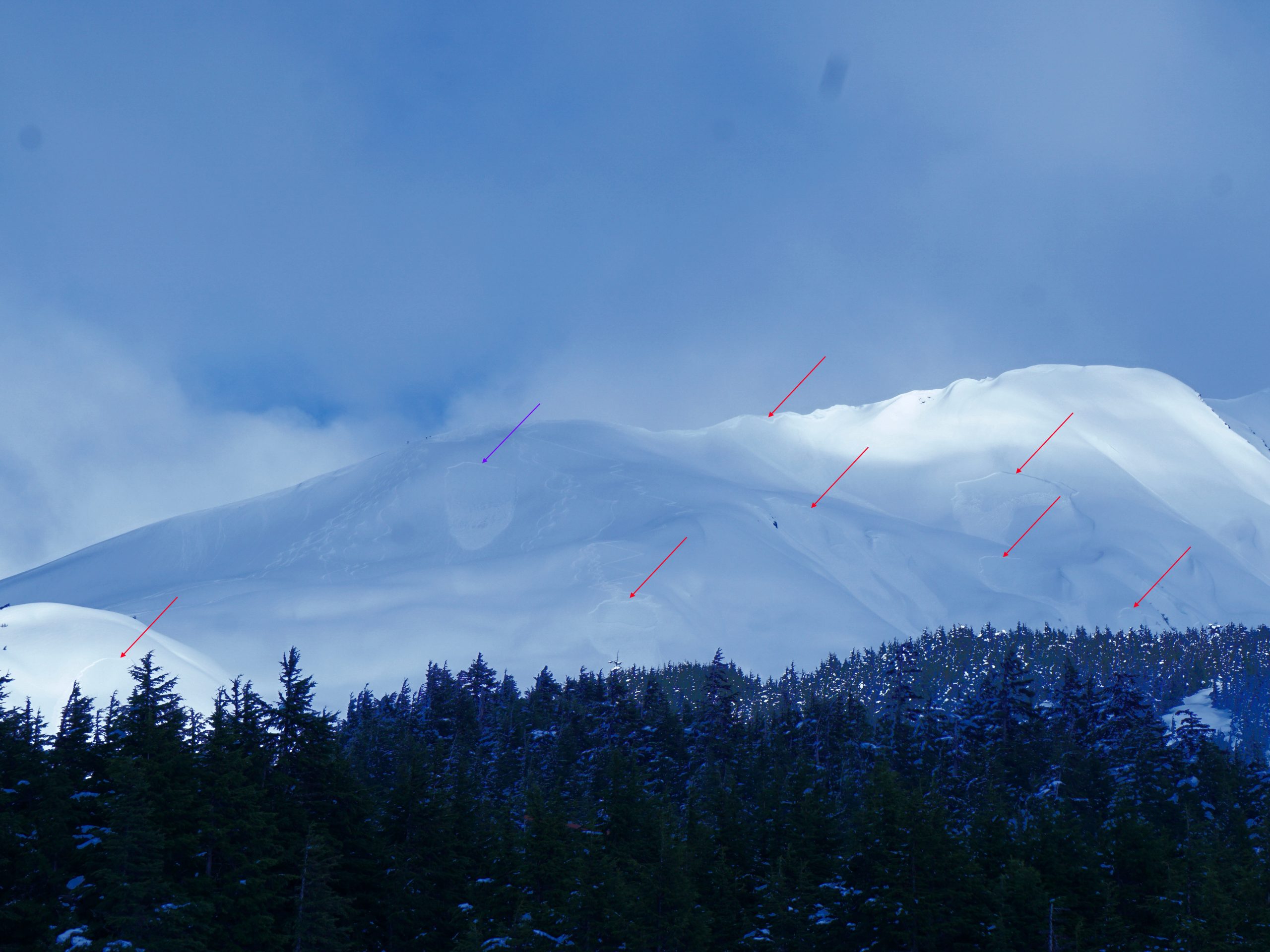
These slopes in Hippie Bowl all released naturally, at the same time. This happened shortly after the sun popped out, and it is likely that one of the pockets released and triggered the rest sympathetically. W-SW aspect, 2800-3400′ elevation. 04.02.2022

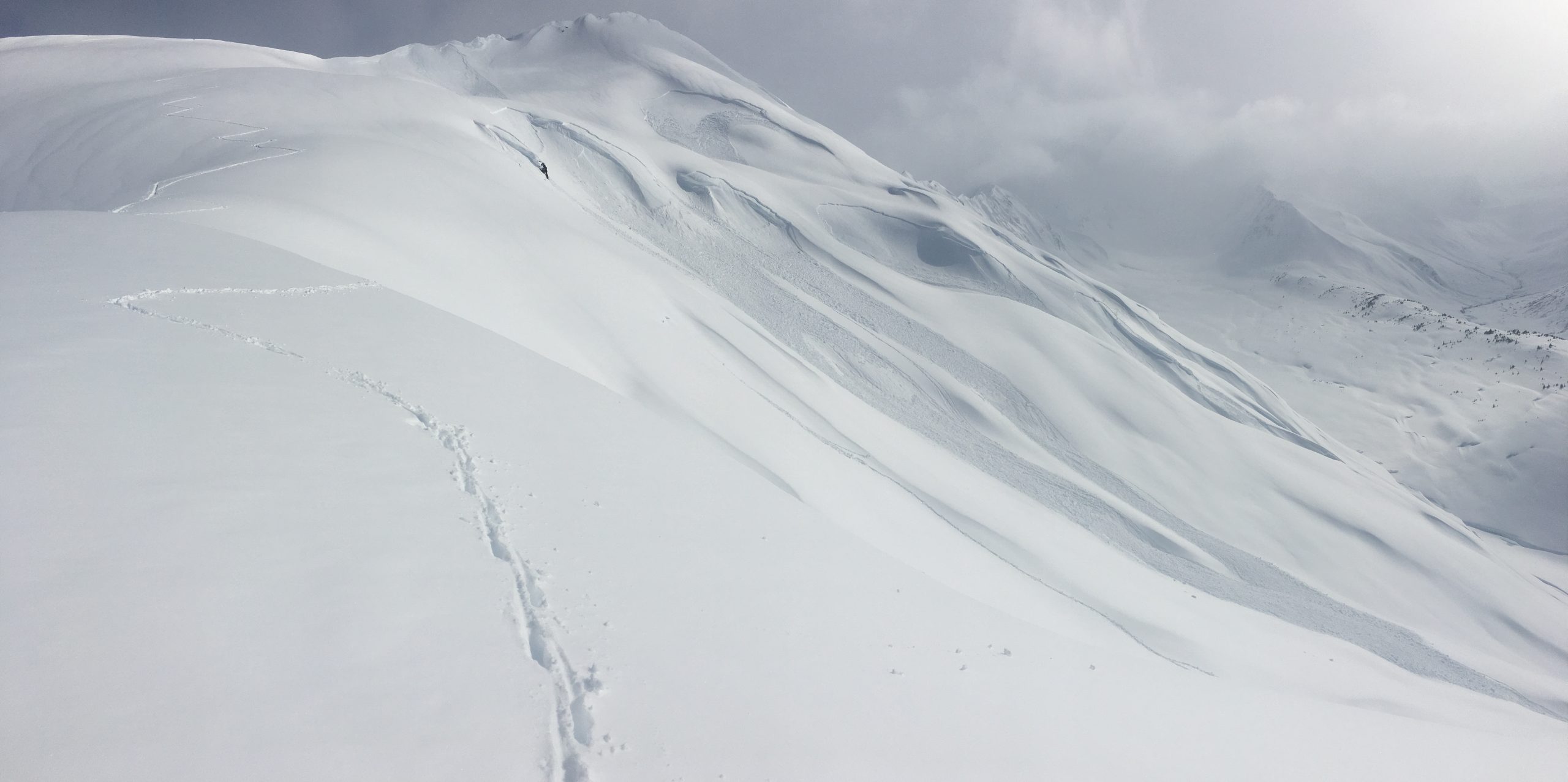
We dug a quick pit at the crown of one of the natural avalanches to get a good look at the bed surface. It was hard to see with a naked eye, but under the lens there were clearly small surface hoar grains, along with near-surface facets on top of a crust. 04.02.2022

Wet Loose Avalanches: If we do end up seeing extended periods of sunshine today, we can expect to see wet loose avalanches on steep slopes exposed to the sun. These avalanches might pull out more slabs similar to what we saw on Tincan yesterday. Be on the lookout for warning signs of deteriorating stability on solar aspects, like rollerballs and pinwheels rolling down the slope as the snow surface heats up.

Cornices: These will also become more sensitive as they heat up today. A chunk of cornice falling on an avalanche-prone slope is a great way to trigger an avalanche. As always, limit time spent traveling under cornices, and be sure to give them plenty of space as you are traveling along ridgelines.

Glides:  We continue to see glide cracks moving throughout the area. Multiple glide avalanches have released over the past week, and the timing is impossible to predict. These avalanches are very large and destructive, so avoid spending time below these monsters.

Avalanche Problem 2
  • Deep Persistent Slabs
    Deep Persistent Slabs
  • Almost Certain
    Very Likely
    Likely
    Possible
    Unlikely
    Likelihood
  • Historic (D4-5)
    Very Large (D3)
    Large (D2)
    Small (D1)
    Size
Deep Persistent Slabs
Deep Persistent Slab avalanches are the release of a thick cohesive layer of hard snow (a slab), when the bond breaks between the slab and an underlying persistent weak layer deep in the snowpack. The most common persistent weak layers involved in deep, persistent slabs are depth hoar or facets surrounding a deeply buried crust. Deep Persistent Slabs are typically hard to trigger, are very destructive and dangerous due to the large mass of snow involved, and can persist for months once developed. They are often triggered from areas where the snow is shallow and weak, and are particularly difficult to forecast for and manage.

Likelihood of Avalanches
Terms such as "unlikely", "likely", and "certain" are used to define the scale, with the chance of triggering or observing avalanches increasing as we move up the scale. For our purposes, "Unlikely" means that few avalanches could be triggered in avalanche terrain and natural avalanches are not expected. "Certain" means that humans will be able to trigger avalanches on many slopes, and natural avalanches are expected.

Size of Avalanches
Avalanche size is defined by the largest potential avalanche, or expected range of sizes related to the problem in question. Assigned size is a qualitative estimate based on the destructive classification system and requires specialists to estimate the harm avalanches may cause to hypothetical objects located in the avalanche track (AAA 2016, CAA 2014). Under this schema, "Small" avalanches are not large enough to bury humans and are relatively harmless unless they carry people over cliffs or through trees or rocks. Moving up the scale, avalanches become "Large" enough to bury, injure, or kill people. "Very Large" avalanches may bury or destroy vehicles or houses, and "Historic" avalanches are massive events capable of altering the landscape.

Signal Word Size (D scale) Simple Descriptor
Small 1 Unlikely to bury a person
Large 2 Can bury a person
Very Large 3 Can destroy a house
Historic 4 & 5 Can destroy part or all of a village
More info at Avalanche.org

We are still concerned with the deeper layers of surface hoar buried last month. These deep persistent slab problems have some nasty characteristics that make them very dangerous and very hard to manage:

  • They seldom give feedback indicating unstable conditions prior to avalanching. This means our typical red flags (cracking, collapsing, new avalanches, unstable test results) will not always pop up before a person triggers a massive avalanche.
  • They are stubborn to trigger, which can allow for multiple tracks on a slope before a person triggers an avalanche. It can also make it possible that a person gets way out into the middle of a slope before triggering a large avalanche.
  • The slabs are thick, and they can propagate very long distances, making for very large and unsurvivable avalanches.

The avalanches failing closer to the surface (discussed in problem 1 above) have the potential to trigger a much larger avalanche down on these deeper weak layers. This is just one more reason to dial terrain back a notch today, limiting time spent traveling on or below steep avalanche terrain.

Click Here if the video below doesn’t load in your browser.

Weather
Sun, April 3rd, 2022

Yesterday: Skies were partly to mostly cloudy, with some extended periods of sun in the middle of the day. High temperatures were in the upper 20’s F at higher elevations and up to the low 40’s F at lower elevations. Winds were easterly to northerly, at 10-20 mph in the morning and dropping to 5-10 mph later in the day. A trace of snow fell in the morning.

Today: Today is looking similar to yesterday, with partly cloudy skies and high temperatures in the mid 20’s to upper 30’s F. Winds will be light and variable, with increasing clouds later in the day and chances of precipitation picking up this evening. Overnight lows will be in the upper teens to mid 20’s F.

Tomorrow: Chances for precipitation pick up overnight, with light snowfall bringing 1-3″ by the end of the day tomorrow. Snow level should stay down around 200-300′. Winds will be 5-15 mph out of the southeast, with high temperatures in the mid 20’s to 40 F under mostly cloudy to overcast skies.

PRECIPITATION 24-hour data (6am – 6am)

Temp Avg (F) Snow (in) Water (in) Snow Depth (in)
Center Ridge (1880′) N/A* N/A* N/A* N/A*
Summit Lake (1400′) N/A* N/A* N/A* N/A*
Alyeska Mid (1700′) 35 tr tr N/A

*Snotel stations have been down since Friday afternoon.

RIDGETOP 24-hour data (6am – 6am)

Temp Avg (F) Wind Dir Wind Avg (mph) Wind Gust (mph)
Sunburst (3812′) 21 NE 9 32
Seattle Ridge (2400′) 25 N/A* N/A* N/A*

*Seattle Ridge anemometer is rimed over and not reporting.

Observations
Recent Observations for Turnagain Pass
Date Region Location
05/22/23 Turnagain Avalanche: Tincan
05/12/23 Turnagain Avalanche: Tincan, Sunburst, Magnum, Cornbiscuit
05/07/23 Turnagain Observation: Tincan – Bear Tracks
05/05/23 Turnagain Observation: Seattle Ridge
05/02/23 Turnagain Observation: Cornbiscuit
05/02/23 Turnagain Observation: Seward Hwy Turnagain Pass
04/30/23 Turnagain Observation: Magnum
04/29/23 Turnagain Observation: Tincan
04/28/23 Turnagain Avalanche: Taylor Pass/Pastoral
04/28/23 Turnagain Avalanche: Tincan
Riding Areas
Updated Thu, June 01st, 2023

Status of riding areas across the Chugach NF is managed by the Glacier and Seward Ranger Districts, not avalanche center staff. Riding area information is posted as a public service to our users and updated based on snow depth and snow density to prevent resource damage at trailhead locations. Riding area questions contact: mailroom_r10_chugach@fs.fed.us

Area Status Weather & Riding Conditions
Glacier District
Johnson Pass
Closed
Closed May 15.
Placer River
Closed
Closed May 15.
Skookum Drainage
Closed
Will close to motorized use on April 1, 2023 per the National Forest Plan.
Turnagain Pass
Closed
Will close on June 1.
Twentymile
Closed
Scheduled closure May 1.
Seward District
Carter Lake
Closed
Scheduled closure May 1.
Lost Lake Trail
Closed
Scheduled closure May 1.
Primrose Trail
Closed
Scheduled closure May 1.
Resurrection Pass Trail
Closed
Closed to motorized use for the 2022/23 winter season per Forest Plan. Open next season.
Snug Harbor
Closed
Extended opening until May 15.
South Fork Snow River Corridor
Closed
Scheduled closure May 1.
Summit Lake
Closed
Scheduled closure May 1.

Subscribe to Turnagain Pass
Avalanche Forecast by Email

This is a general backcountry avalanche advisory issued for Turnagain Arm with Turnagain Pass as the core advisory area. This advisory does not apply to highways, railroads or operating ski areas.