Turnagain Pass RSS

Archives
ARCHIVED - Forecasts expire after 24 hours.
Issued
Sat, April 2nd, 2022 - 7:00AM
Expires
Sun, April 3rd, 2022 - 7:00AM
Forecaster
John Sykes
Avalanche risk The Bottom Line

The avalanche danger is CONSIDERABLE  above 1000′. Wind slabs and storm slabs 1-3′ deep are very likely to be triggered by a person and natural avalanches are possible. The new snow over the past 24 hours is not bonding well to the old snow surface, with widespread avalanche activity on small terrain features near treeline yesterday. Deeper avalanches on weak layers buried 4-6′ deep are also possible. Conservative decision-making and cautious route finding is recommended today. Below 1000′ the avalanche danger is MODERATE. Wet loose avalanches are likely if the new snow is still moist today.

SUMMIT LAKE/LOST LAKE/SNUG HARBOR: Snowfall and strong winds over the past 24 hours are increasing the avalanche danger. Potential for avalanches on deeper weak layers is higher with this new load, especially in areas with a thinner overall snowpack like Summit Lake.

Special Announcements
  • South Fork of Eagle River Avalanche (3 Bowls):  Removal of avalanche debris covering Hiland Road is continuing and the Municipality of Anchorage has a dashboard with this information. The Municipality of Anchorage is also asking the public to stay away from the immediate slide area. It is important to give the workers a safe space to clear the road.
Sat, April 2nd, 2022
Alpine
Above 2,500'
3 - Considerable
Avalanche risk
Treeline
1,000'-2,500'
3 - Considerable
Avalanche risk
Below Treeline
Below 1,000'
2 - Moderate
Avalanche risk
0 - No Rating
1 - Low
2 - Moderate
3 - Considerable
4 - High
5 - Extreme
Avalanche risk Avalanche risk Avalanche risk Avalanche risk Avalanche risk
Travel Advice Generally safe avalanche conditions. Watch for unstable snow on isolated terrain features. Heightened avalanche conditions on specific terrain features. Evaluate snow and terrain carefully; identify features of concern. Dangerous avalanche conditions. Careful snowpack evaluation, cautious route-finding, and conservative decision-making essential. Very dangerous avalanche conditions. Travel in avalanche terrain not recommended. Extraordinarily dangerous avalanche conditions. Avoid all avalanche terrain.
Likelihood of Avalanches Natural and human-triggered avalanches unlikely. Natural avalanches unlikely; human-triggered avalanches possible. Natural avalanches possible; human-triggered avalanches likely. Natural avalanches likely; human-triggered avalanches very likely. Natural and human-triggered avalanches certain.
Avalanche Size and Distribution Small avalanches in isolated areas or extreme terrain. Small avalanches in specific areas; or large avalanches in isolated areas. Small avalanches in many areas; or large avalanches in specific areas; or very large avalanches in isolated areas. Large avalanches in many areas; or very large avalanches in specific areas. Very large avalanches in many areas.
Recent Avalanches

Tincan Trees – Wind slab and storm slab avalanches were very reactive on Tincan yesterday, with remote triggering and wide propagation on all terrain with steep enough slope angles. Several avalanches were triggered by different parties and they ranged from 12-24″ deep and 50-150′ wide. Most of the avalanches we saw were remote triggered by skiers on lower angle terrain adjacent to steeper roll overs. Visibility was very poor so we don’t know how reactive the new snow was above treeline, but it is a safe guess that the potential for wide propagation exists in alpine areas as well.

Wind slab with very wide propagation on a small steep terrain feature near treeline on Tincan. Photo from Anonymous 4.1.22

Avalanche Problem 1
  • Storm Slabs
    Storm Slabs
  • Certain
    Very Likely
    Likely
    Possible
    Unlikely
    Likelihood
  • Historic (D4-5)
    Very Large (D3)
    Large (D2)
    Small (D1)
    Size
Storm Slabs
Storm Slab avalanches are the release of a cohesive layer (a slab) of new snow that breaks within new snow or on the old snow surface. Storm-slabs typically last between a few hours and few days (following snowfall). Storm-slabs that form over a persistent weak layer (surface hoar, depth hoar, or near-surface facets) may be termed Persistent Slabs or may develop into Persistent Slabs.

Likelihood of Avalanches
Terms such as "unlikely", "likely", and "certain" are used to define the scale, with the chance of triggering or observing avalanches increasing as we move up the scale. For our purposes, "Unlikely" means that few avalanches could be triggered in avalanche terrain and natural avalanches are not expected. "Certain" means that humans will be able to trigger avalanches on many slopes, and natural avalanches are expected.

Size of Avalanches
Avalanche size is defined by the largest potential avalanche, or expected range of sizes related to the problem in question. Assigned size is a qualitative estimate based on the destructive classification system and requires specialists to estimate the harm avalanches may cause to hypothetical objects located in the avalanche track (AAA 2016, CAA 2014). Under this schema, "Small" avalanches are not large enough to bury humans and are relatively harmless unless they carry people over cliffs or through trees or rocks. Moving up the scale, avalanches become "Large" enough to bury, injure, or kill people. "Very Large" avalanches may bury or destroy vehicles or houses, and "Historic" avalanches are massive events capable of altering the landscape.

Signal Word Size (D scale) Simple Descriptor
Small 1 Unlikely to bury a person
Large 2 Can bury a person
Very Large 3 Can destroy a house
Historic 4 & 5 Can destroy part or all of a village
More info at Avalanche.org

As of the publication of this forecast the SNOTEL station at Center Ridge in Turnagain Pass stopped transmitting data at 5 pm last night, so we are blind to the amount of new snow that fell overnight. The weather forecast was expecting 6-12″ of additional snowfall overnight. In the field yesterday we saw 6-10″ of  new snow had already fallen by 4 pm yesterday, which means anywhere from 12-22″ of new snow could have fallen in Turnagain Pass over the past 24 hours. Girdwood appears to have received less snowfall, with 3-8″ total over the past 24 hours. Portage and Placer have received about 12″ so far, with another 6″ expected in those coastal areas throughout the day today. Without knowing whether the Turnagain Pass overnight snowfall forecast verified and the fact that we saw very touchy wind slabs and storm slabs on Tincan yesterday I am taking a conservative mindset to the forecast this morning.

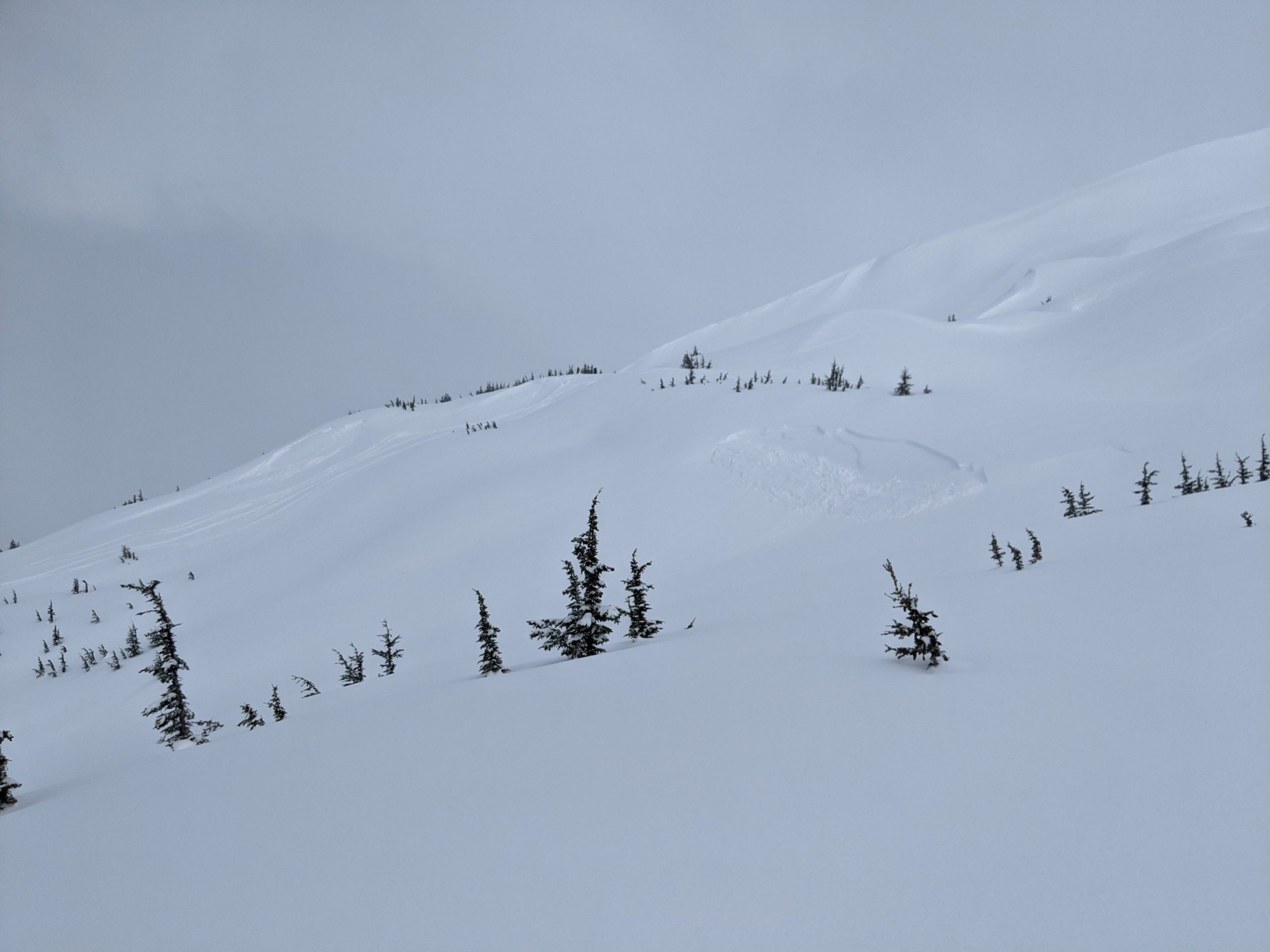
The new snow fell on top of a layer of surface hoar and facets which formed above a breakable melt freeze crust that exists on all aspects up to at least 3000′. These weak layers above a crust were causing widespread avalanches with wide propagation and easy remote triggering at treeline on Tincan yesterday (see ob here). Below 2000′ the new snow was more moist and we did not see the same kind of propagation and remote triggering, but the new snow was still not bonding well to the old surface and wet loose avalanches were easy to trigger. In addition, strong winds with averages of 20-40 mph for the past 24 hours and gusts of 40-60 mph are redistributing that snow into wind slabs in the alpine and treeline elevation bands.

The primary avalanche problems today are wind slabs and storm slabs that have formed over the past 24 hours and are expected to be up to 3′ deep in wind loaded areas. Human triggered avalanches are very likely and natural avalanches are likely. Winds are expected to decrease today and minimal new snow is expected to fall today, so the potential for natural avalanches will likely decrease throughout the day. We recommend conservative decision-making and terrain selection today as you start to evaluate how the new snow is bonding to the old snow surface. Using small test rolls to check for shooting cracks and small avalanches is a good idea before venturing into any bigger terrain. We also have deeper weak layers in the snowpack that have the potential to produce very large avalanches (see problem 2 for more details).

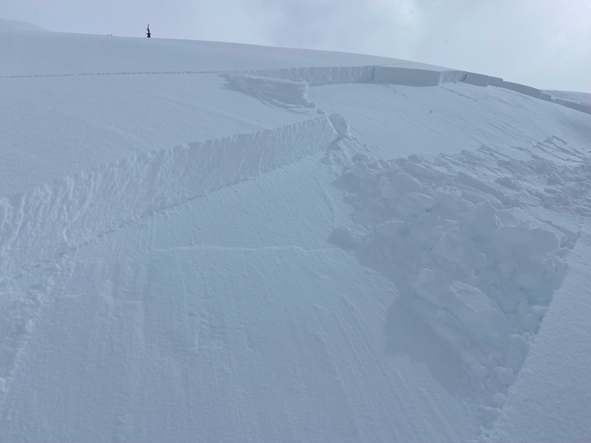
Two remote triggered avalanches at treeline on Tincan which released at the interface of the new snow and old snow. Photo 4.1.22

Glide Avalanches: Several reports of glide avalanches releasing this week mean that we need to be extra cautious around glide cracks. They have been growing over the past couple weeks across the forecast area and seem primed to start releasing based on the recent activity. These can create very large and destructive avalanches, and the best way to avoid them is just to stay out from underneath them.

Cornices: We have also seen several large natural cornice falls this week that have triggered avalanches on the slopes below. With the recent strong winds and moist snow cornices have been growing again and could be extra sensitive to breaking under the weight of a person. Give them a wide berth along ridgelines and be aware of actively building cornices if you are travelling underneath them.

Avalanche Problem 2
  • Deep Persistent Slabs
    Deep Persistent Slabs
  • Certain
    Very Likely
    Likely
    Possible
    Unlikely
    Likelihood
  • Historic (D4-5)
    Very Large (D3)
    Large (D2)
    Small (D1)
    Size
Deep Persistent Slabs
Deep Persistent Slab avalanches are the release of a thick cohesive layer of hard snow (a slab), when the bond breaks between the slab and an underlying persistent weak layer deep in the snowpack. The most common persistent weak layers involved in deep, persistent slabs are depth hoar or facets surrounding a deeply buried crust. Deep Persistent Slabs are typically hard to trigger, are very destructive and dangerous due to the large mass of snow involved, and can persist for months once developed. They are often triggered from areas where the snow is shallow and weak, and are particularly difficult to forecast for and manage.

Likelihood of Avalanches
Terms such as "unlikely", "likely", and "certain" are used to define the scale, with the chance of triggering or observing avalanches increasing as we move up the scale. For our purposes, "Unlikely" means that few avalanches could be triggered in avalanche terrain and natural avalanches are not expected. "Certain" means that humans will be able to trigger avalanches on many slopes, and natural avalanches are expected.

Size of Avalanches
Avalanche size is defined by the largest potential avalanche, or expected range of sizes related to the problem in question. Assigned size is a qualitative estimate based on the destructive classification system and requires specialists to estimate the harm avalanches may cause to hypothetical objects located in the avalanche track (AAA 2016, CAA 2014). Under this schema, "Small" avalanches are not large enough to bury humans and are relatively harmless unless they carry people over cliffs or through trees or rocks. Moving up the scale, avalanches become "Large" enough to bury, injure, or kill people. "Very Large" avalanches may bury or destroy vehicles or houses, and "Historic" avalanches are massive events capable of altering the landscape.

Signal Word Size (D scale) Simple Descriptor
Small 1 Unlikely to bury a person
Large 2 Can bury a person
Very Large 3 Can destroy a house
Historic 4 & 5 Can destroy part or all of a village
More info at Avalanche.org

With a new load added to the snowpack over the past 24 hours there is a higher chance of triggering a deeper avalanche on a layer of buried surface hoar or near surface facets that are now buried 4-6′ deep. Deep persistent slabs are very hard to evaluate with instability tests and unfortunately require patience to let them become unreactive before safely venturing back into bigger terrain. The easy way to avoid them is to select lower angle terrain, generally less than 30 degree slope angle. If you do venture into steeper terrain remember to follow safe travel protocols by only having 1 person in avalanche terrain at a time, stopping in safe areas, and always spotting your partners.

Weather
Sat, April 2nd, 2022

Yesterday: Snow throughout the day, heavy at times, with about 6″ of moist new snow at road elevation and 10″ at 2000′. Snowline up to 1000′ in the morning, dropping to 200′ in the afternoon. Winds were transporting snow down into the treeline elevation band, with ridgetop averages in the 25-40 mph range for most of the day and gusts up to 70 mph. Temperatures were in the mid 30s at road level and 20s at our high point at 2300′.

Today: Snowfall is expected to taper off this morning in Turnagain Pass and Girdwood, with up to 2″ of additional accumulation. Portage and Placer are expected to get another 6″ of new snow today with most of that coming in the morning. Snow line will rise to 400′ as the temperatures increase midday, but most of the precipitation should be over by then. Wind speeds are also expected to drop off today with averages in the 20-30 mph range in the morning decreasing to 10-20 mph in the evening.

Tomorrow: Unsettled weather is expected through the weekend with possibility of snow showers and clouds moving through the area. No real snow accumulation is expected. Winds should remain light to moderate on Sunday and Monday, with potential for less cloud cover on Monday.

PRECIPITATION 24-hour data (6am – 6am)

Temp Avg (F) Snow (in) Water (in) Snow Depth (in)
Center Ridge (1880′) 34* 6* 0.5* 120*
Summit Lake (1400′) 35* 1* 0.1* 40*
Alyeska Mid (1700′) 32 5 0.4 NA

* SNOTEL stations at Center Ridge and Summit Lake stopped transmitting data at 5 pm and 4 pm on 4.1.22, respectively.

RIDGETOP 24-hour data (6am – 6am)

Temp Avg (F) Wind Dir Wind Avg (mph) Wind Gust (mph)
Sunburst (3812′) 21 ENE 33 70
Seattle Ridge (2400′) 24 SE 15 41
Observations
Recent Observations for Turnagain Pass
Date Region Location
04/23/24 Turnagain Observation: Turnagain Sunny Side
04/21/24 Turnagain Observation: Bertha Creek
04/20/24 Turnagain Avalanche: Spokane Creek
04/16/24 Turnagain Observation: Cornbiscuit
04/15/24 Turnagain Observation: Taylor Pass
04/15/24 Turnagain Observation: Seward Highway – Tern Lake to Portage
04/14/24 Turnagain Observation: Sunburst
04/14/24 Turnagain Observation: Turnagain Pass Snomo
04/13/24 Turnagain Observation: Spokane Creek
04/11/24 Turnagain Observation: Tincan
Riding Areas

The riding areas page has moved. Please click here & update your bookmarks.


Subscribe to Turnagain Pass
Avalanche Forecast by Email

This is a general backcountry avalanche advisory issued for Turnagain Arm with Turnagain Pass as the core advisory area. This advisory does not apply to highways, railroads or operating ski areas.