Turnagain Pass RSS

Archives
ARCHIVED - Forecasts expire after 24 hours.
Issued
Thu, March 30th, 2023 - 7:00AM
Expires
Fri, March 31st, 2023 - 7:00AM
Forecaster
John Sykes
Avalanche risk The Bottom Line

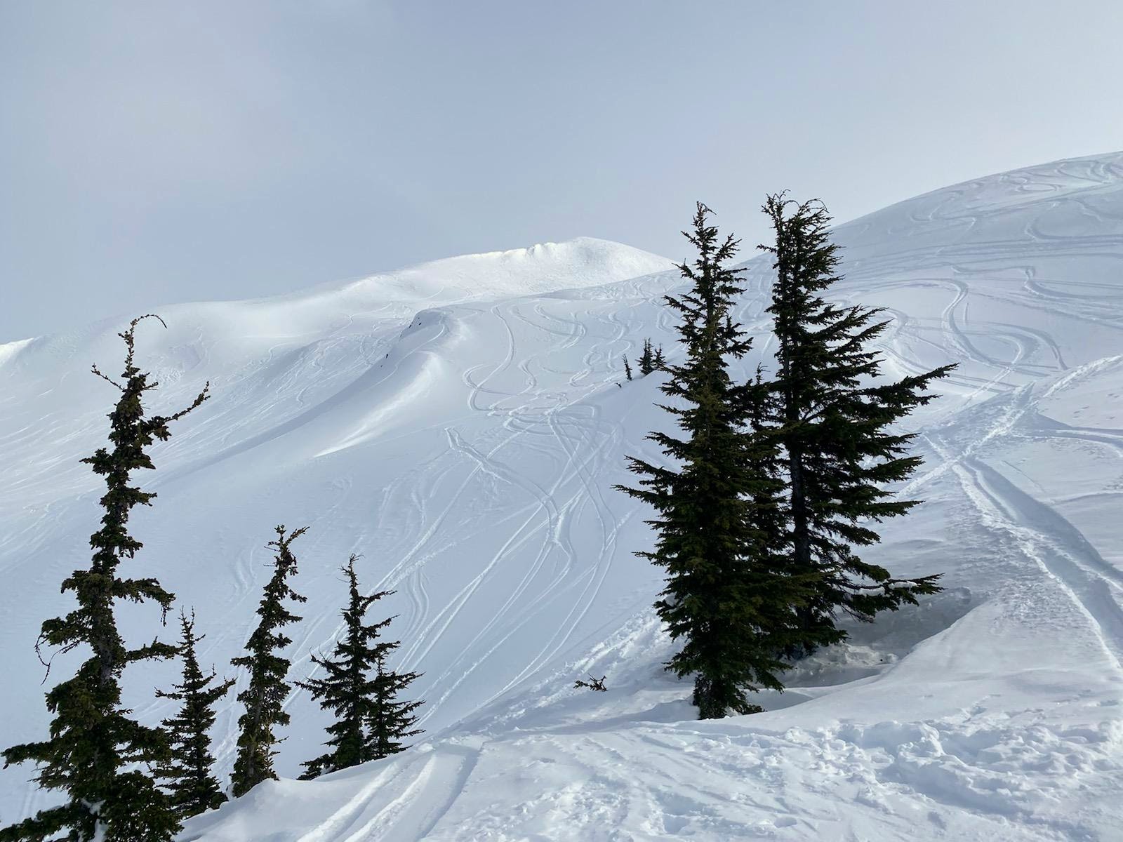
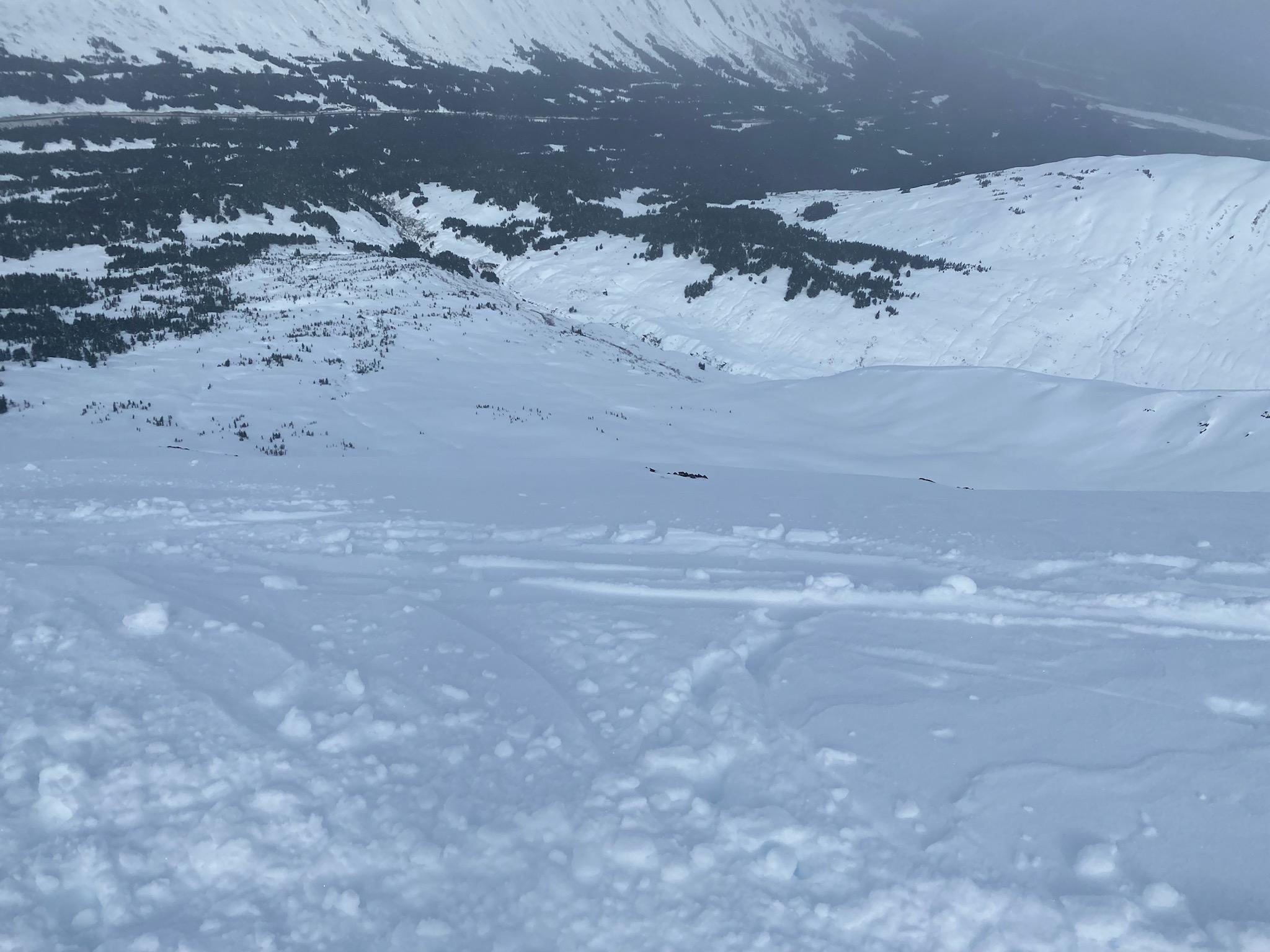
The avalanche danger remains CONSIDERABLE above 1000′ today. Human triggered avalanches 4-6′ deep are still possible and these very large avalanches can be triggered remotely from low angle terrain to the sides, below, or above steeper slopes. The potential for very large human triggered avalanches is driving us to keep the avalanche danger elevated even though the weather has been relatively quiet the last few days. Overnight a few inches of new snow and moderate winds built fresh wind slabs 6-12″ deep at upper elevations that are likely for human triggering today. We recommend continuing to adopt a conservative mindset by avoiding steep slopes and runout zones of larger avalanche paths.

The avalanche danger is MODERATE below 1000′ where human triggered avalanches are less likely.

Special Announcements

Support the avalanche forecast with Pick.Click.Give! 
Our Friends group funds 50% of our operating budget, forecaster salaries, and safety equipment to ensure professional, daily avalanche advisories all winter for the Chugach National Forest. The deadline is March 31, so follow these instructions today to support your daily avalanche forecast with your PFD. We thank you!

Thu, March 30th, 2023
Alpine
Above 2,500'
3 - Considerable
Avalanche risk
Treeline
1,000'-2,500'
3 - Considerable
Avalanche risk
Below Treeline
Below 1,000'
2 - Moderate
Avalanche risk
0 - No Rating
1 - Low
2 - Moderate
3 - Considerable
4 - High
5 - Extreme
Avalanche risk Avalanche risk Avalanche risk Avalanche risk Avalanche risk
Travel Advice Generally safe avalanche conditions. Watch for unstable snow on isolated terrain features. Heightened avalanche conditions on specific terrain features. Evaluate snow and terrain carefully; identify features of concern. Dangerous avalanche conditions. Careful snowpack evaluation, cautious route-finding, and conservative decision-making essential. Very dangerous avalanche conditions. Travel in avalanche terrain not recommended. Extraordinarily dangerous avalanche conditions. Avoid all avalanche terrain.
Likelihood of Avalanches Natural and human-triggered avalanches unlikely. Natural avalanches unlikely; human-triggered avalanches possible. Natural avalanches possible; human-triggered avalanches likely. Natural avalanches likely; human-triggered avalanches very likely. Natural and human-triggered avalanches certain.
Avalanche Size and Distribution Small avalanches in isolated areas or extreme terrain. Small avalanches in specific areas; or large avalanches in isolated areas. Small avalanches in many areas; or large avalanches in specific areas; or very large avalanches in isolated areas. Large avalanches in many areas; or very large avalanches in specific areas. Very large avalanches in many areas.
Recent Avalanches

We did not hear of any new avalanches yesterday, which is a relief after several days of very large human triggered avalanches. Check out observations from the last week from Magnum, Seattle Ridge, Sunburst, Palmer Creek (Hope), and Winner Creek to get a sense of the recent activity.

Avalanche Problem 1
  • Deep Persistent Slabs
    Deep Persistent Slabs
  • Aspect/Elevation
  • Certain
    Very Likely
    Likely
    Possible
    Unlikely
    Likelihood
  • Historic (D4-5)
    Very Large (D3)
    Large (D2)
    Small (D1)
    Size
Deep Persistent Slabs
Deep Persistent Slab avalanches are the release of a thick cohesive layer of hard snow (a slab), when the bond breaks between the slab and an underlying persistent weak layer deep in the snowpack. The most common persistent weak layers involved in deep, persistent slabs are depth hoar or facets surrounding a deeply buried crust. Deep Persistent Slabs are typically hard to trigger, are very destructive and dangerous due to the large mass of snow involved, and can persist for months once developed. They are often triggered from areas where the snow is shallow and weak, and are particularly difficult to forecast for and manage.

Aspect/Elevation of the Avalanche Problem
Specialists develop a graphic representation of the potential distribution of a particular avalanche problem across the topography. This aspect/elevation rose is used to indicate where the particular avalanche problem is thought to exist on all elevation aspects. Areas where the avalanche problem is thought to exist are colored grey, and it is less likely to be encountered in areas colored white.

Likelihood of Avalanches
Terms such as "unlikely", "likely", and "certain" are used to define the scale, with the chance of triggering or observing avalanches increasing as we move up the scale. For our purposes, "Unlikely" means that few avalanches could be triggered in avalanche terrain and natural avalanches are not expected. "Certain" means that humans will be able to trigger avalanches on many slopes, and natural avalanches are expected.

Size of Avalanches
Avalanche size is defined by the largest potential avalanche, or expected range of sizes related to the problem in question. Assigned size is a qualitative estimate based on the destructive classification system and requires specialists to estimate the harm avalanches may cause to hypothetical objects located in the avalanche track (AAA 2016, CAA 2014). Under this schema, "Small" avalanches are not large enough to bury humans and are relatively harmless unless they carry people over cliffs or through trees or rocks. Moving up the scale, avalanches become "Large" enough to bury, injure, or kill people. "Very Large" avalanches may bury or destroy vehicles or houses, and "Historic" avalanches are massive events capable of altering the landscape.

Signal Word Size (D scale) Simple Descriptor
Small 1 Unlikely to bury a person
Large 2 Can bury a person
Very Large 3 Can destroy a house
Historic 4 & 5 Can destroy part or all of a village
More info at Avalanche.org

Our primary concern is still the potential for very large human triggered avalanches releasing on a weak layer buried roughly 4-6′ deep. Over the past week we have seen many avalanches releasing on this weak layer (see links in recent avalanches section), some of which were triggered remotely from low angle terrain above, to the sides, or below steeper slopes. Due to the consequences of being involved with an avalanche of this size we still recommend avoiding large steep slopes and being aware of avalanche paths overhead. Over time the likelihood of triggering an avalanche like this is gradually decreasing, but it takes a long time for layers like this to heal.

The most recent avalanche that released on this weak layer occurred when the 6th skier in a group traveled onto the slope, which is a good reminder that just because people might be venturing into steeper terrain without triggering avalanches doesn’t mean it is not possible. With persistent weak layers it is common for avalanches to release after several tracks are on the slope, which is part of what makes them difficult to deal with. The weak layer we are concerned with is a layer of facets that is buried underneath 4-6′ of settled storm snow from a week of stormy weather in mid-March. Due to the depth of the weak layer it is not reliable to test with our standard stability tests. The best way to manage deep persistent weak layers is to try and stay patient and use safe terrain to manage your exposure to this avalanche problem.

Relatively quite weather the last few days is giving our weak layer some time to heal, but it always takes way more time than we want! Kudos for sticking to mellow terrain while we have this scary snowpack setup. Photo 3.29.23

Avalanche Problem 2
  • Wind Slabs
    Wind Slabs
  • Aspect/Elevation
  • Certain
    Very Likely
    Likely
    Possible
    Unlikely
    Likelihood
  • Historic (D4-5)
    Very Large (D3)
    Large (D2)
    Small (D1)
    Size
Wind Slabs
Wind Slab avalanches are the release of a cohesive layer of snow (a slab) formed by the wind. Wind typically transports snow from the upwind sides of terrain features and deposits snow on the downwind side. Wind slabs are often smooth and rounded and sometimes sound hollow, and can range from soft to hard. Wind slabs that form over a persistent weak layer (surface hoar, depth hoar, or near-surface facets) may be termed Persistent Slabs or may develop into Persistent Slabs.

Aspect/Elevation of the Avalanche Problem
Specialists develop a graphic representation of the potential distribution of a particular avalanche problem across the topography. This aspect/elevation rose is used to indicate where the particular avalanche problem is thought to exist on all elevation aspects. Areas where the avalanche problem is thought to exist are colored grey, and it is less likely to be encountered in areas colored white.

Likelihood of Avalanches
Terms such as "unlikely", "likely", and "certain" are used to define the scale, with the chance of triggering or observing avalanches increasing as we move up the scale. For our purposes, "Unlikely" means that few avalanches could be triggered in avalanche terrain and natural avalanches are not expected. "Certain" means that humans will be able to trigger avalanches on many slopes, and natural avalanches are expected.

Size of Avalanches
Avalanche size is defined by the largest potential avalanche, or expected range of sizes related to the problem in question. Assigned size is a qualitative estimate based on the destructive classification system and requires specialists to estimate the harm avalanches may cause to hypothetical objects located in the avalanche track (AAA 2016, CAA 2014). Under this schema, "Small" avalanches are not large enough to bury humans and are relatively harmless unless they carry people over cliffs or through trees or rocks. Moving up the scale, avalanches become "Large" enough to bury, injure, or kill people. "Very Large" avalanches may bury or destroy vehicles or houses, and "Historic" avalanches are massive events capable of altering the landscape.

Signal Word Size (D scale) Simple Descriptor
Small 1 Unlikely to bury a person
Large 2 Can bury a person
Very Large 3 Can destroy a house
Historic 4 & 5 Can destroy part or all of a village
More info at Avalanche.org

Overnight we received a minor refresh of 1-3″ of new snow combined with 10-20 mph winds. This small storm built fresh wind slabs up to 6-12″ deep at upper elevations which will be likely for human triggering today. The winds are expected to decrease throughout the day today, so the chances of natural avalanches will move towards unlikely as the winds die down. Compared to the potential for triggering very large avalanches discussed in problem 1 these surface wind slabs are much less of a concern and we recommend choosing conservative terrain based on the higher consequence deep persistent slab problem. To check how reactive wind slabs are you can use small test features to look for hollow feeling snow or shooting cracks.

In addition to wind slabs, the recent winds and little bit of new snow could be adding some stress to cornices. We are expecting cloudy skies today, but if the sun comes out it is possible that glide cracks could be an issue especially at lower elevations where the temperatures are expected to climb above freezing today.

A small layer of surface hoar was obsered on the surface at upper elevations yesterday, which could make small wind slabs a little extra sensitive today. Photo 3.29.23

Surface conditions were variable yesterday with southern aspects mostly covered in sun crusts and lower elevations capped with a layer of melt freeze grains that is softening later in the day with warming temperatures. Photo 3.29.23


Weather
Thu, March 30th, 2023

Yesterday: Partly sunny skies in the morning shifting toward overcast in the afternoon. Winds picked up slightly on Wednesday morning with averages around 10 mph and gusts of 15-20 mph at upper elevations throughout the day. Temperatures were in the upper teens F at upper elevations, low to mid 20s F at treeline, and mid 20s to mid 30s at lower elevations. Light snowfall overnight left 1-3″ of new snowfall across the region.

Today: Light snow showers are expected to persist throughout the day, but with only an inch of accumulation expected. Sky cover is expected to remain cloudy with temperatures remaining in the low to mid 20s F at upper elevations and reaching the mid 30s F at lower elevations. Wind speeds should decrease throughout the day from averages around 10-20 mph in the morning to 5-10 mph by the afternoon.

Tomorrow: Winds are expected to shift to the NW Thursday evening and remain throughout Friday with 5-15 mph averages. Sky cover should remain mostly cloudy but no significant new snowfall is expected. Temperatures will be very similar to Thursday, remaining in the low to mid 20s F at upper elevations and reaching the mid 30s F at lower elevations. The next potential for snowfall is not forecast until Monday evening into Tuesday.

PRECIPITATION 24-hour data (6am – 6am)

Temp Avg (F) Snow (in) Water (in) Snow Depth (in)
Center Ridge (1880′) 29 2 0.1 97
Summit Lake (1400′) 28 1 0.1 48
Alyeska Mid (1700′)
Bear Valley – Portage (132′) 31 2 0.2

RIDGETOP 24-hour data (6am – 6am)

Temp Avg (F) Wind Dir Wind Avg (mph) Wind Gust (mph)
Sunburst (3812′) 18 ENE 9 24
Seattle Ridge (2400′) 22 SE 8 15
Observations
Recent Observations for Turnagain Pass
Date Region Location
04/16/24 Turnagain Observation: Cornbiscuit
04/15/24 Turnagain Observation: Taylor Pass
04/15/24 Turnagain Observation: Seward Highway – Tern Lake to Portage
04/14/24 Turnagain Observation: Sunburst
04/14/24 Turnagain Observation: Turnagain Pass Snomo
04/13/24 Turnagain Observation: Spokane Creek
04/11/24 Turnagain Observation: Tincan
04/10/24 Turnagain Avalanche: Seattle Ridge
04/10/24 Turnagain Observation: Cornbiscuit South Face
04/10/24 Turnagain Avalanche: Tincan
Riding Areas

The riding areas page has moved. Please click here & update your bookmarks.


Subscribe to Turnagain Pass
Avalanche Forecast by Email

This is a general backcountry avalanche advisory issued for Turnagain Arm with Turnagain Pass as the core advisory area. This advisory does not apply to highways, railroads or operating ski areas.