Turnagain Pass RSS

Archives
ARCHIVED - Forecasts expire after 24 hours.
Issued
Tue, March 28th, 2023 - 7:00AM
Expires
Wed, March 29th, 2023 - 7:00AM
Forecaster
Andrew Schauer
Avalanche risk The Bottom Line

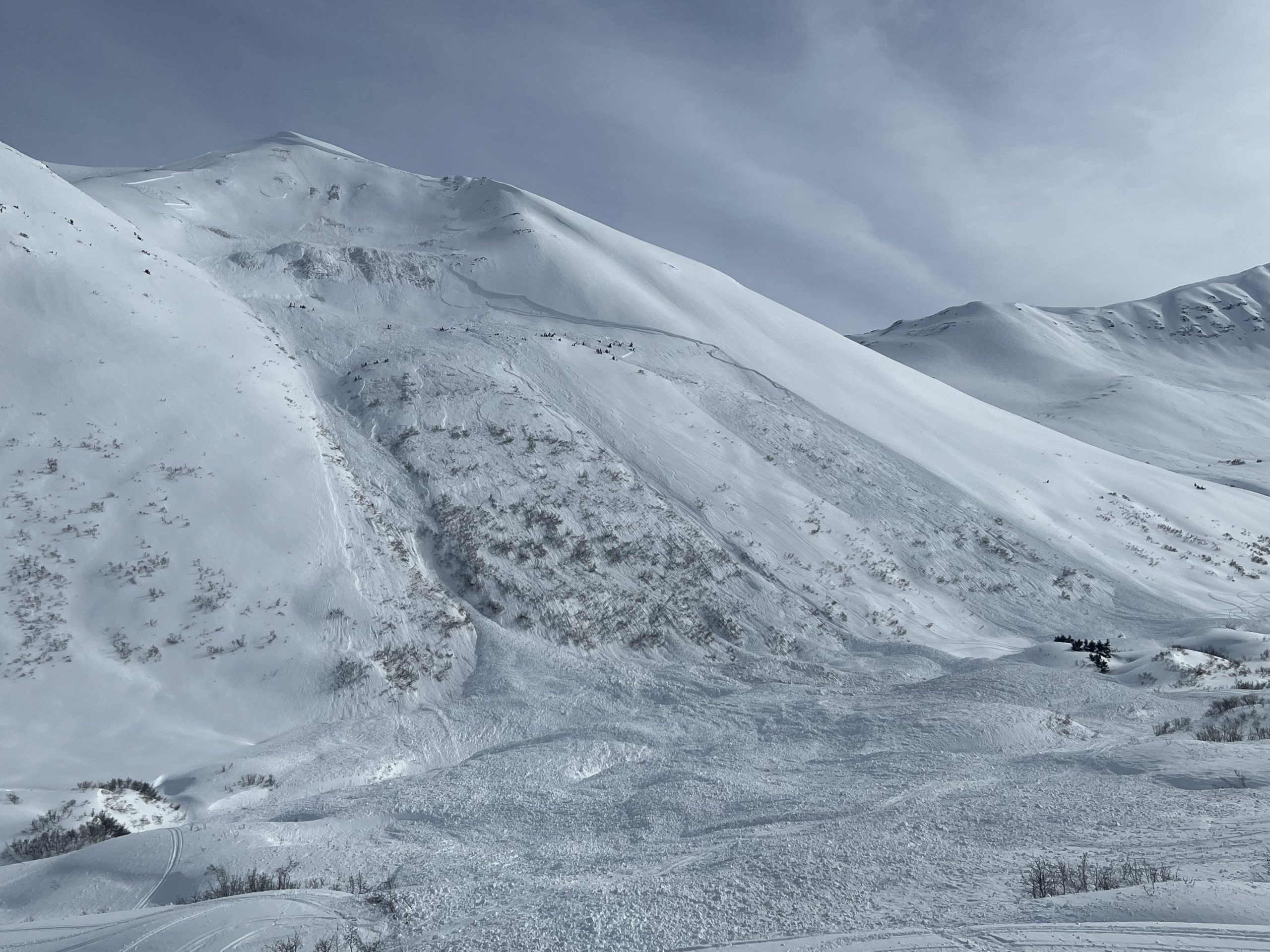
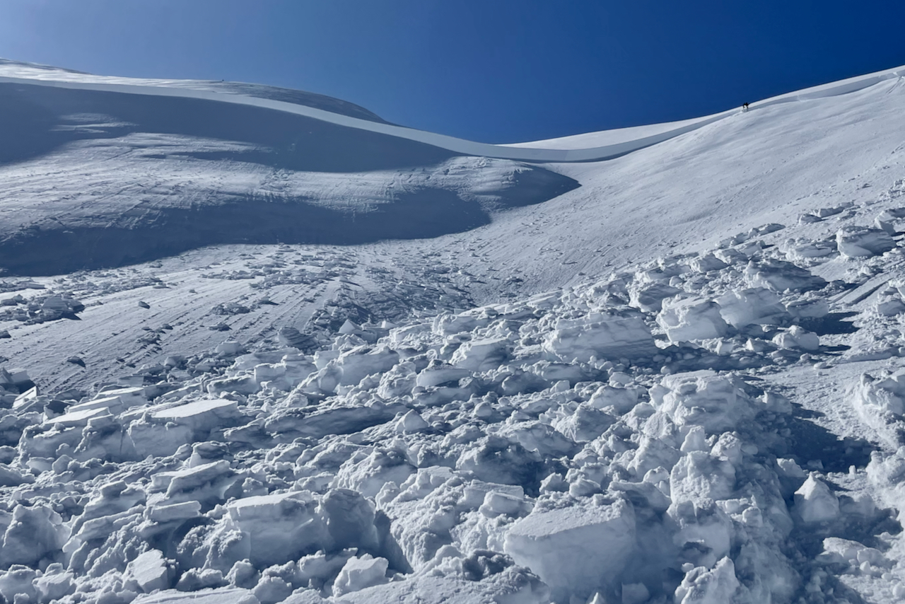
The avalanche danger is CONSIDERABLE above 1000′. Even though we are looking at another day of mild weather, a person can still trigger a very large avalanche on a weak layer buried 4-6′ deep or deeper. We have seen multiple avalanches failing over 1000′ wide and running thousands of vertical feet since Friday, and similar activity is possible today. The only way to avoid this problem is with cautious terrain choices, avoiding traveling on or below steep slopes.

The danger is MODERATE below 1000′. It is less likely a person can trigger an avalanche, but there is still danger from large avalanches running into valley bottoms.

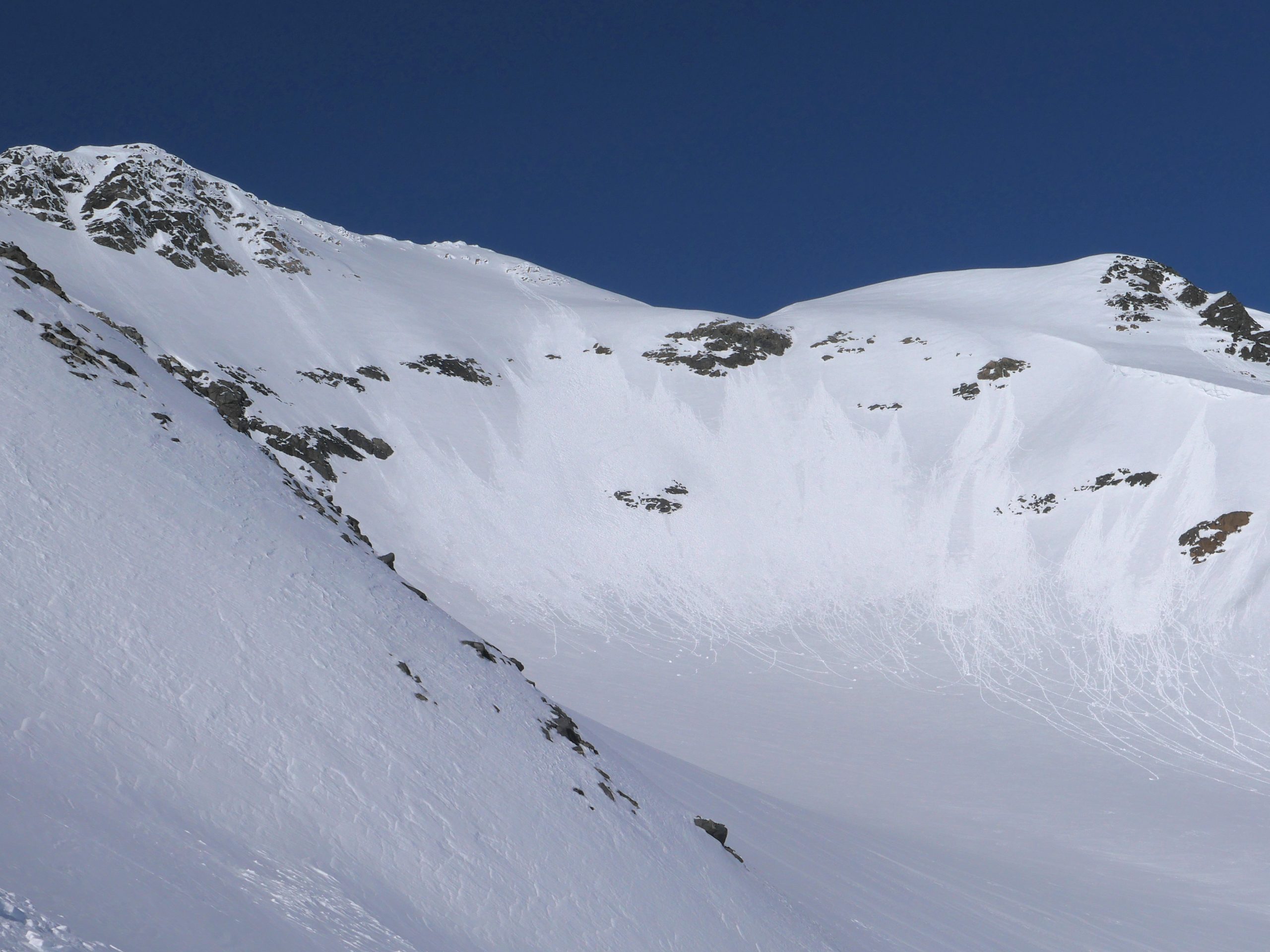
SUMMIT LAKE / LOST LAKE / SEWARD: These areas also have a weak snowpack that has produced large avalanches in the past week. Similar cautious terrain use is advised around the periphery of our forecast zone.

Special Announcements

Support the avalanche forecast with Pick.Click.Give! 
Our Friends group funds 50% of our operating budget, forecaster salaries, and safety equipment to ensure professional, daily avalanche advisories all winter for the Chugach National Forest. The deadline is March 31, so follow these instructions today to support your daily avalanche forecast with your PFD!

Tue, March 28th, 2023
Alpine
Above 2,500'
3 - Considerable
Avalanche risk
Treeline
1,000'-2,500'
3 - Considerable
Avalanche risk
Below Treeline
Below 1,000'
2 - Moderate
Avalanche risk
0 - No Rating
1 - Low
2 - Moderate
3 - Considerable
4 - High
5 - Extreme
Avalanche risk Avalanche risk Avalanche risk Avalanche risk Avalanche risk
Travel Advice Generally safe avalanche conditions. Watch for unstable snow on isolated terrain features. Heightened avalanche conditions on specific terrain features. Evaluate snow and terrain carefully; identify features of concern. Dangerous avalanche conditions. Careful snowpack evaluation, cautious route-finding, and conservative decision-making essential. Very dangerous avalanche conditions. Travel in avalanche terrain not recommended. Extraordinarily dangerous avalanche conditions. Avoid all avalanche terrain.
Likelihood of Avalanches Natural and human-triggered avalanches unlikely. Natural avalanches unlikely; human-triggered avalanches possible. Natural avalanches possible; human-triggered avalanches likely. Natural avalanches likely; human-triggered avalanches very likely. Natural and human-triggered avalanches certain.
Avalanche Size and Distribution Small avalanches in isolated areas or extreme terrain. Small avalanches in specific areas; or large avalanches in isolated areas. Small avalanches in many areas; or large avalanches in specific areas; or very large avalanches in isolated areas. Large avalanches in many areas; or very large avalanches in specific areas. Very large avalanches in many areas.
Recent Avalanches

After three days in a row of very large avalanches, we did not hear of any new activity yesterday. Thank you to all of the groups for sharing details from the big avalanches over the weekend. We’ve updated the info from the large avalanche up Palmer Creek Sunday, details here.

Avalanche Problem 1
  • Deep Persistent Slabs
    Deep Persistent Slabs
  • Aspect/Elevation
  • Certain
    Very Likely
    Likely
    Possible
    Unlikely
    Likelihood
  • Historic (D4-5)
    Very Large (D3)
    Large (D2)
    Small (D1)
    Size
Deep Persistent Slabs
Deep Persistent Slab avalanches are the release of a thick cohesive layer of hard snow (a slab), when the bond breaks between the slab and an underlying persistent weak layer deep in the snowpack. The most common persistent weak layers involved in deep, persistent slabs are depth hoar or facets surrounding a deeply buried crust. Deep Persistent Slabs are typically hard to trigger, are very destructive and dangerous due to the large mass of snow involved, and can persist for months once developed. They are often triggered from areas where the snow is shallow and weak, and are particularly difficult to forecast for and manage.

Aspect/Elevation of the Avalanche Problem
Specialists develop a graphic representation of the potential distribution of a particular avalanche problem across the topography. This aspect/elevation rose is used to indicate where the particular avalanche problem is thought to exist on all elevation aspects. Areas where the avalanche problem is thought to exist are colored grey, and it is less likely to be encountered in areas colored white.

Likelihood of Avalanches
Terms such as "unlikely", "likely", and "certain" are used to define the scale, with the chance of triggering or observing avalanches increasing as we move up the scale. For our purposes, "Unlikely" means that few avalanches could be triggered in avalanche terrain and natural avalanches are not expected. "Certain" means that humans will be able to trigger avalanches on many slopes, and natural avalanches are expected.

Size of Avalanches
Avalanche size is defined by the largest potential avalanche, or expected range of sizes related to the problem in question. Assigned size is a qualitative estimate based on the destructive classification system and requires specialists to estimate the harm avalanches may cause to hypothetical objects located in the avalanche track (AAA 2016, CAA 2014). Under this schema, "Small" avalanches are not large enough to bury humans and are relatively harmless unless they carry people over cliffs or through trees or rocks. Moving up the scale, avalanches become "Large" enough to bury, injure, or kill people. "Very Large" avalanches may bury or destroy vehicles or houses, and "Historic" avalanches are massive events capable of altering the landscape.

Signal Word Size (D scale) Simple Descriptor
Small 1 Unlikely to bury a person
Large 2 Can bury a person
Very Large 3 Can destroy a house
Historic 4 & 5 Can destroy part or all of a village
More info at Avalanche.org

After three days in a row of big scary avalanches breaking deep in the snowpack, we were very happy to go all day yesterday without hearing about any new activity. Unfortunately, this probably has more to do with the fact that there were fewer people out rather than a healing snowpack. The weak layer of facets that was buried starting back on March 14 is going to take some time before we can trust it. Here is what you should know about the avalanche problem we are currently dealing with:

  1. It’s big. Over the weekend we saw multiple very large avalanches failing on the same layer. If you haven’t already, it is worth taking the time to look through the observations of the avalanches on in the Skookum Valley, Sunburst, Seattle Ridge, and Palmer Creek. These avalanches have been over 1000′ wide, running thousands of vertical feet, and failing 6′ deep or deeper in some cases. We saw multiple avalanches triggered remotely from low angle terrain connected to steeper slopes. In some cases the group that triggered the avalanche was up to a half mile away when they triggered it. Luckily nobody has been caught in any of the recent avalanches.
  2. It’s difficult to assess. At this point, the layer of concern is buried anywhere from 4-6′ deep or deeper on average. That makes it hard enough just to dig down and find it, and even harder to do any kind of test to assess it. Given the widespread activity we have seen lately, it is best to assume the problem exists if you are traveling in our advisory area.
  3. It will take time to heal. These persistent weak layers get their name because they take a long time to go away. For now, it is still clearly a problem that will be driving our terrain choices for the days to come.

Given the challenging snowpack we are dealing with, the only way to truly manage the problem is with cautious terrain choices. You can avoid the problem by avoiding traveling on or below steep terrain. Remember, we have seen multiple very large avalanches triggered from low-angle terrain connected to steeper slopes so be mindful of what is above you.

Very large skier-triggered avalanche in Palmer Creek on Sunday. Thank you to multiple groups for writing in and sharing details. 03.26.2023

This is just a portion of one of the three big avalanches triggered at the same time from a half mile away on the back side of Seattle Ridge on Saturday. Photo 03.25.2023


Avalanche Problem 2
  • Wet Loose
    Wet Loose
  • Aspect/Elevation
  • Certain
    Very Likely
    Likely
    Possible
    Unlikely
    Likelihood
  • Historic (D4-5)
    Very Large (D3)
    Large (D2)
    Small (D1)
    Size
Wet Loose
Wet Loose avalanches are the release of wet unconsolidated snow or slush. These avalanches typically occur within layers of wet snow near the surface of the snowpack, but they may quickly gouge into lower snowpack layers. Like Loose Dry Avalanches, they start at a point and entrain snow as they move downhill, forming a fan-shaped avalanche. Other names for loose-wet avalanches include point-release avalanches or sluffs. Loose Wet avalanches can trigger slab avalanches that break into deeper snow layers.

Aspect/Elevation of the Avalanche Problem
Specialists develop a graphic representation of the potential distribution of a particular avalanche problem across the topography. This aspect/elevation rose is used to indicate where the particular avalanche problem is thought to exist on all elevation aspects. Areas where the avalanche problem is thought to exist are colored grey, and it is less likely to be encountered in areas colored white.

Likelihood of Avalanches
Terms such as "unlikely", "likely", and "certain" are used to define the scale, with the chance of triggering or observing avalanches increasing as we move up the scale. For our purposes, "Unlikely" means that few avalanches could be triggered in avalanche terrain and natural avalanches are not expected. "Certain" means that humans will be able to trigger avalanches on many slopes, and natural avalanches are expected.

Size of Avalanches
Avalanche size is defined by the largest potential avalanche, or expected range of sizes related to the problem in question. Assigned size is a qualitative estimate based on the destructive classification system and requires specialists to estimate the harm avalanches may cause to hypothetical objects located in the avalanche track (AAA 2016, CAA 2014). Under this schema, "Small" avalanches are not large enough to bury humans and are relatively harmless unless they carry people over cliffs or through trees or rocks. Moving up the scale, avalanches become "Large" enough to bury, injure, or kill people. "Very Large" avalanches may bury or destroy vehicles or houses, and "Historic" avalanches are massive events capable of altering the landscape.

Signal Word Size (D scale) Simple Descriptor
Small 1 Unlikely to bury a person
Large 2 Can bury a person
Very Large 3 Can destroy a house
Historic 4 & 5 Can destroy part or all of a village
More info at Avalanche.org

Once again, the potential for loose wet activity will depend on how much sun pokes through the clouds today. Yesterday things were just starting to get warm enough to see some rollerballs and small wet loose avalanches on the steepest solar aspects before the clouds moved in later in the afternoon. Be on the lookout for the onset of activity on steep southerly terrain first, especially where there are rocks or trees heating up in the afternoon. Be aware for deteriorating stability if you start to notice sun crusts softening, or dry snow becoming moist on solar aspects. Wet loose avalanches are fairly easy to avoid on their own, but they have the potential to trigger the bigger, deeper avalanches mentioned in problem 1 above.

Roller balls and small wet loose activity seen yesterday afternoon north of Girdwood. 03.27.2023

Weather
Tue, March 28th, 2023

Yesterday: Skies were mostly sunny until high clouds moved in later in the afternoon. Winds were light out of the east at around 5 mph gusting 10 mph, switching to the southwest in the afternoon. High temperatures were in the upper 30’s F at low elevations and mid 20’s F at ridgetops. The coldest temperatures in the past 24 hours were yesterday morning, with lows in the upper teens to mid 20’s F. We did not record any precipitation yesterday.

Today: We should see partly to mostly cloudy skies with light westerly winds. High temperatures will be in the mid 20’s F at upper elevations to mid 30’s F at lower elevations, with lows dropping back to the mid teens to low 20’s F. We may see some flurries as a system approaches from the west, but no accumulation is expected today.

Tomorrow: Cloud cover will be building through the day, with chances for precipitation increasing beginning in the afternoon. We will likely see 2-4” snow overnight tomorrow night, with snow levels staying down at sea level. Winds will switch back to the east and increase during the day, starting light and bumping up to 10-15 mph with gusts of 20-25 in the afternoon and continuing to increase overnight. High temperatures should be in the mid 20’s to low 30’s F with lows in the low to mid 20’s F.

PRECIPITATION 24-hour data (6am – 6am)

Temp Avg (F) Snow (in) Water (in) Snow Depth (in)
Center Ridge (1880′) 29 0 0 100
Summit Lake (1400′) 25 0 0 49
Alyeska Mid (1700′) 30 0 0 91
Bear Valley – Portage (132′) 27 0 0

RIDGETOP 24-hour data (6am – 6am)

Temp Avg (F) Wind Dir Wind Avg (mph) Wind Gust (mph)
Sunburst (3812′) 21 E-W* 3 15
Seattle Ridge (2400′) 24 S 4 8

*Winds shifted from the east to the west late yesterday afternoon. 

Observations
Recent Observations for Turnagain Pass
Date Region Location
03/27/24 Turnagain Observation: Tincan Trees
03/26/24 Turnagain Observation: Cornbiscuit
03/25/24 Turnagain Observation: Tincan
03/22/24 Turnagain Avalanche: Magnum Northwest Aspect
03/21/24 Turnagain Observation: Sunburst
03/21/24 Turnagain Observation: Tincan Proper North Aspect
03/20/24 Turnagain Avalanche: Seattle Creek Drainage
03/19/24 Turnagain Observation: Tincan CFR
03/18/24 Turnagain Avalanche: Tincan – Eddies – Seattle Ridge
03/18/24 Turnagain Observation: Tincan
Riding Areas

The riding areas page has moved. Please click here & update your bookmarks.


Subscribe to Turnagain Pass
Avalanche Forecast by Email

This is a general backcountry avalanche advisory issued for Turnagain Arm with Turnagain Pass as the core advisory area. This advisory does not apply to highways, railroads or operating ski areas.