Turnagain Pass RSS

Archives
ARCHIVED - Forecasts expire after 24 hours.
Issued
Wed, March 24th, 2021 - 7:00AM
Expires
Thu, March 25th, 2021 - 7:00AM
Forecaster
Andrew Schauer
Avalanche risk The Bottom Line

The avalanche danger remains MODERATE today, and it is still possible to trigger an avalanche on a persistent weak layer in the upper 1-3′ of the snowpack. Steep slopes with relatively stiff snow near the surface are the most likely places to find unstable snow. In addition to our persistent slab problem, moderate winds overnight have created isolated small wind slabs that will be sensitive to triggers today. Avoid wind-loaded slopes today, and be sure to follow safe travel protocol if you are trying to get into steeper terrain.

Wed, March 24th, 2021
Alpine
Above 2,500'
2 - Moderate
Avalanche risk
Treeline
1,000'-2,500'
2 - Moderate
Avalanche risk
Below Treeline
Below 1,000'
2 - Moderate
Avalanche risk
0 - No Rating
1 - Low
2 - Moderate
3 - Considerable
4 - High
5 - Extreme
Avalanche risk Avalanche risk Avalanche risk Avalanche risk Avalanche risk
Travel Advice Generally safe avalanche conditions. Watch for unstable snow on isolated terrain features. Heightened avalanche conditions on specific terrain features. Evaluate snow and terrain carefully; identify features of concern. Dangerous avalanche conditions. Careful snowpack evaluation, cautious route-finding, and conservative decision-making essential. Very dangerous avalanche conditions. Travel in avalanche terrain not recommended. Extraordinarily dangerous avalanche conditions. Avoid all avalanche terrain.
Likelihood of Avalanches Natural and human-triggered avalanches unlikely. Natural avalanches unlikely; human-triggered avalanches possible. Natural avalanches possible; human-triggered avalanches likely. Natural avalanches likely; human-triggered avalanches very likely. Natural and human-triggered avalanches certain.
Avalanche Size and Distribution Small avalanches in isolated areas or extreme terrain. Small avalanches in specific areas; or large avalanches in isolated areas. Small avalanches in many areas; or large avalanches in specific areas; or very large avalanches in isolated areas. Large avalanches in many areas; or very large avalanches in specific areas. Very large avalanches in many areas.
Avalanche Problem 1
  • Persistent Slabs
    Persistent Slabs
  • Certain
    Very Likely
    Likely
    Possible
    Unlikely
    Likelihood
  • Historic (D4-5)
    Very Large (D3)
    Large (D2)
    Small (D1)
    Size
Persistent Slabs
Persistent Slab avalanches are the release of a cohesive layer of snow (a slab) in the middle to upper snowpack, when the bond to an underlying persistent weak layer breaks. Persistent layers include: surface hoar, depth hoar, near-surface facets, or faceted snow. Persistent weak layers can continue to produce avalanches for days, weeks or even months, making them especially dangerous and tricky. As additional snow and wind events build a thicker slab on top of the persistent weak layer, this avalanche problem may develop into a Deep Persistent Slab.

Likelihood of Avalanches
Terms such as "unlikely", "likely", and "certain" are used to define the scale, with the chance of triggering or observing avalanches increasing as we move up the scale. For our purposes, "Unlikely" means that few avalanches could be triggered in avalanche terrain and natural avalanches are not expected. "Certain" means that humans will be able to trigger avalanches on many slopes, and natural avalanches are expected.

Size of Avalanches
Avalanche size is defined by the largest potential avalanche, or expected range of sizes related to the problem in question. Assigned size is a qualitative estimate based on the destructive classification system and requires specialists to estimate the harm avalanches may cause to hypothetical objects located in the avalanche track (AAA 2016, CAA 2014). Under this schema, "Small" avalanches are not large enough to bury humans and are relatively harmless unless they carry people over cliffs or through trees or rocks. Moving up the scale, avalanches become "Large" enough to bury, injure, or kill people. "Very Large" avalanches may bury or destroy vehicles or houses, and "Historic" avalanches are massive events capable of altering the landscape.

Signal Word Size (D scale) Simple Descriptor
Small 1 Unlikely to bury a person
Large 2 Can bury a person
Very Large 3 Can destroy a house
Historic 4 & 5 Can destroy part or all of a village
More info at Avalanche.org

It is looking like we will have another day of quiet weather before things get a little more active tonight. For now, the avalanche conditions have not changed. We are still concerned with the possibility of triggering an avalanche on a weak layer of buried surface hoar and near-surface facets around a foot deep. These layers are slowly gaining strength, but multiple human-triggered avalanches in the past three days (details here and here) are a clear sign that the snowpack is still conducive to persistent slab avalanches. Slopes that have been previously wind-loaded are the most suspect, with stiff snow sitting on top of weak snow.

The travel advice today is the same story we have been talking about for the past 10 days. That lingering possibility of triggering an avalanche large enough to bury a person means we need to adjust terrain use accordingly. Avoid slopes with terrain traps that could make even a small avalanche have severe consequences– things like rocks, cliffs, trees, or gullies in the avalanche path. If you are trying to move into steeper terrain, be sure you are traveling with a competent partner (with a beacon, shovel, and probe), and only exposing one person at a time to avalanche terrain, with partners watching from safe zones out of the line of fire.

Keep your fingers crossed for more snow tonight. It’s looking like this one is going to favor the Front Range and Hatcher Pass, but we could get a modest reset, with 6-8″ near Girdwood and a couple inches at Turnagain Pass.

Wind Slabs: Overnight winds blowing out of the west at 15-20 mph have created small wind slabs that may be easily triggered today. These will be more of an issue at upper elevations, especially immediately below ridgelines, in cross-loaded gullies, and below convexities. These fresh wind slabs will most likely be sitting on top of weak facets, making them a little easier to trigger. Be on the lookout for indications of wind loading, including stiff snow on the surface or a hollow, ‘punchy’ feeling slab.

Loose snow avalanches: Steep slopes that have been sheltered from the wind have up to a foot of loose snow sitting on top of firm surfaces. It will be easy to trigger dry loose avalanches (sluffs) today, and they can pick up enough volume and speed to carry a person. If the sun stays out long enough, we may see some wet loose activity as well. While it is unlikely they will be big enough to bury you, they can be dangerous if they drag you into terrain traps like cliffs, trees, rocks, or gullies.

Nerd alert! If you’re curious about the processes driving the near-surface faceting that is leaving us with persistent problems, this article has some good info.

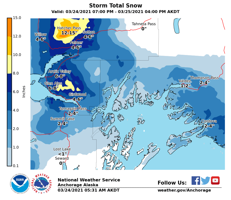
Predicted storm totals starting tonight through tomorrow. It’s looking like this one is going to head towards Hatcher Pass, but hopefully we will get a little out of it too.

Weather
Wed, March 24th, 2021

Yesterday: Skies gradually cleared after a brief period of light snowfall in the morning, with high temperatures in the mid teens to upper 20’s F and overnight lows in the low to upper teens F. Winds were light out of the west at 5-15 mph.

Today: We will start the day with a few clouds, but cloud cover is expected to increase throughout the day as unstable weather approaches this evening. High temperatures are expected in the low 20’s to low 30’s F. Ridgetop winds are expected at 15-20 mph out of the west for a few hours this morning, but they should quickly calm to 5-10 mph for most of the day. Chances for precipitation increase tonight.

Tomorrow: Snow is expected to return to southcentral Alaska tonight, but it is looking like this round will favor Hatcher Pass. We still might see 6-8” near Girdwood, and only 2-4” at Turnagain Pass. The good news is that we are looking at cool enough temperatures to get snow down to sea level. Overnight lows are expected in the low to upper 20’s F, with highs tomorrow in the low 20’s to low 30’s F. Winds are expected to remain light out of the west at 5-10 mph.

PRECIPITATION 24-hour data (6am – 6am)

Temp Avg (F) Snow (in) Water (in) Snow Depth (in)
Center Ridge (1880′) 24 0 0 110
Summit Lake (1400′) 22 0 0 45
Alyeska Mid (1700′) 22 0 0 113

RIDGETOP 24-hour data (6am – 6am)

Temp Avg (F) Wind Dir Wind Avg (mph) Wind Gust (mph)
Sunburst (3812′) 12 W 8 29
Seattle Ridge (2400′) 18 NW 5 15


Observations
Recent Observations for Turnagain Pass
Date Region Location
04/23/24 Turnagain Observation: Turnagain Sunny Side
04/21/24 Turnagain Observation: Bertha Creek
04/20/24 Turnagain Avalanche: Spokane Creek
04/16/24 Turnagain Observation: Cornbiscuit
04/15/24 Turnagain Observation: Taylor Pass
04/15/24 Turnagain Observation: Seward Highway – Tern Lake to Portage
04/14/24 Turnagain Observation: Sunburst
04/14/24 Turnagain Observation: Turnagain Pass Snomo
04/13/24 Turnagain Observation: Spokane Creek
04/11/24 Turnagain Observation: Tincan
Riding Areas

The riding areas page has moved. Please click here & update your bookmarks.


Subscribe to Turnagain Pass
Avalanche Forecast by Email

This is a general backcountry avalanche advisory issued for Turnagain Arm with Turnagain Pass as the core advisory area. This advisory does not apply to highways, railroads or operating ski areas.