The avalanche danger is CONSIDERABLE above 1000′ due to sustained winds and plenty of snow available for transport. Human triggered wind slabs 2-3′ deep will be likely and may be triggered remotely. Natural avalanches and cornice falls will be possible. Watch for blowing snow, shooting cracks and recent avalanches. Cautious route-finding and conservative decision-making are essential.
PORTAGE VALLEY and PLACER VALLEY: There is potential for avalanche debris, from a slide occurring above, to run to low elevation terrain. Avoiding gullies and runout zones is recommended.
LOST LAKE/SNUG/SEWARD: The northwest winds are forecast to be stronger in these areas. Watch for blowing snow and pay attention to terrain selection and the potential for natural avalanches.
Special Announcements
Heading to Hatcher Pass? Be sure to check the Thursday Conditions Summary at hpavalanche.org.
Thu, March 11th, 2021
Alpine
Above 2,500'
3 - Considerable
Treeline
1,000'-2,500'
3 - Considerable
Below Treeline
Below 1,000'
2 - Moderate
0 - No Rating
1 - Low
2 - Moderate
3 - Considerable
4 - High
5 - Extreme
Travel Advice
Generally safe avalanche conditions. Watch for unstable snow on isolated terrain features.
Heightened avalanche conditions on specific terrain features. Evaluate snow and terrain carefully; identify features of concern.
Natural avalanches likely; human-triggered avalanches very likely.
Natural and human-triggered avalanches certain.
Avalanche Size and Distribution
Small avalanches in isolated areas or extreme terrain.
Small avalanches in specific areas; or large avalanches in isolated areas.
Small avalanches in many areas; or large avalanches in specific areas; or very large avalanches in isolated areas.
Large avalanches in many areas; or very large avalanches in specific areas.
Very large avalanches in many areas.
Avalanche Problem 1
Wind Slabs
Certain
Very Likely
Likely
Possible
Unlikely
Likelihood
Historic (D4-5)
Very Large (D3)
Large (D2)
Small (D1)
Size
Wind Slabs
Wind Slab avalanches are the release of a cohesive layer of snow (a slab) formed by the wind. Wind typically transports snow from the upwind sides of terrain features and deposits snow on the downwind side. Wind slabs are often smooth and rounded and sometimes sound hollow, and can range from soft to hard. Wind slabs that form over a persistent weak layer (surface hoar, depth hoar, or near-surface facets) may be termed Persistent Slabs or may develop into Persistent Slabs.
Likelihood of Avalanches
Terms such as "unlikely", "likely", and "certain" are used to define the scale, with the chance of triggering or observing
avalanches increasing as we move up the scale. For our purposes, "Unlikely" means that few avalanches could be triggered in avalanche terrain and
natural avalanches are not expected. "Certain" means that humans will be able to trigger avalanches on many slopes, and natural avalanches are expected.
Size of Avalanches
Avalanche size is defined by the largest potential avalanche, or expected range of sizes related to the problem in question.
Assigned size is a qualitative estimate based on the destructive classification system and requires specialists to estimate the harm avalanches may cause to
hypothetical objects located in the avalanche track (AAA 2016, CAA 2014). Under this schema, "Small" avalanches are not large enough to bury humans and are
relatively harmless unless they carry people over cliffs or through trees or rocks. Moving up the scale, avalanches become "Large" enough to bury, injure,
or kill people. "Very Large" avalanches may bury or destroy vehicles or houses, and "Historic" avalanches are massive events capable of altering the landscape.
Thumbs up for snow and thumbs down for wind. Human triggered wind slabs, 2-3′ deep, will be likely in steep wind-loaded terrain, especially on unsupported slopes and in cross-loaded gullies. Yesterday’s storm brought about a foot of snow (1″of SWE) to the forecast area with periods of snow falling around an inch per hour. After the mostly dry month of February it really felt like a welcome return to winter. With the snowfall the winds were easterly 10-20 mph with gusts into the 30s. They were definitely strong enough to blow snow around and form wind slabs as observers noted. Last night the winds shifted to the northwest and are forecast to blow 15-30 mph with gusts into the 40s today. As we have mentioned before, this wind flow direction is tricky for Turnagain Pass. It can funnel through the Pass from the south and load north aspects on the non-motorized side, while at the same time load the SE face of Seattle Ridge. It can also split around the Pass and not affect much of the terrain in the heart of Turnagain at all. This wind pattern also increases through channeled terrain and can be more pronounced in Crow Pass and Portage. Because of the flip flop in wind direction there may be wind slab on all aspects. Remember, expect any wind slab you find to be sitting on weak faceted snow and/or surface hoar and thatthey may be triggered remotely. The wind slabs may also be on a somewhat of spectrum from really stiff and easy to identify in the Alpine to softer slabs that are just slightly more cohesive than the weak layer below at lower elevations.
What to look for if you’re headed out today:
Areas with current wind-loading (Northwest winds should blow all day), natural avalanches and cornice falls are possible. Pay attention to what terrain is above you.
Slabs lower on slopes from cross-loading, especially with the winds funneling through Turnagain pass from the south.
Stiff snow over softer snow (punchy snow), does it feel slabby?
Cracks shooting from your skis or machine
Whumpfing (collapsing of the snowpack into those recently buried facets/surface hoar underneath the new snow)
Avoid cornices. They may be tender and easy to trigger
Storm slabs: Yesterday below approximately 1400′, the snow that fell was upside down with heavier/wetter snow on top of drier colder snow and you may find some storm slabs in areas out of the wind. However, the cold temperatures overnight may have helped this situation.
Persistent slabs: There is also a chance that a wind slab avalanche triggered near the surface overloads the older weak layers in the snowpack and steps down creating a larger avalanche. This is another reason for extra caution today.
Sluffs: Steep slopes that are sheltered from the wind have a foot of new soft snow and a few inches of loose facets from before the storm. It will be easy to trigger dry loose avalanches (sluffs) in this terrain.
Sunburst 24 hour Windrose. Note the direction change and the northeast winds 16-25 mph (yesterday’s winds).
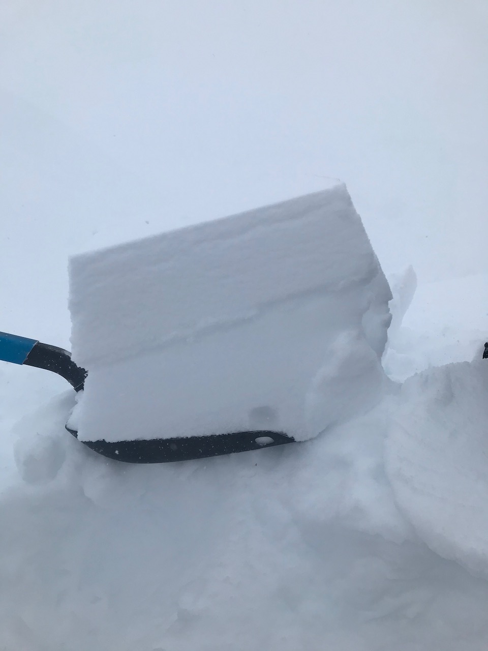
The new snow slid easily on the faceted snow below yesterday in a shovel tilt test. Another 6″ of snow fell on top after this photo was taken. Tincan, 3.10.21.
Weather
Thu, March 11th, 2021
Yesterday: Skies were obscured and snow fell throughout the day with 6-10″ of accumulation. Winds were easterly 10-20 mph with gusts into the 30s. Temperatures were in the mid 20°Fs to mid 30°Fs. Around 8 pm the precipitation shut off and the winds shifted to the west/northwest 10-15 mph gusting into the 20s. Overnight temperatures dropped to single digits in the Alpine and to the low 20°Fs near sea level.
Today: Skies will be cloudy and there is a chance of light snow showers. Winds will be from the northwest 15-35 mph with gusts into the 40s. Ridgetop temperatures will be in the single digits and it will be in the teens to low 20°Fs near sea level. Overnight northwest winds will ease a little and skies will become partly cloudy. Temperatures will be in the single digits to few degrees below 0°F.
Tomorrow: Skies will become mostly clear. Northwest winds continue, 5-15 mph with gusts into the 20s. Temperatures will be in the single digits to high teens. The weekend looks to be mostly sunny with clouds building in the late afternoon on Sunday as the next weather system approaches.
This is a general backcountry avalanche advisory issued for Turnagain Arm with Turnagain Pass as the core advisory area.
This advisory does not apply to highways, railroads or operating ski areas.