Turnagain Pass RSS

Archives
ARCHIVED - Forecasts expire after 24 hours.
Issued
Mon, March 7th, 2022 - 7:00AM
Expires
Tue, March 8th, 2022 - 7:00AM
Forecaster
Andrew Schauer
Avalanche risk The Bottom Line

The avalanche danger is MODERATE above 1000′ today. It is possible a person could trigger an avalanche 1-3′ deep or deeper below the new snow from the end of last week, which fell on firm crusts, buried surface hoar, and near-surface facets. Approach steep terrain carefully today, and keep in mind the very real possibility of triggering an avalanche big enough to bury a person. The danger is LOW below 1000′.

PORTAGE/PLACER: These areas received the most snow during the most recent storm, and that came with a widespread natural cycle. There were multiple human-triggered avalanches in the Skookum/Squirrel areas on Thursday, and we have very limited info since the end of the storm. This is a potentially dangerous setup that needs to be approached with caution.

Mon, March 7th, 2022
Alpine
Above 2,500'
2 - Moderate
Avalanche risk
Treeline
1,000'-2,500'
2 - Moderate
Avalanche risk
Below Treeline
Below 1,000'
1 - Low
Avalanche risk
0 - No Rating
1 - Low
2 - Moderate
3 - Considerable
4 - High
5 - Extreme
Avalanche risk Avalanche risk Avalanche risk Avalanche risk Avalanche risk
Travel Advice Generally safe avalanche conditions. Watch for unstable snow on isolated terrain features. Heightened avalanche conditions on specific terrain features. Evaluate snow and terrain carefully; identify features of concern. Dangerous avalanche conditions. Careful snowpack evaluation, cautious route-finding, and conservative decision-making essential. Very dangerous avalanche conditions. Travel in avalanche terrain not recommended. Extraordinarily dangerous avalanche conditions. Avoid all avalanche terrain.
Likelihood of Avalanches Natural and human-triggered avalanches unlikely. Natural avalanches unlikely; human-triggered avalanches possible. Natural avalanches possible; human-triggered avalanches likely. Natural avalanches likely; human-triggered avalanches very likely. Natural and human-triggered avalanches certain.
Avalanche Size and Distribution Small avalanches in isolated areas or extreme terrain. Small avalanches in specific areas; or large avalanches in isolated areas. Small avalanches in many areas; or large avalanches in specific areas; or very large avalanches in isolated areas. Large avalanches in many areas; or very large avalanches in specific areas. Very large avalanches in many areas.
Recent Avalanches

Turnagain Pass: Skiers triggered an avalanche on the Eddie’s Headwall remotely, from over 100′ away from the slope that released (more details here). There were also multiple small slabs that released in the wind-loaded gullies on the front side of Seattle Ridge.

Johnson Pass/Lynx Creek: A group of skiers triggered an avalanche on a wind-loaded slope near the top of the Groundhog Creek drainage. The skier that triggered the avalanche was the third person on the slope. Nobody was caught or carried in the avalanche. More details in this observation.

Girdwood Valley: There were multiple natural avalanches in the Raggedtop area (details here). There was also a large skier-triggered avalanche in the Girdwood valley that propagated very wide. Nobody was caught or carried.

Skier-triggered avalanche in the Johnson Pass/Lynx Creek area. Photo: Mike Records. 03.06.2022

Crowns from solar-triggered avalanches in the Crow Creek area yesterday. Photo: Allen Dahl. 03.06.2022


Avalanche Problem 1
  • Storm Slabs
    Storm Slabs
  • Certain
    Very Likely
    Likely
    Possible
    Unlikely
    Likelihood
  • Historic (D4-5)
    Very Large (D3)
    Large (D2)
    Small (D1)
    Size
Storm Slabs
Storm Slab avalanches are the release of a cohesive layer (a slab) of new snow that breaks within new snow or on the old snow surface. Storm-slabs typically last between a few hours and few days (following snowfall). Storm-slabs that form over a persistent weak layer (surface hoar, depth hoar, or near-surface facets) may be termed Persistent Slabs or may develop into Persistent Slabs.

Likelihood of Avalanches
Terms such as "unlikely", "likely", and "certain" are used to define the scale, with the chance of triggering or observing avalanches increasing as we move up the scale. For our purposes, "Unlikely" means that few avalanches could be triggered in avalanche terrain and natural avalanches are not expected. "Certain" means that humans will be able to trigger avalanches on many slopes, and natural avalanches are expected.

Size of Avalanches
Avalanche size is defined by the largest potential avalanche, or expected range of sizes related to the problem in question. Assigned size is a qualitative estimate based on the destructive classification system and requires specialists to estimate the harm avalanches may cause to hypothetical objects located in the avalanche track (AAA 2016, CAA 2014). Under this schema, "Small" avalanches are not large enough to bury humans and are relatively harmless unless they carry people over cliffs or through trees or rocks. Moving up the scale, avalanches become "Large" enough to bury, injure, or kill people. "Very Large" avalanches may bury or destroy vehicles or houses, and "Historic" avalanches are massive events capable of altering the landscape.

Signal Word Size (D scale) Simple Descriptor
Small 1 Unlikely to bury a person
Large 2 Can bury a person
Very Large 3 Can destroy a house
Historic 4 & 5 Can destroy part or all of a village
More info at Avalanche.org

We are looking at one more day of fair weather today, but there is still a very real possibility of triggering an avalanche 1-3′ deep at the interface between the old snow and the the storm snow from last week. The storm buried a variety of suspect surfaces including crusts, surface hoar, and near-surface facets, and we have seen multiple large avalanches since Thursday, including several skier-triggered avalanches yesterday (Take a look at the links in the avalanche activity section of this advisory for more info and photos).

With strong winds alternating between easterly and westerly over the past two days, there are now multiple generations of wind slabs capping these potentially dangerous weak layers. As we move farther out from the last loading event, it is becoming less likely we will see natural avalanches failing on these weak layers, but it is still entirely possible for a person to trigger a large slab avalanche. The distribution of these weak layers is still a little bit fuzzy, but we have seen remotely triggered avalanches on Eddie’s and in the Squirrel/Skookum area, and very wide propagation in the Girdwood Valley. All of these signs point to a reactive layer. It is uncertain just how long this weak layer will remain a problem, but with multiple avalanches yesterday, it is most definitely still a concern today.

The best way to avoid getting caught with a problem like this is to avoid steep slopes entirely. For those with a larger appetite for risk, stepping into steep terrain needs to be done carefully. This means being diligent with your snowpack assessment- taking the time to look for weak interfaces between new and old snow, keeping an eye out for shooting cracks/collapsing, collecting information from smaller test slopes before getting into big terrain. Consider the consequences of getting caught in an avalanche in the terrain you are looking at. With the current potential for human-triggered avalanches, this is not a great time to be getting into high consequence terrain.

Cornices: Cornices are large and dangerous as always right now. Be sure to maintain plenty of space from the edge as you travel along ridgelines, and be sure to limit time spent under them. We may see some more chunks breaking naturally as things heat up once again in the sun today.

Deep Persistent Slab: We know there is poor snowpack structure with deeply buried weak layers of facets in the far northern and southern ends of our advisory are (Crow Pass, Johnson Pass, Lynx Creek, Silvertip Creek), as well as the Summit Lake area. It is unlikely a person will trigger an avalanche on one of these layers today, but not impossible. One more thing to consider while choosing terrain in these zones along the outskirts of our forecast area.

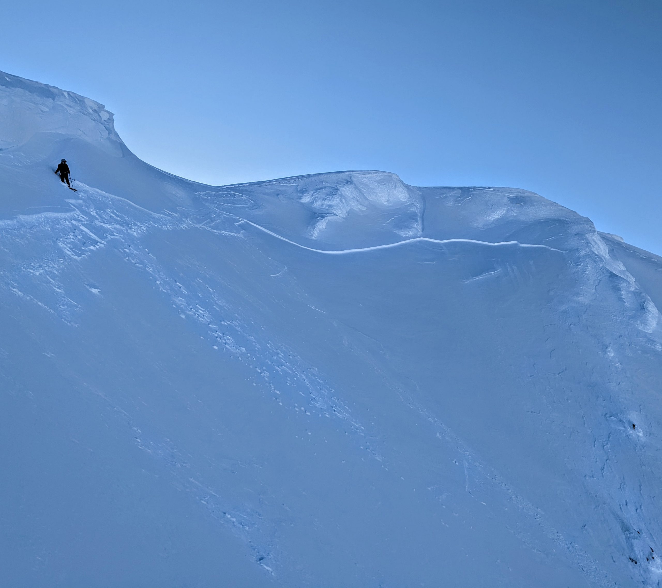
Remote-triggered avalanche on the Eddie’s headwall. The avalanche was triggered just out of frame to the right on the lower bump in the foreground. 03.06.2022
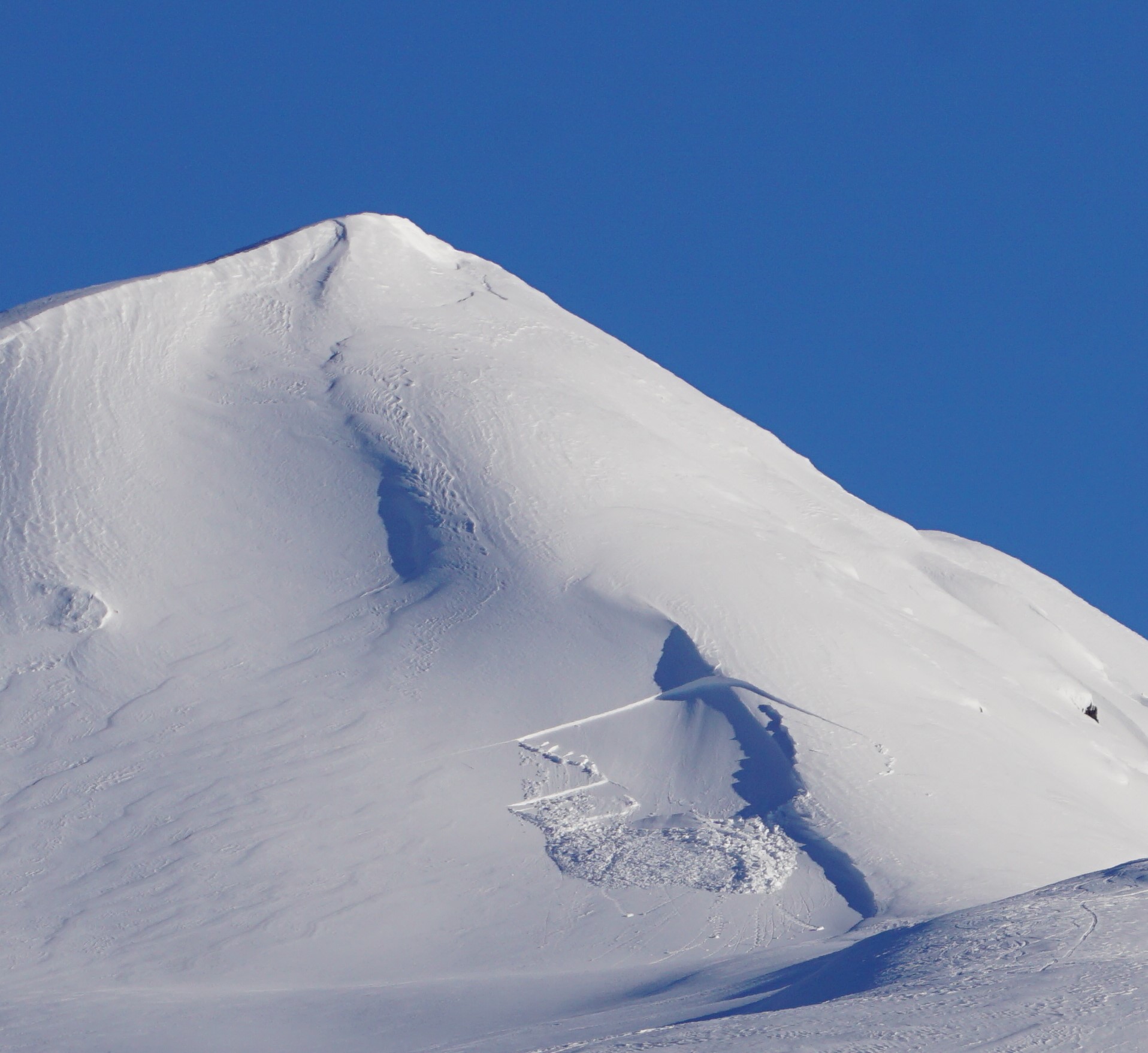
Weather
Mon, March 7th, 2022

Yesterday: What a day! Spectacular sunshine with high temperatures in the upper 20’s to upper 30’s F. Winds were light out of the west for most of the day, switching easterly last night and bumping up to around 10-15 mph. Overnight low temperatures were in the upper teens to low 20’s F.

Today: Another day of mild weather is on the way today, as partly cloudy skies slowly become increasingly cloudy through the day. High temperatures are excpecteed to be in the mid 20’s to low 30’s F, with lows in the upper teens to low 20’s F. Light easterly winds should be around 5-15 mph with gusts of 15-25 mph. No precipitation is expected.

Tomorrow: Cloud cover continues to increase overnight, with mostly cloudy skies tomorrow as the next round of precipitation approaches tomorrow night. Easterly winds will increase slightly to 15-20 mph at ridgetops with highs in the mid to upper 20’s F. No precipitation is expected during the day. Starting Tuesday night we are looking at another round of steady precipitation into the weekend, so be sure to stay tuned for more.

PRECIPITATION 24-hour data (6am – 6am)

Temp Avg (F) Snow (in) Water (in) Snow Depth (in)
Center Ridge (1880′) 29 0 0 96
Summit Lake (1400′) 22 0 0 42
Alyeska Mid (1700′) 31 0 0 N/A

RIDGETOP 24-hour data (6am – 6am)

Temp Avg (F) Wind Dir Wind Avg (mph) Wind Gust (mph)
Sunburst (3812′) 21 W-E* 8 24
Seattle Ridge (2400′) 25 W-E* 4 19

*Winds shifted back to the east yesterday evening between 7 p.m. and 10 p.m.

Observations
Recent Observations for Turnagain Pass
Date Region Location
04/21/24 Turnagain Observation: Bertha Creek
04/20/24 Turnagain Avalanche: Spokane Creek
04/16/24 Turnagain Observation: Cornbiscuit
04/15/24 Turnagain Observation: Taylor Pass
04/15/24 Turnagain Observation: Seward Highway – Tern Lake to Portage
04/14/24 Turnagain Observation: Sunburst
04/14/24 Turnagain Observation: Turnagain Pass Snomo
04/13/24 Turnagain Observation: Spokane Creek
04/11/24 Turnagain Observation: Tincan
04/10/24 Turnagain Avalanche: Seattle Ridge
Riding Areas

The riding areas page has moved. Please click here & update your bookmarks.


Subscribe to Turnagain Pass
Avalanche Forecast by Email

This is a general backcountry avalanche advisory issued for Turnagain Arm with Turnagain Pass as the core advisory area. This advisory does not apply to highways, railroads or operating ski areas.