Turnagain Pass Avalanche Forecast
|
![]() ![]() |
The avalanche danger is MODERATE above 1000′ today. Warm temperatures and mostly sunny skies will make loose avalanches the main concern, and there is a smaller possibility that these loose snow avalanches could pull out bigger slabs on isolated slopes. It is difficult to predict how the snowpack will respond to the first major warming event of the season, so it will be important to pay attention to warning signs and dial back your terrain if you see conditions changing in the heat of the afternoon. The danger will remain LOW below 1000′.
Turnagain Pass Avalanche Awareness Day – 2023: Mark your calendars for Saturday, March 18th, and swing by on your way to or from your backcountry ride or ski!! Test your beacon skills, chow down on hot dogs, and bring your questions. The Alaska Avalanche School will be there along with a chance to demo snowmachines from Alaska Mining and Diving Supply and Anchorage Yamaha and Polaris. More details HERE!
There were two small human-triggered avalanches reported yesterday. One was a skier-triggered slab in the Goldpan area up above Magnum and Cornbiscuit. The avalanche was small and the skier was not caught. The other was a very small snowmachine-triggered slab in Lynx creek, which either occurred Saturday or Sunday.
A group skiing in Pete’s North yesterday observed a large collapse just above treeline. This didn’t lead to an avalanche, but it is the third observation in two weeks noting concerning structure that seems to be confined to Pete’s. We don’t usually forecast for such a specific piece of terrain, but it seems like there is cause for concern in that area right now that doesn’t exist for most of the rest of the advisory area.
Signal Word | Size (D scale) | Simple Descriptor |
Small | 1 | Unlikely to bury a person |
Large | 2 | Can bury a person |
Very Large | 3 | Can destroy a house |
Historic | 4 & 5 | Can destroy part or all of a village |
Temperatures are on the rise again today, and uncertainty is high with just how the snowpack will respond. It is likely we will see some loose snow avalanches as things heat up later in the day. This should start out with rollerballs releasing near rocks and trees, which will likely start to entrain loose snow at the surface as the snowpack warms. This type of activity was observed yesterday, and we should expect more of the same today. These loose snow avalanches should be on the smaller side, and can easily be managed by avoiding steep southerly terrain later in the day. The first sign of deteriorating conditions will be those rollerballs- small chunks of snow rolling down steep terrain. If you notice that kind of activity, it is time to move to shaded terrain.
The bigger question will be how the snowpack responds just below the surface. There is a chance that a loose snow avalanche near the surface could pull out a bigger slab. This may be a stubborn wind slab that formed towards the end of last week, or even one of those weak layers in the upper 2-3′ of the snowpack that have been mostly unreactive. Yesterday we noted two small human-triggered avalanches in steep alpine terrain, and similar activity will be possible again today. This is the beginning of the first major warming event of the season, and we need to be paying attention to changing conditions as things heat up later in the day.
Cornice Fall: Cornices are going to heat up just like the rest of the snowpack. This will make them more tender, making natural cornice falls possible and making it even easier for a person to cause one to break. A falling cornice can be dangerous enough on its own, but there is a good chance that a falling cornice will trigger a slab avalanche as it tumbles down the hill. People noticed a cornice-triggered avalanche that was a few days old near Captain’s Chair yesterday, and there was similar activity on Goat Mtn. above Girdwood as well.
Dry Loose Avalanches (Sluffs): It is likely people will trigger sluffs in steep terrain with soft, dry snow on the surface. It is unlikely these will be big enough to bury a person, but they can be dangerous in consequential terrain where a fall would carry you over rocks, cliffs, or through trees.
Glide Avalanches: We received reports of fresh glide activity in the Summit Lake area yesterday. As temperatures continue to climb over the next few days, we may see more glide cracks open up and we may even see some glide avalanches release. These are impossible to predict and are very large and dangerous. The good news is that they are easy to manage by simply avoiding spending any time below glide cracks.
Rollerballs in steep southerly terrain in the Spokane Creek drainage yesterday. This will be the first sign that stability is deteriorating, and it is time to seek out shaded slopes. Photo: Alaska Guide Collective. 03.05.2023
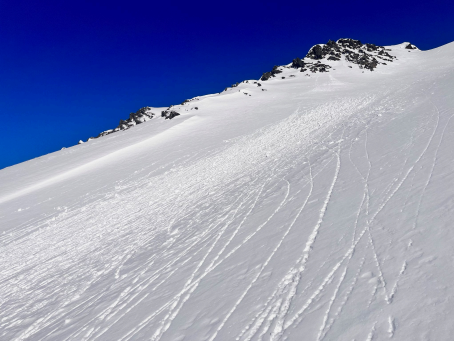
Debris from loose snow avalanches below just about every gulley in the Library yesterday. Similar activity is likely as warm temperatures continue today. Photo: Rachel Heath, 03.05.2023
As mentioned above, we are still keeping the weak layers of snow in the upper snowpack on our radar for now. For the most part, it seems these have become unreactive for most of our advisory area. The most concerning places where these weak layers may still be lingering are in the zones with a thinner snowpack. We’ve seen multiple observations pointing towards reactive weak layers towards the south end of Turnagain Pass and Summit Lake, and we suspect there may be similar structure towards Crow Pass. As the snowpack heats up today and tomorrow, it is worth keeping these layers in mind while you are choosing your terrain.
Yesterday: Winds were light out of the north at 5-10 mph with gusts from around 10-15 mph. Skies were mostly sunny, with some high clouds moving in during the afternoon. The coldest temperatures in the past 24 hours were yesterday morning, with temps in the single digits F in the valleys and in the low teens F at higher elevations. High temperatures made it up into the mid 20’s F at lower elevations and up into the mid 30’s F near ridgelines. As of 5:00 this morning, temperatures are in the mid teens to low 20’s F in the valleys and in the upper 20’s to low 30’s F at higher elevations. We did not receive any precipitation yesterday.
Today: The temperature inversion continues to build today, with high temperatures expected to reach the mid to upper 30’s F, and the warmest temperatures around 3000’-5000’ elevation. Winds should be light out of the northwest around 5 mph with gusts around 10 mph. Skies will be partly cloudy with some upper level clouds, and no precipitation is expected today.
Tomorrow: The inversion continues to build tonight into tomorrow. It is likely we will see temperatures stay above freezing tonight, with daytime highs tomorrow possibly getting into the 40’s F between 3000’-5000’. Skies should be mostly sunny with light westerly winds. No precipitation is expected tonight or tomorrow.
PRECIPITATION 24-hour data (6am – 6am)
Temp Avg (F) | Snow (in) | Water (in) | Snow Depth (in) | |
---|---|---|---|---|
Center Ridge (1880′) | 19 | 0 | 0 | 67 |
Summit Lake (1400′) | 15 | 0 | 0 | 38 |
Alyeska Mid (1700′) | 18 | 0 | 0 | 68 |
Bear Valley – Portage (132′) | 12 | 0 | 0 | – |
RIDGETOP 24-hour data (6am – 6am)
Temp Avg (F) | Wind Dir | Wind Avg (mph) | Wind Gust (mph) | |
---|---|---|---|---|
Sunburst (3812′) | 31 | W | 8 | 18 |
Seattle Ridge (2400′) | 27 | NNE | 2 | 7 |
Date | Region | Location | Observer |
---|---|---|---|
03/19/23 | Turnagain | Observation: Tin Can | Paul Schauer |
03/19/23 | Turnagain | Avalanche: Tincan | Megan Guinn |
03/18/23 | Turnagain | Observation: Turnagain Pass – valley bottoms | W Wagner |
03/17/23 | Turnagain | Observation: Tincan | Megan Guinn & John Sykes |
03/17/23 | Turnagain | Observation: Eddie’s/Summit | Alex Palombo |
03/16/23 | Turnagain | Observation: Twin Peaks Meadows | Schauer/ Pfeiffer Forecaster |
03/16/23 | Turnagain | Avalanche: Tincan | Elias Neuffer |
03/16/23 | Turnagain | Avalanche/People Involved: Tincan Trees | Anonymous |
03/16/23 | Turnagain | Avalanche/People Involved: Tincan Common | Catherine Rocchi |
03/15/23 | Turnagain | Observation: Tincan | John Sykes Forecaster |
Status of riding areas across the Chugach NF is managed by the Glacier and Seward Ranger Districts, not avalanche center staff. Riding area information is posted as a public service to our users and updated based on snow depth and snow density to prevent resource damage at trailhead locations. Riding area questions contact: mailroom_r10_chugach@fs.fed.us
Area | Status | Weather & Riding Conditions |
---|---|---|
Glacier District |
Subscribe to Turnagain Pass
Avalanche Forecast by Email
This is a general backcountry avalanche advisory issued for Turnagain Arm with Turnagain Pass as the core advisory area. This advisory does not apply to highways, railroads or operating ski areas.