Turnagain Pass RSS

Archives
ARCHIVED - Forecasts expire after 24 hours.
Issued
Tue, March 7th, 2023 - 7:00AM
Expires
Wed, March 8th, 2023 - 7:00AM
Forecaster
John Sykes
Avalanche risk The Bottom Line

The avalanche danger is MODERATE above 1000′. Unusually warm temperatures and sunny skies will make natural and human triggered wet loose avalanches likely, especially on southern slopes. These loose snow avalanche can build up steam on larger slopes and reach sizes large enough to bury a person. It is also possible that a loose snow avalanche could be enough to trigger a deeper avalanche on a buried weak layer. To identify areas of concern look for roller balls and small wet loose avalanches releasing naturally as an indicator that the surface conditions are deteriorating and it is time to move to a shadier aspect. Below 1000′ the avalanche danger is LOW.

Special Announcements

Turnagain Pass Avalanche Awareness Day – 2023: Mark your calendars for Saturday, March 18th, and swing by on your way to or from your backcountry ride or ski!! Test your beacon skills, chow down on hot dogs, and bring your questions. The Alaska Avalanche School will be there along with a chance to demo snowmachines from Alaska Mining and Diving Supply and Anchorage Yamaha and Polaris. More details HERE!

Tue, March 7th, 2023
Alpine
Above 2,500'
2 - Moderate
Avalanche risk
Treeline
1,000'-2,500'
2 - Moderate
Avalanche risk
Below Treeline
Below 1,000'
1 - Low
Avalanche risk
0 - No Rating
1 - Low
2 - Moderate
3 - Considerable
4 - High
5 - Extreme
Avalanche risk Avalanche risk Avalanche risk Avalanche risk Avalanche risk
Travel Advice Generally safe avalanche conditions. Watch for unstable snow on isolated terrain features. Heightened avalanche conditions on specific terrain features. Evaluate snow and terrain carefully; identify features of concern. Dangerous avalanche conditions. Careful snowpack evaluation, cautious route-finding, and conservative decision-making essential. Very dangerous avalanche conditions. Travel in avalanche terrain not recommended. Extraordinarily dangerous avalanche conditions. Avoid all avalanche terrain.
Likelihood of Avalanches Natural and human-triggered avalanches unlikely. Natural avalanches unlikely; human-triggered avalanches possible. Natural avalanches possible; human-triggered avalanches likely. Natural avalanches likely; human-triggered avalanches very likely. Natural and human-triggered avalanches certain.
Avalanche Size and Distribution Small avalanches in isolated areas or extreme terrain. Small avalanches in specific areas; or large avalanches in isolated areas. Small avalanches in many areas; or large avalanches in specific areas; or very large avalanches in isolated areas. Large avalanches in many areas; or very large avalanches in specific areas. Very large avalanches in many areas.
Recent Avalanches

The combination of warm temperatures and sunny skies yesterday were causing loose snow avalanches to release on steep southern aspects. Tincan Proper and the Library are perfect examples of terrain that receives strong solar warming where loose snow avalanches release from exposed rocks and then entrain more loose snow on the way down. These loose snow avalanches were increasing in size throughout the day yesterday with the largest being big enough to fully bury a person (D2).

Example of fresh loose snow avalanches occurring on steep south facing terrain and building up enough mass to be problematic for any parties in the area. Photo 3.6.23

Avalanche Problem 1
  • Wet Loose
    Wet Loose
  • Aspect/Elevation
  • Certain
    Very Likely
    Likely
    Possible
    Unlikely
    Likelihood
  • Historic (D4-5)
    Very Large (D3)
    Large (D2)
    Small (D1)
    Size
Wet Loose
Wet Loose avalanches are the release of wet unconsolidated snow or slush. These avalanches typically occur within layers of wet snow near the surface of the snowpack, but they may quickly gouge into lower snowpack layers. Like Loose Dry Avalanches, they start at a point and entrain snow as they move downhill, forming a fan-shaped avalanche. Other names for loose-wet avalanches include point-release avalanches or sluffs. Loose Wet avalanches can trigger slab avalanches that break into deeper snow layers.

Aspect/Elevation of the Avalanche Problem
Specialists develop a graphic representation of the potential distribution of a particular avalanche problem across the topography. This aspect/elevation rose is used to indicate where the particular avalanche problem is thought to exist on all elevation aspects. Areas where the avalanche problem is thought to exist are colored grey, and it is less likely to be encountered in areas colored white.

Likelihood of Avalanches
Terms such as "unlikely", "likely", and "certain" are used to define the scale, with the chance of triggering or observing avalanches increasing as we move up the scale. For our purposes, "Unlikely" means that few avalanches could be triggered in avalanche terrain and natural avalanches are not expected. "Certain" means that humans will be able to trigger avalanches on many slopes, and natural avalanches are expected.

Size of Avalanches
Avalanche size is defined by the largest potential avalanche, or expected range of sizes related to the problem in question. Assigned size is a qualitative estimate based on the destructive classification system and requires specialists to estimate the harm avalanches may cause to hypothetical objects located in the avalanche track (AAA 2016, CAA 2014). Under this schema, "Small" avalanches are not large enough to bury humans and are relatively harmless unless they carry people over cliffs or through trees or rocks. Moving up the scale, avalanches become "Large" enough to bury, injure, or kill people. "Very Large" avalanches may bury or destroy vehicles or houses, and "Historic" avalanches are massive events capable of altering the landscape.

Signal Word Size (D scale) Simple Descriptor
Small 1 Unlikely to bury a person
Large 2 Can bury a person
Very Large 3 Can destroy a house
Historic 4 & 5 Can destroy part or all of a village
More info at Avalanche.org

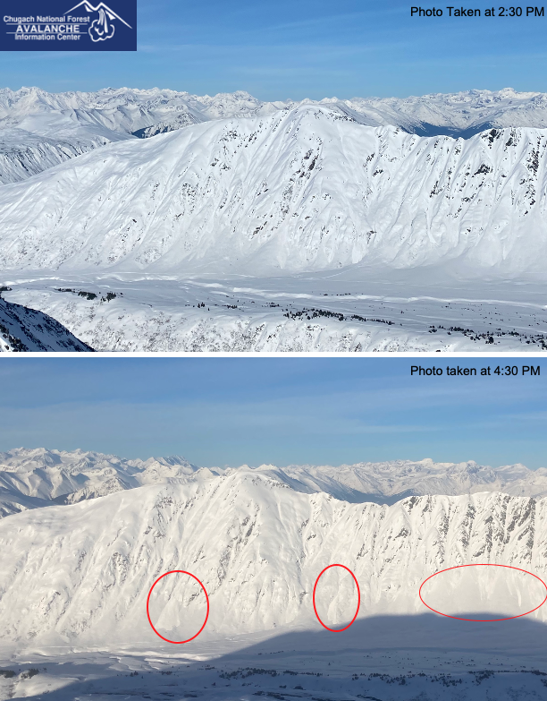
It was eerily warm in the mountains last night, with the full moon lighting up the slopes and temperatures hovering around 35 F at upper elevations. Today we are expecting conditions to be very similar to yesterday. Except the temperature inversion is expected to be even stronger, potentially reaching 40-45 F between 3500-4500′. Despite the warm temperatures, the clear skies overnight probably allowed the snow surface to re-freeze after the surface melting yesterday. Wet loose avalanches releasing near rocks or trees and entraining loose snow below should increase in size throughout the day as the surface snow softens. These could become large enough to bury a person later in the day and are likely to be releasing naturally on steep southerly slopes receiving direct sun. Human triggered wet loose avalanches are also likely and it is helpful to have a plan to manage them by carefully choosing your terrain. Due to the unusually warm temperatures human triggered wet loose avalanches or roller balls are also possible on aspects that are not receiving direct sunshine.

To manage this avalanche problem it is important to monitor the snow surface conditions on a variety of aspects and be aware of any steep south facing slopes above you that could be heating up quickly. Wet loose avalanches can run a surprising distance down slope and if they pick up enough loose snow on the way down they can pack a serious punch. Typically you can switch to a shadier aspect to avoid wet loose avalanches, but with the unusually warm temperatures today it is possible that wet loose avalanches or roller balls could occur even on shady slopes.

Cornice fall is more likely with warm temperatures and strong sunshine, so it is important to be aware of any cornices overhead and try to give them a wide berth if you are travelling along a ridgeline. A big chunk of cornice falling also has the potential to trigger a slab avalanche on the slope below.

Glide cracks have been opening up over the past several weeks and the rapid change in temperature could make them more likely to release. These things have a mind of their own and can really release under any conditions, so it is important to be aware of any glide cracks overhead and try to minimize time spent underneath them.

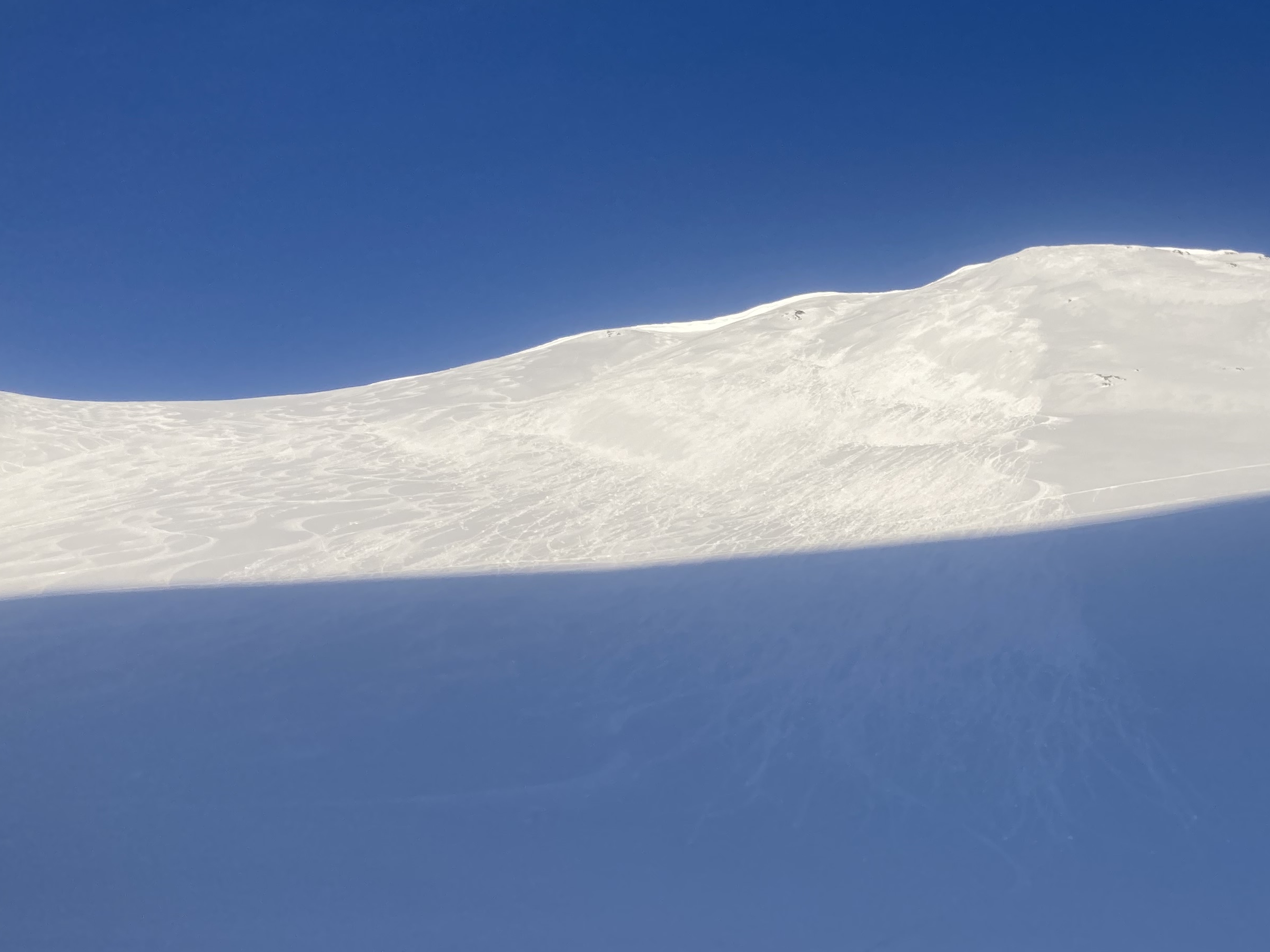
Fresh roller balls are a strong sign that the snow surface is heating up and wet loose avalanches are possible. Photo 3.6.23

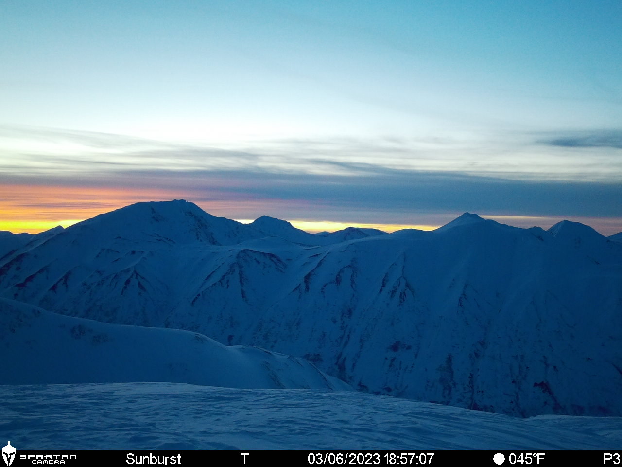
Andrew and Megan re-installed the Sunburst webcam yesterday just in time to catch the sunset! We will get the images back up on the Sunburst weather page ASAP. Photo 3.6.23

Additional Concern
  • Persistent Slabs
    Persistent Slabs
Persistent Slabs
Persistent Slab avalanches are the release of a cohesive layer of snow (a slab) in the middle to upper snowpack, when the bond to an underlying persistent weak layer breaks. Persistent layers include: surface hoar, depth hoar, near-surface facets, or faceted snow. Persistent weak layers can continue to produce avalanches for days, weeks or even months, making them especially dangerous and tricky. As additional snow and wind events build a thicker slab on top of the persistent weak layer, this avalanche problem may develop into a Deep Persistent Slab.
More info at Avalanche.org

The rapid warming of the snowpack over the past few days could be enough to cause an avalanche on a buried weak layer or an old lingering wind slab. We have several weak layers in the upper 2-3′ of the snowpack the have been unreactive for several weeks now, but it is feasible that the rapid warming or a loose snow avalanche on the surface could trigger a deeper avalanche in an isolated area. These weak layers are more prominent in areas of the forecast zone that have a thinner snowpack, like near Crow Pass and Johnson Pass Trailhead, so extra caution is recommended if you are travelling in one of those areas.

Weather
Tue, March 7th, 2023

Yesterday: Sunny skies with a strong temperature inversion leading to warmer temperatures at upper elevations. Ridgetop weather stations are reporting temperatures of 30-35 F throughout the last 24 hours. Weather stations below 2000′ elevation saw somewhat colder temps over the past 24 hours ranging from the teens overnight to 40 F during the heat of the day. Winds have been averaging 0-10 mph over the past 24 hours with gusts up to 15 mph.

Today: Sunny skies and warm temperatures will continue today, with temperature possibly reaching 40-45 F from 3500 to 4500′! At lower elevations the temperatures should be slightly lower but still expected to remain above freezing. Valley bottoms could have cold air pooling into them, causing winds along Turnagain Arm. Wind speeds should be 0-10 mph with gusts to 15 mph. Today should be the warmest day of this high pressure temperature inversion.

Tomorrow: Wednesday looks like the last day of this stable and warm weather pattern. Conditions will be very similar to today with some high clouds possible but otherwise sunny and warm. Wednesday night winds are expected to shift to NW and increase slightly to 5-15 mph. These increased winds will move the temperature inversion out of the area overnight Wednesday and return us to more normal seasonal temperatures.

PRECIPITATION 24-hour data (6am – 6am)

Temp Avg (F) Snow (in) Water (in) Snow Depth (in)
Center Ridge (1880′) 32 0 0 66
Summit Lake (1400′) 23 0 0 38
Alyeska Mid (1700′) 29 0 0 68
Bear Valley – Portage (132′) 17 0 0

RIDGETOP 24-hour data (6am – 6am)

Temp Avg (F) Wind Dir Wind Avg (mph) Wind Gust (mph)
Sunburst (3812′) 34 W 7 17
Seattle Ridge (2400′) 34 NE 2 9
Observations
Recent Observations for Turnagain Pass
Date Region Location
04/16/24 Turnagain Observation: Cornbiscuit
04/15/24 Turnagain Observation: Taylor Pass
04/15/24 Turnagain Observation: Seward Highway – Tern Lake to Portage
04/14/24 Turnagain Observation: Sunburst
04/14/24 Turnagain Observation: Turnagain Pass Snomo
04/13/24 Turnagain Observation: Spokane Creek
04/11/24 Turnagain Observation: Tincan
04/10/24 Turnagain Avalanche: Seattle Ridge
04/10/24 Turnagain Observation: Cornbiscuit South Face
04/10/24 Turnagain Avalanche: Tincan
Riding Areas

The riding areas page has moved. Please click here & update your bookmarks.


Subscribe to Turnagain Pass
Avalanche Forecast by Email

This is a general backcountry avalanche advisory issued for Turnagain Arm with Turnagain Pass as the core advisory area. This advisory does not apply to highways, railroads or operating ski areas.