Turnagain Pass RSS

Archives
ARCHIVED - Forecasts expire after 24 hours.
Issued
Fri, March 6th, 2020 - 7:00AM
Expires
Sat, March 7th, 2020 - 7:00AM
Forecaster
Aleph Johnston-Bloom
Avalanche risk The Bottom Line

The avalanche danger is MODERATE today. Triggering a wind slab avalanche around a foot deep will be still possible on slopes that were loaded by the recent outflow (west/northwest wind) event. Additionally, triggering a very large avalanche breaking in weak snow 3-6 feet deep remains a concern region-wide. Avoid travel on or underneath cornices, watch your sluff in steep protected terrain and pay attention to solar heating.

SUMMIT LAKE TO SEWARD REGION:  The outflow winds impacted Summit Lake to Lost Lake, significant wind loading and natural avalanches were observed. Triggering a wind slab will still be possible today. Continued caution is advised on wind affected slopes.

Special Announcements

Heading to Hatcher Pass or Chugach State Park? Please check out the recent avalanche observations. Don’t forget to check the Hatcher Pass Avalanche Center Saturday forecast tomorrow! Thanks to everyone sending in information this week region-wide.

Fri, March 6th, 2020
Alpine
Above 2,500'
2 - Moderate
Avalanche risk
Treeline
1,000'-2,500'
2 - Moderate
Avalanche risk
Below Treeline
Below 1,000'
2 - Moderate
Avalanche risk
0 - No Rating
1 - Low
2 - Moderate
3 - Considerable
4 - High
5 - Extreme
Avalanche risk Avalanche risk Avalanche risk Avalanche risk Avalanche risk
Travel Advice Generally safe avalanche conditions. Watch for unstable snow on isolated terrain features. Heightened avalanche conditions on specific terrain features. Evaluate snow and terrain carefully; identify features of concern. Dangerous avalanche conditions. Careful snowpack evaluation, cautious route-finding, and conservative decision-making essential. Very dangerous avalanche conditions. Travel in avalanche terrain not recommended. Extraordinarily dangerous avalanche conditions. Avoid all avalanche terrain.
Likelihood of Avalanches Natural and human-triggered avalanches unlikely. Natural avalanches unlikely; human-triggered avalanches possible. Natural avalanches possible; human-triggered avalanches likely. Natural avalanches likely; human-triggered avalanches very likely. Natural and human-triggered avalanches certain.
Avalanche Size and Distribution Small avalanches in isolated areas or extreme terrain. Small avalanches in specific areas; or large avalanches in isolated areas. Small avalanches in many areas; or large avalanches in specific areas; or very large avalanches in isolated areas. Large avalanches in many areas; or very large avalanches in specific areas. Very large avalanches in many areas.
Recent Avalanches

Yesterday there was a very large snowmachine triggered avalanche in Lynx Creek. Both riders were on the slope when it slid but were not buried. The slope that avalanched was on an aspect loaded by the outflow winds and potentially stepped down to the January facets.

Lynx snowmachine triggered avalanche observed from above. 3.5.20. Photo: Paul Forward

Lynx snowmachine triggered avalanche. Thanks to the party involved for sharing images and information. 3.5.20.

Avalanche Problem 1
  • Wind Slabs
    Wind Slabs
  • Certain
    Very Likely
    Likely
    Possible
    Unlikely
    Likelihood
  • Historic (D4-5)
    Very Large (D3)
    Large (D2)
    Small (D1)
    Size
Wind Slabs
Wind Slab avalanches are the release of a cohesive layer of snow (a slab) formed by the wind. Wind typically transports snow from the upwind sides of terrain features and deposits snow on the downwind side. Wind slabs are often smooth and rounded and sometimes sound hollow, and can range from soft to hard. Wind slabs that form over a persistent weak layer (surface hoar, depth hoar, or near-surface facets) may be termed Persistent Slabs or may develop into Persistent Slabs.

Likelihood of Avalanches
Terms such as "unlikely", "likely", and "certain" are used to define the scale, with the chance of triggering or observing avalanches increasing as we move up the scale. For our purposes, "Unlikely" means that few avalanches could be triggered in avalanche terrain and natural avalanches are not expected. "Certain" means that humans will be able to trigger avalanches on many slopes, and natural avalanches are expected.

Size of Avalanches
Avalanche size is defined by the largest potential avalanche, or expected range of sizes related to the problem in question. Assigned size is a qualitative estimate based on the destructive classification system and requires specialists to estimate the harm avalanches may cause to hypothetical objects located in the avalanche track (AAA 2016, CAA 2014). Under this schema, "Small" avalanches are not large enough to bury humans and are relatively harmless unless they carry people over cliffs or through trees or rocks. Moving up the scale, avalanches become "Large" enough to bury, injure, or kill people. "Very Large" avalanches may bury or destroy vehicles or houses, and "Historic" avalanches are massive events capable of altering the landscape.

Signal Word Size (D scale) Simple Descriptor
Small 1 Unlikely to bury a person
Large 2 Can bury a person
Very Large 3 Can destroy a house
Historic 4 & 5 Can destroy part or all of a village
More info at Avalanche.org

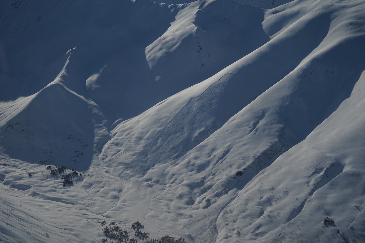
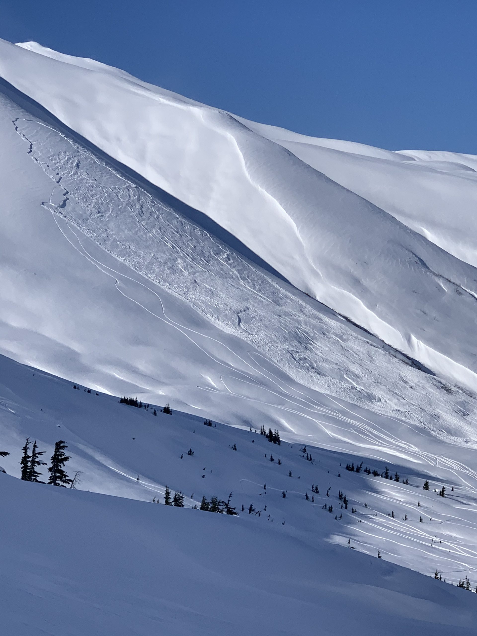
The outflow winds (west/northwest) continued yesterday, finally easing off in the late afternoon. Today determining whether or not the slope you are traveling on was wind affected will be the key to avoiding most of the current avalanche issues. Wind slabs remain possible in wind loaded terrain. The snowmachine triggered avalanche in Lynx Creek, that is highlighted above in recent avalanches, occurred on a slope that was being actively loaded yesterday and the day before. This looks to have potentially been initiated failing below the wind loaded layer and then stepping down deeper to older buried weak snow (more below in Avalanche Problem 2). Another part of the equation is that underneath the wind affected snow there could be buried surface hoar making the wind slabs easier to trigger and possibly propagate further above or to the side than expected. There were a couple small skier triggered avalanches in upper Girdwood Valley yesterday including one remote trigger that were believed to have failed on this layer around a foot deep. Be on the lookout for stiff snow over softer snow, shooting cracks and drifting patterns near ridgelines and in gullies where the snow looks pillowed or fat. Much of the core Turnagain Pass area seems to have been spared but as soon as you get to either end of the pass the wind effect is fairly obvious. Summit Lake, which is out of the forecast area, was harder hit by the outflow winds and there was a natural wind initiated avalanche cycle over the past couple days.

Cornices:  Avoid travel on or underneath cornices.

Loose snow avalanches:  In areas that were protected from the wind, sluffs are possible in steep terrain.

Sun effect:  With calm winds and temperatures increasing today look for signs of sun effect on steep solar aspects: moist surface snow, small roller balls or loose snow avalanches in protected spots, especially below rocky areas.  Slopes that are also wind loaded may be more prone to triggering if they heat up enough.

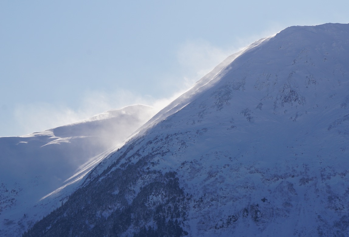
Wind transport in the early afternoon on the northeast corner of Pyramid Peak yesterday. 3.5.20

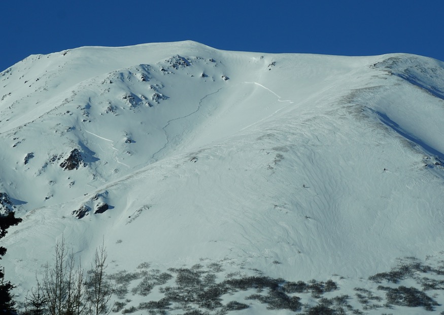
Wind triggered avalanche that occurred yesterday on Summit Peak in Summit Lake yesterday. Note the wind effect on the slopes and scoured ridges. 3.5.20. 

Avalanche Problem 2
  • Deep Persistent Slabs
    Deep Persistent Slabs
  • Certain
    Very Likely
    Likely
    Possible
    Unlikely
    Likelihood
  • Historic (D4-5)
    Very Large (D3)
    Large (D2)
    Small (D1)
    Size
Deep Persistent Slabs
Deep Persistent Slab avalanches are the release of a thick cohesive layer of hard snow (a slab), when the bond breaks between the slab and an underlying persistent weak layer deep in the snowpack. The most common persistent weak layers involved in deep, persistent slabs are depth hoar or facets surrounding a deeply buried crust. Deep Persistent Slabs are typically hard to trigger, are very destructive and dangerous due to the large mass of snow involved, and can persist for months once developed. They are often triggered from areas where the snow is shallow and weak, and are particularly difficult to forecast for and manage.

Likelihood of Avalanches
Terms such as "unlikely", "likely", and "certain" are used to define the scale, with the chance of triggering or observing avalanches increasing as we move up the scale. For our purposes, "Unlikely" means that few avalanches could be triggered in avalanche terrain and natural avalanches are not expected. "Certain" means that humans will be able to trigger avalanches on many slopes, and natural avalanches are expected.

Size of Avalanches
Avalanche size is defined by the largest potential avalanche, or expected range of sizes related to the problem in question. Assigned size is a qualitative estimate based on the destructive classification system and requires specialists to estimate the harm avalanches may cause to hypothetical objects located in the avalanche track (AAA 2016, CAA 2014). Under this schema, "Small" avalanches are not large enough to bury humans and are relatively harmless unless they carry people over cliffs or through trees or rocks. Moving up the scale, avalanches become "Large" enough to bury, injure, or kill people. "Very Large" avalanches may bury or destroy vehicles or houses, and "Historic" avalanches are massive events capable of altering the landscape.

Signal Word Size (D scale) Simple Descriptor
Small 1 Unlikely to bury a person
Large 2 Can bury a person
Very Large 3 Can destroy a house
Historic 4 & 5 Can destroy part or all of a village
More info at Avalanche.org

The avalanche that occurred in Lynx Creek looks to have possibly stepped down to the older faceted January snow. This hasn’t been confirmed. However, it’s not a bad idea to keep this on your radar as you choose terrain today. Triggering an avalanche in the upper snowpack could initiate an avalanche that breaks down lower. As we keep saying those buried facets are a lingering concern, a nagging what if.  These layers are buried between 3-6 feet deep. Overall as time has gone by, the likelihood of triggering has been decreasing but today has a couple factors that could swing that the other way.  Terrain that was just wind loaded could be a bit more stressed and prone to triggering and slopes that get direct solar effect as temperatures increase could also be more suspect.  In areas outside our forecast zone to the south, with a shallower snowpack, you are more likely to find one of these large slabs. Don’t forget to use good travel protocol and consider consequences when choosing terrain.

Snowmachine triggered avalanche in Lynx Creek yesterday. Check out the spots where the avalanche potentially stepped down to older layers in the snowpack. 3.6.20.

Weather
Fri, March 6th, 2020

Yesterday: Skies were mostly clear with temperatures in the single digits to low 20°Fs. Winds were westerly 5-15 mph with gusts into the 20s. Overnight a temperature inversion set up with valley bottoms below zero and upper elevations in the single digits to low teens. Winds were light and shifted to the east.

Today: Mostly sunny skies with temperatures in the high teens to mid 20°Fs. Winds will be easterly 5-15 mph with gusts into the 20s. Clouds will build overnight with a chance of snow showers. Temperatures will be in the single digits and winds will be easterly 5-10 mph.

Tomorrow: Mostly cloudy skies with temperatures in the 20°Fs and with snow showers in the afternoon. Winds will remain easterly 5-10 mph. Snow showers continue overnight with temperatures in the teens and east winds increasing with gusts in the 30s. Light snow looks to continue through Sunday and maybe into early next week.

PRECIPITATION 24-hour data (6am – 6am)

Temp Avg (F) Snow (in) Water (in) Snow Depth (in)
Center Ridge (1880′) 7 0 0 72
Summit Lake (1400′) 2 0 0 32
Alyeska Mid (1700′) 8 0 0 81

RIDGETOP 24-hour data (6am – 6am)

Temp Avg (F) Wind Dir Wind Avg (mph) Wind Gust (mph)
Sunburst (3812′) 4 W 7 23
Seattle Ridge (2400′) 5 W 4 12
Observations
Recent Observations for Turnagain Pass
Date Region Location
04/16/24 Turnagain Observation: Cornbiscuit
04/15/24 Turnagain Observation: Taylor Pass
04/15/24 Turnagain Observation: Seward Highway – Tern Lake to Portage
04/14/24 Turnagain Observation: Sunburst
04/14/24 Turnagain Observation: Turnagain Pass Snomo
04/13/24 Turnagain Observation: Spokane Creek
04/11/24 Turnagain Observation: Tincan
04/10/24 Turnagain Avalanche: Seattle Ridge
04/10/24 Turnagain Observation: Cornbiscuit South Face
04/10/24 Turnagain Avalanche: Tincan
Riding Areas

The riding areas page has moved. Please click here & update your bookmarks.


Subscribe to Turnagain Pass
Avalanche Forecast by Email

This is a general backcountry avalanche advisory issued for Turnagain Arm with Turnagain Pass as the core advisory area. This advisory does not apply to highways, railroads or operating ski areas.