Turnagain Pass Avalanche Forecast
|
![]() ![]() |
The avalanche danger remains MODERATE today. Northwest outflow winds will continue to impact the region. Watch for winds actively moving snow and wind effect on the snow surface. Wind slab avalanches around a foot thick will be possible to trigger on freshly loaded slopes. Additionally, triggering a very large avalanche breaking in weak snow 3-6 feet deep remains a concern region-wide.
SUMMIT LAKE TO SEWARD REGION: Winds are will continue to be strong in this area and a CONSIDERABLE danger applies again today. Check Seward and Summit Lake observations from yesterday. Natural wind slabs are possible and human triggered slabs are likely. Watch for blowing snow and loading slopes. Extra caution is advised.
Heading to Hatcher Pass or Chugach State Park? Check out the recent observations before you go.
Where and how are Alaskans traveling in the backcountry? Please consider taking this short survey. It only takes 5 minutes! Help the avalanche and snow science community investigate who, how and where Alaskans travel in the backcountry. Project led by University of Alaska Southeast.
Signal Word | Size (D scale) | Simple Descriptor |
Small | 1 | Unlikely to bury a person |
Large | 2 | Can bury a person |
Very Large | 3 | Can destroy a house |
Historic | 4 & 5 | Can destroy part or all of a village |
Heading out today to enjoy some sunshine? The outflow winds are forecast to continue through the day. Paying attention to what the wind is doing and has done in the terrain you are traveling will be crucial. Observing the outflow winds (west/northwest) in the forecast area yesterday was pretty interesting and as often the case with this wind pattern, the impact was not straightforward. Pluming was observed in the mountains around Girdwood but there was not much wind at Alyeska. Winds were channeled through the Arm and into Placer Valley but wind speeds were light at the Seattle Ridge weather station. Sunburst weather station reported mostly light northwest winds but observers on Sunburst felt the wind coming through the Pass from the south. Looking at the south end of Seattle Ridge, near the Johnson Pass north trail head, the pluming was obvious. A natural wind slab was observed in motion near the Hope Y mid-day. From there south to Lost Lake the wind transport was notable. As Wendy mentioned yesterday many of our ridgetop weather stations don’t pick up the northwest flow direction very well. AKRR MP 43 weather station that sits near Bench Peak, above and to the west of Grandview, does seem to capture these winds. Steady winds in the 20s with gusts into the 40s were recorded in the late afternoon and overnight.
Wind Slabs: Other than witnessing active wind loading and slabs developing while you are on slope, pay attention to surface conditions indicating previous wind loading. Be on the lookout for stiff snow over softer snow, shooting cracks and drifting patterns near ridgelines and in gullies. Also keep in mind that a layer of buried surface hoar may be sitting under wind slabs, making them easier to trigger and possibly propagate further above or to the side than expected.
Wind on peak 4,940 (South end of Seattle Ridge across from Johnson Pass north TH ) at 4:30pm. 3.4.20. Photo: Nick D’Alessio
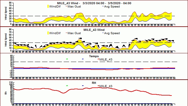
Cornices: Small fresh cornice falls from winds today are possible in areas seeing significant wind. Most likely outside of the forecast zone.
Loose snow avalanches: In areas out of the wind, sluffs are possible in steep terrain.
Sun effect: The wind and cold temperatures should overrule any sun effect today.
Signal Word | Size (D scale) | Simple Descriptor |
Small | 1 | Unlikely to bury a person |
Large | 2 | Can bury a person |
Very Large | 3 | Can destroy a house |
Historic | 4 & 5 | Can destroy part or all of a village |
You might ask yourself, “Why are they still talking about the January facets in March?” Unfortunately that is the nature of a deep persistent issue. Those facets are a lingering concern, a nagging what if. These layers are buried between 3-6 feet deep and there is still a chance of a person could trigger a very large and dangerous avalanche. As time goes by, the likelihood of triggering is decreasing but we haven’t completely it ruled out. In areas outside our forecast zone to the south, with a shallower snowpack, you are more likely to find one of these large slabs. Also, areas with little traffic this season are more suspect. Don’t forget to use good travel protocol and consider consequences when choosing terrain.
Yesterday: Skies were mostly clear and temperatures ranged from the single digits above 0°F to single digits below 0°F. Winds were westerly 5-15 mph with gusts into the 20s in areas sheltered from the outflow. In areas more impacted by this wind pattern winds were westerly 15-25 mph with gusts into the 40s. Overnight temperatures rose just slightly and outflow winds continued to be gusty.
Today: Skies will be clear today with temperatures in the single digits to low teens. The outflow winds are forecast to continue today 10-20 mph with gusts into 30s and ease off this evening. Look for the westerly winds to be more pronounced through Turnagain Arm and south of Turnagain Pass. Tonight will be mostly clear with temperatures around or just below 0°F.
Tomorrow: Increasing clouds, temperatures in the teens and low 20°Fs and light east winds. Skies will be mostly cloudy overnight with a chance of snow showers. There is snow in the forecast for the weekend but the timing and details are still uncertain. Stay tuned!
PRECIPITATION 24-hour data (6am – 6am)
Temp Avg (F) | Snow (in) | Water (in) | Snow Depth (in) | |
---|---|---|---|---|
Center Ridge (1880′) | 5 | 0 | 0 | 73 |
Summit Lake (1400′) | 4 | 0 | 0 | 32 |
Alyeska Mid (1700′) | 3 | 0 | 0 | 83 |
RIDGETOP 24-hour data (6am – 6am)
Temp Avg (F) | Wind Dir | Wind Avg (mph) | Wind Gust (mph) | |
---|---|---|---|---|
Sunburst (3812′) | -5 | WNW | 8 | 24 |
Seattle Ridge (2400′) | -1 | W | 4 | 17 |
Date | Region | Location | Observer |
---|---|---|---|
05/22/23 | Turnagain | Avalanche: Tincan | Nick D'Alessio |
05/12/23 | Turnagain | Avalanche: Tincan, Sunburst, Magnum, Cornbiscuit | Heather Thamm |
05/07/23 | Turnagain | Observation: Tincan – Bear Tracks | CNFAIC Staff |
05/05/23 | Turnagain | Observation: Seattle Ridge | AS/ WW Forecaster |
05/02/23 | Turnagain | Observation: Cornbiscuit | Schauer/ Sturgess Forecaster |
05/02/23 | Turnagain | Observation: Seward Hwy Turnagain Pass | Joel Curtis |
04/30/23 | Turnagain | Observation: Magnum | Ayla, Kit Crosby, Barton |
04/29/23 | Turnagain | Observation: Tincan | John Sykes |
04/28/23 | Turnagain | Avalanche: Taylor Pass/Pastoral | Schauer/ Creighton Forecaster |
04/28/23 | Turnagain | Avalanche: Tincan | Andy Moderow |
Status of riding areas across the Chugach NF is managed by the Glacier and Seward Ranger Districts, not avalanche center staff. Riding area information is posted as a public service to our users and updated based on snow depth and snow density to prevent resource damage at trailhead locations. Riding area questions contact: mailroom_r10_chugach@fs.fed.us
Area | Status | Weather & Riding Conditions |
---|---|---|
Glacier District |
Subscribe to Turnagain Pass
Avalanche Forecast by Email
This is a general backcountry avalanche advisory issued for Turnagain Arm with Turnagain Pass as the core advisory area. This advisory does not apply to highways, railroads or operating ski areas.