Turnagain Pass RSS

Archives
ARCHIVED - Forecasts expire after 24 hours.
Issued
Sat, March 4th, 2023 - 7:00AM
Expires
Sun, March 5th, 2023 - 7:00AM
Forecaster
John Sykes
Avalanche risk The Bottom Line

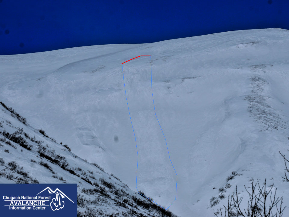
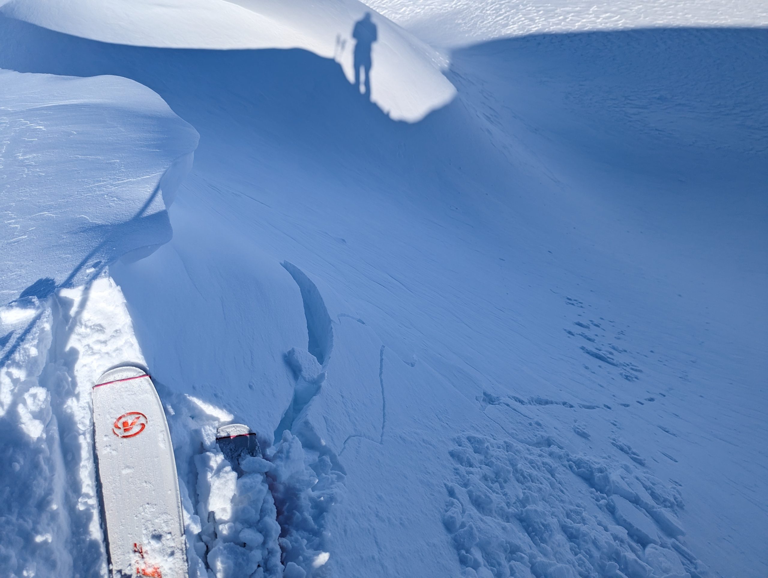
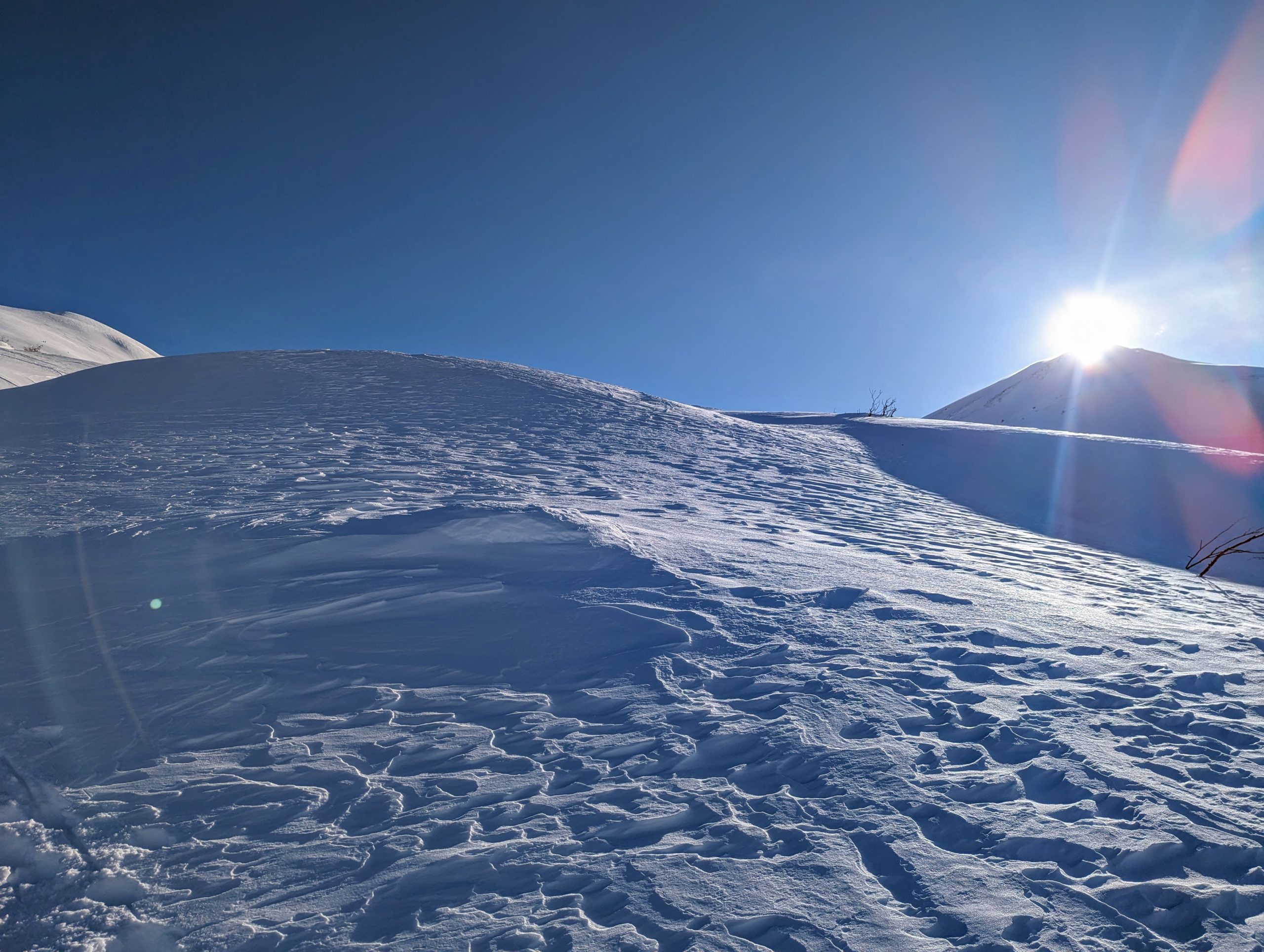
The avalanche danger is CONSIDERABLE above 2500′. Continued NW outflow winds are making natural wind slabs up to 1′ deep possible and human triggered avalanches likely in areas with active wind loading. These winds tend to favor areas along Turnagain Arm and other places where gaps winds are common. In areas sheltered from the recent winds the likelihood of avalanches is lower. Throughout the day the winds are expected decrease which should lead to decreasing likelihood of natural avalanches.

From 1000′ to 2500′ the avalanche danger is MODERATE. Overall, these elevations were less exposed to the recent winds. However, it is still important to identify and assess areas that could have been recently wind loaded. Below 1000′ the avalanche danger is LOW. 

SUMMIT LAKE / LOST LAKE / SNUG HARBOR: Strong NW outflow winds impacted these areas over the past few days and wind slabs are likely for human triggering. In areas with a thinner snowpack, like Summit Lake, the recent wind loading could be enough to make buried weak layer more sensitive today. Careful snowpack evaluation is recommended before entering avalanche terrain.

Special Announcements

Turnagain Pass Avalanche Awareness Day – Mar 18, 2023:  Mark your calendars and swing by on your way to or from your backcountry ride or ski!! Test your beacon skills, chow down on hot dogs, and bring your questions for CNFAC forecasters. The Alaska Avalanche School will be there along with a chance to demo snowmachines from Alaska Mining and Diving Supply and Anchorage Yamaha and Polaris. More details HERE!

Sat, March 4th, 2023
Alpine
Above 2,500'
3 - Considerable
Avalanche risk
Treeline
1,000'-2,500'
2 - Moderate
Avalanche risk
Below Treeline
Below 1,000'
1 - Low
Avalanche risk
0 - No Rating
1 - Low
2 - Moderate
3 - Considerable
4 - High
5 - Extreme
Avalanche risk Avalanche risk Avalanche risk Avalanche risk Avalanche risk
Travel Advice Generally safe avalanche conditions. Watch for unstable snow on isolated terrain features. Heightened avalanche conditions on specific terrain features. Evaluate snow and terrain carefully; identify features of concern. Dangerous avalanche conditions. Careful snowpack evaluation, cautious route-finding, and conservative decision-making essential. Very dangerous avalanche conditions. Travel in avalanche terrain not recommended. Extraordinarily dangerous avalanche conditions. Avoid all avalanche terrain.
Likelihood of Avalanches Natural and human-triggered avalanches unlikely. Natural avalanches unlikely; human-triggered avalanches possible. Natural avalanches possible; human-triggered avalanches likely. Natural avalanches likely; human-triggered avalanches very likely. Natural and human-triggered avalanches certain.
Avalanche Size and Distribution Small avalanches in isolated areas or extreme terrain. Small avalanches in specific areas; or large avalanches in isolated areas. Small avalanches in many areas; or large avalanches in specific areas; or very large avalanches in isolated areas. Large avalanches in many areas; or very large avalanches in specific areas. Very large avalanches in many areas.
Recent Avalanches

There were several fresh piles of avalanche debris along the base of the SW face of Seattle Ridge yesterday but the crowns had already been filled in by wind transport so it is hard to say exactly how old those avalanches are. Our best guess is that they were triggered naturally by wind loading within the last 2 days. A group digging snow pits in the lower Tincan meadows observed an avalanche in motion in Todd’s run on the N aspect of Tincan at about 3500′ (see ob here). They could not tell whether it was a dry loose or wind slab from their vantage point, but based on the location they suspected it was a small wind slab which released naturally.

Example of debris on SE aspect of Seattle Ridge with a possible crown on the upper shoulder above the gully feature. Photo 3.3.23

Avalanche Problem 1
  • Wind Slabs
    Wind Slabs
  • Aspect/Elevation
  • Certain
    Very Likely
    Likely
    Possible
    Unlikely
    Likelihood
  • Historic (D4-5)
    Very Large (D3)
    Large (D2)
    Small (D1)
    Size
Wind Slabs
Wind Slab avalanches are the release of a cohesive layer of snow (a slab) formed by the wind. Wind typically transports snow from the upwind sides of terrain features and deposits snow on the downwind side. Wind slabs are often smooth and rounded and sometimes sound hollow, and can range from soft to hard. Wind slabs that form over a persistent weak layer (surface hoar, depth hoar, or near-surface facets) may be termed Persistent Slabs or may develop into Persistent Slabs.

Aspect/Elevation of the Avalanche Problem
Specialists develop a graphic representation of the potential distribution of a particular avalanche problem across the topography. This aspect/elevation rose is used to indicate where the particular avalanche problem is thought to exist on all elevation aspects. Areas where the avalanche problem is thought to exist are colored grey, and it is less likely to be encountered in areas colored white.

Likelihood of Avalanches
Terms such as "unlikely", "likely", and "certain" are used to define the scale, with the chance of triggering or observing avalanches increasing as we move up the scale. For our purposes, "Unlikely" means that few avalanches could be triggered in avalanche terrain and natural avalanches are not expected. "Certain" means that humans will be able to trigger avalanches on many slopes, and natural avalanches are expected.

Size of Avalanches
Avalanche size is defined by the largest potential avalanche, or expected range of sizes related to the problem in question. Assigned size is a qualitative estimate based on the destructive classification system and requires specialists to estimate the harm avalanches may cause to hypothetical objects located in the avalanche track (AAA 2016, CAA 2014). Under this schema, "Small" avalanches are not large enough to bury humans and are relatively harmless unless they carry people over cliffs or through trees or rocks. Moving up the scale, avalanches become "Large" enough to bury, injure, or kill people. "Very Large" avalanches may bury or destroy vehicles or houses, and "Historic" avalanches are massive events capable of altering the landscape.

Signal Word Size (D scale) Simple Descriptor
Small 1 Unlikely to bury a person
Large 2 Can bury a person
Very Large 3 Can destroy a house
Historic 4 & 5 Can destroy part or all of a village
More info at Avalanche.org

The good news is that even after several days of NW outflow winds there is still soft snow to be found in Turnagain Pass. However, there are a lot of areas along ridgelines and more prominent features where the soft surface snow has been blown into firmer wind affected surfaces which could potentially be harboring wind slabs on leeward slopes. We found a few small test slopes that were producing shooting cracks yesterday but they were pretty stubborn to release under the weight of a skier. In areas where there has been more recent wind loading, like along upper elevation ridges and cross loaded gullies, these wind slabs could be more reactive to human triggers and human triggered avalanches 1’+ deep are likely. In areas experiencing active wind loading today natural avalanches are also possible.

The NW outflow winds that have been impacting the forecast area over the past several days are expected to decrease today. Overnight the wind speeds continued to average 10-20 mph with gusts to 30-40 mph, with the strongest winds in areas exposed to Turnagain Arm and other favored locations for gaps winds. Today the winds speeds are expected to decrease to 5-15 mph with gusts to 25 mph around mid day. This should decrease the chances of natural and human triggered avalanches in the second half of the day, but it will still be possible to find a lingering wind slab.

In areas protected from the winds dry loose avalanches (aka sluffs) are likely in steeper terrain. In addition all the recent winds combined with sun could make cornices more likely to fail today. Keep an eye out for cornices that are being actively wind loaded and receiving direct sunlight today.

Shooting crack on a cross loaded gully around 2000′ on Sunburst yesterday. Photo 3.3.23

Surface conditions ranged from firm to soft even in areas with visible wind texture on the surface yesterday. Photo 3.3.23

Avalanche Problem 2
  • Persistent Slabs
    Persistent Slabs
  • Aspect/Elevation
  • Certain
    Very Likely
    Likely
    Possible
    Unlikely
    Likelihood
  • Historic (D4-5)
    Very Large (D3)
    Large (D2)
    Small (D1)
    Size
Persistent Slabs
Persistent Slab avalanches are the release of a cohesive layer of snow (a slab) in the middle to upper snowpack, when the bond to an underlying persistent weak layer breaks. Persistent layers include: surface hoar, depth hoar, near-surface facets, or faceted snow. Persistent weak layers can continue to produce avalanches for days, weeks or even months, making them especially dangerous and tricky. As additional snow and wind events build a thicker slab on top of the persistent weak layer, this avalanche problem may develop into a Deep Persistent Slab.

Aspect/Elevation of the Avalanche Problem
Specialists develop a graphic representation of the potential distribution of a particular avalanche problem across the topography. This aspect/elevation rose is used to indicate where the particular avalanche problem is thought to exist on all elevation aspects. Areas where the avalanche problem is thought to exist are colored grey, and it is less likely to be encountered in areas colored white.

Likelihood of Avalanches
Terms such as "unlikely", "likely", and "certain" are used to define the scale, with the chance of triggering or observing avalanches increasing as we move up the scale. For our purposes, "Unlikely" means that few avalanches could be triggered in avalanche terrain and natural avalanches are not expected. "Certain" means that humans will be able to trigger avalanches on many slopes, and natural avalanches are expected.

Size of Avalanches
Avalanche size is defined by the largest potential avalanche, or expected range of sizes related to the problem in question. Assigned size is a qualitative estimate based on the destructive classification system and requires specialists to estimate the harm avalanches may cause to hypothetical objects located in the avalanche track (AAA 2016, CAA 2014). Under this schema, "Small" avalanches are not large enough to bury humans and are relatively harmless unless they carry people over cliffs or through trees or rocks. Moving up the scale, avalanches become "Large" enough to bury, injure, or kill people. "Very Large" avalanches may bury or destroy vehicles or houses, and "Historic" avalanches are massive events capable of altering the landscape.

Signal Word Size (D scale) Simple Descriptor
Small 1 Unlikely to bury a person
Large 2 Can bury a person
Very Large 3 Can destroy a house
Historic 4 & 5 Can destroy part or all of a village
More info at Avalanche.org

There are a few persistent weak layers in the upper 2-3′ of the snowpack that could produce larger avalanches in isolated areas. Since it has been a few days since the last significant snowfall the chances of these layers being reactive is decreasing. The most likely place to find a reactive buried weak layer is in parts of the forecast area that have a thinner snowpack, like on the southern end of Turnagain Pass (see recent ob from Pete’s N), Summit Lake (outside the forecast area), or in the Crow Creek area. We will continue to monitor these weak layers but don’t expect them to be a significant issue until we get another storm.

Weather
Sat, March 4th, 2023

Yesterday: Moderate to strong NW winds averaging 10-20 mph with gusts to 30-40 mph. The winds were especially strong along Turnagain Arm where active wind loading was observed at all elevations throughout the day. Mostly sunny skies with cold temperatures in the single digits F at upper elevations and teens to low 20s at sea level.

Today: NW outflow winds persisted overnight but are expected to diminish during the day today. Wind speeds for the first half of the day are expected to average 10-20 mph with gusts to 40 mph before dropping off to averages of 5-15 mph with gusts to 25 mph by the evening. Clear skies should remain throughout the weekend. Temperatures will also remain cold, in the single digits to low teens F at upper elevations and mid teens F at lower elevations.

Tomorrow: Winds should continue to decrease towards averages of 5-10 mph by mid day Sunday. Clear skies will remain with temperatures increasing slightly throughout the day to the upper teens and low 20s F at upper elevations and mid 20s F at lower elevations.

PRECIPITATION 24-hour data (6am – 6am)

Temp Avg (F) Snow (in) Water (in) Snow Depth (in)
Center Ridge (1880′) 13 0 0 69
Summit Lake (1400′) 15 0 0 40
Alyeska Mid (1700′) 12 0 0 70
Bear Valley – Portage (132′) 20 0 0

RIDGETOP 24-hour data (6am – 6am)

Temp Avg (F) Wind Dir Wind Avg (mph) Wind Gust (mph)
Sunburst (3812′) 1 WNW 9 30
Seattle Ridge (2400′) 8 NNW 9 25
Observations
Recent Observations for Turnagain Pass
Date Region Location
04/23/24 Turnagain Observation: Turnagain Sunny Side
04/21/24 Turnagain Observation: Bertha Creek
04/20/24 Turnagain Avalanche: Spokane Creek
04/16/24 Turnagain Observation: Cornbiscuit
04/15/24 Turnagain Observation: Taylor Pass
04/15/24 Turnagain Observation: Seward Highway – Tern Lake to Portage
04/14/24 Turnagain Observation: Sunburst
04/14/24 Turnagain Observation: Turnagain Pass Snomo
04/13/24 Turnagain Observation: Spokane Creek
04/11/24 Turnagain Observation: Tincan
Riding Areas

The riding areas page has moved. Please click here & update your bookmarks.


Subscribe to Turnagain Pass
Avalanche Forecast by Email

This is a general backcountry avalanche advisory issued for Turnagain Arm with Turnagain Pass as the core advisory area. This advisory does not apply to highways, railroads or operating ski areas.