Turnagain Pass RSS

Archives
ARCHIVED - Forecasts expire after 24 hours.
Issued
Fri, March 4th, 2022 - 7:00AM
Expires
Sat, March 5th, 2022 - 7:00AM
Forecaster
Andrew Schauer
Avalanche risk The Bottom Line

The avalanche danger is CONSIDERABLE above 1000′. New snow and strong winds have built sensitive slabs of snow on top of a weak layer of buried surface hoar, making it likely a person could trigger an avalanche 1-2′ deep or deeper. The avalanche conditions will be the most dangerous in areas that have gotten the most snow over the past two days. Pay close attention to how much new snow is sitting on top of the old firm surfaces, and be cautious with your route finding today.

The danger is MODERATE below 1000′, where it is still possible a person could trigger an avalanche, but lower storm totals and lighter winds mean the avalanches are a little less likely than they are in the alpine.

PORTAGE/PLACER: These areas have gotten much more snow than the rest of the advisory area, and that has resulted in very dangerous avalanche conditions. Natural avalanches are likely today, human triggered avalanches are very likey, and travel in avalanche terrain is not recommended for these zones.

Fri, March 4th, 2022
Alpine
Above 2,500'
3 - Considerable
Avalanche risk
Treeline
1,000'-2,500'
3 - Considerable
Avalanche risk
Below Treeline
Below 1,000'
2 - Moderate
Avalanche risk
0 - No Rating
1 - Low
2 - Moderate
3 - Considerable
4 - High
5 - Extreme
Avalanche risk Avalanche risk Avalanche risk Avalanche risk Avalanche risk
Travel Advice Generally safe avalanche conditions. Watch for unstable snow on isolated terrain features. Heightened avalanche conditions on specific terrain features. Evaluate snow and terrain carefully; identify features of concern. Dangerous avalanche conditions. Careful snowpack evaluation, cautious route-finding, and conservative decision-making essential. Very dangerous avalanche conditions. Travel in avalanche terrain not recommended. Extraordinarily dangerous avalanche conditions. Avoid all avalanche terrain.
Likelihood of Avalanches Natural and human-triggered avalanches unlikely. Natural avalanches unlikely; human-triggered avalanches possible. Natural avalanches possible; human-triggered avalanches likely. Natural avalanches likely; human-triggered avalanches very likely. Natural and human-triggered avalanches certain.
Avalanche Size and Distribution Small avalanches in isolated areas or extreme terrain. Small avalanches in specific areas; or large avalanches in isolated areas. Small avalanches in many areas; or large avalanches in specific areas; or very large avalanches in isolated areas. Large avalanches in many areas; or very large avalanches in specific areas. Very large avalanches in many areas.
Recent Avalanches

Placer Valley: There was widespread activity near the Skookum Valley and Squirrel Flats areas, including a lot of natural activity and some potential remotely-triggered avalanches. They were all soft storm slabs, suspected to be failing on the layer of buried surface hoar we’ve seen across the advisory area.

Eddie’s: A skier triggered a small  slab avalanche with a ski cut on the front side of Eddie’s. The avalanche was an estimated 50′ wide and failed on the same layer of buried surface hoar.

One of many avalanches above the Placer Valley yesterday. Photo: Mike Welch. 03.03.2022.

Avalanche Problem 1
  • Storm Slabs
    Storm Slabs
  • Certain
    Very Likely
    Likely
    Possible
    Unlikely
    Likelihood
  • Historic (D4-5)
    Very Large (D3)
    Large (D2)
    Small (D1)
    Size
Storm Slabs
Storm Slab avalanches are the release of a cohesive layer (a slab) of new snow that breaks within new snow or on the old snow surface. Storm-slabs typically last between a few hours and few days (following snowfall). Storm-slabs that form over a persistent weak layer (surface hoar, depth hoar, or near-surface facets) may be termed Persistent Slabs or may develop into Persistent Slabs.

Likelihood of Avalanches
Terms such as "unlikely", "likely", and "certain" are used to define the scale, with the chance of triggering or observing avalanches increasing as we move up the scale. For our purposes, "Unlikely" means that few avalanches could be triggered in avalanche terrain and natural avalanches are not expected. "Certain" means that humans will be able to trigger avalanches on many slopes, and natural avalanches are expected.

Size of Avalanches
Avalanche size is defined by the largest potential avalanche, or expected range of sizes related to the problem in question. Assigned size is a qualitative estimate based on the destructive classification system and requires specialists to estimate the harm avalanches may cause to hypothetical objects located in the avalanche track (AAA 2016, CAA 2014). Under this schema, "Small" avalanches are not large enough to bury humans and are relatively harmless unless they carry people over cliffs or through trees or rocks. Moving up the scale, avalanches become "Large" enough to bury, injure, or kill people. "Very Large" avalanches may bury or destroy vehicles or houses, and "Historic" avalanches are massive events capable of altering the landscape.

Signal Word Size (D scale) Simple Descriptor
Small 1 Unlikely to bury a person
Large 2 Can bury a person
Very Large 3 Can destroy a house
Historic 4 & 5 Can destroy part or all of a village
More info at Avalanche.org

Avalanches failing at the interface between new and old snow are still the main concern today. The snow that started falling Wednesday night buried a layer of surface hoar that is present throughout most of the advisory area. In Girdwood and Turnagain Pass, storm totals are around 6″ or less, but continued strong easterly winds are drifting the snow into thicker slabs that will likely be reactive today. In the Portage and Placer Valleys, we could see storm totals approaching 2′ before the end of the day, making for very dangerous avalanche conditions. In the areas with the higher snow totals, the storm snow alone will make avalanches big enough to bury a person. For the zones that have ended up on the dry end of the storm, the bigger concern will be on slopes that are getting loaded by strong winds.

Because of the layer of buried surface hoar, we can expect the snowpack to be more reactive than a typical storm slab/wind slab avalanche problem. This means that travel in the backcountry will require careful snowpack evaluation and cautious route finding. Places with little or no new snow will be generally safer than the areas that have gotten more snow in the past two days. That doesn’t mean you can let your guard down. Pay attention to new snow totals as you travel, and be especially cautious around slopes that are getting loaded during the day. Be on the lookout for natural avalanches, especially in the upper elevations. Keep an eye out for other warning signs of unstable snow, like cracks shooting out from your skis or snowmachine. Take the time to step off the skin track, or hop off your snowmachine and see how much  new snow is sitting on the firm older snow surfaces. If the sun breaks through the clouds later in the day, we might see some natural avalanches as the snow heats up. Yesterday we noticed the snow surface becoming moist after just 15 minutes of sunshine, so be aware that conditions can change quickly.

Cornices: Strong winds will continue to build very large cornices in the alpine. Be sure to give them plenty of space and limit the amount of time you spend traveling under them.


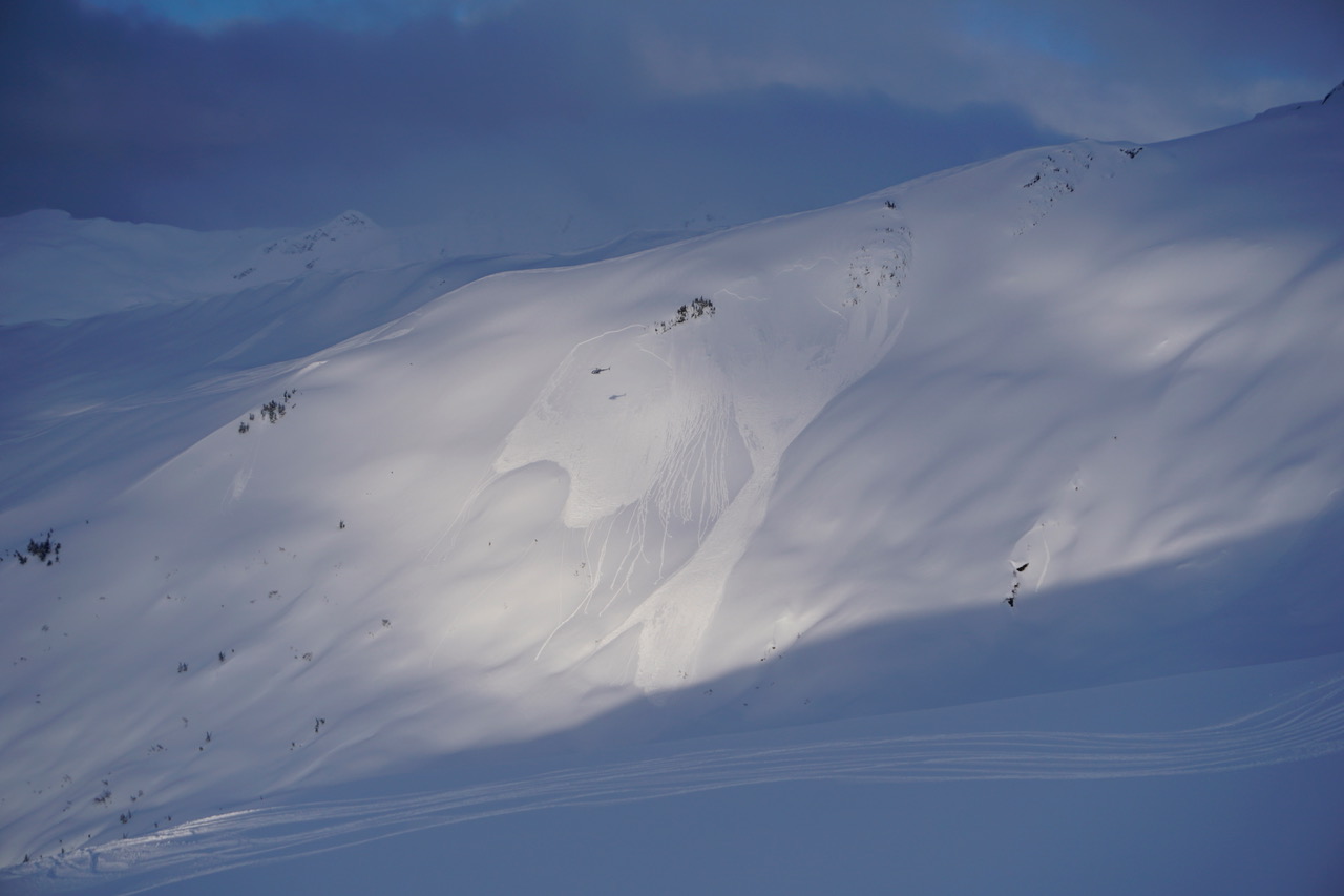
Soft slab avalanche triggered on a steep convex roll on the front side of Eddie’s. The avalanche failed on the layer of buried surface hoar that is present across most of the advisory area. 03.03.2022

Additional Concern
  • Deep Persistent Slabs
    Deep Persistent Slabs
Deep Persistent Slabs
Deep Persistent Slab avalanches are the release of a thick cohesive layer of hard snow (a slab), when the bond breaks between the slab and an underlying persistent weak layer deep in the snowpack. The most common persistent weak layers involved in deep, persistent slabs are depth hoar or facets surrounding a deeply buried crust. Deep Persistent Slabs are typically hard to trigger, are very destructive and dangerous due to the large mass of snow involved, and can persist for months once developed. They are often triggered from areas where the snow is shallow and weak, and are particularly difficult to forecast for and manage.
More info at Avalanche.org

That deep layer of weak, sugary facets that formed back in November is still on our radar, especially in the areas around the fringes of our forecast zone with a generally thinner snowpack. This includes the Crow Creek, Johnson Pass, Lynx Creek, and Slivertip Creek areas, as well as the Summit Lake region which is outside of our forecast zone. Without a major loading event it is unlikely a person will be able to trigger an avalanche on that layer, but it is still worth keeping in mind if you are planning on getting out in any of these areas. Deep slab problems are a real headache to deal with since they are slow to heal and seldom give obvious signs of instability. The only real way to manage a problem like that is to be a little more cautious with your terrain choices than you normally would.

Click here to view the video below describing current snowpack conditions.

Weather
Fri, March 4th, 2022

Yesterday: We had a little bit of everything yesterday, with light snowfall, some periods of sun, and some other times with thick cloud cover. As of 6:00 this morning, weather stations are showing a trace to 2″ new snow since yesterday morning. High temperatures were in the mid 20’s to mid 30’s F, with overnight lows in the low 20’s to low 30’s F. Winds were blowing 10-25 mph out of the east with gusts of 50-55 mph.

Today: Active weather continues today, but wind is going to be the biggest factor. Easterly winds will be blowing 20-30 mph with gusts of 35-50 mph, with a trace to 3″ of new snow in Turnagain Pass and Girdwood, and 6-10″ new snow in the Portage and Placer valleys. The rain line is expected to stay around 300′. Clouds might start to break up later in the day, possibly allowing for some sun to poke through. High temperatures are looking to be in the mid 20’s to mid 30’s F.

Tomorrow: It is looking like tomorrow will be another stormy day, with 2-5″ expected for Girdwood and Turnagain Pass, and 10-14″ in Portage and Placer by the end of the day. Luckily it is looking like the winds will start backing down during the day. The snow level might creep up a little bit, but it should stay below 600′ with high temperatures in the low 20’s to low 30’s F.

PRECIPITATION 24-hour data (6am – 6am)

Temp Avg (F) Snow (in) Water (in) Snow Depth (in)
Center Ridge (1880′) 32 tr 0.1 94
Summit Lake (1400′) 32 0 0 40
Alyeska Mid (1700′) 30 2 0.1 N/A

RIDGETOP 24-hour data (6am – 6am)

Temp Avg (F) Wind Dir Wind Avg (mph) Wind Gust (mph)
Sunburst (3812′) 20 ENE 21 69
Seattle Ridge (2400′) 24 SE 14 30
Observations
Recent Observations for Turnagain Pass
Date Region Location
04/21/24 Turnagain Observation: Bertha Creek
04/20/24 Turnagain Avalanche: Spokane Creek
04/16/24 Turnagain Observation: Cornbiscuit
04/15/24 Turnagain Observation: Taylor Pass
04/15/24 Turnagain Observation: Seward Highway – Tern Lake to Portage
04/14/24 Turnagain Observation: Sunburst
04/14/24 Turnagain Observation: Turnagain Pass Snomo
04/13/24 Turnagain Observation: Spokane Creek
04/11/24 Turnagain Observation: Tincan
04/10/24 Turnagain Avalanche: Seattle Ridge
Riding Areas

The riding areas page has moved. Please click here & update your bookmarks.


Subscribe to Turnagain Pass
Avalanche Forecast by Email

This is a general backcountry avalanche advisory issued for Turnagain Arm with Turnagain Pass as the core advisory area. This advisory does not apply to highways, railroads or operating ski areas.