The avalanche danger is CONSIDERABLE above 1000′. It remains possible for a human to trigger a large and deadly slab avalanche 3′-8’+ deep. New snow forecast for this afternoon into the evening adds load to a snowpack that has concerning deep weak layers. Avoid travel on or under cornices, and in steep terrain consider the need to manage loose surface snow. Conservative decision making and cautious route-finding are essential if headed into the backcountry.
SUMMIT LAKE TO SEWARD REGION: Expect the avalanche danger to remain elevated due to strong winds in the past few days, recent precipitation and poor snowpack structure.
Tue, February 25th, 2020
Alpine
Above 2,500'
3 - Considerable
Treeline
1,000'-2,500'
3 - Considerable
Below Treeline
Below 1,000'
2 - Moderate
0 - No Rating
1 - Low
2 - Moderate
3 - Considerable
4 - High
5 - Extreme
Travel Advice
Generally safe avalanche conditions. Watch for unstable snow on isolated terrain features.
Heightened avalanche conditions on specific terrain features. Evaluate snow and terrain carefully; identify features of concern.
Natural avalanches likely; human-triggered avalanches very likely.
Natural and human-triggered avalanches certain.
Avalanche Size and Distribution
Small avalanches in isolated areas or extreme terrain.
Small avalanches in specific areas; or large avalanches in isolated areas.
Small avalanches in many areas; or large avalanches in specific areas; or very large avalanches in isolated areas.
Large avalanches in many areas; or very large avalanches in specific areas.
Very large avalanches in many areas.
Recent Avalanches
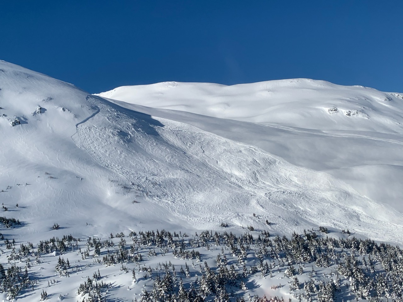
Remotely triggered avalanche above Grandview just south of the Placer Valley. 2.24.2020. Photo: G. Predeger.
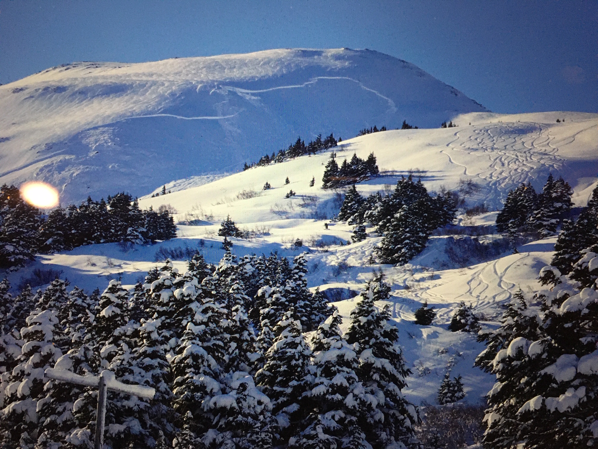
Same remote triggered avalanche viewed from below. 2.24.2020. Photo: W. Wagner
Avalanche Problem 1
Deep Persistent Slabs
Certain
Very Likely
Likely
Possible
Unlikely
Likelihood
Historic (D4-5)
Very Large (D3)
Large (D2)
Small (D1)
Size
Deep Persistent Slabs
Deep Persistent Slab avalanches are the release of a thick cohesive layer of hard snow (a slab), when the bond breaks between the slab and an underlying persistent weak layer deep in the snowpack. The most common persistent weak layers involved in deep, persistent slabs are depth hoar or facets surrounding a deeply buried crust. Deep Persistent Slabs are typically hard to trigger, are very destructive and dangerous due to the large mass of snow involved, and can persist for months once developed. They are often triggered from areas where the snow is shallow and weak, and are particularly difficult to forecast for and manage.
Likelihood of Avalanches
Terms such as "unlikely", "likely", and "certain" are used to define the scale, with the chance of triggering or observing
avalanches increasing as we move up the scale. For our purposes, "Unlikely" means that few avalanches could be triggered in avalanche terrain and
natural avalanches are not expected. "Certain" means that humans will be able to trigger avalanches on many slopes, and natural avalanches are expected.
Size of Avalanches
Avalanche size is defined by the largest potential avalanche, or expected range of sizes related to the problem in question.
Assigned size is a qualitative estimate based on the destructive classification system and requires specialists to estimate the harm avalanches may cause to
hypothetical objects located in the avalanche track (AAA 2016, CAA 2014). Under this schema, "Small" avalanches are not large enough to bury humans and are
relatively harmless unless they carry people over cliffs or through trees or rocks. Moving up the scale, avalanches become "Large" enough to bury, injure,
or kill people. "Very Large" avalanches may bury or destroy vehicles or houses, and "Historic" avalanches are massive events capable of altering the landscape.
Today calls for calm winds, cloudy skies and a chance for 4″-8″ of snow starting this afternoon into the evening.
Our persistent deep slab issue will remain a concern for a while. With colder temperatures, the snowpack is slow to adjust to the wind loading event from 2/23 and the storm snow from 2/18-20. During these events, avalanches were triggered naturally in many areas but not others. As the weather is a limiting contributor to avalanches for most of the daylight hours, what would it take to trigger slopes adjacent to those that haven’t avalanched naturally? Could it be one person on the slope? Yes, it’s possible. Or it could be the 15th person. Like the photos in the recent avalanche section, these deep slabs could be triggered remotely, meaning from a distance above, below, or to the side. Remember, the potential size and consequences of these avalanches could be unsurvivable and warning signs my not exist prior to human trigger.
To avoid these issues, we can play in the powder in the flats or on slopes 30 degrees or less with nothing steeper above us.
If you are headed out into avalanche terrain today, things to remember:
Between 3-8 + feet below your snowmachine or skis sits various layers of weak faceted (sugar) snow. This is why we have a deep persistent slab problem.
In shallower snowpack zones such as Lynx Creek or Summit Lake, it could be much easier to initiate a large slab. As noted above there were both human triggered and natural avalanches in Summit Lake on 2.23.2020. Check out the video below.
Areas near rocks or shallower snowpack areas are likely trigger points. This could be hard to identify and why messing with a deep slab issue is such gamble.
Very large avalanches could be triggered that take out the entire slope and connect to adjacent slopes.
Many slopes have already slid but these could have portions still intact, just waiting for a trigger.
Use safe travel protocol. Travel one at a time in avalanche terrain and spot partners as needed.
Remote triggering is possible (initiating a collapse in the weak layer from the top, side or bottom on the slope resulting in an avalanche) as was the case of the avalanche from the Manitoba skin track yesterday.
You can avoid exposure to this avalanche problem by remaining in the flats or on slopes 30 degrees or less with nothing steeper above.
If you haven’t had a chance to watch this footage of natural avalanches from the Summit Lake area (from 2.23.2020), it’s worth it!:
Wind Slab avalanches are the release of a cohesive layer of snow (a slab) formed by the wind. Wind typically transports snow from the upwind sides of terrain features and deposits snow on the downwind side. Wind slabs are often smooth and rounded and sometimes sound hollow, and can range from soft to hard. Wind slabs that form over a persistent weak layer (surface hoar, depth hoar, or near-surface facets) may be termed Persistent Slabs or may develop into Persistent Slabs.
Likelihood of Avalanches
Terms such as "unlikely", "likely", and "certain" are used to define the scale, with the chance of triggering or observing
avalanches increasing as we move up the scale. For our purposes, "Unlikely" means that few avalanches could be triggered in avalanche terrain and
natural avalanches are not expected. "Certain" means that humans will be able to trigger avalanches on many slopes, and natural avalanches are expected.
Size of Avalanches
Avalanche size is defined by the largest potential avalanche, or expected range of sizes related to the problem in question.
Assigned size is a qualitative estimate based on the destructive classification system and requires specialists to estimate the harm avalanches may cause to
hypothetical objects located in the avalanche track (AAA 2016, CAA 2014). Under this schema, "Small" avalanches are not large enough to bury humans and are
relatively harmless unless they carry people over cliffs or through trees or rocks. Moving up the scale, avalanches become "Large" enough to bury, injure,
or kill people. "Very Large" avalanches may bury or destroy vehicles or houses, and "Historic" avalanches are massive events capable of altering the landscape.
Although the winds are expected to be calm today, wind slabs have formed over the past two days and could be human triggered. Pay attention to wind hardened surface conditions. Look for drifting patterns and pillowed snow. Watch for cracking and listen for hollow sounding snow. Initiating a wind slab in the top couple feet of the snowpack could ‘step down’ and trigger a much larger slide that breaks in the deep weak layers discussed above.
Cornices: These have grown substantially over the past week and could be triggered today. Avoid travel on or underneath. Triggering a cornice fall could also initiate a deep slab on the slope below.
Loose snow avalanches: On slopes protected from the wind, soft snow may easily sluff in steep terrain.
Weather
Tue, February 25th, 2020
Yesterday: Skies were clear with temperatures in the single digits to high teens. Winds were northwest from 5-15 mph becoming calm overnight.
Today: Cloudy skies with a high near 24°F and a low around 16°F. Calm wind becoming northeast around 5 mph in the afternoon before shifting to the east tonight. Snow flurries during the day with accumulation tonight of 5″ to 10″ possible.
Tomorrow: Temperature high near 29°F and low in the teens °F. Calm east wind around 5 mph. 1 to 3″ of snow possible.
This is a general backcountry avalanche advisory issued for Turnagain Arm with Turnagain Pass as the core advisory area.
This advisory does not apply to highways, railroads or operating ski areas.