Turnagain Pass Avalanche Forecast RSS

Archives
ARCHIVED FORECAST - All forecasts expire after 24 hours from the posting date/time.
Issued
Wed, February 26th, 2020 - 7:00AM
Expires
Thu, February 27th, 2020 - 7:00AM
Forecaster
Aleph Johnston-Bloom
Avalanche risk The Bottom Line

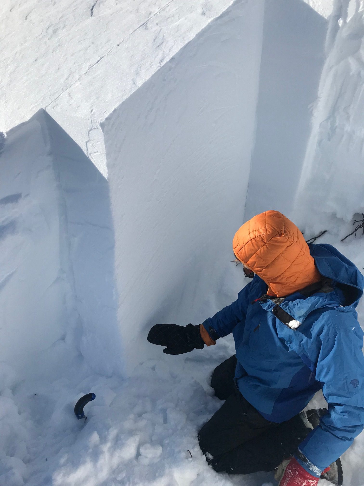
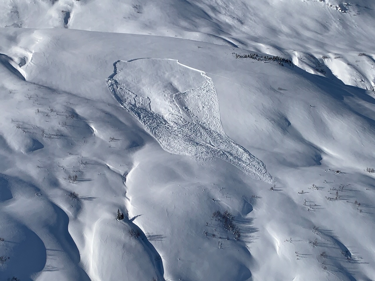
The avalanche danger is CONSIDERABLE today. New snow overnight and moderate winds have made triggering a wind slab likely in steep wind loaded terrain. Natural avalanches are possible as loading continues today. In addition, it remains possible for a human to trigger a large and deadly slab avalanche 3-8+ feet deep on slopes steeper than 30 degrees.  Avoid travel on or under cornices.  Conservative decision making and cautious route-finding are essential.

SUMMIT LAKE TO SEWARD REGION: Expect the avalanche danger to remain elevated due to recent snowfall, strong winds, and poor snowpack structure. Extra caution is advised.

Special Announcements

Our deepest condolences go out to the family, friends, and everyone affected by the fatal avalanche that occurred near Unalaska yesterday.  Media link HERE.

Thanks to our sponsors!
Wed, February 26th, 2020
Alpine
Above 2,500'
Considerable (3)
Avalanche risk
Treeline
1,000'-2,500'
Considerable (3)
Avalanche risk
Below Treeline
Below 1,000'
Considerable (3)
Avalanche risk
Alpine
Above 2,500'
Avalanche risk
Considerable (3)
Treeline
1,000'-2,500'
Avalanche risk
Considerable (3)
Below Treeline
Below 1,000'
Avalanche risk
Considerable (3)
Danger Scale:
No Rating (0)
Low (1)
Moderate (2)
Considerable (3)
High (4)
Extreme (5)
Avalanche Problem 1
  • Deep Persistent Slabs
    Deep Persistent Slabs
  • Almost Certain
    Very Likely
    Likely
    Possible
    Unlikely
    Likelihood
  • Historic (D4-5)
    Very Large (D3)
    Large (D2)
    Small (D1)
    Size
Deep Persistent Slabs
Deep Persistent Slab avalanches are the release of a thick cohesive layer of hard snow (a slab), when the bond breaks between the slab and an underlying persistent weak layer deep in the snowpack. The most common persistent weak layers involved in deep, persistent slabs are depth hoar or facets surrounding a deeply buried crust. Deep Persistent Slabs are typically hard to trigger, are very destructive and dangerous due to the large mass of snow involved, and can persist for months once developed. They are often triggered from areas where the snow is shallow and weak, and are particularly difficult to forecast for and manage.

Likelihood of Avalanches
Terms such as "unlikely", "likely", and "certain" are used to define the scale, with the chance of triggering or observing avalanches increasing as we move up the scale. For our purposes, "Unlikely" means that few avalanches could be triggered in avalanche terrain and natural avalanches are not expected. "Certain" means that humans will be able to trigger avalanches on many slopes, and natural avalanches are expected.

Size of Avalanches
Avalanche size is defined by the largest potential avalanche, or expected range of sizes related to the problem in question. Assigned size is a qualitative estimate based on the destructive classification system and requires specialists to estimate the harm avalanches may cause to hypothetical objects located in the avalanche track (AAA 2016, CAA 2014). Under this schema, "Small" avalanches are not large enough to bury humans and are relatively harmless unless they carry people over cliffs or through trees or rocks. Moving up the scale, avalanches become "Large" enough to bury, injure, or kill people. "Very Large" avalanches may bury or destroy vehicles or houses, and "Historic" avalanches are massive events capable of altering the landscape.

Signal Word Size (D scale) Simple Descriptor
Small 1 Unlikely to bury a person
Large 2 Can bury a person
Very Large 3 Can destroy a house
Historic 4 & 5 Can destroy part or all of a village
More info at Avalanche.org

Yesterday was the first day in over a week that there was no large (D2) or very large (D3) avalanches reported. There have been some impressive and scary avalanches triggered by snow and wind loading, explosives and remotely by skiers.  If you have been following along with the forecast you know we are still concerned that someone will find the wrong spot on their skis or snowmachine, trigger one of these beasts and get caught. That worry continues today. It has snowed 6-12″ last night and winds were easterly 10-20 mph with gusts in to the 30s and 40s. Fresh wind slabs are likely in wind loaded terrain (more on that below in Avalanche Problem 2). There is also older wind hardened snow below.  A person on skis or snowmachine could initiate a wind slab in the top 1-2′ of the snowpack that might ‘step down’ and trigger a much larger slide on a deep weak layer 3-8+ feet down. It doesn’t have to be an avalanche in the upper snowpack. It could also just be the 1st, 10th or 20th person on the slope. Because it is hard to know what will actually tip the balance with a deep persistent slab problem is is important to remember a natural avalanche could also occur today as snow and wind loading continue. The advice for the day with poor visibility is avoid travel in runout zones and don’t forget that avalanches have been triggered remotely, think about what the terrain you are on is connected to. Cautious route-finding and conservative decision making are essential. Use safe travel protocol and consider terrain consequences if a large avalanche were to occur. Where would you end up?

The January facet layer was 3′ down from the surface at 2500′ on Fresno in Summit Lake. 2.24.20. 

Remote triggered avalanche above Grandview just south of Placer Valley. 2.24.20. Photo: Graham Predeger. This remote triggered slab is just up-ridge of the site of the double fatality ten years ago on Feb 13th, 2010. Link HERE. 

Avalanche Problem 2
  • Wind Slabs
    Wind Slabs
  • Almost Certain
    Very Likely
    Likely
    Possible
    Unlikely
    Likelihood
  • Historic (D4-5)
    Very Large (D3)
    Large (D2)
    Small (D1)
    Size
Wind Slabs
Wind Slab avalanches are the release of a cohesive layer of snow (a slab) formed by the wind. Wind typically transports snow from the upwind sides of terrain features and deposits snow on the downwind side. Wind slabs are often smooth and rounded and sometimes sound hollow, and can range from soft to hard. Wind slabs that form over a persistent weak layer (surface hoar, depth hoar, or near-surface facets) may be termed Persistent Slabs or may develop into Persistent Slabs.

Likelihood of Avalanches
Terms such as "unlikely", "likely", and "certain" are used to define the scale, with the chance of triggering or observing avalanches increasing as we move up the scale. For our purposes, "Unlikely" means that few avalanches could be triggered in avalanche terrain and natural avalanches are not expected. "Certain" means that humans will be able to trigger avalanches on many slopes, and natural avalanches are expected.

Size of Avalanches
Avalanche size is defined by the largest potential avalanche, or expected range of sizes related to the problem in question. Assigned size is a qualitative estimate based on the destructive classification system and requires specialists to estimate the harm avalanches may cause to hypothetical objects located in the avalanche track (AAA 2016, CAA 2014). Under this schema, "Small" avalanches are not large enough to bury humans and are relatively harmless unless they carry people over cliffs or through trees or rocks. Moving up the scale, avalanches become "Large" enough to bury, injure, or kill people. "Very Large" avalanches may bury or destroy vehicles or houses, and "Historic" avalanches are massive events capable of altering the landscape.

Signal Word Size (D scale) Simple Descriptor
Small 1 Unlikely to bury a person
Large 2 Can bury a person
Very Large 3 Can destroy a house
Historic 4 & 5 Can destroy part or all of a village
More info at Avalanche.org

As mentioned above, new snow and wind overnight have likely formed tender wind slabs in leeward terrain that will be easy to trigger.  Pay attention to surface wind effect and watch for cracking. Is there harder snow over softer snow? Is there blowing snow and loading happening while you are out?

Storm slabs and loose snow avalanches: On slopes protected from the wind, soft snow may be cohesive enough to have formed shallow storm slabs that could easily slide in steep terrain or if still loose easily sluff in steep terrain.

Cornices:  These have grown substantially over the past week and could be triggered today.  Avoid travel on or underneath. Triggering a cornice fall could also initiate a deep slab on the slope below.


Weather
Wed, February 26th, 2020

Yesterday: Skies went from partly cloudy to mostly cloudy and snow showers started in the late afternoon. 6-12″ fell overnight favoring Portage. Winds were easterly 10-20 mph with gusts in the 30s and 40s. Temperatures started  in the single digits and climbed into the 20°Fs.

Today: Snow continues today with another 2-8″ possible. Easterly winds will continue blowing 10-20 mph with gusts into the 30s and then diminish overnight. Temperatures will be in the 20°Fs to low 30°Fs. Light snow showers continue overnight with temperatures in the 20°Fs and hight teens.

Tomorrow: Snow showers in the morning becoming partly cloudy in the afternoon. Temperatures in the 20°Fs. Winds are mostly light and shift to the west with clearing skies. Temperatures drop into the the single digits overnight. There is a chance of another outflow event and mostly clear skies for Friday and Saturday.

PRECIPITATION 24-hour data (6am – 6am)

Temp Avg (F) Snow (in) Water (in) Snow Depth (in)
Center Ridge (1880′) 24 6 0.4 83
Summit Lake (1400′) 17 2 0.2 32
Alyeska Mid (1700′) 20 4 0.4 88

RIDGETOP 24-hour data (6am – 6am)

Temp Avg (F) Wind Dir Wind Avg (mph) Wind Gust (mph)
Sunburst (3812′) 17 NE 17 47
Seattle Ridge (2400′) 19 *NA *NA *NA

*Seattle Ridge anemometer (wind sensor) is rimed over and not reporting.

Observations
Recent Observations for Turnagain Pass
Date Region Location
05/22/23 Turnagain Avalanche: Tincan
05/12/23 Turnagain Avalanche: Tincan, Sunburst, Magnum, Cornbiscuit
05/07/23 Turnagain Observation: Tincan – Bear Tracks
05/05/23 Turnagain Observation: Seattle Ridge
05/02/23 Turnagain Observation: Cornbiscuit
05/02/23 Turnagain Observation: Seward Hwy Turnagain Pass
04/30/23 Turnagain Observation: Magnum
04/29/23 Turnagain Observation: Tincan
04/28/23 Turnagain Avalanche: Taylor Pass/Pastoral
04/28/23 Turnagain Avalanche: Tincan
Riding Areas
Updated Mon, May 15th, 2023

Status of riding areas across the Chugach NF is managed by the Glacier and Seward Ranger Districts, not avalanche center staff. Riding area information is posted as a public service to our users and updated based on snow depth and snow density to prevent resource damage at trailhead locations. Riding area questions contact: mailroom_r10_chugach@fs.fed.us

Area Status Weather & Riding Conditions
Glacier District
Johnson Pass
Closed
Closed May 15.
Placer River
Closed
Closed May 15.
Skookum Drainage
Closed
Will close to motorized use on April 1, 2023 per the National Forest Plan.
Turnagain Pass
Open
Chugach NF staff will be assessing daily after May 15th. Please keep machines on the snow and avoid brown spots to keep this area open as long as possible.
Twentymile
Closed
Scheduled closure May 1.
Seward District
Carter Lake
Closed
Scheduled closure May 1.
Lost Lake Trail
Closed
Scheduled closure May 1.
Primrose Trail
Closed
Scheduled closure May 1.
Resurrection Pass Trail
Closed
Closed to motorized use for the 2022/23 winter season per Forest Plan. Open next season.
Snug Harbor
Closed
Extended opening until May 15.
South Fork Snow River Corridor
Closed
Scheduled closure May 1.
Summit Lake
Closed
Scheduled closure May 1.

Subscribe to Turnagain Pass
Avalanche Forecast by Email

This is a general backcountry avalanche advisory issued for Turnagain Arm with Turnagain Pass as the core advisory area. This advisory does not apply to highways, railroads or operating ski areas.