Turnagain Pass Avalanche Forecast
|
![]() ![]() |
We have issued a Special Avalanche Bulletin through the National Weather Service for the Turnagain Pass area and surrounding mountains.
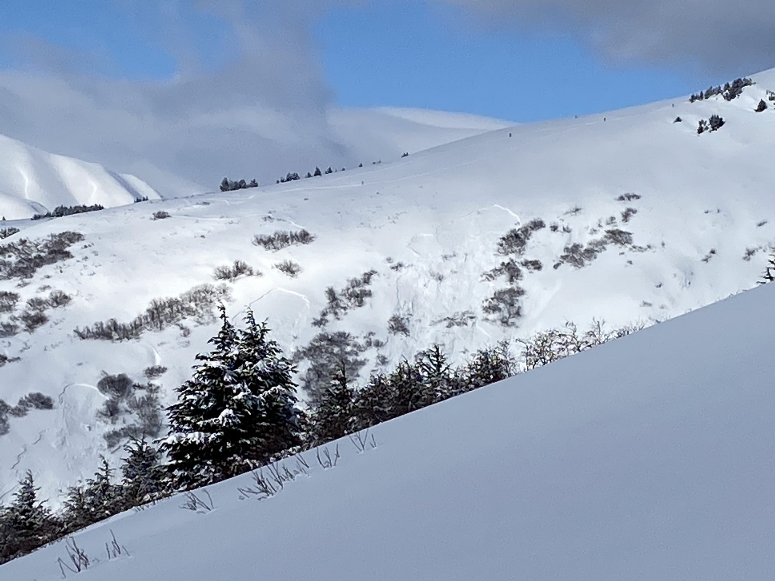
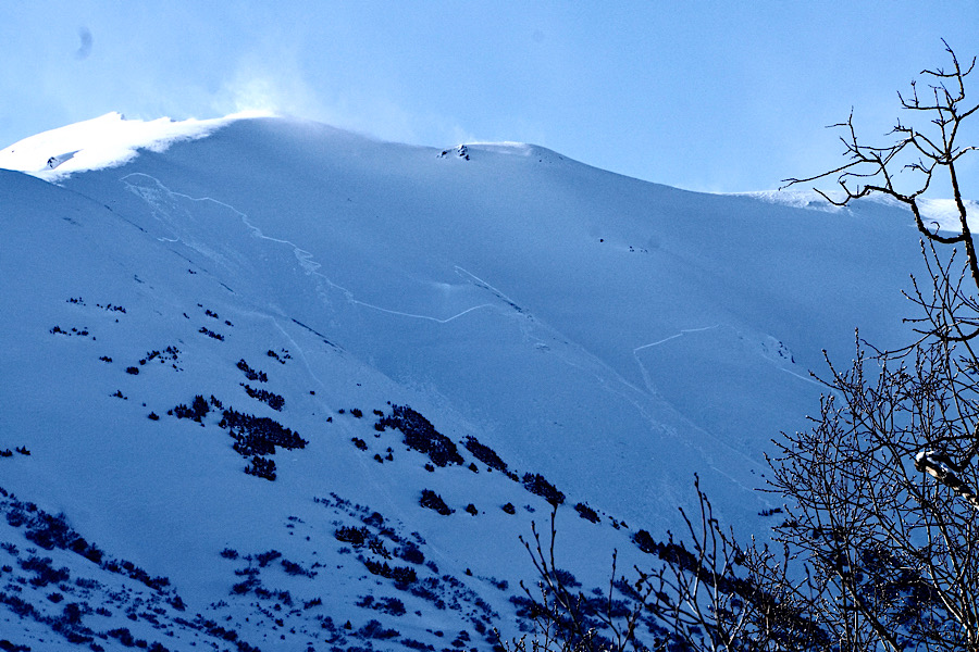
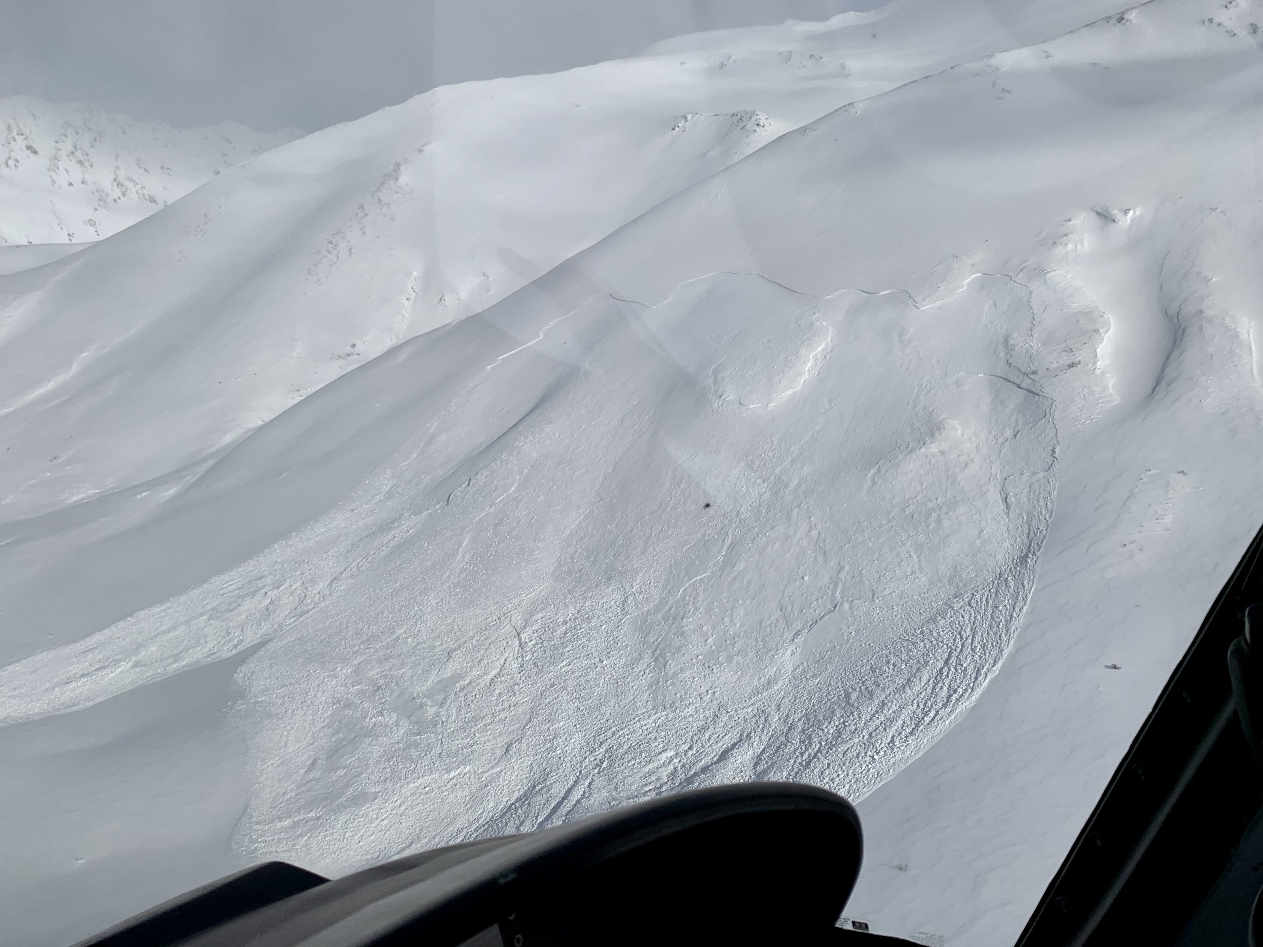
Today the avalanche danger is CONSIDERABLE above 1000′ due to the potential size and consequences of triggering an avalanche. It remains possible for a human to trigger a large and deadly slab avalanche 3-8+ deep on slopes 30 degrees or steeper. Watch for lingering wind slabs in leeward terrain and avoid travel on or under cornices. Conservative decision making and cautious route-finding are essential if headed into the backcountry.
SUMMIT LAKE TO SEWARD REGION: Expect the avalanche danger to remain elevated due to yesterday’s strong winds, recent precipitation and poor snowpack structure.
Both human and natural avalanches occurred in Summit Lake yesterday. A party skinning on the ridge of Manitoba remote triggered avalanches on the slope below and an impressive series of natural avalanches triggered by the northwest winds were observed on Fresno from the highway.
Signal Word | Size (D scale) | Simple Descriptor |
Small | 1 | Unlikely to bury a person |
Large | 2 | Can bury a person |
Very Large | 3 | Can destroy a house |
Historic | 4 & 5 | Can destroy part or all of a village |
Despite the lure of sunny skies and people starting to poke into avalanche terrain is imperative to keep the consequences of triggering a large avalanche in your mind today. It is still possible to trigger a deep, unsurvivable avalanche. This why we have issued the Special Avalanche Bulletin and why the avalanche danger remains at CONSIDERABLE. The travel advice advice associated with this danger level is the key to staying safe; cautious route-finding and conservative decision making are essential. Picture a large avalanche anywhere from 3-8+ feet deep on the piece of terrain you are thinking of traveling on. Before you head out today look at the observations from the past week and imagine triggering one of the avalanches pictured. Big thanks to everyone sending in information this weekend!
If you are headed out into avalanche terrain today, things to remember:
Signal Word | Size (D scale) | Simple Descriptor |
Small | 1 | Unlikely to bury a person |
Large | 2 | Can bury a person |
Very Large | 3 | Can destroy a house |
Historic | 4 & 5 | Can destroy part or all of a village |
Yesterday gusty NW winds created plumes off of the peaks, formed tender wind slabs and triggered avalanches in Summit Lake. Today it still possible to trigger a wind slab in steep wind loaded terrain. Northwest winds can be a bit funky and load from the south on the east side of Turnagain pass. Pay attention to wind hardened surface conditions. Look for drifting patterns and pillowed snow. Watch for cracking and listen for hollow sounding snow. Initiating a wind slab in the top couple feet of the snowpack could ‘step down’ and trigger a much larger slide that breaks in the deep weak layers discussed above.
Cornices: These have grown substantially over the past week and could be triggered today. Avoid travel on or underneath. Triggering a cornice fall could also initiate a deep slab on the slope below.
Loose snow avalanches: On slopes protected from the wind, soft snow may easily sluff in steep terrain.
Yesterday: Skies were partly cloudy. Temperatures were in the single digits to low teens. Winds were northwesterly 10-20 mph gusting into the 30s. Overnight skies were mostly clear and temps dropped down to single digits and in some valley locations below 0°F. Northwest winds eased to 5-10 mph.
Today: Clear skies with temperatures in the single digits to high teens. Northwest wind 5-15 mph becoming calm overnight. Skies will be partly cloudy overnight and temperatures will be in the single digits and low teens.
Tomorrow: Skies will be mostly cloudy with snow starting in the late afternoon. Winds will start light and northwesterly and then shift to the east blowing 10-20 mph with gusts into the 30s. There is the potential for heavy snow and strong winds overnight into Wednesday with the storm ending Wednesday night.
PRECIPITATION 24-hour data (6am – 6am)
Temp Avg (F) | Snow (in) | Water (in) | Snow Depth (in) | |
---|---|---|---|---|
Center Ridge (1880′) | 11 | 0 | 0 | 80 |
Summit Lake (1400′) | 7 | 0 | 0 | 31 |
Alyeska Mid (1700′) | 9 | 0 | 0 | 86 |
RIDGETOP 24-hour data (6am – 6am)
Temp Avg (F) | Wind Dir | Wind Avg (mph) | Wind Gust (mph) | |
---|---|---|---|---|
Sunburst (3812′) | 0 | NW | 10 | 30 |
Seattle Ridge (2400′) | 5 | *NA | *NA | *NA |
*Seattle Ridge anemometer (wind sensor) is rimed over and not reporting.
Date | Region | Location | Observer |
---|---|---|---|
05/22/23 | Turnagain | Avalanche: Tincan | Nick D'Alessio |
05/12/23 | Turnagain | Avalanche: Tincan, Sunburst, Magnum, Cornbiscuit | Heather Thamm |
05/07/23 | Turnagain | Observation: Tincan – Bear Tracks | CNFAIC Staff |
05/05/23 | Turnagain | Observation: Seattle Ridge | AS/ WW Forecaster |
05/02/23 | Turnagain | Observation: Cornbiscuit | Schauer/ Sturgess Forecaster |
05/02/23 | Turnagain | Observation: Seward Hwy Turnagain Pass | Joel Curtis |
04/30/23 | Turnagain | Observation: Magnum | Ayla, Kit Crosby, Barton |
04/29/23 | Turnagain | Observation: Tincan | John Sykes |
04/28/23 | Turnagain | Avalanche: Taylor Pass/Pastoral | Schauer/ Creighton Forecaster |
04/28/23 | Turnagain | Avalanche: Tincan | Andy Moderow |
Status of riding areas across the Chugach NF is managed by the Glacier and Seward Ranger Districts, not avalanche center staff. Riding area information is posted as a public service to our users and updated based on snow depth and snow density to prevent resource damage at trailhead locations. Riding area questions contact: mailroom_r10_chugach@fs.fed.us
Area | Status | Weather & Riding Conditions |
---|---|---|
Glacier District |
Subscribe to Turnagain Pass
Avalanche Forecast by Email
This is a general backcountry avalanche advisory issued for Turnagain Arm with Turnagain Pass as the core advisory area. This advisory does not apply to highways, railroads or operating ski areas.