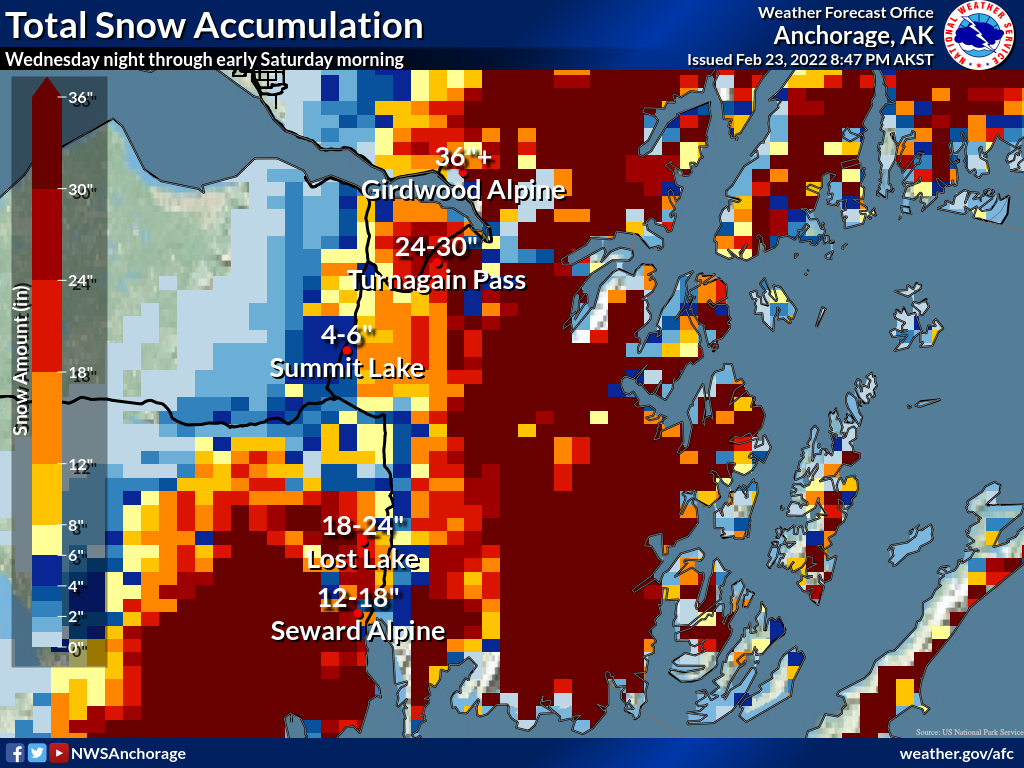
Turnagain Pass RSS

Archives
ARCHIVED - Forecasts expire after 24 hours.
Issued
Thu, February 24th, 2022 - 7:00AM
Expires
Fri, February 25th, 2022 - 7:00AM
Forecaster
John Sykes
Avalanche Warning
Issued: February 24, 2022 6:00 pm
Travel in avalanche terrain is not recommended. Avoid being on or beneath all steep slopes.
Avalanche risk The Bottom Line

6pm UPDATE:
The avalanche danger is rising to HIGH overnight due to increasing snowfall, rain and wind. An Avalanche Warning has been issued beginning at 6pm today, Thursday, that will extend through tomorrow, Friday.

The avalanche danger is CONSIDERABLE at all elevations today and will likely rise to HIGH this evening and into tomorrow as snowfall totals start to add up. Human triggered avalanches 2-3′ deep in areas with fresh wind loading are likely and natural avalanches are possible. The potential for avalanches to release on deeper weak layers and create very large avalanches 3-6′ deep also exists in areas with a weaker overall snowpack. Conservative decision-making and careful terrain and snowpack evaluation are essential for safe travel today.

The avalanche danger is expected to rise overnight and remain elevated throughout the day on Friday.

PORTAGE/PLACER: Very heavy snowfall during the day today will create elevated avalanche danger and this area will rise to HIGH danger earlier than the rest of the forecast zone. Human triggered avalanches will be very likely once a foot or more of new snow piles up and natural avalanches will be likely from new snow and wind loading. Travel in avalanche terrain is not recommended.

CROW PASS ZONE: Strong winds today and over the next 48 hours will create elevated avalanche hazard in the Crow Creek area, which already has a weak snowpack and has seen large natural avalanches in the past week.

Thu, February 24th, 2022
Alpine
Above 2,500'
4 - High
Avalanche risk
Treeline
1,000'-2,500'
4 - High
Avalanche risk
Below Treeline
Below 1,000'
4 - High
Avalanche risk
0 - No Rating
1 - Low
2 - Moderate
3 - Considerable
4 - High
5 - Extreme
Avalanche risk Avalanche risk Avalanche risk Avalanche risk Avalanche risk
Travel Advice Generally safe avalanche conditions. Watch for unstable snow on isolated terrain features. Heightened avalanche conditions on specific terrain features. Evaluate snow and terrain carefully; identify features of concern. Dangerous avalanche conditions. Careful snowpack evaluation, cautious route-finding, and conservative decision-making essential. Very dangerous avalanche conditions. Travel in avalanche terrain not recommended. Extraordinarily dangerous avalanche conditions. Avoid all avalanche terrain.
Likelihood of Avalanches Natural and human-triggered avalanches unlikely. Natural avalanches unlikely; human-triggered avalanches possible. Natural avalanches possible; human-triggered avalanches likely. Natural avalanches likely; human-triggered avalanches very likely. Natural and human-triggered avalanches certain.
Avalanche Size and Distribution Small avalanches in isolated areas or extreme terrain. Small avalanches in specific areas; or large avalanches in isolated areas. Small avalanches in many areas; or large avalanches in specific areas; or very large avalanches in isolated areas. Large avalanches in many areas; or very large avalanches in specific areas. Very large avalanches in many areas.
Avalanche Problem 1
  • Storm Slabs
    Storm Slabs
  • Certain
    Very Likely
    Likely
    Possible
    Unlikely
    Likelihood
  • Historic (D4-5)
    Very Large (D3)
    Large (D2)
    Small (D1)
    Size
Storm Slabs
Storm Slab avalanches are the release of a cohesive layer (a slab) of new snow that breaks within new snow or on the old snow surface. Storm-slabs typically last between a few hours and few days (following snowfall). Storm-slabs that form over a persistent weak layer (surface hoar, depth hoar, or near-surface facets) may be termed Persistent Slabs or may develop into Persistent Slabs.

Likelihood of Avalanches
Terms such as "unlikely", "likely", and "certain" are used to define the scale, with the chance of triggering or observing avalanches increasing as we move up the scale. For our purposes, "Unlikely" means that few avalanches could be triggered in avalanche terrain and natural avalanches are not expected. "Certain" means that humans will be able to trigger avalanches on many slopes, and natural avalanches are expected.

Size of Avalanches
Avalanche size is defined by the largest potential avalanche, or expected range of sizes related to the problem in question. Assigned size is a qualitative estimate based on the destructive classification system and requires specialists to estimate the harm avalanches may cause to hypothetical objects located in the avalanche track (AAA 2016, CAA 2014). Under this schema, "Small" avalanches are not large enough to bury humans and are relatively harmless unless they carry people over cliffs or through trees or rocks. Moving up the scale, avalanches become "Large" enough to bury, injure, or kill people. "Very Large" avalanches may bury or destroy vehicles or houses, and "Historic" avalanches are massive events capable of altering the landscape.

Signal Word Size (D scale) Simple Descriptor
Small 1 Unlikely to bury a person
Large 2 Can bury a person
Very Large 3 Can destroy a house
Historic 4 & 5 Can destroy part or all of a village
More info at Avalanche.org

Avalanche danger is going to be increasing throughout the day today as snowfall starts to pile up and strong winds impact the area.  Snow totals are expected to be in the 4-6″ range during daylight hours for Turnagain Pass and Girdwood, but favored areas like Portage and Placer could see closer to 16″ of snowfall today. This is just the opening salvo of a storm system that is expected to drop 2-4′ of snow in Turnagain and Girdwood over the next 48 hours, with the latest forecasts preferring Girdwood for snowfall. Favored areas like Portage and Placer could see up to 6′ of snow over the next 48 hours. Snow line should fluctuate between 500 – 1200′ during the storm. Strong winds will accompany the snowfall, and we have already seen averages of 20-35 mph and gusts of 40-60 mph at ridgetops over the past 12 hours. Winds speeds are expected to remain strong today and then increase overnight during the peak of the precipitation.

Human triggered avalanches up to 2-3′ deep will be trending towards very likely and natural avalanches will be likely in areas with rapid loading of new snow and wind. Areas with a weak snowpack structure could see very large avalanches releasing in deeper weak layers (see problem 2 for more details). We recommend conservative decision-making and careful terrain and snowpack evaluation today as the storm starts to impact the area. In areas getting heavy snowfall today, like Portage and Placer, we recommend avoiding avalanche terrain as the conditions could deteriorate quickly in these areas.

Wind Slabs: Strong winds over the past 12 hours have redistributed the surface snow into fresh wind slabs up to 3′ deep, especially at upper elevations. Likely areas to find wind slabs are along ridgelines, in cross loaded gullies, and convex terrain features. Look for shooting cracks, hollow feeling snow, and signs of wind transport on the snow surface to identify areas with fresh wind slabs.

Storm Slabs: As snowfall totals start to increase this evening and overnight the potential for avalanches in protected areas at the interface of the old snow surface will be increasing. If heavy snowfall arrives earlier than expected this could start to be an issue today, otherwise we expect that storm slabs in the new snow will be a bigger issue overnight and tomorrow.

Snowfall totals from Wednesday evening through Saturday morning. Courtesy of NWS Anchorage 2.23.22

Avalanche Problem 2
  • Persistent Slabs
    Persistent Slabs
  • Certain
    Very Likely
    Likely
    Possible
    Unlikely
    Likelihood
  • Historic (D4-5)
    Very Large (D3)
    Large (D2)
    Small (D1)
    Size
Persistent Slabs
Persistent Slab avalanches are the release of a cohesive layer of snow (a slab) in the middle to upper snowpack, when the bond to an underlying persistent weak layer breaks. Persistent layers include: surface hoar, depth hoar, near-surface facets, or faceted snow. Persistent weak layers can continue to produce avalanches for days, weeks or even months, making them especially dangerous and tricky. As additional snow and wind events build a thicker slab on top of the persistent weak layer, this avalanche problem may develop into a Deep Persistent Slab.

Likelihood of Avalanches
Terms such as "unlikely", "likely", and "certain" are used to define the scale, with the chance of triggering or observing avalanches increasing as we move up the scale. For our purposes, "Unlikely" means that few avalanches could be triggered in avalanche terrain and natural avalanches are not expected. "Certain" means that humans will be able to trigger avalanches on many slopes, and natural avalanches are expected.

Size of Avalanches
Avalanche size is defined by the largest potential avalanche, or expected range of sizes related to the problem in question. Assigned size is a qualitative estimate based on the destructive classification system and requires specialists to estimate the harm avalanches may cause to hypothetical objects located in the avalanche track (AAA 2016, CAA 2014). Under this schema, "Small" avalanches are not large enough to bury humans and are relatively harmless unless they carry people over cliffs or through trees or rocks. Moving up the scale, avalanches become "Large" enough to bury, injure, or kill people. "Very Large" avalanches may bury or destroy vehicles or houses, and "Historic" avalanches are massive events capable of altering the landscape.

Signal Word Size (D scale) Simple Descriptor
Small 1 Unlikely to bury a person
Large 2 Can bury a person
Very Large 3 Can destroy a house
Historic 4 & 5 Can destroy part or all of a village
More info at Avalanche.org

With the added weight of new snow and wind loading over the next 48 hours we could see buried weak layers reactivating and producing large avalanches. We investigated a large avalanche in Crow Creek on Goat Shoulder yesterday that was 3-4′ deep, 700′ wide, and ran 2000′ to the valley bottom (see ob here). This avalanche released naturally on a layer of buried facets from November that are a major concern in areas with a shallow overall snowpack throughout the region, such as Crown Pass, Lynx Creek, Silvertip Creek, and the southern end of Seattle Ridge. In addition, this weak layer is a major concern outside our forecast zone in the Summit Lake area and interior Kenai Peninsula in general. The combination of weak November facets on top of a firm and consistent crust from the Halloween storm give this layer the potential to produce avalanches that propagate very widely and run out all the way to valley bottoms. It is likely that storm snow or wind slab avalanches releasing in the new snow could step down to these deeper weak layers and produce a much larger avalanche than expected.

Several thin crusts in the upper snowpack formed by rain, rime, or warm temperatures also have the potential to harbor weak layers either above or below the crust and produce wider propagating avalanches than a normal wind slab or storm slab. The best way to evaluate these layers is using instability tests in a snow pit to assess the potential for propagation in the area you are travelling.

Checking out the crown of the large avalanche from Monday evening on Goat Shoulder, see ob here for details. Photo 2.23.22

Weather
Thu, February 24th, 2022

Yesterday: Broken to overcast clouds with light flurries starting in the afternoon. Winds were moderate at upper elevations until around 5 pm when average wind speed increased to 20-30 mph with gusts to 40-60 mph. Temperatures were in the 20s at ridgetops and around or just above freezing at treeline elevations.

Today: A major snowfall event is moving into the area today, with precipitation expected throughout the day and intensity increasing this evening and overnight tonight. Current forecasts are calling for 4-6″ of snow during the day today in Turnagain Pass and Girdwood areas. In Portage and Placer today’s snowfall could be closer to 16″ before sunset. Snow line should be between 500 – 1200′ today. High winds will accompany the snow with averages in the 40 – 50 mph range at ridgetops today and gusts of 70+ mph.

Tomorrow: This storm is going to keep on pumping moisture into our area, with potential for 3′ of snow over the next 48 hours. In favored areas like Portage and Placer storm totals could be closer to 4-6′. Snow line should remain between 500- 1200′ for the next two day. Strong winds will continue through Friday evening before the snowfall starts to taper off.

PRECIPITATION 24-hour data (6am – 6am)

Temp Avg (F) Snow (in) Water (in) Snow Depth (in)
Center Ridge (1880′) 34 1 0.1 93
Summit Lake (1400′) 35 0 0.2 44
Alyeska Mid (1700′) 33 1 0.1 NA

RIDGETOP 24-hour data (6am – 6am)

Temp Avg (F) Wind Dir Wind Avg (mph) Wind Gust (mph)
Sunburst (3812′) 23 ENE 23 61
Seattle Ridge (2400′) 25 SE 18 36
Observations
Recent Observations for Turnagain Pass
Date Region Location
04/16/24 Turnagain Observation: Cornbiscuit
04/15/24 Turnagain Observation: Taylor Pass
04/15/24 Turnagain Observation: Seward Highway – Tern Lake to Portage
04/14/24 Turnagain Observation: Sunburst
04/14/24 Turnagain Observation: Turnagain Pass Snomo
04/13/24 Turnagain Observation: Spokane Creek
04/11/24 Turnagain Observation: Tincan
04/10/24 Turnagain Avalanche: Seattle Ridge
04/10/24 Turnagain Observation: Cornbiscuit South Face
04/10/24 Turnagain Avalanche: Tincan
Riding Areas

The riding areas page has moved. Please click here & update your bookmarks.


Subscribe to Turnagain Pass
Avalanche Forecast by Email

This is a general backcountry avalanche advisory issued for Turnagain Arm with Turnagain Pass as the core advisory area. This advisory does not apply to highways, railroads or operating ski areas.