Turnagain Pass Avalanche Forecast
|
![]() ![]() |
We have issued a Special Avalanche Bulletin through the National Weather Service for the Turnagain Pass area and surrounding mountains.
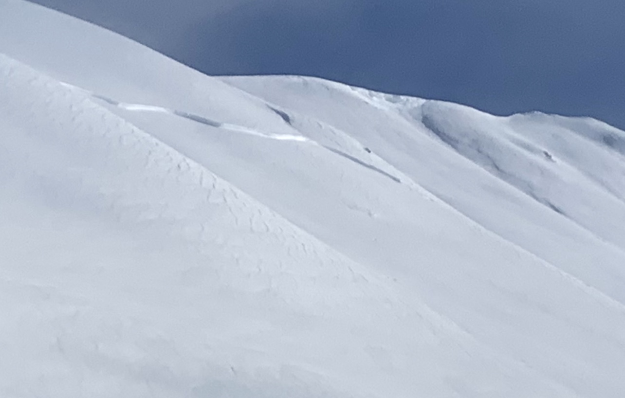
Today the avalanche danger is CONSIDERABLE at all elevations from Girdwood, though Turnagain Pass to Seward. Steady northwest winds throughout the day are expected to create wind slabs that could release naturally or likely triggered by a person. It remains possible for a human to trigger a large and deadly slab avalanche 3-6′ thick on slopes 30 degrees or steeper. Conservative decision making and route-finding continues to be essential if headed into the backcountry.
SUMMIT LAKE TO SEWARD REGION: Expect the avalanche danger to remain elevated due to strong winds and recent precipitation.
REGION-WIDE: Dangerous avalanche conditions remain in many areas of Southcentral. If you are headed to Hatcher Pass, don’t forget to check out HPAC’s Saturday Forecast and Facebook Page!
Signal Word | Size (D scale) | Simple Descriptor |
Small | 1 | Unlikely to bury a person |
Large | 2 | Can bury a person |
Very Large | 3 | Can destroy a house |
Historic | 4 & 5 | Can destroy part or all of a village |
Cold temperatures and moderate to strong northwest winds are expected today from 20-25+mph and will be capable of transporting surface snow. With all this fresh snow, we can expect to find new touchy wind slabs around 1-2′ thick. In areas seeing snow pluming off the peaks and ridges, natural wind slab avalanches are possible. This is most likely south and north of Turnagain Pass in areas such as Summit Lake, Lost Lake and Girdwood. Additionally, there still could be older wind slabs or storm slabs lingering from last week’s storm. If a wind slab or other slab releases in the top few feet of the snowpack, it could ‘step down’ and trigger a much larger slide that breaks in deep weak layers; more on that below.
Cornices: These have grown substantially over the past week and could easily be triggered. If making it to the ridgelines, be sure to give these features a very wide berth.
Signal Word | Size (D scale) | Simple Descriptor |
Small | 1 | Unlikely to bury a person |
Large | 2 | Can bury a person |
Very Large | 3 | Can destroy a house |
Historic | 4 & 5 | Can destroy part or all of a village |
3-5 feet of new snow accumulated from 2/18-20 and has added to forming a thick deep slab over weak faceted snow from January. The storm cycle this week naturally triggered many steeper slopes to avalanche. Many steep slopes didn’t avalanche, and may not take much load to initiate. If todays clear skies draw us into the mountains, it’s easiest to avoid these issues by remaining in the flats or on slopes 30 degrees or less with nothing steeper above.
The natural cycle we had a glimpse of Thursday afternoon proves that the snowpack isn’t stable. Many of the avalanches had crowns 5-8′ thick, were rated ‘very large’ and stepped down into buried weak snow. In shallower snowpack zones such as Lynx Creek or Summit Lake, it could be much easier to initiate a large slab. Yesterday a party felt many large whumpfs in Summit Lake.
If you are headed out into avalanche terrain today, things to remember:
This slab avalanche was naturally triggered sometime in the range of 2/18-20 on a southwest facing aspect of Sunburst. This slope is frequented by skiers. What will it take to initiate the adjacent slopes? 2/22/2020 . Photo: Kellie Okonek
Pictured here is one slab of many naturally triggered avalanches that occurred earlier in the week. Many steep areas that haven’t avalanched could still be near the tipping point. 2/22/2020 . Photo: E. Roberts
Yesterday: Skies were partly cloudy with a few snow flurries but no accumulation. Ridgetop winds were out of the east in the 10-15mph range with gusts to 25mph. Temperatures were mostly in the teens °F to single digits in the evening.
Today: Isolated snow showers are expected in the morning but mostly sunny today, with a high near 12°F and a low of -11°F. Winds will be out of the northwest and expected to be 20 to 25 mph.
Tomorrow: Sunny skies are forecast with a high near 16°F and low near 0°F. Winds are expected to be from the Southwest at 5 mph, then shifting to easterly in the evening as clouds roll into the region.
PRECIPITATION 24-hour data (6am – 6am)
Temp Avg (F) | Snow (in) | Water (in) | Snow Depth (in) | |
---|---|---|---|---|
Center Ridge (1880′) | 15 | 1 | 0.1 | 83 |
Summit Lake (1400′) | 12 | 0 | 0 | 30 |
Alyeska Mid (1700′) | 15 | 1 | 0.14 | 90 |
RIDGETOP 24-hour data (6am – 6am)
Temp Avg (F) | Wind Dir | Wind Avg (mph) | Wind Gust (mph) | |
---|---|---|---|---|
Sunburst (3812′) | 7 | VAR | 5 | 14 |
Seattle Ridge (2400′) | 13 | *N/A | *N/A | *N/A |
*Seattle Ridge anemometer (wind sensor) is rimed over and not reporting.
Date | Region | Location | Observer |
---|---|---|---|
05/22/23 | Turnagain | Avalanche: Tincan | Nick D'Alessio |
05/12/23 | Turnagain | Avalanche: Tincan, Sunburst, Magnum, Cornbiscuit | Heather Thamm |
05/07/23 | Turnagain | Observation: Tincan – Bear Tracks | CNFAIC Staff |
05/05/23 | Turnagain | Observation: Seattle Ridge | AS/ WW Forecaster |
05/02/23 | Turnagain | Observation: Cornbiscuit | Schauer/ Sturgess Forecaster |
05/02/23 | Turnagain | Observation: Seward Hwy Turnagain Pass | Joel Curtis |
04/30/23 | Turnagain | Observation: Magnum | Ayla, Kit Crosby, Barton |
04/29/23 | Turnagain | Observation: Tincan | John Sykes |
04/28/23 | Turnagain | Avalanche: Taylor Pass/Pastoral | Schauer/ Creighton Forecaster |
04/28/23 | Turnagain | Avalanche: Tincan | Andy Moderow |
Status of riding areas across the Chugach NF is managed by the Glacier and Seward Ranger Districts, not avalanche center staff. Riding area information is posted as a public service to our users and updated based on snow depth and snow density to prevent resource damage at trailhead locations. Riding area questions contact: mailroom_r10_chugach@fs.fed.us
Area | Status | Weather & Riding Conditions |
---|---|---|
Glacier District |
Subscribe to Turnagain Pass
Avalanche Forecast by Email
This is a general backcountry avalanche advisory issued for Turnagain Arm with Turnagain Pass as the core advisory area. This advisory does not apply to highways, railroads or operating ski areas.