Turnagain Pass Avalanche Forecast
|
![]() ![]() |
![]() |
Avalanche Warning
Issued: February 18, 2020 6:00 amTravel in avalanche terrain is not recommended. Avoid being on or beneath all steep slopes. |
We have issued a BACKCOUNTRY AVALANCHE WARNING through the National Weather Service for the Turnagain Pass area and surrounding mountains.
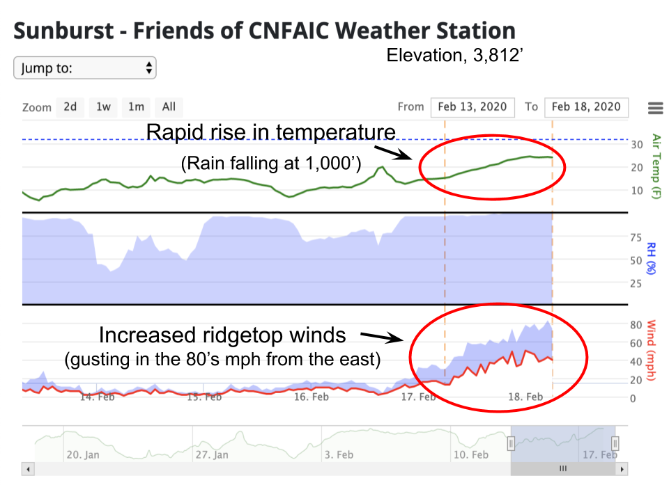
Heavy snowfall, rain, and strong winds have created a HIGH avalanche danger in the mountains surrounding Turnagain Pass, Girdwood Valley, Portage Valley, and areas on the Kenai including Summit Lake and the Seward zone. Dangerous avalanche conditions are expected on all slopes 30 degrees and steeper – including runout zones. Avalanches are expected to release naturally, be easily triggered by people and send debris to valley floors. Travel in avalanche terrain is NOT recommended. Areas with steep slopes above should be avoided, such as the Byron Glacier Trail and the Seattle Ridge Uptrack. Even small terrain features could act as deadly traps.
SUMMIT LAKE TO SEWARD REGION: Expect the avalanche danger to remain elevated due to warm temperatures, strong winds and recent precipitation.
*Roof Avalanches: Warming temperatures and rain could cause roofs to begin to shed their snow. Pay special attention to children, pets and where you park your car.
Increased avalanche danger exists region-wide, outside of our forecast area. Very strong wind was seen overnight and the NWS has issued a winter storm warning for Chugach State Park through tomorrow morning.
Signal Word | Size (D scale) | Simple Descriptor |
Small | 1 | Unlikely to bury a person |
Large | 2 | Can bury a person |
Very Large | 3 | Can destroy a house |
Historic | 4 & 5 | Can destroy part or all of a village |
In the last 24 hours temperatures have increased to above freezing, pushing our snow line to 1300′. The mountains around Girdwood have seen over 1″ of storm water in this time while Turnagain pass is showing 0.3″ of storm water. These numbers could translate to 12-24″ of snow where it’s cold enough to accumulate. We’re expecting up to another 1″ of storm water, which could mean an additional 12-24″ of snow in the Alpine in the coming 24 hour period.
When we add these warm temperatures and precipitation with steady winds ranging from 20-40mph gusting up to 83mph, we’ll have storm snow issues, wet avalanches concerns, and large wind slabs developing.
Natural activity is expected throughout the day with continued weather impacting our region. This includes large natural slab avalanches 2-5’ thick in the alpine and wet avalanches below 2000’ due to heavy rain and above freezing temperatures. Avalanche activity could run the full length of a slope, thus it will be important to stay off any slopes greater than 30 degrees and avoid being near any runout zones today. This set up could be a hazard even in the Tincan Trees where small terrain features could have high consequences. In channeled terrain an avalanche from above could easily entrain wet snow in the lower elevations and run further than expected. This will be especially important in places like Portage Valley, Johnson Pass trail and the flats below Seattle Ridge.
Avoidance of avalanche terrain is the only way to “manage” this problem today. It’s a great day to hit the slopes of Alyeska, or do your taxes!
Signal Word | Size (D scale) | Simple Descriptor |
Small | 1 | Unlikely to bury a person |
Large | 2 | Can bury a person |
Very Large | 3 | Can destroy a house |
Historic | 4 & 5 | Can destroy part or all of a village |
Weak layers of facets and buried surface hoar within the snowpack continue to be a concern throughout the region. With new snow accumulating over the existing snowpack, the region-wide Persistent Slab is transitioning into a Deep Persistent Slab. Significant weak layers now sit at least 3′ deep in the snowpack in many places. Will this new load of snow and rain tip the balance and cause widespread avalanches? Today avalanches occurring in the upper layers of storm snow have the potential to step down and release deeper layers. If this does happen the volume will be large and could run long distances.
Travel in avalanche terrain is not recommended today including being in the runout of a steep slope.
Yesterday: Cloudy skies with 5-10″ of snow accumulation overnight. Winds were easterly at 20-30 mph gusting into the 50s. Temperatures ranged from the low 30°Fs to the high teens. Winds and precipitation intensity increased overnight and temperatures climbed into the 20°Fs and 30°Fs. An inch of storm water (10-12″ of snow) was recorded with rain at sea level and as high as 1000-1300′.
Today: Heavy snow and rain continue today into tomorrow with a snow line forecast at 1300′. Additional snow accumulations ranging from 12-24″ are expected in the Alpine. Winds will remain strong in the morning and slowly diminish later in the day. Temperatures at sea level will hover in the 30°Fs to low 40°Fs during the day and shift into the upper 20°Fs in the evening.
Tomorrow: Tuesdays storm is expected to taper by tomorrow before the next storm picks up Wednesday evening. Temperatures are likely to cool into the 20°Fs with southerly winds ranging from 10-30mph.
PRECIPITATION 24-hour data (6am – 6am)
Temp Avg (F) | Snow (in) | Water (in) | Snow Depth (in) | |
---|---|---|---|---|
Center Ridge (1880′) | 32 | 3 | 0.33 | 64 |
Summit Lake (1400′) | 33 | 2 | 0.3 | 26 |
Alyeska Mid (1700′) | 29 | 8 | 1.1 | 68 |
RIDGETOP 24-hour data (6am – 6am)
Temp Avg (F) | Wind Dir | Wind Avg (mph) | Wind Gust (mph) | |
---|---|---|---|---|
Sunburst (3812′) | 20 | ENE | 37 | 83 |
Seattle Ridge (2400′) | 25 | SE | 18 | 35 |
Date | Region | Location | Observer |
---|---|---|---|
05/22/23 | Turnagain | Avalanche: Tincan | Nick D'Alessio |
05/12/23 | Turnagain | Avalanche: Tincan, Sunburst, Magnum, Cornbiscuit | Heather Thamm |
05/07/23 | Turnagain | Observation: Tincan – Bear Tracks | CNFAIC Staff |
05/05/23 | Turnagain | Observation: Seattle Ridge | AS/ WW Forecaster |
05/02/23 | Turnagain | Observation: Cornbiscuit | Schauer/ Sturgess Forecaster |
05/02/23 | Turnagain | Observation: Seward Hwy Turnagain Pass | Joel Curtis |
04/30/23 | Turnagain | Observation: Magnum | Ayla, Kit Crosby, Barton |
04/29/23 | Turnagain | Observation: Tincan | John Sykes |
04/28/23 | Turnagain | Avalanche: Taylor Pass/Pastoral | Schauer/ Creighton Forecaster |
04/28/23 | Turnagain | Avalanche: Tincan | Andy Moderow |
Status of riding areas across the Chugach NF is managed by the Glacier and Seward Ranger Districts, not avalanche center staff. Riding area information is posted as a public service to our users and updated based on snow depth and snow density to prevent resource damage at trailhead locations. Riding area questions contact: mailroom_r10_chugach@fs.fed.us
Area | Status | Weather & Riding Conditions |
---|---|---|
Glacier District |
Subscribe to Turnagain Pass
Avalanche Forecast by Email
This is a general backcountry avalanche advisory issued for Turnagain Arm with Turnagain Pass as the core advisory area. This advisory does not apply to highways, railroads or operating ski areas.