Turnagain Pass RSS

Archives
ARCHIVED - Forecasts expire after 24 hours.
Issued
Wed, February 19th, 2020 - 7:00AM
Expires
Thu, February 20th, 2020 - 7:00AM
Forecaster
Aleph Johnston-Bloom
High Avalanche Danger
Travel in avalanche terrain is not recommended. Avoid being on or beneath all steep slopes.
Avalanche risk The Bottom Line

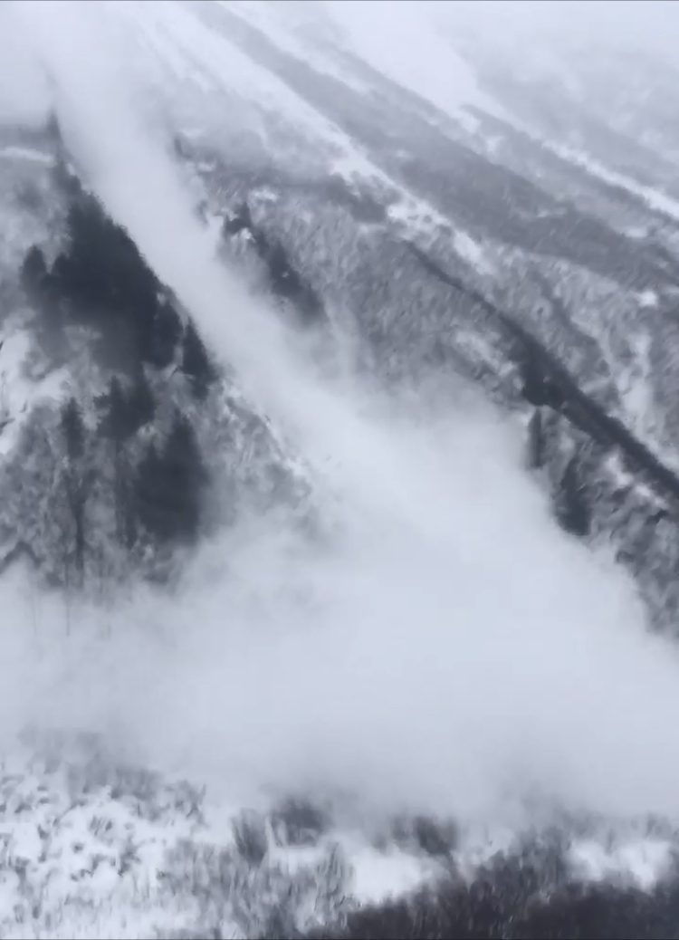
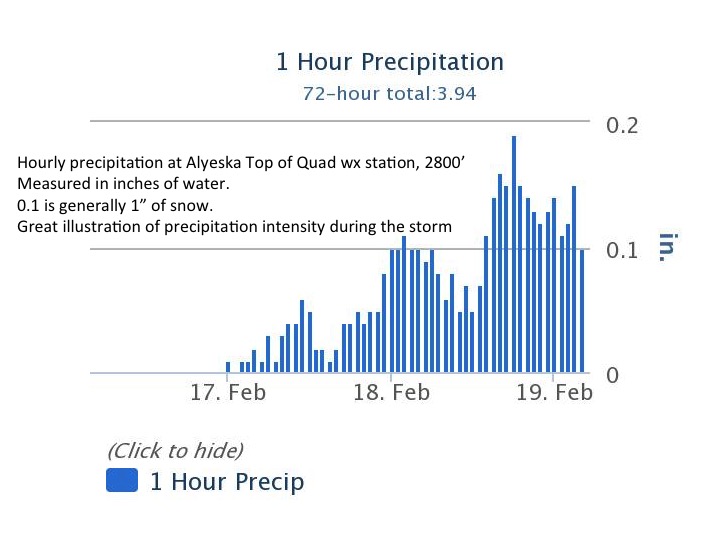
The avalanche danger is HIGH for a second day in a row due to heavy snowfall and strong winds in the mountains surrounding Turnagain Pass, Girdwood Valley, Portage Valley, and areas on the Kenai including Summit Lake and the Seward/Lost Lake zone. Dangerous avalanche conditions are expected on all slopes 30 degrees and steeper – including runout zones. Avalanches could release naturally and human triggered avalanches are very likely.  Travel in avalanche terrain is NOT recommended. Areas with steep slopes above should be avoided, such as the Byron Glacier Trail and the Seattle Ridge uptrack. Even small terrain features could act as deadly traps.

REGION-WIDE: High avalanche danger extends north from our forecast area including Chugach State Park to Hatcher Pass, where an avalanche warning is in effect until 12 pm today.  Travel in avalanche terrain is not recommended.

*Roof Avalanches:  New snow/rain load with warming temperatures could cause roofs to continue to shed their snow. Pay special attention to children, pets and where you park your car.

Special Announcements

From Alaska DOT & PF: There will be intermittent traffic delays today, February 19, 2020 on the Seward Highway for avalanche hazard reduction work. Bird Flats to Portage. Motorists should expect delays of up to 45 minutes between 10:00 AM-3:00 PM. Updates will be posted on the 511 system. https://511.alaska.gov/

Wed, February 19th, 2020
Alpine
Above 2,500'
4 - High
Avalanche risk
Treeline
1,000'-2,500'
4 - High
Avalanche risk
Below Treeline
Below 1,000'
4 - High
Avalanche risk
0 - No Rating
1 - Low
2 - Moderate
3 - Considerable
4 - High
5 - Extreme
Avalanche risk Avalanche risk Avalanche risk Avalanche risk Avalanche risk
Travel Advice Generally safe avalanche conditions. Watch for unstable snow on isolated terrain features. Heightened avalanche conditions on specific terrain features. Evaluate snow and terrain carefully; identify features of concern. Dangerous avalanche conditions. Careful snowpack evaluation, cautious route-finding, and conservative decision-making essential. Very dangerous avalanche conditions. Travel in avalanche terrain not recommended. Extraordinarily dangerous avalanche conditions. Avoid all avalanche terrain.
Likelihood of Avalanches Natural and human-triggered avalanches unlikely. Natural avalanches unlikely; human-triggered avalanches possible. Natural avalanches possible; human-triggered avalanches likely. Natural avalanches likely; human-triggered avalanches very likely. Natural and human-triggered avalanches certain.
Avalanche Size and Distribution Small avalanches in isolated areas or extreme terrain. Small avalanches in specific areas; or large avalanches in isolated areas. Small avalanches in many areas; or large avalanches in specific areas; or very large avalanches in isolated areas. Large avalanches in many areas; or very large avalanches in specific areas. Very large avalanches in many areas.
Recent Avalanches

Crow Creek natural avalanche in motion at 9:15 am. 2.18.20

An observer yesterday witnessed an avalanche in motion up Crow Creek road at 9:15 am. There were also naturals reported in Portage later in the day. Overall visibility during the day was poor and not conducive to observations. We expect more natural avalanche activity happened throughout the day and during the peak intensity of the storm overnight.

Avalanche Problem 1
  • Storm Slabs
    Storm Slabs
  • Certain
    Very Likely
    Likely
    Possible
    Unlikely
    Likelihood
  • Historic (D4-5)
    Very Large (D3)
    Large (D2)
    Small (D1)
    Size
Storm Slabs
Storm Slab avalanches are the release of a cohesive layer (a slab) of new snow that breaks within new snow or on the old snow surface. Storm-slabs typically last between a few hours and few days (following snowfall). Storm-slabs that form over a persistent weak layer (surface hoar, depth hoar, or near-surface facets) may be termed Persistent Slabs or may develop into Persistent Slabs.

Likelihood of Avalanches
Terms such as "unlikely", "likely", and "certain" are used to define the scale, with the chance of triggering or observing avalanches increasing as we move up the scale. For our purposes, "Unlikely" means that few avalanches could be triggered in avalanche terrain and natural avalanches are not expected. "Certain" means that humans will be able to trigger avalanches on many slopes, and natural avalanches are expected.

Size of Avalanches
Avalanche size is defined by the largest potential avalanche, or expected range of sizes related to the problem in question. Assigned size is a qualitative estimate based on the destructive classification system and requires specialists to estimate the harm avalanches may cause to hypothetical objects located in the avalanche track (AAA 2016, CAA 2014). Under this schema, "Small" avalanches are not large enough to bury humans and are relatively harmless unless they carry people over cliffs or through trees or rocks. Moving up the scale, avalanches become "Large" enough to bury, injure, or kill people. "Very Large" avalanches may bury or destroy vehicles or houses, and "Historic" avalanches are massive events capable of altering the landscape.

Signal Word Size (D scale) Simple Descriptor
Small 1 Unlikely to bury a person
Large 2 Can bury a person
Very Large 3 Can destroy a house
Historic 4 & 5 Can destroy part or all of a village
More info at Avalanche.org

Travel in avalanche terrain is not recommended again today. The mountains have received a significant load and there are buried weak layers. Yesterday the storm delivered as promised, with close to 3′ of snow falling at upper elevations in Girdwood and 1-2′ of snow at Turnagain Pass. This is on top of the snow/rain that fell Monday. Yesterday rain/snowline started around 1300′ and mid afternoon dropped down to approximately 200′ and then close to sea level overnight. Snow was falling around an inch per hour for over 14 hours. Winds were easterly 20-30 mph with gusts into the 60s and 70s.  There were natural avalanches observed yesterday and there is the potential for more today. Human triggered avalanches are very likely today.  After all the rapid loading there are a variety of storm related avalanche issues expected: storm slabs, wind slabs, large tender cornices and loose snow avalanches. Additionally, as highlighted below in Avalanche Problem 2 there are deep slab concerns. Avalanches breaking in the recent snow may step down to the old weak layers of snow. Another storm is forecast to move later today. All this information should be making the decision easy.  Don’t go to the mountains today! The snowpack needs time to adjust. Be patient!

Avalanche Problem 2
  • Deep Persistent Slabs
    Deep Persistent Slabs
  • Certain
    Very Likely
    Likely
    Possible
    Unlikely
    Likelihood
  • Historic (D4-5)
    Very Large (D3)
    Large (D2)
    Small (D1)
    Size
Deep Persistent Slabs
Deep Persistent Slab avalanches are the release of a thick cohesive layer of hard snow (a slab), when the bond breaks between the slab and an underlying persistent weak layer deep in the snowpack. The most common persistent weak layers involved in deep, persistent slabs are depth hoar or facets surrounding a deeply buried crust. Deep Persistent Slabs are typically hard to trigger, are very destructive and dangerous due to the large mass of snow involved, and can persist for months once developed. They are often triggered from areas where the snow is shallow and weak, and are particularly difficult to forecast for and manage.

Likelihood of Avalanches
Terms such as "unlikely", "likely", and "certain" are used to define the scale, with the chance of triggering or observing avalanches increasing as we move up the scale. For our purposes, "Unlikely" means that few avalanches could be triggered in avalanche terrain and natural avalanches are not expected. "Certain" means that humans will be able to trigger avalanches on many slopes, and natural avalanches are expected.

Size of Avalanches
Avalanche size is defined by the largest potential avalanche, or expected range of sizes related to the problem in question. Assigned size is a qualitative estimate based on the destructive classification system and requires specialists to estimate the harm avalanches may cause to hypothetical objects located in the avalanche track (AAA 2016, CAA 2014). Under this schema, "Small" avalanches are not large enough to bury humans and are relatively harmless unless they carry people over cliffs or through trees or rocks. Moving up the scale, avalanches become "Large" enough to bury, injure, or kill people. "Very Large" avalanches may bury or destroy vehicles or houses, and "Historic" avalanches are massive events capable of altering the landscape.

Signal Word Size (D scale) Simple Descriptor
Small 1 Unlikely to bury a person
Large 2 Can bury a person
Very Large 3 Can destroy a house
Historic 4 & 5 Can destroy part or all of a village
More info at Avalanche.org

With the storm adding 2-4″ of water weight/2-4+ feet of snow combined with strong winds, the weak faceted January snow is now buried 3-6+ feet deep. In addition to the concern of storm related avalanches, there is the possibility that avalanches will step down to the weak snow and result in very large, destructive avalanches that could run far into the terrain below. This is a big reason travel in avalanche terrain is not recommended today, including being in the runout of steep slopes.

Weather
Wed, February 19th, 2020

Yesterday: Skies were obscured and precipitation fell throughout the day, increasing intensity overnight. Rain/snowline started around 1300′ and mid afternoon dropped down to approximately 200′ and then close to sea level overnight. Upper elevation Girdwood was favored receiving close to 3″ of water/3′ of snow. Turnagain picked up over 1″of water and over a 1′ of snow.  Temperatures ranged from the mid 20°Fs to the high 30°Fs. Winds were easterly 20-30 mph with gusts into the 60s and 70s.

Today: Snow will continue this morning tapering off to light snow showers by mid-day, 1-5″ possible at sea level. Temperatures will be in the 20°Fs to low 30°Fs. Wind will be southerly 5-15 mph with gusts into the 30s. The next storm will move into the region tonight with snow to sea level and close to another inch of water/foot of snow forecast to fall overnight. Snow could be heavy at times. Easterly winds will ramp back up blowing 25-35 mph gusting into the 60s. Temperatures will be in the 20Fs and low 30Fs.

Tomorrow: The storm continues with snow falling throughout the day with the intensity tapering in the afternoon. Temperatures will be in the 20°Fs and low 30°Fs and rise later in the day with the potential for rain at sea level and then cool a bit overnight. Easterly winds remain strong and gusty in the morning and ease off later in the day becoming mostly calm overnight. Cloudy skies and snow continue into Friday as moisture lingers over the area and cooler air moves into the region.

PRECIPITATION 24-hour data (6am – 6am)

Temp Avg (F) Snow (in) Water (in) Snow Depth (in)
Center Ridge (1880′) 31 15 1.2 80
Summit Lake (1400′) 31 5 0.5 30
Alyeska Mid (1700′) 31 23 2.16 84

RIDGETOP 24-hour data (6am – 6am)

Temp Avg (F) Wind Dir Wind Avg (mph) Wind Gust (mph)
Sunburst (3812′) 22 NE 25 74
Seattle Ridge (2400′) 26 SE* 19* 42*

*Data incomplete. Wind sensor stopped reporting at 12 pm yesterday.

Observations
Recent Observations for Turnagain Pass
Date Region Location
04/16/24 Turnagain Observation: Cornbiscuit
04/15/24 Turnagain Observation: Taylor Pass
04/15/24 Turnagain Observation: Seward Highway – Tern Lake to Portage
04/14/24 Turnagain Observation: Sunburst
04/14/24 Turnagain Observation: Turnagain Pass Snomo
04/13/24 Turnagain Observation: Spokane Creek
04/11/24 Turnagain Observation: Tincan
04/10/24 Turnagain Avalanche: Seattle Ridge
04/10/24 Turnagain Observation: Cornbiscuit South Face
04/10/24 Turnagain Avalanche: Tincan
Riding Areas

The riding areas page has moved. Please click here & update your bookmarks.


Subscribe to Turnagain Pass
Avalanche Forecast by Email

This is a general backcountry avalanche advisory issued for Turnagain Arm with Turnagain Pass as the core advisory area. This advisory does not apply to highways, railroads or operating ski areas.