Turnagain Pass RSS

Archives
ARCHIVED - Forecasts expire after 24 hours.
Issued
Mon, February 17th, 2020 - 7:00AM
Expires
Tue, February 18th, 2020 - 7:00AM
Forecaster
Aleph Johnston-Bloom
Avalanche risk The Bottom Line

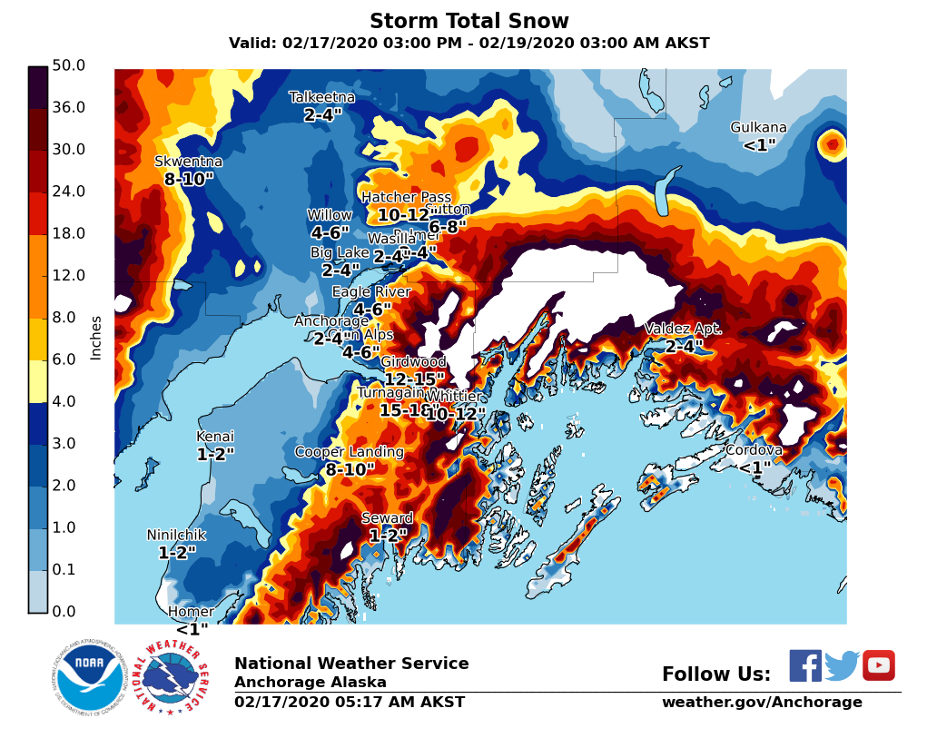
The avalanche danger will rise to CONSIDERABLE  as the region is impacted by a storm today and tonight. Strong winds, rising temperatures and new snow will create wind and storm slabs and tender cornices. Human triggered avalanches will become likely and naturals will be possible. In addition, weak snow deeper in the snowpack has the potential to become overloaded, resulting in very large, dangerous avalanches. Pay attention to changing conditions and choose terrain carefully.

*Roof Avalanches:  Warming temperatures and rain could cause roofs to begin to shed their snow. Pay attention to children, pets and where you park your car.

UPDATE: 8:30 am. With information coming in after the forecast was published, we added a skier triggered avalanche on Sunburst yesterday to recent avalanches.

Mon, February 17th, 2020
Alpine
Above 2,500'
3 - Considerable
Avalanche risk
Treeline
1,000'-2,500'
3 - Considerable
Avalanche risk
Below Treeline
Below 1,000'
3 - Considerable
Avalanche risk
0 - No Rating
1 - Low
2 - Moderate
3 - Considerable
4 - High
5 - Extreme
Avalanche risk Avalanche risk Avalanche risk Avalanche risk Avalanche risk
Travel Advice Generally safe avalanche conditions. Watch for unstable snow on isolated terrain features. Heightened avalanche conditions on specific terrain features. Evaluate snow and terrain carefully; identify features of concern. Dangerous avalanche conditions. Careful snowpack evaluation, cautious route-finding, and conservative decision-making essential. Very dangerous avalanche conditions. Travel in avalanche terrain not recommended. Extraordinarily dangerous avalanche conditions. Avoid all avalanche terrain.
Likelihood of Avalanches Natural and human-triggered avalanches unlikely. Natural avalanches unlikely; human-triggered avalanches possible. Natural avalanches possible; human-triggered avalanches likely. Natural avalanches likely; human-triggered avalanches very likely. Natural and human-triggered avalanches certain.
Avalanche Size and Distribution Small avalanches in isolated areas or extreme terrain. Small avalanches in specific areas; or large avalanches in isolated areas. Small avalanches in many areas; or large avalanches in specific areas; or very large avalanches in isolated areas. Large avalanches in many areas; or very large avalanches in specific areas. Very large avalanches in many areas.
Recent Avalanches

There was a skier triggered avalanche observed on Sunburst yesterday. Information is not from party involved but from another group skiing in the area. “A skier then skied down the small bowl just before (west) of where we skied. We didn’t see the slide. But looked up to see him on the bed surface. The crown broke above him and it appeared he was able to self arrest in the bed surface.”

Skier triggered avalanche on Sunburst. 2.16.20.

Avalanche Problem 1
  • Storm Slabs
    Storm Slabs
  • Certain
    Very Likely
    Likely
    Possible
    Unlikely
    Likelihood
  • Historic (D4-5)
    Very Large (D3)
    Large (D2)
    Small (D1)
    Size
Storm Slabs
Storm Slab avalanches are the release of a cohesive layer (a slab) of new snow that breaks within new snow or on the old snow surface. Storm-slabs typically last between a few hours and few days (following snowfall). Storm-slabs that form over a persistent weak layer (surface hoar, depth hoar, or near-surface facets) may be termed Persistent Slabs or may develop into Persistent Slabs.

Likelihood of Avalanches
Terms such as "unlikely", "likely", and "certain" are used to define the scale, with the chance of triggering or observing avalanches increasing as we move up the scale. For our purposes, "Unlikely" means that few avalanches could be triggered in avalanche terrain and natural avalanches are not expected. "Certain" means that humans will be able to trigger avalanches on many slopes, and natural avalanches are expected.

Size of Avalanches
Avalanche size is defined by the largest potential avalanche, or expected range of sizes related to the problem in question. Assigned size is a qualitative estimate based on the destructive classification system and requires specialists to estimate the harm avalanches may cause to hypothetical objects located in the avalanche track (AAA 2016, CAA 2014). Under this schema, "Small" avalanches are not large enough to bury humans and are relatively harmless unless they carry people over cliffs or through trees or rocks. Moving up the scale, avalanches become "Large" enough to bury, injure, or kill people. "Very Large" avalanches may bury or destroy vehicles or houses, and "Historic" avalanches are massive events capable of altering the landscape.

Signal Word Size (D scale) Simple Descriptor
Small 1 Unlikely to bury a person
Large 2 Can bury a person
Very Large 3 Can destroy a house
Historic 4 & 5 Can destroy part or all of a village
More info at Avalanche.org

After a few sunny days the next storm is upon us. A couple of inches of snow have fallen, winds are ramping up and temperatures have risen with some weather stations seeing as much as a 30 degree increase. Today that means avalanche danger will be on the rise with variety of storm related avalanche issues. There is plenty of soft snow available for transport and with strong winds in the forecast today into tomorrow, expect wind slab formation on steep leeward slopes and in gully features. As more new snow accumulates with rising temperatures storm slabs will also form in areas out of the wind. Don’t forget the buried weak layers! These could get overloaded and we may see very large avalanches as this storm progresses (see more below in Avalanche Problem 2). If you head out into the mountains today watch for blowing snow, drifting and cracking. As the storm intensifies natural avalanches will become possible. Think about what terrain is above you and avoid avalanche runout zones and terrain traps.

Expected storm total snow from this afternoon to Wednesday morning from the National Weather Service.

Cornices:  With blowing snow and increasing temperatures cornices will grow and could be tender. Natural cornice falls have the potential to trigger avalanches on slopes below.

Loose snow avalanches: At upper elevations loose dry snow avalanches/sluffs are possible in steep protected terrain. On low elevation slopes with heavy wet snow and/or rain possible, watch for wet loose snow avalanches.

Avalanche Problem 2
  • Persistent Slabs
    Persistent Slabs
  • Certain
    Very Likely
    Likely
    Possible
    Unlikely
    Likelihood
  • Historic (D4-5)
    Very Large (D3)
    Large (D2)
    Small (D1)
    Size
Persistent Slabs
Persistent Slab avalanches are the release of a cohesive layer of snow (a slab) in the middle to upper snowpack, when the bond to an underlying persistent weak layer breaks. Persistent layers include: surface hoar, depth hoar, near-surface facets, or faceted snow. Persistent weak layers can continue to produce avalanches for days, weeks or even months, making them especially dangerous and tricky. As additional snow and wind events build a thicker slab on top of the persistent weak layer, this avalanche problem may develop into a Deep Persistent Slab.

Likelihood of Avalanches
Terms such as "unlikely", "likely", and "certain" are used to define the scale, with the chance of triggering or observing avalanches increasing as we move up the scale. For our purposes, "Unlikely" means that few avalanches could be triggered in avalanche terrain and natural avalanches are not expected. "Certain" means that humans will be able to trigger avalanches on many slopes, and natural avalanches are expected.

Size of Avalanches
Avalanche size is defined by the largest potential avalanche, or expected range of sizes related to the problem in question. Assigned size is a qualitative estimate based on the destructive classification system and requires specialists to estimate the harm avalanches may cause to hypothetical objects located in the avalanche track (AAA 2016, CAA 2014). Under this schema, "Small" avalanches are not large enough to bury humans and are relatively harmless unless they carry people over cliffs or through trees or rocks. Moving up the scale, avalanches become "Large" enough to bury, injure, or kill people. "Very Large" avalanches may bury or destroy vehicles or houses, and "Historic" avalanches are massive events capable of altering the landscape.

Signal Word Size (D scale) Simple Descriptor
Small 1 Unlikely to bury a person
Large 2 Can bury a person
Very Large 3 Can destroy a house
Historic 4 & 5 Can destroy part or all of a village
More info at Avalanche.org

For weeks we have been talking about a couple of layers of weak faceted snow and a crust buried in the snowpack. We have seen very large natural and human triggered avalanches fail on these layers and there was a skier triggered avalanche on Sunburst yesterday. We suspect this also failed on facets. Now the concern is that the incoming storm will eventually overload the existing snowpack and result in another widespread avalanche cycle. Today might not be the natural avalanche tipping point but you could still be the trigger if you find the wrong spot. With poor visibility it will be important to choose terrain carefully and avoid runout areas. As the storm intensifies tonight into tomorrow, the potential for avalanches to fail on these deeper layers will increase! We are in an active weather pattern all week.  Stay tuned and don’t forget the lurking weak layers!

Remember weak snow is a few feet deep and more snow/wind/rain? could add slab and stress! 2.16.20. 

Weak faceted (sugar) snow buried 2-4+ feet down… a.k.a bad news in the basement! 2.16.20. Photo: Allen Dahl

Weather
Mon, February 17th, 2020

Yesterday: Skies were mostly clear and sunny with clouds moving in late in the day. Temperatures were in the single digits and teens to low 20°Fs. Winds were mostly calm. Overnight skies became cloudy and temperatures climbed with upper elevations in the teens and mid elevations in the mid to high 20°Fs and sea level weather stations hitting 30°F. An inch of snow fell overnight and easterly winds were in the teens gusting into the 30s.

Today: Cloudy skies and snow with 5-10″ possible and easterly winds 20-30 mph gusting into the 50s. Temperatures will be range with elevation from the low 30°Fs to the high teens. Winds and precipitation intensity will increase overnight and temperatures will climb into the high 20°Fs and 30°Fs. An inch of water/10-15″ of snow is forecasted with rain possible at sea level and maybe as high as 1000′. Precipitation intensity could be heavy at times.

Tomorrow: Heavy snow and rain likely. Winds will remain strong in the morning and slowly diminish later in the day. Temperatures will be in the high 20°Fs to low 40°Fs. Temperatures slightly cool overnight with precipitation shifting to mostly snow. Wednesday precipitation eases off and then another system impacts the area Thursday.

PRECIPITATION 24-hour data (6am – 6am)

Temp Avg (F) Snow (in) Water (in) Snow Depth (in)
Center Ridge (1880′) 17 1 0.1 63
Summit Lake (1400′) 12 1 0.1 26
Alyeska Mid (1700′) 16 2 0.1 60

RIDGETOP 24-hour data (6am – 6am)

Temp Avg (F) Wind Dir Wind Avg (mph) Wind Gust (mph)
Sunburst (3812′) 14 NE 9 35
Seattle Ridge (2400′) 16 SE 7 24
Observations
Recent Observations for Turnagain Pass
Date Region Location
03/27/24 Turnagain Observation: Tincan Trees
03/26/24 Turnagain Observation: Cornbiscuit
03/25/24 Turnagain Observation: Tincan
03/22/24 Turnagain Avalanche: Magnum Northwest Aspect
03/21/24 Turnagain Observation: Sunburst
03/21/24 Turnagain Observation: Tincan Proper North Aspect
03/20/24 Turnagain Avalanche: Seattle Creek Drainage
03/19/24 Turnagain Observation: Tincan CFR
03/18/24 Turnagain Avalanche: Tincan – Eddies – Seattle Ridge
03/18/24 Turnagain Observation: Tincan
Riding Areas

The riding areas page has moved. Please click here & update your bookmarks.


Subscribe to Turnagain Pass
Avalanche Forecast by Email

This is a general backcountry avalanche advisory issued for Turnagain Arm with Turnagain Pass as the core advisory area. This advisory does not apply to highways, railroads or operating ski areas.