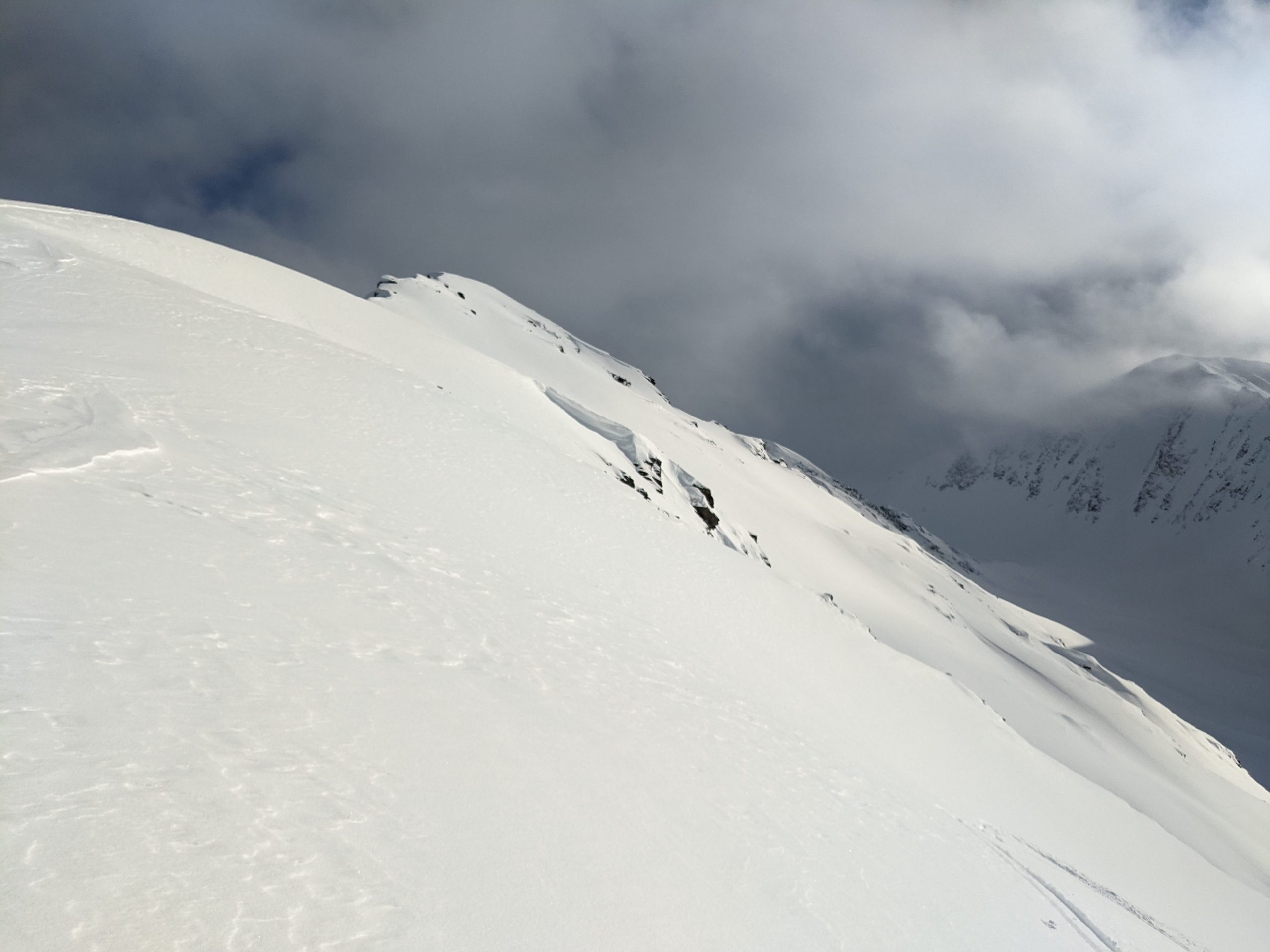
Turnagain Pass Avalanche Forecast
|
![]() ![]() |
The avalanche danger is MODERATE above 2500′ today. Lingering wind slabs up to 1′ deep are possible for a person to trigger, especially in steeper terrain along ridgelines. Another storm is approaching the area this afternoon which will bring increased winds and cloud cover and 4-8″ of snowfall by tomorrow morning. The new snow and winds will create fresh wind slabs that will be more reactive to human triggers and will increase the avalanche danger. Below 2500′ the avalanche danger is LOW.
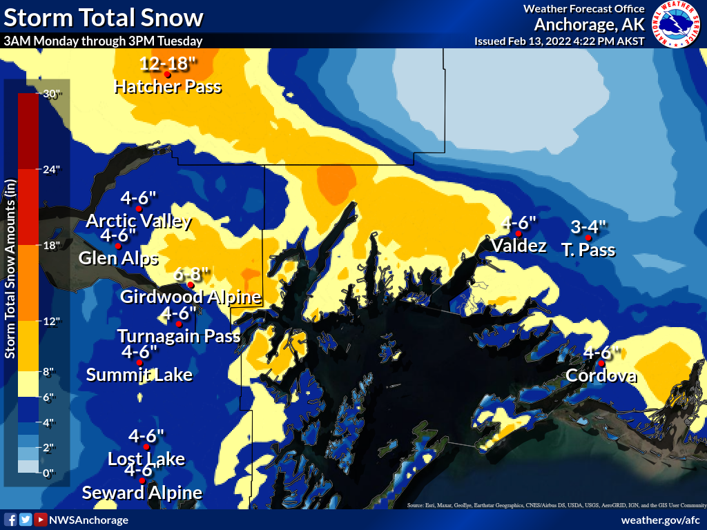
Signal Word | Size (D scale) | Simple Descriptor |
Small | 1 | Unlikely to bury a person |
Large | 2 | Can bury a person |
Very Large | 3 | Can destroy a house |
Historic | 4 & 5 | Can destroy part or all of a village |
The next storm system is approaching our area today and should arrive in the late afternoon or early evening, bringing increasing cloud cover, winds, and snowfall. This will build fresh wind slabs up to 1′ deep and make human triggered avalanches more likely. Until then the mountains have been fairly quiet over the past couple days, with light to moderate winds and broken cloud cover. A few avalanches have been observed in the forecast area but they have been isolated to areas with suspected lingering weak layers of decomposing new snow underneath wind slabs and areas with higher than average winds, like along Turnagain Arm. It will still be possible to trigger a lingering wind slab up to 1′ deep in these areas, especially in steeper terrain, and we recommend evaluating wind loaded features before entering avalanche terrain.
Loose Avalanches: Dry loose avalanches (sluffs) were observed in steeper terrain yesterday and are expected again today. The soft snow on the surface is only a few inches deep in most areas so these sluffs are fairly low volume. In addition, the snow surface on S face of Cornbiscuit was getting heated up by the sun yesterday and causing roller balls to run from the ridgetop all the way to the valley floor.
Snowfall totals for Monday night into Tuesday morning storm system. Hatcher Pass is the big winner with 12-18″, Girdwood gets a silver with 6-8″, and Turnagain and Summit tie for bronze with 4-6″. Graphic courtesy of NWS Anchorage 2.13.22
Wind effect along Cornbiscuit ridgeline. The sun was strong enough to create a moist snow surface and send rollerballs all the way down to the valley bottom on S face of Cornbiscuit. Photo 2.13.22
An old weak layer of buried facets from November is still lurking in the snowpack and has shown signs of reactivating in Summit Lake where there is a shallow overall snowpack depth (details here). Summit Lake is outside our forecast area, but some of the southern portions of the forecast area are in a transitional zone between the deeper snowpack of Turnagain Pass and the shallower snowpack of Summit Lake. Similarly, the Crow Pass area is on the far northern end of our forecast area and is a transitional zone between the deeper snowpack of Girdwood and the shallower snowpack of the Chugach Front Range. We have also found similar shallow and weak snowpack structure in wind scoured areas of Turnagain Pass, although the distribution of the shallow snowpack is less widespread (example here). In these shallow snowpack areas the November facets are only buried a few feet deep and remain weak and have shown potential to propagate in snow pit tests. Triggering an avalanche on this layer remains unlikely within our forecast area, however the potential for this layer to create large avalanches has us keeping close track of its distribution and watching for any new avalanches that are able to release or step down onto these old facets.
Snowpack in a wind scoured area on N side of Magnum that has weak structure due to buried November facets below the New Years Crust. Photo Andy Moderow 2.13.22
Yesterday: Calm winds, variable cloud cover, and an occasional snow, rain, or hail shower with no meaningful accumulation. In Turnagain Pass the visibility was pretty good in the alpine with occasional periods of flat light. When the sun poked through the clouds it felt warm and was affecting snow surface conditions on steep south facing terrain.
Today: Today will start out similar to yesterday with calm winds and low cloud cover until the next storm front arrives in the afternoon, bringing snowfall and increased S and SE winds. Temperatures should be in the 20s today but snow line could rise up to 1000′ early Tuesday morning during the end of the precipitation. Snowfall totals will be 1-3″ this evening and 3-6″ overnight tonight. Higher snowfall amounts are expected for Hatcher Pass.
Tomorrow: Snowfall should taper off by the morning tomorrow with the potential for improved visibility during the day. Storm totals are expected to be 6-8″ in Girdwood and 4-6″ for Turnagain Pass and Summit Lake. Winds will increase to 5-25 mph out of the W on Tuesday and temperatures will be in the 30s at lower elevations and 20s at upper elevations.
PRECIPITATION 24-hour data (6am – 6am)
Temp Avg (F) | Snow (in) | Water (in) | Snow Depth (in) | |
---|---|---|---|---|
Center Ridge (1880′) | 27 | 0 | 0 | 90 |
Summit Lake (1400′) | 20 | 0 | 0 | 38 |
Alyeska Mid (1700′) | 28 | tr | 0.04 | N/A |
RIDGETOP 24-hour data (6am – 6am)
Temp Avg (F) | Wind Dir | Wind Avg (mph) | Wind Gust (mph) | |
---|---|---|---|---|
Sunburst (3812′) | 19 | var* | 5 | 21 |
Seattle Ridge (2400′) | 22 | var* | 3 | 10 |
*variable wind direction, E in the morning, then W in the afternoon, then N in the evening and overnight.
Date | Region | Location | Observer |
---|---|---|---|
05/22/23 | Turnagain | Avalanche: Tincan | Nick D'Alessio |
05/12/23 | Turnagain | Avalanche: Tincan, Sunburst, Magnum, Cornbiscuit | Heather Thamm |
05/07/23 | Turnagain | Observation: Tincan – Bear Tracks | CNFAIC Staff |
05/05/23 | Turnagain | Observation: Seattle Ridge | AS/ WW Forecaster |
05/02/23 | Turnagain | Observation: Cornbiscuit | Schauer/ Sturgess Forecaster |
05/02/23 | Turnagain | Observation: Seward Hwy Turnagain Pass | Joel Curtis |
04/30/23 | Turnagain | Observation: Magnum | Ayla, Kit Crosby, Barton |
04/29/23 | Turnagain | Observation: Tincan | John Sykes |
04/28/23 | Turnagain | Avalanche: Taylor Pass/Pastoral | Schauer/ Creighton Forecaster |
04/28/23 | Turnagain | Avalanche: Tincan | Andy Moderow |
Status of riding areas across the Chugach NF is managed by the Glacier and Seward Ranger Districts, not avalanche center staff. Riding area information is posted as a public service to our users and updated based on snow depth and snow density to prevent resource damage at trailhead locations. Riding area questions contact: mailroom_r10_chugach@fs.fed.us
Area | Status | Weather & Riding Conditions |
---|---|---|
Glacier District |
Subscribe to Turnagain Pass
Avalanche Forecast by Email
This is a general backcountry avalanche advisory issued for Turnagain Arm with Turnagain Pass as the core advisory area. This advisory does not apply to highways, railroads or operating ski areas.