Turnagain Pass Avalanche Forecast RSS

Archives
ARCHIVED FORECAST - All forecasts expire after 24 hours from the posting date/time.
Issued
Thu, February 13th, 2020 - 7:00AM
Expires
Fri, February 14th, 2020 - 7:00AM
Forecaster
Wendy Wagner
Avalanche risk The Bottom Line

The avalanche danger is CONSIDERABLE above 1,000′. Triggering a large and dangerous slab avalanche, 2-4′ thick that fails in buried weak snow, remains a primary concern and extra caution is advised for mountain travel. Wind slabs, storm slabs, sluffs and cornice falls, all associated with yesterday’s 10-18″ of new snow, will also be possible to trigger. These relatively smaller avalanches could step down and trigger a much larger avalanche.

UPDATE 12:19pm:  Strong northerly winds are impacting many areas, including Girdwood, Portage Valley, Summit Lake and other zones on the Kenai south of the forecast zone. Natural wind slab avalanches are possible region-wide. The danger still remains CONSIDERABLE.

Special Announcements

TOMORROW NIGHT!!!
Don’t miss the 6th Annual Snowball! Friday – February 14, 2020. 7-11 pm at 49th State Brewing Co. in Anchorage. I Like Robots will be rockin’ our favorite 80’s tunes! Awesome silent auction and costume contest, so break out your best 80’s fashion and snow gear! $35 tickets on sale HERE. Proceeds support Friends of the Chugach Avalanche Center and the Alaska Avalanche School.

Thanks to our sponsors!
Thu, February 13th, 2020
Alpine
Above 2,500'
Considerable (3)
Avalanche risk
Treeline
1,000'-2,500'
Considerable (3)
Avalanche risk
Below Treeline
Below 1,000'
Moderate (2)
Avalanche risk
Alpine
Above 2,500'
Avalanche risk
Considerable (3)
Treeline
1,000'-2,500'
Avalanche risk
Considerable (3)
Below Treeline
Below 1,000'
Avalanche risk
Moderate (2)
Danger Scale:
No Rating (0)
Low (1)
Moderate (2)
Considerable (3)
High (4)
Extreme (5)
Avalanche Problem 1
  • Persistent Slabs
    Persistent Slabs
  • Almost Certain
    Very Likely
    Likely
    Possible
    Unlikely
    Likelihood
  • Historic (D4-5)
    Very Large (D3)
    Large (D2)
    Small (D1)
    Size
Persistent Slabs
Persistent Slab avalanches are the release of a cohesive layer of snow (a slab) in the middle to upper snowpack, when the bond to an underlying persistent weak layer breaks. Persistent layers include: surface hoar, depth hoar, near-surface facets, or faceted snow. Persistent weak layers can continue to produce avalanches for days, weeks or even months, making them especially dangerous and tricky. As additional snow and wind events build a thicker slab on top of the persistent weak layer, this avalanche problem may develop into a Deep Persistent Slab.

Likelihood of Avalanches
Terms such as "unlikely", "likely", and "certain" are used to define the scale, with the chance of triggering or observing avalanches increasing as we move up the scale. For our purposes, "Unlikely" means that few avalanches could be triggered in avalanche terrain and natural avalanches are not expected. "Certain" means that humans will be able to trigger avalanches on many slopes, and natural avalanches are expected.

Size of Avalanches
Avalanche size is defined by the largest potential avalanche, or expected range of sizes related to the problem in question. Assigned size is a qualitative estimate based on the destructive classification system and requires specialists to estimate the harm avalanches may cause to hypothetical objects located in the avalanche track (AAA 2016, CAA 2014). Under this schema, "Small" avalanches are not large enough to bury humans and are relatively harmless unless they carry people over cliffs or through trees or rocks. Moving up the scale, avalanches become "Large" enough to bury, injure, or kill people. "Very Large" avalanches may bury or destroy vehicles or houses, and "Historic" avalanches are massive events capable of altering the landscape.

Signal Word Size (D scale) Simple Descriptor
Small 1 Unlikely to bury a person
Large 2 Can bury a person
Very Large 3 Can destroy a house
Historic 4 & 5 Can destroy part or all of a village
More info at Avalanche.org

Despite the clearing skies, mild weather and fresh layer of new snow, approaching the mountains with extra caution is advised. Just before yesterday’s storm (more on that below), several slab avalanches were triggered that all failed in weak buried faceted snow 2-3′ below the surface. Some of these were very large and one, outside of our forecast zone sadly resulted in a fatality. These buried weak layers are now 2.5-4′ below the surface, depending on how much snow has fallen in what area. One thing we know for certain is these weak layers are a region-wide problem. How large the slab is above them and how likely the slab is for us to trigger, is the big question. The size of a potential avalanche is too big and the consequences are too high to forget we have these dragons lurking below. Hence, we need to be on our guard during this clear sky period regardless of where we travel. Sticking to lower angle terrain with nothing steep above you is a good way to manage this issue and have a safe day out in the backcountry.

Things to keep in mind with this Persistent Slab problem:

  • Just because the surface snow ‘seems’ or ‘feels’ solid doesn’t mean the buried weak layers are
  • No signs of instability may be present before a slope releases
  • It could be the 2nd or 10th person on a slope before someone finds the trigger spot
  • Large slabs could be triggered remotely: from the bottom of the slope, the top or to the side of the slope.

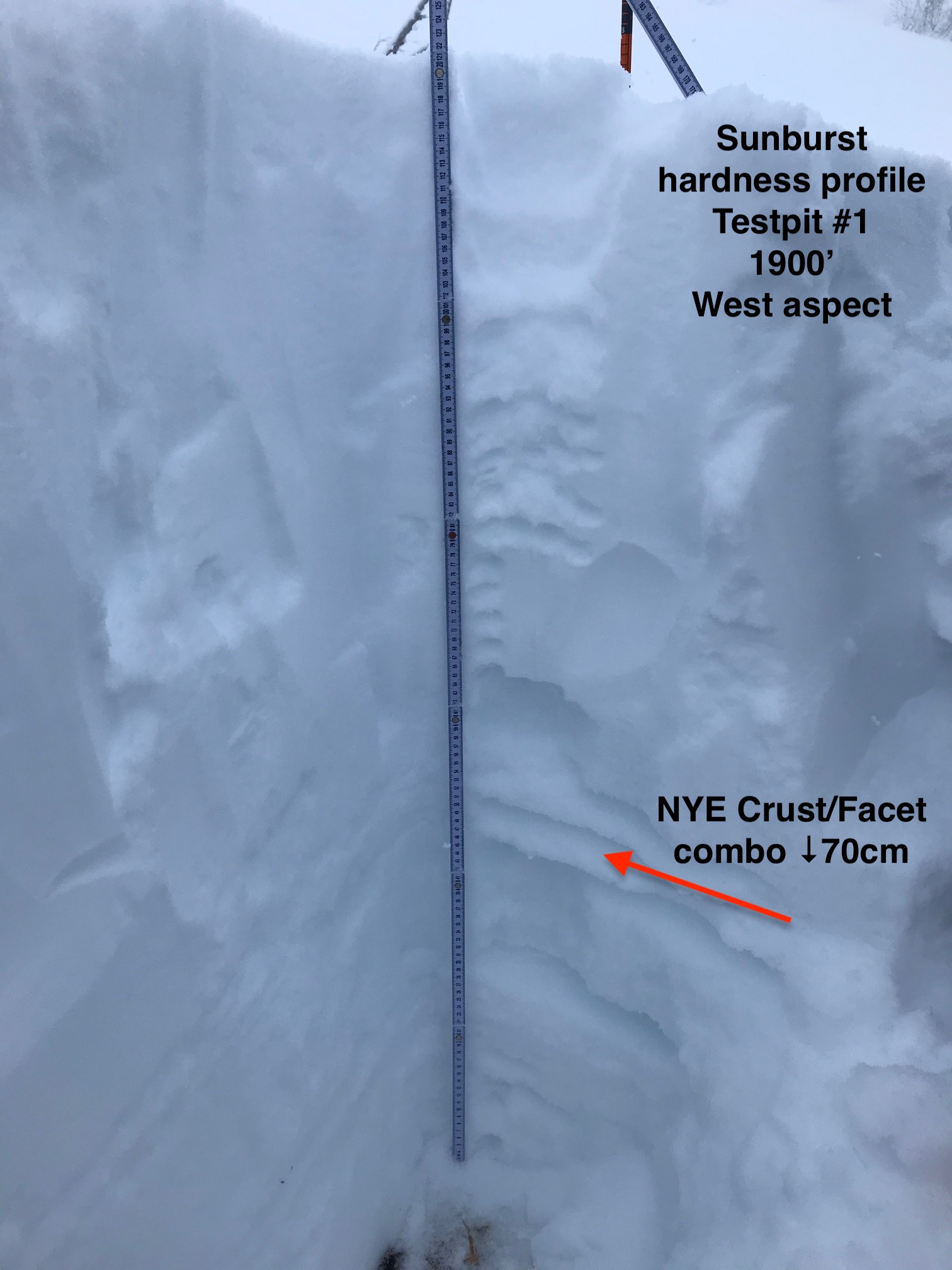
A cross section of the snowpack at 1,900′ showing facets and a crust 28″ (70cm) below the surface. This is just one of several weak layers that are causing so much grief in the snowpack structure.

Avalanche Problem 2
  • Wind Slabs
    Wind Slabs
  • Almost Certain
    Very Likely
    Likely
    Possible
    Unlikely
    Likelihood
  • Historic (D4-5)
    Very Large (D3)
    Large (D2)
    Small (D1)
    Size
Wind Slabs
Wind Slab avalanches are the release of a cohesive layer of snow (a slab) formed by the wind. Wind typically transports snow from the upwind sides of terrain features and deposits snow on the downwind side. Wind slabs are often smooth and rounded and sometimes sound hollow, and can range from soft to hard. Wind slabs that form over a persistent weak layer (surface hoar, depth hoar, or near-surface facets) may be termed Persistent Slabs or may develop into Persistent Slabs.

Likelihood of Avalanches
Terms such as "unlikely", "likely", and "certain" are used to define the scale, with the chance of triggering or observing avalanches increasing as we move up the scale. For our purposes, "Unlikely" means that few avalanches could be triggered in avalanche terrain and natural avalanches are not expected. "Certain" means that humans will be able to trigger avalanches on many slopes, and natural avalanches are expected.

Size of Avalanches
Avalanche size is defined by the largest potential avalanche, or expected range of sizes related to the problem in question. Assigned size is a qualitative estimate based on the destructive classification system and requires specialists to estimate the harm avalanches may cause to hypothetical objects located in the avalanche track (AAA 2016, CAA 2014). Under this schema, "Small" avalanches are not large enough to bury humans and are relatively harmless unless they carry people over cliffs or through trees or rocks. Moving up the scale, avalanches become "Large" enough to bury, injure, or kill people. "Very Large" avalanches may bury or destroy vehicles or houses, and "Historic" avalanches are massive events capable of altering the landscape.

Signal Word Size (D scale) Simple Descriptor
Small 1 Unlikely to bury a person
Large 2 Can bury a person
Very Large 3 Can destroy a house
Historic 4 & 5 Can destroy part or all of a village
More info at Avalanche.org

Storm snow instabilities associated with yesterday’s new snow are something to keep your eye on. These include: wind slabs, storm slabs and loose snow avalanches. With such poor visibility yesterday, we have yet to get a handle on the natural avalanche activity that occurred during the storm. That said, reports from Sunburst point to the new snow beginning to bond, yet lower layers in the snowpack were showing some signs of reactivity.

Storm total (Tuesday night through Thursday morning):

Turnagain Pass:  16-18″ snow (1.3″ water equivalent)
Girdwood:  10-12″ snow (0.8″ water equivalent)
Summit lake:   5-7″ snow (0.4″ water equivalent)

Wind slabs are the most likely storm snow instability to be seen and the slowest to bond. In areas that saw wind loading from the strong easterly winds, these wind slabs (1-2′ thick) could still be touchy. Feel for stiff snow over softer snow and look for cracking in the snow around you. Soft storm slabs (around 1 foot thick) in areas out of the wind effect may also still be possible to trigger. Again, watch for signs of cracking in the new snow. Performing quick hand pits are good ways to see how the new snow is bonding with the older snow surface. On steep slopes, loose snow avalanches (sluffs) may be easy to trigger. Remember, avalanches in the storm snow could step down and trigger large slab as mentioned above.

Cornices:  These have grown over the past 36 hours and we can’t forget to give them a wide berth from above and limit time under them from below.

Very limited visibility was over the area yesterday. This photo is from Sunburst at Turnagain Pass.

Weather
Thu, February 13th, 2020

Yesterday:  The storm system that moved over yesterday added an additional foot of new snow at Turnagain Pass over the past 24-hours, 5-7″ in the Girdwood Valley and 3-4″ in the Summit Lake region. Ridgetop winds were strong from the east in the morning before switching northerly and decreasing to the 10-15mph range for the afternoon and overnight. Temperatures were near 30°F at 2,000′ during the day and have cooled to near 20°F overnight.

Today:  Skies are clearing this morning and some valley fog may persist into the day. Ridgetop winds are slated to blow 10-15mph from the north with gusts near 25mph. Temperatures are on a decline with the cold and dry north winds and should be in the teens along ridgelines and near 20F at the lower elevations. Single digits are on tap for tonight.

Tomorrow:  Mostly clear skies are forecast for Friday along with cold northerly winds (light to moderate) along the peaks. Some cloud cover looks to move in for Saturday and another chance for snow exists Sunday night into early next week. Stay tuned.

PRECIPITATION 24-hour data (6am – 6am)

Temp Avg (F) Snow (in) Water (in) Snow Depth (in)
Center Ridge (1880′) 26 12 0.8 69
Summit Lake (1400′) 20 3 0.2 27
Alyeska Mid (1700′) 25 5 0.4 65

RIDGETOP 24-hour data (6am – 6am)

Temp Avg (F) Wind Dir Wind Avg (mph) Wind Gust (mph)
Sunburst (3812′) 17 E 14 43
Seattle Ridge (2400′) 20 NE 23 11
Observations
Recent Observations for Turnagain Pass
Date Region Location
05/22/23 Turnagain Avalanche: Tincan
05/12/23 Turnagain Avalanche: Tincan, Sunburst, Magnum, Cornbiscuit
05/07/23 Turnagain Observation: Tincan – Bear Tracks
05/05/23 Turnagain Observation: Seattle Ridge
05/02/23 Turnagain Observation: Cornbiscuit
05/02/23 Turnagain Observation: Seward Hwy Turnagain Pass
04/30/23 Turnagain Observation: Magnum
04/29/23 Turnagain Observation: Tincan
04/28/23 Turnagain Avalanche: Taylor Pass/Pastoral
04/28/23 Turnagain Avalanche: Tincan
Riding Areas
Updated Thu, June 01st, 2023

Status of riding areas across the Chugach NF is managed by the Glacier and Seward Ranger Districts, not avalanche center staff. Riding area information is posted as a public service to our users and updated based on snow depth and snow density to prevent resource damage at trailhead locations. Riding area questions contact: mailroom_r10_chugach@fs.fed.us

Area Status Weather & Riding Conditions
Glacier District
Johnson Pass
Closed
Closed May 15.
Placer River
Closed
Closed May 15.
Skookum Drainage
Closed
Will close to motorized use on April 1, 2023 per the National Forest Plan.
Turnagain Pass
Closed
Will close on June 1.
Twentymile
Closed
Scheduled closure May 1.
Seward District
Carter Lake
Closed
Scheduled closure May 1.
Lost Lake Trail
Closed
Scheduled closure May 1.
Primrose Trail
Closed
Scheduled closure May 1.
Resurrection Pass Trail
Closed
Closed to motorized use for the 2022/23 winter season per Forest Plan. Open next season.
Snug Harbor
Closed
Extended opening until May 15.
South Fork Snow River Corridor
Closed
Scheduled closure May 1.
Summit Lake
Closed
Scheduled closure May 1.

Subscribe to Turnagain Pass
Avalanche Forecast by Email

This is a general backcountry avalanche advisory issued for Turnagain Arm with Turnagain Pass as the core advisory area. This advisory does not apply to highways, railroads or operating ski areas.