Turnagain Pass RSS

Archives
ARCHIVED - Forecasts expire after 24 hours.
Issued
Wed, February 10th, 2021 - 7:00AM
Expires
Thu, February 11th, 2021 - 7:00AM
Forecaster
Wendy Wagner
Avalanche risk The Bottom Line

The avalanche danger is MODERATE on slopes above 1,000′. A few inches of new light snow with moderate to strong easterly winds are expected to create fresh and touchy wind slabs today. These slabs should be fairly shallow, in the foot deep or less range. Pay close attention to areas with active and/or recent wind loading. Additionally, there is a chance an older wind slab sitting on weak snow could still be triggered.

The avalanche danger is LOW below 1000’.

PORTAGE VALLEY: More snow (6-8″ by this evening) is expected in Portage Valley toward Whittier. Small natural wind slabs and small cornice falls may occur in the high terrain.

Wed, February 10th, 2021
Alpine
Above 2,500'
2 - Moderate
Avalanche risk
Treeline
1,000'-2,500'
2 - Moderate
Avalanche risk
Below Treeline
Below 1,000'
1 - Low
Avalanche risk
0 - No Rating
1 - Low
2 - Moderate
3 - Considerable
4 - High
5 - Extreme
Avalanche risk Avalanche risk Avalanche risk Avalanche risk Avalanche risk
Travel Advice Generally safe avalanche conditions. Watch for unstable snow on isolated terrain features. Heightened avalanche conditions on specific terrain features. Evaluate snow and terrain carefully; identify features of concern. Dangerous avalanche conditions. Careful snowpack evaluation, cautious route-finding, and conservative decision-making essential. Very dangerous avalanche conditions. Travel in avalanche terrain not recommended. Extraordinarily dangerous avalanche conditions. Avoid all avalanche terrain.
Likelihood of Avalanches Natural and human-triggered avalanches unlikely. Natural avalanches unlikely; human-triggered avalanches possible. Natural avalanches possible; human-triggered avalanches likely. Natural avalanches likely; human-triggered avalanches very likely. Natural and human-triggered avalanches certain.
Avalanche Size and Distribution Small avalanches in isolated areas or extreme terrain. Small avalanches in specific areas; or large avalanches in isolated areas. Small avalanches in many areas; or large avalanches in specific areas; or very large avalanches in isolated areas. Large avalanches in many areas; or very large avalanches in specific areas. Very large avalanches in many areas.
Avalanche Problem 1
  • Wind Slabs
    Wind Slabs
  • Aspect/Elevation
  • Certain
    Very Likely
    Likely
    Possible
    Unlikely
    Likelihood
  • Historic (D4-5)
    Very Large (D3)
    Large (D2)
    Small (D1)
    Size
Wind Slabs
Wind Slab avalanches are the release of a cohesive layer of snow (a slab) formed by the wind. Wind typically transports snow from the upwind sides of terrain features and deposits snow on the downwind side. Wind slabs are often smooth and rounded and sometimes sound hollow, and can range from soft to hard. Wind slabs that form over a persistent weak layer (surface hoar, depth hoar, or near-surface facets) may be termed Persistent Slabs or may develop into Persistent Slabs.

Aspect/Elevation of the Avalanche Problem
Specialists develop a graphic representation of the potential distribution of a particular avalanche problem across the topography. This aspect/elevation rose is used to indicate where the particular avalanche problem is thought to exist on all elevation aspects. Areas where the avalanche problem is thought to exist are colored grey, and it is less likely to be encountered in areas colored white.

Likelihood of Avalanches
Terms such as "unlikely", "likely", and "certain" are used to define the scale, with the chance of triggering or observing avalanches increasing as we move up the scale. For our purposes, "Unlikely" means that few avalanches could be triggered in avalanche terrain and natural avalanches are not expected. "Certain" means that humans will be able to trigger avalanches on many slopes, and natural avalanches are expected.

Size of Avalanches
Avalanche size is defined by the largest potential avalanche, or expected range of sizes related to the problem in question. Assigned size is a qualitative estimate based on the destructive classification system and requires specialists to estimate the harm avalanches may cause to hypothetical objects located in the avalanche track (AAA 2016, CAA 2014). Under this schema, "Small" avalanches are not large enough to bury humans and are relatively harmless unless they carry people over cliffs or through trees or rocks. Moving up the scale, avalanches become "Large" enough to bury, injure, or kill people. "Very Large" avalanches may bury or destroy vehicles or houses, and "Historic" avalanches are massive events capable of altering the landscape.

Signal Word Size (D scale) Simple Descriptor
Small 1 Unlikely to bury a person
Large 2 Can bury a person
Very Large 3 Can destroy a house
Historic 4 & 5 Can destroy part or all of a village
More info at Avalanche.org

Fresh shallow wind slabs, up to a foot deep, will be the name of the game. A few inches of snow and moderate to strong east wind has arrived. The mountains have picked up between 1-3″ of low density snow overnight with another 2-4″ possible today. The snow is sooo light it’ll have an easy time being blown into new drifts and slabs. With such low snow amounts, it will be winds that will be the avalanche problem driver. Ridgetop east winds have been averaging 15-20mph overnight, yet are forecast to increase through the day to 25-35mph and even more tonight with 35-40mph averages.

How much older loose snow exists to be available for transport and add to the size of these new slabs? Well, plenty pending on the location. The northwest winds from last Saturday moved a good portion of it around, especially along the ridgelines, but this is a different wind direction and we can bet older snow will be adding to new slabs. Additionally, slabs could be very touchy as they will be sitting on weak faceted snow and possibly surface hoar.

What to watch for if you’re headed out:

  • Is the wind blowing where you are and actively loading slopes?
  • Do you see/feel stiff snow over softer snow, hollow feeling snow?
  • Any cracks that shoot out from you or collapsing in the snow under you?
  • All these are clues you have found a wind slab.

There is also still a chance a persistent slab avalanche could be triggered. There is an older layer of buried surface hoar from 1.28 that is still on our radar sitting under old wind slabs. It is 8-16″ below the surface and showing signs of becoming harder to fail, which is good news. However, it still deserves our respect. A person or a fresh wind slab triggered may be able to step down to this layer. Something to keep in mind in big terrain.

Sluffs: If there are steep slopes out of wind, watch your sluff. These continue to be easily triggered and high volume in steep sustained terrain.

Cornices: Some cornice development is likely today. As always, give them a wide berth and limit exposure under them.

A look at the top 8″ of snow of the snow pack from Aleph’s field day on Orca yesterday. Soft snow available to be blown around over a future weak layer of buried surface hoar. 2.9.21.

Wind effect along the high terrain from Saturday’s northwest winds. Not a lot of snow to be blown around here, but there is just off the ridgelines. Photo from 4,500′ looking northerly into Skookum drainage and at Byron Pk and Carpathian. 2.8.21.

Additional Concern
  • Glide Avalanches
    Glide Avalanches
Glide Avalanches
Glide Avalanches are the release of the entire snow cover as a result of gliding over the ground. Glide avalanches can be composed of wet, moist, or almost entirely dry snow. They typically occur in very specific paths, where the slope is steep enough and the ground surface is relatively smooth. They are often proceeded by full depth cracks (glide cracks), though the time between the appearance of a crack and an avalanche can vary between seconds and months. Glide avalanches are unlikely to be triggered by a person, are nearly impossible to forecast, and thus pose a hazard that is extremely difficult to manage.
More info at Avalanche.org

After many days without a known glide release, there was one on Penguin Ridge above Girdwood yesterday. Otherwise, cracks are still on the move, slowing opening. It is very prudent to simply avoid being under glide cracks.

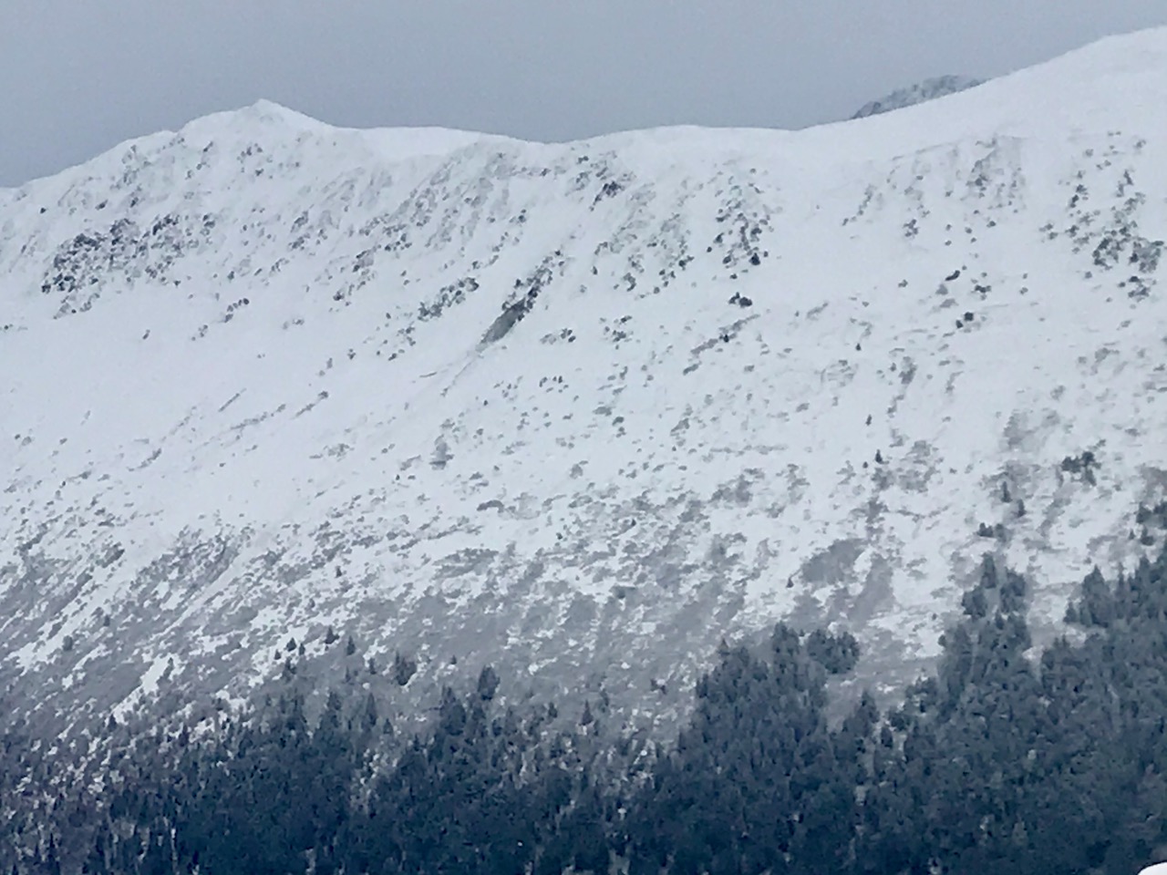
Glide avalanche on Penguin Ridge yesterday. Look for the dark spot in the middle of the photo. 2.9.21.

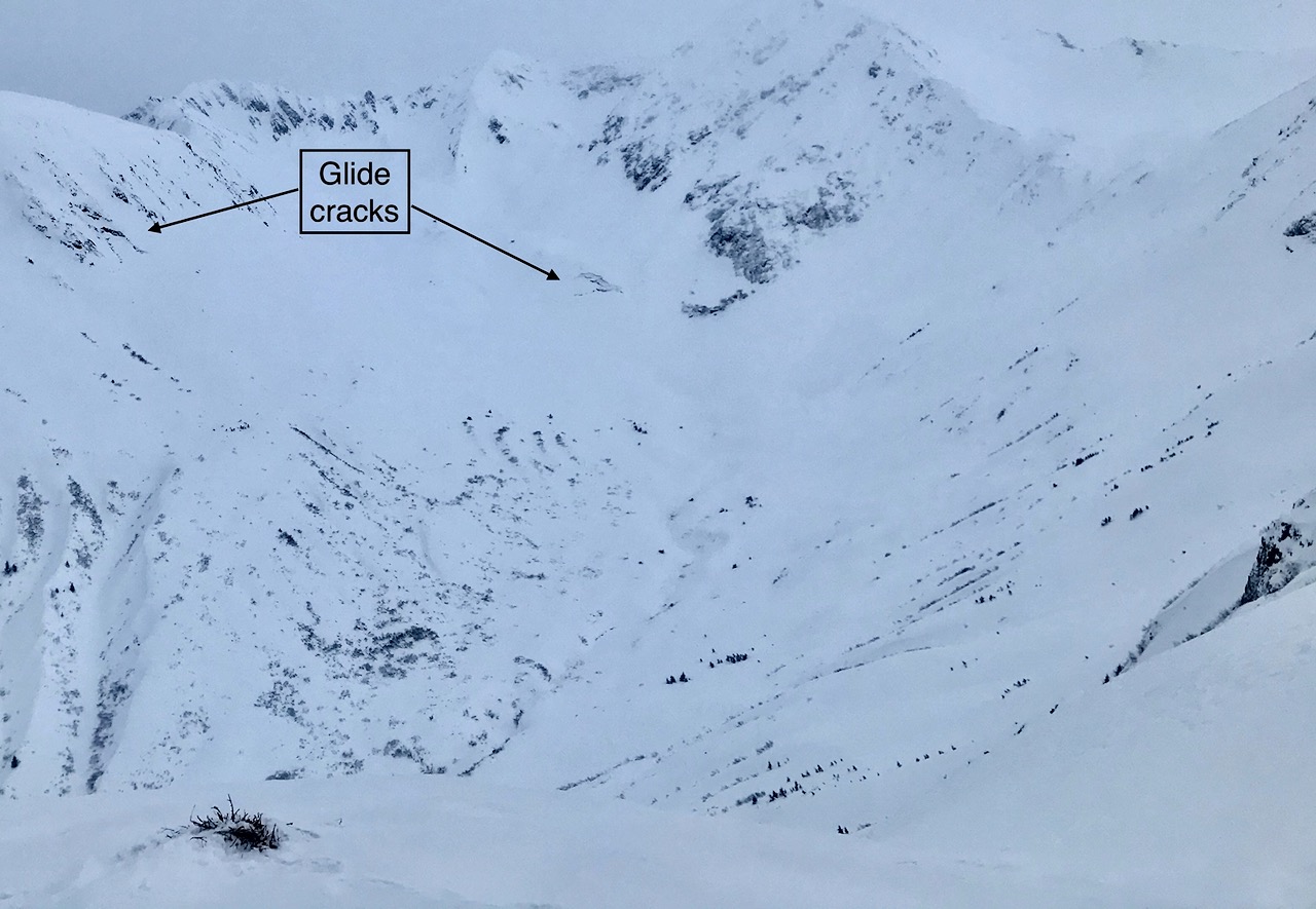
Glide cracks in upper Virgin Creek in the Girdwood area. 2.9.21.

Weather
Wed, February 10th, 2021

Yesterday: Mostly overcast skies filled the region ahead of a light snowfall event that pushed in. Snow began around 5pm and as of 6am this morning only 1-3 inches of very low density snow has accumulated – to sea level. Ridgetop winds bumped up last night from the east with averages of 15-20mph and gusts in the 30’s. Temperatures have climbed in the past 24 hours to the 20’sF at sea level and the mid elevations, while the high elevations are in the teens.

Today: Light snowfall is forecast to continue through the day (to sea level) with another 2-4 inches of very low density snow accumulating. Ridgetop easterly winds will remain elevated and averages are expected in the 25-35mph range with stronger gusts. These winds are forecast to climb higher tonight (35-40 averages). Temperatures should hover in the mid to upper 20’sF from sea level to the mid elevations while ridgetops may get close to 20F.

Tomorrow: Cloudy skies with a few snow flurries are expected tomorrow, with little accumulation. The ridgetop winds look to remain strong from the east (30-40mph) before lessening on Friday as the system moves out. Temperatures look to remain in the 20’s at most elevations.

PRECIPITATION 24-hour data (6am – 6am)

Temp Avg (F) Snow (in) Water (in) Snow Depth (in)
Center Ridge (1880′) 18 1 tr 116
Summit Lake (1400′) 14 2 0.1 44
Alyeska Mid (1700′) 17 3 0.1 109

RIDGETOP 24-hour data (6am – 6am)

Temp Avg (F) Wind Dir Wind Avg (mph) Wind Gust (mph)
Sunburst (3812′) 10 NE 15 32
Seattle Ridge (2400′) 12 SE 12 20
Observations
Recent Observations for Turnagain Pass
Date Region Location
04/21/24 Turnagain Observation: Bertha Creek
04/20/24 Turnagain Avalanche: Spokane Creek
04/16/24 Turnagain Observation: Cornbiscuit
04/15/24 Turnagain Observation: Taylor Pass
04/15/24 Turnagain Observation: Seward Highway – Tern Lake to Portage
04/14/24 Turnagain Observation: Sunburst
04/14/24 Turnagain Observation: Turnagain Pass Snomo
04/13/24 Turnagain Observation: Spokane Creek
04/11/24 Turnagain Observation: Tincan
04/10/24 Turnagain Avalanche: Seattle Ridge
Riding Areas

The riding areas page has moved. Please click here & update your bookmarks.


Subscribe to Turnagain Pass
Avalanche Forecast by Email

This is a general backcountry avalanche advisory issued for Turnagain Arm with Turnagain Pass as the core advisory area. This advisory does not apply to highways, railroads or operating ski areas.