Turnagain Pass RSS

Archives
ARCHIVED - Forecasts expire after 24 hours.
Issued
Tue, February 9th, 2021 - 7:00AM
Expires
Wed, February 10th, 2021 - 7:00AM
Forecaster
Andrew Schauer
Avalanche risk The Bottom Line

The avalanche danger is MODERATE above 1000’, where it is possible to trigger an avalanche up to 1-2’ deep on steep, previously wind-loaded slopes. Most slopes in our area have developed persistent weak layers since our last big snowfall event, and the biggest concern will be where this week snow has been capped by a stiff slab of windblown snow. Winds are expected to pick up this afternoon as the weather pattern shifts, which may make slabs thicker and more reactive later in the day. Pay attention to signs of instability, and avoid steep terrain with stiff snow on the surface.

The avalanche danger is LOW below 1000’.

Tue, February 9th, 2021
Alpine
Above 2,500'
2 - Moderate
Avalanche risk
Treeline
1,000'-2,500'
2 - Moderate
Avalanche risk
Below Treeline
Below 1,000'
1 - Low
Avalanche risk
0 - No Rating
1 - Low
2 - Moderate
3 - Considerable
4 - High
5 - Extreme
Avalanche risk Avalanche risk Avalanche risk Avalanche risk Avalanche risk
Travel Advice Generally safe avalanche conditions. Watch for unstable snow on isolated terrain features. Heightened avalanche conditions on specific terrain features. Evaluate snow and terrain carefully; identify features of concern. Dangerous avalanche conditions. Careful snowpack evaluation, cautious route-finding, and conservative decision-making essential. Very dangerous avalanche conditions. Travel in avalanche terrain not recommended. Extraordinarily dangerous avalanche conditions. Avoid all avalanche terrain.
Likelihood of Avalanches Natural and human-triggered avalanches unlikely. Natural avalanches unlikely; human-triggered avalanches possible. Natural avalanches possible; human-triggered avalanches likely. Natural avalanches likely; human-triggered avalanches very likely. Natural and human-triggered avalanches certain.
Avalanche Size and Distribution Small avalanches in isolated areas or extreme terrain. Small avalanches in specific areas; or large avalanches in isolated areas. Small avalanches in many areas; or large avalanches in specific areas; or very large avalanches in isolated areas. Large avalanches in many areas; or very large avalanches in specific areas. Very large avalanches in many areas.
Recent Avalanches

Summit Lake: We saw multiple recent small human-triggered avalanches at Colorado yesterday, including one that we triggered with a ski cut. These were 6-10” deep, about 50’ wide, and ran anywhere from 20-100’ downslope. More details here.

6-10″ crown of a skier-triggered wind slab avalanche in the Summit Lake area. 02.08.2021

Avalanche Problem 1
  • Persistent Slabs
    Persistent Slabs
  • Certain
    Very Likely
    Likely
    Possible
    Unlikely
    Likelihood
  • Historic (D4-5)
    Very Large (D3)
    Large (D2)
    Small (D1)
    Size
Persistent Slabs
Persistent Slab avalanches are the release of a cohesive layer of snow (a slab) in the middle to upper snowpack, when the bond to an underlying persistent weak layer breaks. Persistent layers include: surface hoar, depth hoar, near-surface facets, or faceted snow. Persistent weak layers can continue to produce avalanches for days, weeks or even months, making them especially dangerous and tricky. As additional snow and wind events build a thicker slab on top of the persistent weak layer, this avalanche problem may develop into a Deep Persistent Slab.

Likelihood of Avalanches
Terms such as "unlikely", "likely", and "certain" are used to define the scale, with the chance of triggering or observing avalanches increasing as we move up the scale. For our purposes, "Unlikely" means that few avalanches could be triggered in avalanche terrain and natural avalanches are not expected. "Certain" means that humans will be able to trigger avalanches on many slopes, and natural avalanches are expected.

Size of Avalanches
Avalanche size is defined by the largest potential avalanche, or expected range of sizes related to the problem in question. Assigned size is a qualitative estimate based on the destructive classification system and requires specialists to estimate the harm avalanches may cause to hypothetical objects located in the avalanche track (AAA 2016, CAA 2014). Under this schema, "Small" avalanches are not large enough to bury humans and are relatively harmless unless they carry people over cliffs or through trees or rocks. Moving up the scale, avalanches become "Large" enough to bury, injure, or kill people. "Very Large" avalanches may bury or destroy vehicles or houses, and "Historic" avalanches are massive events capable of altering the landscape.

Signal Word Size (D scale) Simple Descriptor
Small 1 Unlikely to bury a person
Large 2 Can bury a person
Very Large 3 Can destroy a house
Historic 4 & 5 Can destroy part or all of a village
More info at Avalanche.org

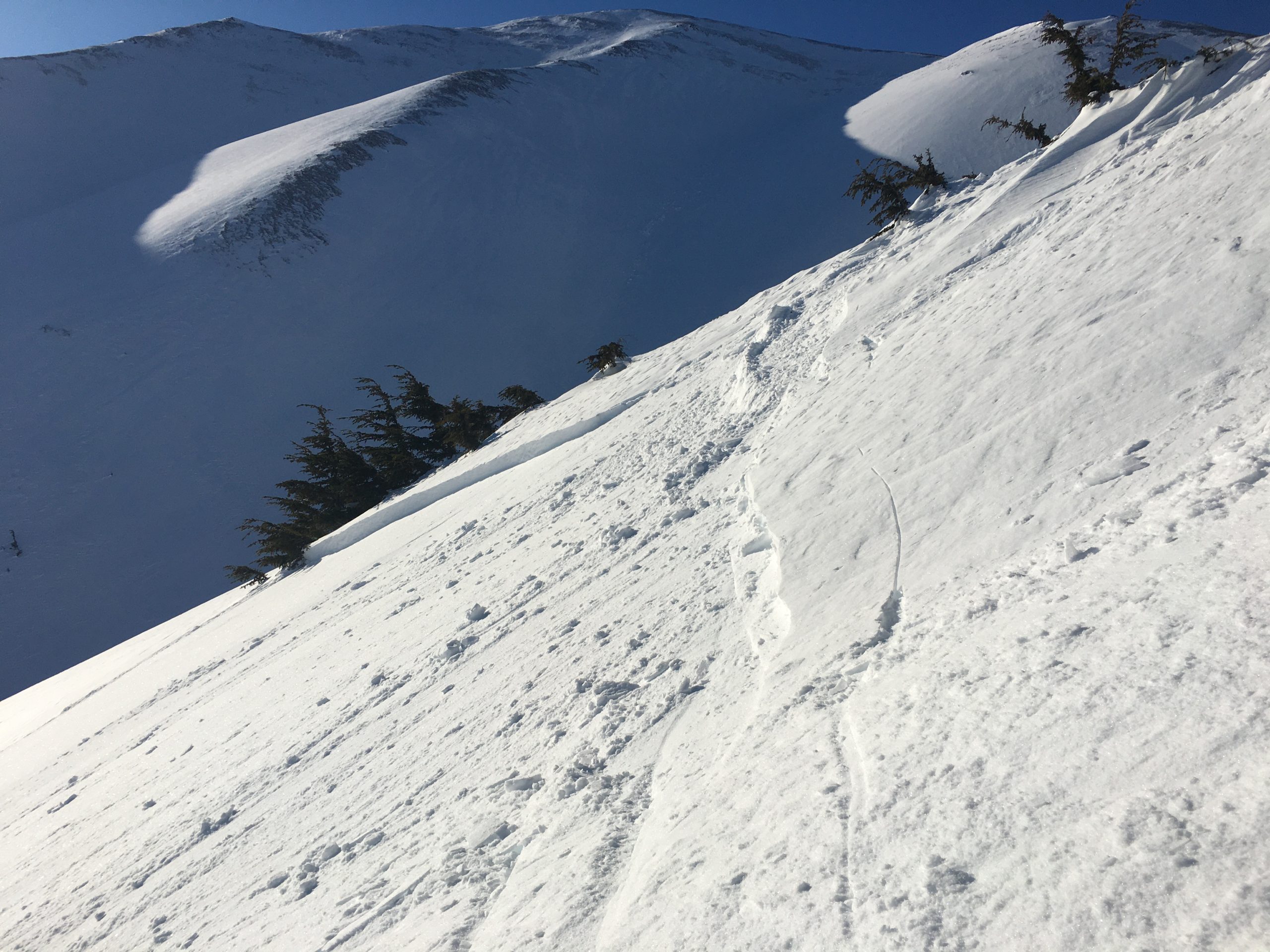
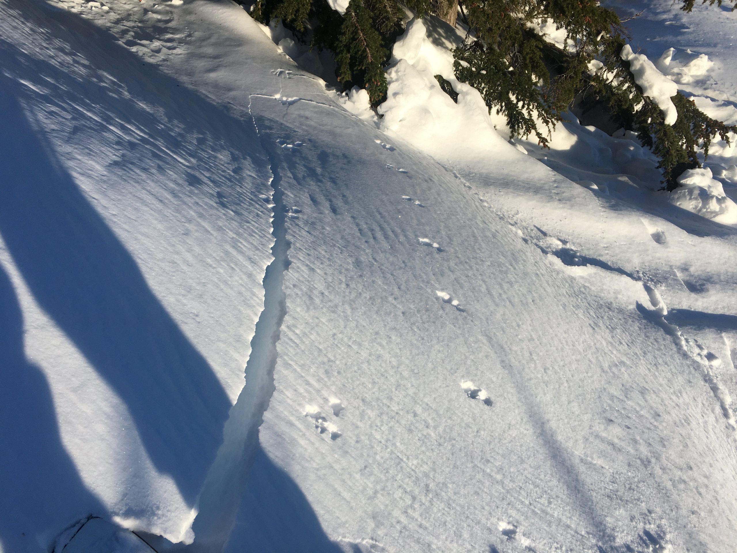
It is still possible to trigger an avalanche up to 1-2’ deep where a stiff slab of snow is capping a persistent weak layer of buried surface hoar and/or near-surface facets. Persistent problems are tricky since they will sometimes, but not always, give you warning signs when they are present. Whenever this snowpack is giving you clear feedback like shooting cracks (see photo below) or collapsing, it is time to dial down your terrain use and stick to low-angle slopes. In the absence of these clear warning signs, look for other clues like previous wind-loading patterns. Do you see a smooth pillow of snow adjacent to a scoured slope? Are you noticing a hollow, punchy slab at the snow surface? These are indicators of previous wind loading, and today it will still be possible to trigger an avalanche where this kind of slab is present. We know the buried weak layers are present on most slopes in our area. They key to safe travel today is recognizing and avoiding steep slopes where there is a stiff slab of snow on top of these persistent weak layers.

Winds are expected to pick up later in the day, with increasing cloud cover as the upper-level winds shift directions. Pay attention to fresh wind slabs forming with the stronger winds, as they will be sensitive to human triggers, and they have the potential to make larger avalanches where snow is getting loaded on top of pre-existing wind slabs.

Loose Snow Avalanches (Sluffs): The surface snow is dry and loose in areas that have been sheltered from the wind. Be aware of fast-moving and high-volume sluffs in steep terrain, which can have serious consequences if they carry you into terrain traps like cliffs, rocks, trees, or gullies.

Cornices: Large cornices are peeling away from ridgelines, opening up large cracks and becoming especially sensitive. If you are traveling along ridgelines be sure to give them plenty of space, and minimize the amount of time you spend traveling below them.

Shooting crack on a wind pillow on Colorado Ridge. 02.08.2021

Valley fog in Turnagain Pass. Photo: Graham Predeger. 02.08.2021

Additional Concern
  • Glide Avalanches
    Glide Avalanches
Glide Avalanches
Glide Avalanches are the release of the entire snow cover as a result of gliding over the ground. Glide avalanches can be composed of wet, moist, or almost entirely dry snow. They typically occur in very specific paths, where the slope is steep enough and the ground surface is relatively smooth. They are often proceeded by full depth cracks (glide cracks), though the time between the appearance of a crack and an avalanche can vary between seconds and months. Glide avalanches are unlikely to be triggered by a person, are nearly impossible to forecast, and thus pose a hazard that is extremely difficult to manage.
More info at Avalanche.org

Glide cracks have opened up throughout the area. These avalanches are unpredictable and they are large since they involve the entire season’s snowpack. Avoid spending any time on or below slopes with glide cracks, as they can release unexpectedly. If you see any new glide activity, please let us know here.

Weather
Tue, February 9th, 2021

Yesterday: A strong temperature inversion kept temperatures down in the single digits to low teens F at lower elevations, with highs in the mid teens to mid 20’s F at upper elevations. The inversion kept a thick layer of valley fog in place, which reached up to around 1800’, and was thick enough to bring a trace of snow to Girdwood. Skies were clear above the fog. Winds were calm to light, blowing 0-10 mph at ridgetops with variable directions.

Today: A change in weather pattern is on the way today, with increasing cloud cover and easterly winds picking up to 15-20 mph this afternoon. High temperatures are expected to reach the mid- to upper teens F, and no precipitation is expected during the day.

Tomorrow: Easterly winds continue to increase tonight, with sustained speeds around 30 mph and gusts approaching 40 mph by tomorrow morning. Temperatures are expected to dip down into the low teens F tonight, with highs expected in the upper teens to mid- 20’s F tomorrow. We are expecting to see some snow tonight and tomorrow, with 1-5” expected by the end of the day.

PRECIPITATION 24-hour data (6am – 6am)

Temp Avg (F) Snow (in) Water (in) Snow Depth (in)
Center Ridge (1880′) 4 0 0 116
Summit Lake (1400′) -4 0 0 42
Alyeska Mid (1700′) 6 0 0 106

RIDGETOP 24-hour data (6am – 6am)

Temp Avg (F) Wind Dir Wind Avg (mph) Wind Gust (mph)
Sunburst (3812′) 10 SW 6 18
Seattle Ridge (2400′) 10 NE 2 6
Observations
Recent Observations for Turnagain Pass
Date Region Location
04/16/24 Turnagain Observation: Cornbiscuit
04/15/24 Turnagain Observation: Taylor Pass
04/15/24 Turnagain Observation: Seward Highway – Tern Lake to Portage
04/14/24 Turnagain Observation: Sunburst
04/14/24 Turnagain Observation: Turnagain Pass Snomo
04/13/24 Turnagain Observation: Spokane Creek
04/11/24 Turnagain Observation: Tincan
04/10/24 Turnagain Avalanche: Seattle Ridge
04/10/24 Turnagain Observation: Cornbiscuit South Face
04/10/24 Turnagain Avalanche: Tincan
Riding Areas

The riding areas page has moved. Please click here & update your bookmarks.


Subscribe to Turnagain Pass
Avalanche Forecast by Email

This is a general backcountry avalanche advisory issued for Turnagain Arm with Turnagain Pass as the core advisory area. This advisory does not apply to highways, railroads or operating ski areas.