Turnagain Pass
|
![]() ![]() |
The avalanche danger remains MODERATE above 1000′. Large human triggered avalanches are possible on a buried weak layer of surface hoar 2-3′ deep. This layer exists across the forecast area and it is unpredictable where it can still produce avalanches. To avoid this problem we recommend sticking to lower angle terrain and being aware of any terrain traps below. Below 1000′ the avalanche danger is LOW.
Join us on Valentine’s Day (Feb 14th) for Snowball! Dance to lively music by the Jangle Bees, bid on the silent auction, and enjoy 49th State Brewing libations and decadent desserts. Bring your sweetie or your best backcountry partners—or find new ones on the dance floor. All proceeds from this event benefit the Friends of the Chugach Avalanche Center and the Alaska Avalanche School, so you can let loose knowing it’s for a great cause! Tickets are limited, so get yours soon. Click here for tickets and more information.
![]() |
![]() |
![]() |
![]() |
![]() |
|
Travel Advice | Generally safe avalanche conditions. Watch for unstable snow on isolated terrain features. | Heightened avalanche conditions on specific terrain features. Evaluate snow and terrain carefully; identify features of concern. | Dangerous avalanche conditions. Careful snowpack evaluation, cautious route-finding, and conservative decision-making essential. | Very dangerous avalanche conditions. Travel in avalanche terrain not recommended. | Extraordinarily dangerous avalanche conditions. Avoid all avalanche terrain. |
Likelihood of Avalanches | Natural and human-triggered avalanches unlikely. | Natural avalanches unlikely; human-triggered avalanches possible. | Natural avalanches possible; human-triggered avalanches likely. | Natural avalanches likely; human-triggered avalanches very likely. | Natural and human-triggered avalanches certain. |
Avalanche Size and Distribution | Small avalanches in isolated areas or extreme terrain. | Small avalanches in specific areas; or large avalanches in isolated areas. | Small avalanches in many areas; or large avalanches in specific areas; or very large avalanches in isolated areas. | Large avalanches in many areas; or very large avalanches in specific areas. | Very large avalanches in many areas. |
It has been about two weeks since the last string of human triggered avalanches on our weak layer of buried surface hoar from 1/10. This past weekend the warm temperatures caused widespread loose snow avalanches. Some of these loose snow avalanches triggered slabs, one of which released on buried surface hoar on Goat Mountain in Girdwood Valley. That is the last avalanche activity we know of in the forecast region.
Signal Word | Size (D scale) | Simple Descriptor |
Small | 1 | Unlikely to bury a person |
Large | 2 | Can bury a person |
Very Large | 3 | Can destroy a house |
Historic | 4 & 5 | Can destroy part or all of a village |
Another day of relatively calm weather in the forecast area with light snowfall (1-2″) and calm winds. Visibility will likely be the biggest challenge, with low elevation cloud cover expected to persist through most of the day before a brief clearing period this afternoon. Things will be changing tomorrow with strong winds and heavy snowfall expected, stay tuned!
Our primary avalanche concern continues to be a layer of surface hoar (1/10) buried 2-3′ deep that exists across the forecast area. Over the past two weeks this layer has been gradually gaining strength and we have seen less alarming results in our snow pit tests and much less avalanche activity. However, we call these ‘persistent slabs’ for a reason. It is still possible to trigger a large avalanche in areas where the surface hoar is well preserved. The most likely areas to trigger an avalanche are above 2000′ and in regions with a generally thinner and weaker snowpack where the weak layer is more accessible.
To avoid this avalanche problem we recommend sticking to lower angle terrain and being aware of any overhead avalanche terrain, especially if there are other groups travelling above you. Assessing this weak layer is getting more difficult as it gets older. It is harder to find in the snowpack (see photo below) and snow pit tests are less consistent. The best approach to identify and assess the weak layer is to dig a snow pit and use a compression test or extended column test to evaluate how reactive the weak layer is in your area. Unfortunately, even if you get stable results in a snowpit there is always some uncertainty with persistent weak layers. The only way to be sure to avoid this problem is to stick to mellow terrain.
In addition to our deeply buried weak layers, loose snow avalanches are possible in steeper terrain. We have had some incremental snowfall this weak that is adding up to enough volume where you could get a decent sluff moving in steeper terrain.
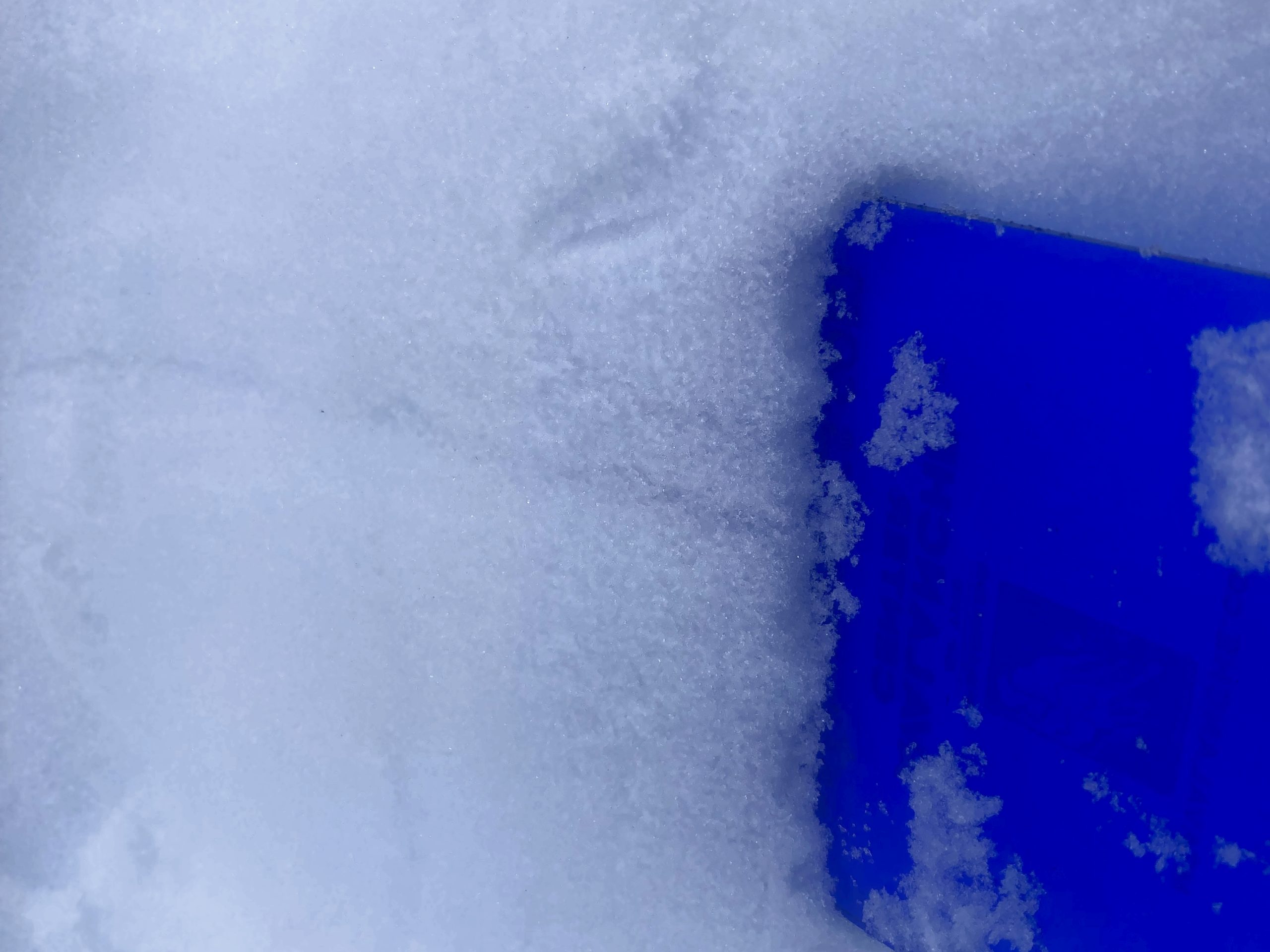
The 1/10 buried surface hoar layer near the crown of an avalanche that released naturally last weekend. Photo 2.2.23
The monster lurking near the base of the snowpack is still on our radar, even though it has been almost a month since the last activity on the Thanksgiving facet/crust layer which is now buried 4-8′ deep. We continue to see this layer in areas with a thinner snowpack, but it is unlikely to trigger an avalanche on it due to the strength of the snowpack above.
Yesterday: Cloud cover was in and out yesterday, oscillating between obscured skies and mostly cloudy conditions. Winds were light with average speed of 0-10 mph at upper elevations and gusts to 15 mph. Temperatures were in the upper twenties at sea level to high teens at upper elevations. On and off snow showers provided an additional roughly 1-3″ of snowfall, however the SNOTEL sites are down as of 5 am on Feb 4th so we have no snowfall information from Turnagain Pass.
Today: Light snowfall is expected today with 1-3″ of accumulation expected. Girdwood and Portage area are expected to be favored over Turnagain Pass. Snow level will remain at sea level. Winds should remain light out of the south with averages of 0-10 mph. Thick cloud cover is forecast for the first half of the day, followed by mostly cloudy conditions in the afternoon.
Tomorrow: Winds are expected to pick up early Sunday morning and become strong throughout the day with averages of 40-60 mph and gusts of 75+ mph at upper elevations. Heavier snowfall is also expected to start on Sunday with 8-12″ expected by Monday morning and higher totals near Prince William Sound. Snow level should stay low at 100-200′ on Sunday and Monday.
PRECIPITATION 24-hour data (6am – 6am)
Temp Avg (F) | Snow (in) | Water (in) | Snow Depth (in) | |
---|---|---|---|---|
Center Ridge (1880′) | – | – | – | – |
Summit Lake (1400′) | – | ~2 | – | – |
Alyeska Mid (1700′) | 24 | 2 | 0.17 | 64 |
Bear Valley – Portage (132′) | 28 | 3 | 0.24 | – |
* SNOTEL sites across Alaska are not reporting data as of 5am Saturday, February 4th
RIDGETOP 24-hour data (6am – 6am)
Temp Avg (F) | Wind Dir | Wind Avg (mph) | Wind Gust (mph) | |
---|---|---|---|---|
Sunburst (3812′) | 18 | E | 4 | 16 |
Seattle Ridge (2400′) | 20 | E | 1 | 6 |
Date | Region | Location | Observer |
---|---|---|---|
10/27/24 | Turnagain | Observation: Tincan | Michael Kerst |
10/21/24 | Turnagain | Observation: Turnagain Pass Road Observation | Trevor Clayton |
10/19/24 | Turnagain | Observation: Tincan – Below Todds Run | Andy Moderow |
10/18/24 | Turnagain | Observation: Taylor Pass | Eli Neuffer |
10/15/24 | Turnagain | Observation: Tincan Common | John Sykes Forecaster |
10/14/24 | Turnagain | Avalanche: Tincan | CNFAC Staff |
05/13/24 | Turnagain | Observation: Eddie’s, Sunburst, Seattle, Cornbiscuit, Pete’s South | H Thamm |
05/13/24 | Turnagain | Observation: Turnagain Pass non-motorized side | Amy Holman |
05/12/24 | Turnagain | Observation: Warm up Bowl | Tony Naciuk |
05/07/24 | Turnagain | Observation: Turnagain Pass Wet Slabs | A S |
The riding areas page has moved. Please click here & update your bookmarks.
Subscribe to Turnagain Pass
Avalanche Forecast by Email