Turnagain Pass Avalanche Forecast RSS

Archives
ARCHIVED FORECAST - All forecasts expire after 24 hours from the posting date/time.
Issued
Mon, February 3rd, 2020 - 7:00AM
Expires
Tue, February 4th, 2020 - 7:00AM
Forecaster
Aleph Johnston-Bloom
Avalanche risk The Bottom Line

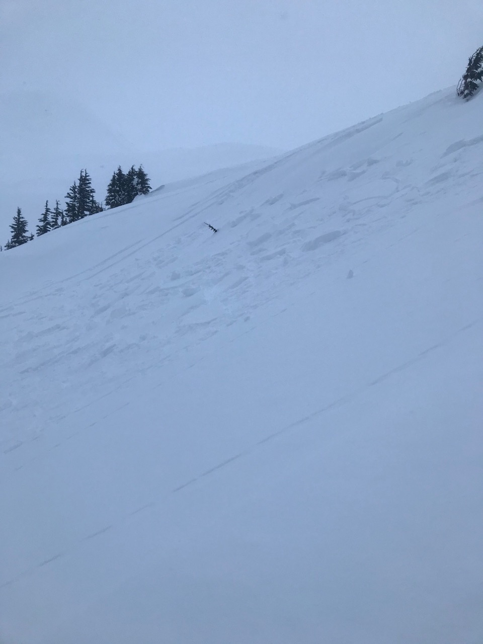
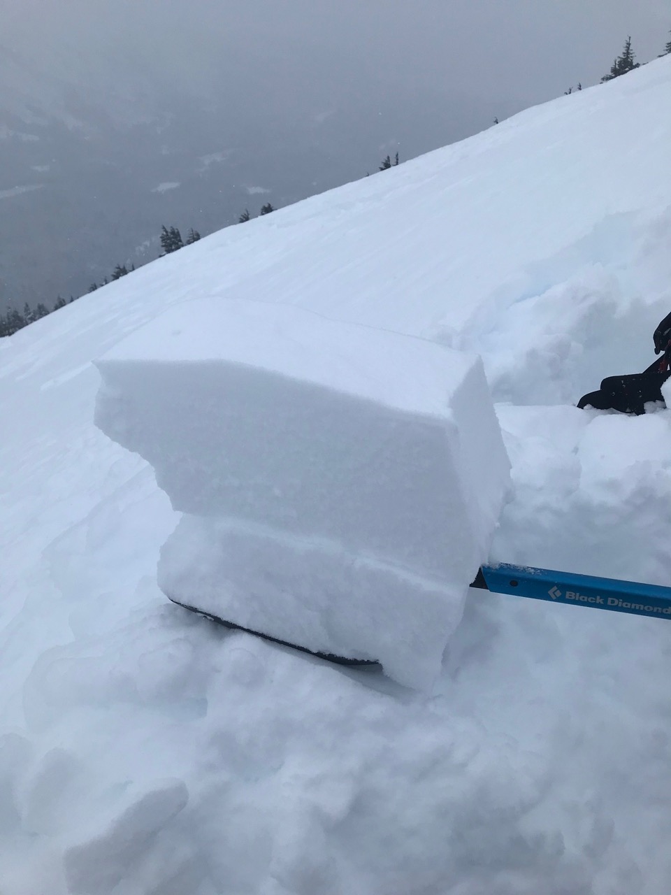
The avalanche danger is CONSIDERABLE above 1000′. The continued wind loading today and weak snow buried in the snowpack are making for tricky avalanche conditions.  Human triggered wind slabs are likely in steep leeward terrain and naturals are possible. In addition, triggering a large dangerous avalanche that breaks deeper in the snowpack is also possible. Choose terrain very carefully and use good travel protocol.

REGION WIDE: Strong winds have impacted from Seward to Anchorage over the past few days. Wind slab avalanches are concern, extra caution is advised. Be on the lookout for wind hardened and hollow sounding snow. There was a skier triggered wind slab on Peak 3 yesterday and a wind slab that caught two people in Kincaid on Saturday.

Special Announcements

Tomorrow night! Soldotna Avalanche Awareness. Join CNFAIC’s Aleph Johnston-Bloom for an evening avalanche awareness chat. 6-7:30 pm at Odie’s in Soldotna. FREE! Great information for those new to recreating in the backcountry and useful review for experienced folks. Geared to all modes of travel. Hope to see you there!

Avalanche Gear in Review with CNFAIC at Black Diamond.  Swing by Black Diamond in Anchorage for a discussion on avalanche rescue gear. Thursday, Feb 6th from 6-7:30pm. Free! CNFAIC forecasters Ryan Van Luit and Wendy Wagner will be there to discuss advances, common mishaps and answer any questions you may have about your own rescue gear. BYOG – Bring Your Own Gear! This is a great opportunity to test your own gear and ask questions.

Thanks to our sponsors!
Mon, February 3rd, 2020
Alpine
Above 2,500'
Considerable (3)
Avalanche risk
Treeline
1,000'-2,500'
Considerable (3)
Avalanche risk
Below Treeline
Below 1,000'
Moderate (2)
Avalanche risk
Alpine
Above 2,500'
Avalanche risk
Considerable (3)
Treeline
1,000'-2,500'
Avalanche risk
Considerable (3)
Below Treeline
Below 1,000'
Avalanche risk
Moderate (2)
Danger Scale:
No Rating (0)
Low (1)
Moderate (2)
Considerable (3)
High (4)
Extreme (5)
Avalanche Problem 1
  • Wind Slabs
    Wind Slabs
  • Almost Certain
    Very Likely
    Likely
    Possible
    Unlikely
    Likelihood
  • Historic (D4-5)
    Very Large (D3)
    Large (D2)
    Small (D1)
    Size
Wind Slabs
Wind Slab avalanches are the release of a cohesive layer of snow (a slab) formed by the wind. Wind typically transports snow from the upwind sides of terrain features and deposits snow on the downwind side. Wind slabs are often smooth and rounded and sometimes sound hollow, and can range from soft to hard. Wind slabs that form over a persistent weak layer (surface hoar, depth hoar, or near-surface facets) may be termed Persistent Slabs or may develop into Persistent Slabs.

Likelihood of Avalanches
Terms such as "unlikely", "likely", and "certain" are used to define the scale, with the chance of triggering or observing avalanches increasing as we move up the scale. For our purposes, "Unlikely" means that few avalanches could be triggered in avalanche terrain and natural avalanches are not expected. "Certain" means that humans will be able to trigger avalanches on many slopes, and natural avalanches are expected.

Size of Avalanches
Avalanche size is defined by the largest potential avalanche, or expected range of sizes related to the problem in question. Assigned size is a qualitative estimate based on the destructive classification system and requires specialists to estimate the harm avalanches may cause to hypothetical objects located in the avalanche track (AAA 2016, CAA 2014). Under this schema, "Small" avalanches are not large enough to bury humans and are relatively harmless unless they carry people over cliffs or through trees or rocks. Moving up the scale, avalanches become "Large" enough to bury, injure, or kill people. "Very Large" avalanches may bury or destroy vehicles or houses, and "Historic" avalanches are massive events capable of altering the landscape.

Signal Word Size (D scale) Simple Descriptor
Small 1 Unlikely to bury a person
Large 2 Can bury a person
Very Large 3 Can destroy a house
Historic 4 & 5 Can destroy part or all of a village
More info at Avalanche.org

There were a few skier triggered wind slab avalanches on Saturday during the sustained northwest outflow winds. Observers reported cracking, collapsing and easy to trigger test slopes. The winds shifted to the east yesterday blowing 10-20 mph gusting into the 40s and are forecast to continue today.  The winds are strong enough to keep moving snow. Triggering a wind slab in steep leeward terrain remains likely. Because the winds flip-flopped direction determining what slopes are freshly loaded might be tricky. Be suspect of stiff snow over soft snow, hollow sounding snow and watch for cracking.  Triggering a wind slab may also add weight to the snowpack and overload buried weak layers resulting in a deeper and more dangerous avalanche (Problem 2).

Cornices:  Blowing snow builds cornices which could be touchy and on both sides of the ridgelines due to the shifting winds. Remember these may break farther back than expected.

Small skier triggered wind slab that likely occurred on Saturday, 2.1.20. Photo from 2.2.20.

An upper layer of stiff surface snow showing wind slab over softer snow in a snow pit on Eddies at 1800′, 2.2.20.

Avalanche Problem 2
  • Persistent Slabs
    Persistent Slabs
  • Almost Certain
    Very Likely
    Likely
    Possible
    Unlikely
    Likelihood
  • Historic (D4-5)
    Very Large (D3)
    Large (D2)
    Small (D1)
    Size
Persistent Slabs
Persistent Slab avalanches are the release of a cohesive layer of snow (a slab) in the middle to upper snowpack, when the bond to an underlying persistent weak layer breaks. Persistent layers include: surface hoar, depth hoar, near-surface facets, or faceted snow. Persistent weak layers can continue to produce avalanches for days, weeks or even months, making them especially dangerous and tricky. As additional snow and wind events build a thicker slab on top of the persistent weak layer, this avalanche problem may develop into a Deep Persistent Slab.

Likelihood of Avalanches
Terms such as "unlikely", "likely", and "certain" are used to define the scale, with the chance of triggering or observing avalanches increasing as we move up the scale. For our purposes, "Unlikely" means that few avalanches could be triggered in avalanche terrain and natural avalanches are not expected. "Certain" means that humans will be able to trigger avalanches on many slopes, and natural avalanches are expected.

Size of Avalanches
Avalanche size is defined by the largest potential avalanche, or expected range of sizes related to the problem in question. Assigned size is a qualitative estimate based on the destructive classification system and requires specialists to estimate the harm avalanches may cause to hypothetical objects located in the avalanche track (AAA 2016, CAA 2014). Under this schema, "Small" avalanches are not large enough to bury humans and are relatively harmless unless they carry people over cliffs or through trees or rocks. Moving up the scale, avalanches become "Large" enough to bury, injure, or kill people. "Very Large" avalanches may bury or destroy vehicles or houses, and "Historic" avalanches are massive events capable of altering the landscape.

Signal Word Size (D scale) Simple Descriptor
Small 1 Unlikely to bury a person
Large 2 Can bury a person
Very Large 3 Can destroy a house
Historic 4 & 5 Can destroy part or all of a village
More info at Avalanche.org

Triggering a large, dangerous slab avalanche is possible today. Conservative terrain choices are essential. As you pick slopes to travel on, think about the consequences of a large avalanche being initiated. Where would you end up? If you have been following the forecast you know we have been talking a lot about slabs forming over weak snow. This weak snow is from the cold clear weather that dominated for most of January. A series of storms and wind events have now buried this weak snow (buried surface hoar and facets) 2-3+ feet deep. A natural avalanche cycle occurred on January 29th with some large avalanches occurring that we believe failed on this weak snow. Over the weekend there were couple of smaller skier triggered avalanches that may also have failed on this. One was confirmed to have slid on the buried surface hoar/facets. The winds keep adding weight to the snow above and temperatures have increased significantly in the last 24 hrs. Valley temperatures in Portage went from -15°F to 30°F and Center Ridge (1880′) temperatures went from 7°F to 25°F. This temperature change will increase settlement and could make the upper layers of the snowpack more cohesive/slabby. Our worry is that the more the slab develops over the weak layers, the larger and more connected the avalanches will be. We know the weak layers are down there lurking. Snowpack tests yesterday illustrated that is might be harder to trigger an avalanche but that may change with the slab character increasing. Is the slab now just waiting for a trigger today? This type of avalanche may allow more than one person on skis or a snowmachine to travel on the slope before it releases.

Skier triggered avalanche that we believe occurred on Saturday 2.1.20 on Eddies. Photo taken on 2.2..20. This avalanche failed on the buried surface hoar/facet layer.

Buried surface hoar intact over small facets in the crown investigation of the Eddies avalanche that failed on the buried weak layers. 2.2.20.

Slab over the buried surface hoar and facets. Eddies. 2.2.20

Weather
Mon, February 3rd, 2020

Yesterday: Cloudy skies with light snow starting mid-day. Winds were easterly 10-20 mph gusting into the 50s. Temperatures went from below zero/single digits to mid 20Fs. Snow showers and gusty winds continued overnight.

Today: Mostly cloudy with scattered snow showers. Winds will remain elevated and easterly 10-20 mph gusting into the 40s in the morning and eventually decrease overnight. Temperatures will be in the mid to high 20Fs. Snow is forecast to increase a bit overnight with a couple of inches possible.

Tomorrow: Mostly cloudy with light snow showers in the morning tapering off in the afternoon. Winds will be light and westerly and temperatures will remain in the 20Fs. Anther shot of light snow overnight and an active pattern continuing through the week.

PRECIPITATION 24-hour data (6am – 6am)

Temp Avg (F) Snow (in) Water (in) Snow Depth (in)
Center Ridge (1880′) 15 1-2 0.2 58
Summit Lake (1400′) 10 1-2 0.2 20
Alyeska Mid (1700′) 13 4 0.17 56

RIDGETOP 24-hour data (6am – 6am)

Temp Avg (F) Wind Dir Wind Avg (mph) Wind Gust (mph)
Sunburst (3812′) 8 NE 13 52
Seattle Ridge (2400′) 11 SE 13 31
Observations
Recent Observations for Turnagain Pass
Date Region Location
05/22/23 Turnagain Avalanche: Tincan
05/12/23 Turnagain Avalanche: Tincan, Sunburst, Magnum, Cornbiscuit
05/07/23 Turnagain Observation: Tincan – Bear Tracks
05/05/23 Turnagain Observation: Seattle Ridge
05/02/23 Turnagain Observation: Cornbiscuit
05/02/23 Turnagain Observation: Seward Hwy Turnagain Pass
04/30/23 Turnagain Observation: Magnum
04/29/23 Turnagain Observation: Tincan
04/28/23 Turnagain Avalanche: Taylor Pass/Pastoral
04/28/23 Turnagain Avalanche: Tincan
Riding Areas
Updated Thu, June 01st, 2023

Status of riding areas across the Chugach NF is managed by the Glacier and Seward Ranger Districts, not avalanche center staff. Riding area information is posted as a public service to our users and updated based on snow depth and snow density to prevent resource damage at trailhead locations. Riding area questions contact: mailroom_r10_chugach@fs.fed.us

Area Status Weather & Riding Conditions
Glacier District
Johnson Pass
Closed
Closed May 15.
Placer River
Closed
Closed May 15.
Skookum Drainage
Closed
Will close to motorized use on April 1, 2023 per the National Forest Plan.
Turnagain Pass
Closed
Will close on June 1.
Twentymile
Closed
Scheduled closure May 1.
Seward District
Carter Lake
Closed
Scheduled closure May 1.
Lost Lake Trail
Closed
Scheduled closure May 1.
Primrose Trail
Closed
Scheduled closure May 1.
Resurrection Pass Trail
Closed
Closed to motorized use for the 2022/23 winter season per Forest Plan. Open next season.
Snug Harbor
Closed
Extended opening until May 15.
South Fork Snow River Corridor
Closed
Scheduled closure May 1.
Summit Lake
Closed
Scheduled closure May 1.

Subscribe to Turnagain Pass
Avalanche Forecast by Email

This is a general backcountry avalanche advisory issued for Turnagain Arm with Turnagain Pass as the core advisory area. This advisory does not apply to highways, railroads or operating ski areas.