Turnagain Pass Avalanche Forecast
|
![]() ![]() |
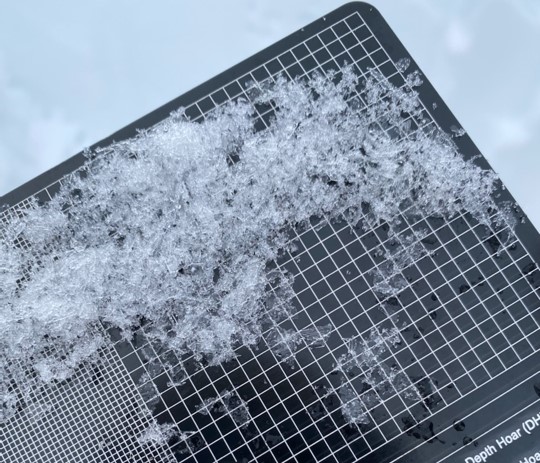
The avalanche danger is MODERATE above 1000′. It is still possible for a person to trigger a large avalanche on a layer of surface hoar buried 2-3′ deep. This layer is widespread across the advisory area, which is keeping us sticking to smaller, low-consequence terrain free of terrain traps in case we find the slope where a person can trigger an avalanche. You can avoid the problem entirely by avoiding slopes steeper than 30 degrees. The danger is LOW below 1000′.
SUMMIT LAKE: The snowpack in the Summit Lake area has a similar structure to Turnagain Pass, but it is thinner and weaker. This makes human-triggered avalanches a little more likely, which means we should be a little more cautious around steep terrain.
Headed to Hatcher Pass today? be sure to get their forecast at hpavalanche.org.
Tickets on Sale Now for the Snowball on Feb. 14! Join us on Valentine’s Day to celebrate a great snow season. Dance to lively music by the Jangle Bees, bid on the silent auction, and enjoy 49th State Brewing libations and decadent desserts. Bring your sweetie or your best backcountry partners—or find new ones on the dance floor. All proceeds from this event benefit the Friends of the Chugach Avalanche Center and the Alaska Avalanche School, so you can let loose knowing it’s for a great cause! Tickets are limited, so get yours soon. Click here for tickets and more information.
Signal Word | Size (D scale) | Simple Descriptor |
Small | 1 | Unlikely to bury a person |
Large | 2 | Can bury a person |
Very Large | 3 | Can destroy a house |
Historic | 4 & 5 | Can destroy part or all of a village |
It’s Groundhog Day today, literally and figuratively. We’re looking at another cloudy day with cooler temps and light winds, and nothing has changed in the snowpack since yesterday. Without any big changes expected in the weather today, our primary concern is the lingering possibility of triggering a large avalanche on the layer of surface hoar buried 2-3′ deep across our advisory area. We know this layer is slowly gaining strength and becoming more stubborn to trigger, but it is not quite to the point where we can write it off as being unreactive. Part of the uncertainty we are dealing with right now comes from the fact that there just hasn’t been a whole lot of traffic at Turnagain Pass lately– which means observations on this layer have been sparse since the string of human-triggered avalanches almost two weeks ago.
For now, we are starting to feel comfortable pushing into some steeper terrain, but we are doing it very carefully. This means taking the time to assess the weak layer where we are traveling by digging down and testing it before getting on steeper slopes. Any red flags like shooting cracks or collapsing should be enough reason to back off steep terrain. Because of the uncertainty associated with this weak layer, we are starting really small with steep terrain. This means smaller features and shorter slopes without any terrain traps that increase the consequences of getting caught in an avalanche– things like gullies, rocks, trees or cliffs in the avalanche path. You can avoid the problem entirely by simply sticking to slopes less than 30 degrees. If you do get out and assess this weak layer, consider taking the time to submit an observation. That will help us paint a better picture of how well this layer is healing.
A sample of the buried surface hoar from Tenderfoot yesterday. This is outside of our advisory area, but the structure was similar to what we’ve been seeing around Turnagain Pass and Girdwood. Photo Megan Guinn. 02.01.2023
It’s been nearly a month since the last confirmed activity on the Thanksgiving crust/facet layer. The layer hasn’t gone away, but at this point it is becoming very unlikely a person could trigger an avalanche that deep. As we continue in our stretch of very quiet weather, it is feeling appropriate to file this layer as an additional concern– something that is present in the snowpack but would be really surprising to see a person trigger an avalanche on it. If someone were to be able to find a spot to make a really big avalanche, it would be at a higher elevation in an area with a thin snowpack, where the weight of a person can still impact the weak layer. Things can change if we see a major loading event or a significant warming event down the road, but for now it is a layer we are tracking but not expecting to see any activity on.
Yesterday: Skies were mostly cloudy with light winds blowing 5-10 mph out of variable directions. Periods of precipitation brought a trace of snow in some parts of the advisory area, with snow to sea level. Temperatures were coldest yesterday morning, with lows in the low 20’s F and highs getting up to the low 30’s in the valleys and mid to upper 20’s at higher elevations.
Today: We’re expecting a similar day to yesterday, with mostly cloudy skies and periods of light snow bringing a trace to 2” snow during the day. Winds will be light out of the south with high temperatures in the upper 20’s F and lows in the low 20’s F.
Tomorrow: More of the same tomorrow, with cloudy skies and light winds out of the south. Temperatures should be a little cooler than today, with highs in the mid 20’s F and lows dipping into the high teens to low 20’s F. Light precipitation should only bring a trace of snow, with snow to sea level. Chances are still looking good for a more significant storm starting Sunday, stay tuned for more.
PRECIPITATION 24-hour data (6am – 6am)
Temp Avg (F) | Snow (in) | Water (in) | Snow Depth (in) | |
---|---|---|---|---|
Center Ridge (1880′) | 28 | tr | 0 | 62 |
Summit Lake (1400′) | 24 | tr | 0 | 34 |
Alyeska Mid (1700′) | 30 | tr | 0.02 | 61 |
Bear Valley – Portage (132′) | 29 | tr | 0.07 | – |
RIDGETOP 24-hour data (6am – 6am)
Temp Avg (F) | Wind Dir | Wind Avg (mph) | Wind Gust (mph) | |
---|---|---|---|---|
Sunburst (3812′) | 21 | E | 4 | 15 |
Seattle Ridge (2400′) | 24 | E | 4 | 11 |
Date | Region | Location | Observer |
---|---|---|---|
05/22/23 | Turnagain | Avalanche: Tincan | Nick D'Alessio |
05/12/23 | Turnagain | Avalanche: Tincan, Sunburst, Magnum, Cornbiscuit | Heather Thamm |
05/07/23 | Turnagain | Observation: Tincan – Bear Tracks | CNFAIC Staff |
05/05/23 | Turnagain | Observation: Seattle Ridge | AS/ WW Forecaster |
05/02/23 | Turnagain | Observation: Cornbiscuit | Schauer/ Sturgess Forecaster |
05/02/23 | Turnagain | Observation: Seward Hwy Turnagain Pass | Joel Curtis |
04/30/23 | Turnagain | Observation: Magnum | Ayla, Kit Crosby, Barton |
04/29/23 | Turnagain | Observation: Tincan | John Sykes |
04/28/23 | Turnagain | Avalanche: Taylor Pass/Pastoral | Schauer/ Creighton Forecaster |
04/28/23 | Turnagain | Avalanche: Tincan | Andy Moderow |
Status of riding areas across the Chugach NF is managed by the Glacier and Seward Ranger Districts, not avalanche center staff. Riding area information is posted as a public service to our users and updated based on snow depth and snow density to prevent resource damage at trailhead locations. Riding area questions contact: mailroom_r10_chugach@fs.fed.us
Area | Status | Weather & Riding Conditions |
---|---|---|
Glacier District |
Subscribe to Turnagain Pass
Avalanche Forecast by Email
This is a general backcountry avalanche advisory issued for Turnagain Arm with Turnagain Pass as the core advisory area. This advisory does not apply to highways, railroads or operating ski areas.