Turnagain Pass RSS

Archives
ARCHIVED - Forecasts expire after 24 hours.
Issued
Mon, January 27th, 2020 - 7:00AM
Expires
Tue, January 28th, 2020 - 7:00AM
Forecaster
Aleph Johnston-Bloom
Avalanche risk The Bottom Line

Today the avalanche danger is LOW at all elevations. Pay attention to changing conditions with incoming weather. There is potential for small wind slabs in the Alpine if winds increase today. Triggering loose snow avalanches (sluffs) remains possible in steep terrain.

PORTAGE VALLEY, SUMMIT LAKE, LOST LAKE:  Areas east and south of Turnagain Pass saw an increase in wind on Thursday and Friday and could see another uptick in wind again today. Small to large wind slab avalanches may be possible to find and trigger in the Alpine. Extra Caution is advised in these periphery areas.

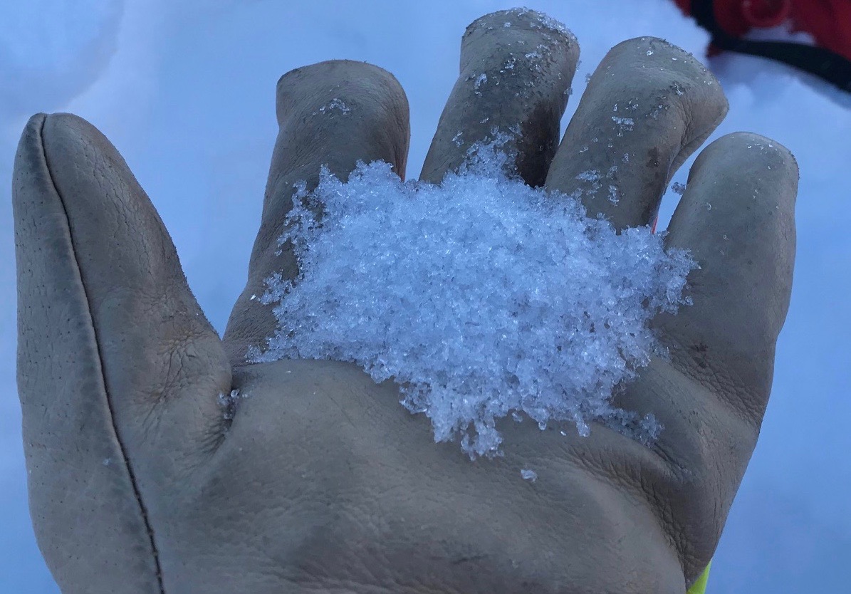
UPDATE 12:00 pm, January 27th. There is 10″ of light new snow in the Turnagain Pass parking lot. More snow has fallen than expected with the forecast this morning and winds are gusting into the 30s on Sunburst. The avalanche danger has increased to MODERATE at all elevations. Human triggered avalanches are possible. Watch for new wind slabs in the Alpine and soft storm slabs at lower elevations.


Special Announcements

Alaskans! Help us reach $20,000 in 2020 for Chugach Avy’s 20th anniversary next winter. Pick.Click.Give. some or all of your PFD to Friends of the Chugach National Forest Avalanche Info Center. Your donation pre-pays your annual membership AND guarantees good snow karma for winter 2020/21. Thanks, Friends!  Pick.Click.Give. link: for Friends of the Chugach National Forest Avalanche Information Center.

Mon, January 27th, 2020
Alpine
Above 2,500'
2 - Moderate
Avalanche risk
Treeline
1,000'-2,500'
2 - Moderate
Avalanche risk
Below Treeline
Below 1,000'
2 - Moderate
Avalanche risk
0 - No Rating
1 - Low
2 - Moderate
3 - Considerable
4 - High
5 - Extreme
Avalanche risk Avalanche risk Avalanche risk Avalanche risk Avalanche risk
Travel Advice Generally safe avalanche conditions. Watch for unstable snow on isolated terrain features. Heightened avalanche conditions on specific terrain features. Evaluate snow and terrain carefully; identify features of concern. Dangerous avalanche conditions. Careful snowpack evaluation, cautious route-finding, and conservative decision-making essential. Very dangerous avalanche conditions. Travel in avalanche terrain not recommended. Extraordinarily dangerous avalanche conditions. Avoid all avalanche terrain.
Likelihood of Avalanches Natural and human-triggered avalanches unlikely. Natural avalanches unlikely; human-triggered avalanches possible. Natural avalanches possible; human-triggered avalanches likely. Natural avalanches likely; human-triggered avalanches very likely. Natural and human-triggered avalanches certain.
Avalanche Size and Distribution Small avalanches in isolated areas or extreme terrain. Small avalanches in specific areas; or large avalanches in isolated areas. Small avalanches in many areas; or large avalanches in specific areas; or very large avalanches in isolated areas. Large avalanches in many areas; or very large avalanches in specific areas. Very large avalanches in many areas.
Avalanche Problem 1
  • Dry Loose
    Dry Loose
  • Certain
    Very Likely
    Likely
    Possible
    Unlikely
    Likelihood
  • Historic (D4-5)
    Very Large (D3)
    Large (D2)
    Small (D1)
    Size
Dry Loose
Dry Loose avalanches are the release of dry unconsolidated snow and typically occur within layers of soft snow near the surface of the snowpack. These avalanches start at a point and entrain snow as they move downhill, forming a fan-shaped avalanche. Other names for loose-dry avalanches include point-release avalanches or sluffs.

Likelihood of Avalanches
Terms such as "unlikely", "likely", and "certain" are used to define the scale, with the chance of triggering or observing avalanches increasing as we move up the scale. For our purposes, "Unlikely" means that few avalanches could be triggered in avalanche terrain and natural avalanches are not expected. "Certain" means that humans will be able to trigger avalanches on many slopes, and natural avalanches are expected.

Size of Avalanches
Avalanche size is defined by the largest potential avalanche, or expected range of sizes related to the problem in question. Assigned size is a qualitative estimate based on the destructive classification system and requires specialists to estimate the harm avalanches may cause to hypothetical objects located in the avalanche track (AAA 2016, CAA 2014). Under this schema, "Small" avalanches are not large enough to bury humans and are relatively harmless unless they carry people over cliffs or through trees or rocks. Moving up the scale, avalanches become "Large" enough to bury, injure, or kill people. "Very Large" avalanches may bury or destroy vehicles or houses, and "Historic" avalanches are massive events capable of altering the landscape.

Signal Word Size (D scale) Simple Descriptor
Small 1 Unlikely to bury a person
Large 2 Can bury a person
Very Large 3 Can destroy a house
Historic 4 & 5 Can destroy part or all of a village
More info at Avalanche.org

Despite chilly temperatures over the weekend folks took advantage of the sunshine, soft snow and good stability. A few loose snow avalanches (sluffs) were reported in steep terrain and one observer noted their group kicking off very small, soft wind slabs yesterday in the Pastoral zone.  Loose snow avalanches in steep terrain will continue to be the predominant hazard to manage today. However, it is important to note that it is a day of transition as the weather pattern over the region shifts. A few inches of snow is forecast to fall and the winds might pick up a bit from the east/northeast. If you are out today watch for changing conditions. There is plenty of soft snow available to transport and the new snow today will be low density. If winds are strong enough small wind slabs may develop in steep Alpine terrain. It also worth remembering that there is weak snow on the surface and in the upper snowpack as a series of storms impact the region this week. As temperatures warm, snow falls and winds increase burying the weak snow, the recipe for larger avalanches may develop in the days to come.

Wind Slabs:  In addition to the potential for small wind slabs developing today in the core forecast area, the wind effect from last Thursday and Friday is more pronounced in Portage, Summit Lake and Seward. Today’s wind may also be more of an issue in these zones as well. If you a heading to any of these places be on the lookout for blowing snow and stiff snow in the Alpine. Stiff snow over soft snow can be an indication of wind slab issues. Watch for cracking or hollow feeling snow.

Cornices and Glide Cracks:  As always, limit exposure under glide cracks and give cornices a wide margin.

Very small skier triggered sluffs on Seattle Ridge, 1.26.20, Photo: Joe Kurtack and the Anchorage Nordic Ski Patrol.

A handful of facets (sugar snow) that is in the upper snowpack over the New Years Eve crust on Tenderfoot, 1.26.20. This weak snow could be an issue if more slab develops on top. Stay tuned!


Weather
Mon, January 27th, 2020

Yesterday: Skies were mostly clear until clouds slowly moved in later in the day. With the area inversion temperatures were in the single digits to just below zero F at upper elevations and were in the negative teens to negative 20Fs in the valleys. Winds were light and variable. Overnight temperatures increased slightly in the Alpine while valley bottoms remain below zero. Winds were light and northeasterly.

Today: Skies will be cloudy with light snow in the forecast today and tonight. Expected total accumulations by tomorrow morning of 4-8″. Winds will be easterly 5-10 mph with gusts into the teens. Temperatures will slowly rise into the single digits and low teens.

Tomorrow: Light snow continues tomorrow with a more significant pulse expected overnight into Wednesday. The timing and total amounts of snow are still a bit uncertain. Temperatures will be in the high teens to mid 20Fs and winds will be moderate and easterly.

PRECIPITATION 24-hour data (6am – 6am)

Temp Avg (F) Snow (in) Water (in) Snow Depth (in)
Center Ridge (1880′) -7 0 0 42
Summit Lake (1400′) -12 0 0 17
Alyeska Mid (1700′) -6 0 0 40

RIDGETOP 24-hour data (6am – 6am)

Temp Avg (F) Wind Dir Wind Avg (mph) Wind Gust (mph)
Sunburst (3812′) 4 variable 6 22
Seattle Ridge (2400′) -4 NE 2 17
Observations
Recent Observations for Turnagain Pass
Date Region Location
10/27/24 Turnagain Observation: Tincan
10/21/24 Turnagain Observation: Turnagain Pass Road Observation
10/19/24 Turnagain Observation: Tincan – Below Todds Run
10/18/24 Turnagain Observation: Taylor Pass
10/15/24 Turnagain Observation: Tincan Common
10/14/24 Turnagain Avalanche: Tincan
05/13/24 Turnagain Observation: Eddie’s, Sunburst, Seattle, Cornbiscuit, Pete’s South
05/13/24 Turnagain Observation: Turnagain Pass non-motorized side
05/12/24 Turnagain Observation: Warm up Bowl
05/07/24 Turnagain Observation: Turnagain Pass Wet Slabs
Riding Areas

The riding areas page has moved. Please click here & update your bookmarks.


Subscribe to Turnagain Pass
Avalanche Forecast by Email

This is a general backcountry avalanche advisory issued for Turnagain Arm with Turnagain Pass as the core advisory area. This advisory does not apply to highways, railroads or operating ski areas.