Turnagain Pass Avalanche Forecast
|
![]() ![]() |
Today the avalanche danger is LOW at all elevations. LOW danger does not mean NO danger. Loose snow avalanches (sluffs) remain possible to trigger, especially in steeper terrain. On steep sustained slopes, dry snow avalanches could entrain a significant amount of surface snow and run to valley bottoms. Normal caution is advised for other concerns including cornices, glide cracks and small isolated wind slabs.
PORTAGE VALLEY, SUMMIT LAKE, LOST LAKE: Areas east and south of Turnagain Pass have seen an increase in wind over the past two days. Small to large wind slab avalanches may be possible to find and trigger and Extra Caution is advised in these outlier areas.
Signal Word | Size (D scale) | Simple Descriptor |
Small | 1 | Unlikely to bury a person |
Large | 2 | Can bury a person |
Very Large | 3 | Can destroy a house |
Historic | 4 & 5 | Can destroy part or all of a village |
The loose surface snow has remained under mostly clear and cold skies since it fell on Monday. Today calls for more cold temperatures, calm winds and partly cloudy skies, so it’s unlikely the snow conditions will be an exception to the recent trend and loose snow sluffs remain a concern. Monday’s snow has had time to settle, but due to temperatures averaging around 0°F and nominal to calm winds, it hasn’t formed slab character.
Loose dry or “sluff” avalanches are predictable. We know in most places the surface is covered with loose snow, and as the slope angle increases, the ease to trigger sluff avalanches increase. Once this sluff is initiated it could quickly gain both volume and momentum. If you’re venturing into steep terrain, consider making a plan to manage your sluff – it could easily knock you off your feet and take you with it down the fall line. Remain mindful when in areas with rocky outcrops and cliffs. Because it’s our primary concern, consider reading through this article on sluff management.
Yesterday, observers watched riders trigger and effectively manage loose dry sluff avalanches in the steeper sections of Sunburst. 1.25.20 Photo: CNFAIC Archive
Wind Slab avalanches: The northwest outflow winds have been moving down Cook Inlet and for the most part, have spared the Turnagain Pass area. Because it’s prudent to stay sharp, feel for stiffer snow over softer snow and look for smooth pillowed drifts. This issue is mainly outside of our forecast zone, but as wind can do sudden and unexpected things, we need to be on the lookout for wind effect in any area we travel.
Locations suspect for wind slabs: Summit Lake, Johnson Pass, Bench Peak and all the way south to Seward. The Seward area saw significant wind over the past two days with some natural avalanche activity. Portage Valley and the Whittier areas. North of Girdwood in the Crow Pass region.
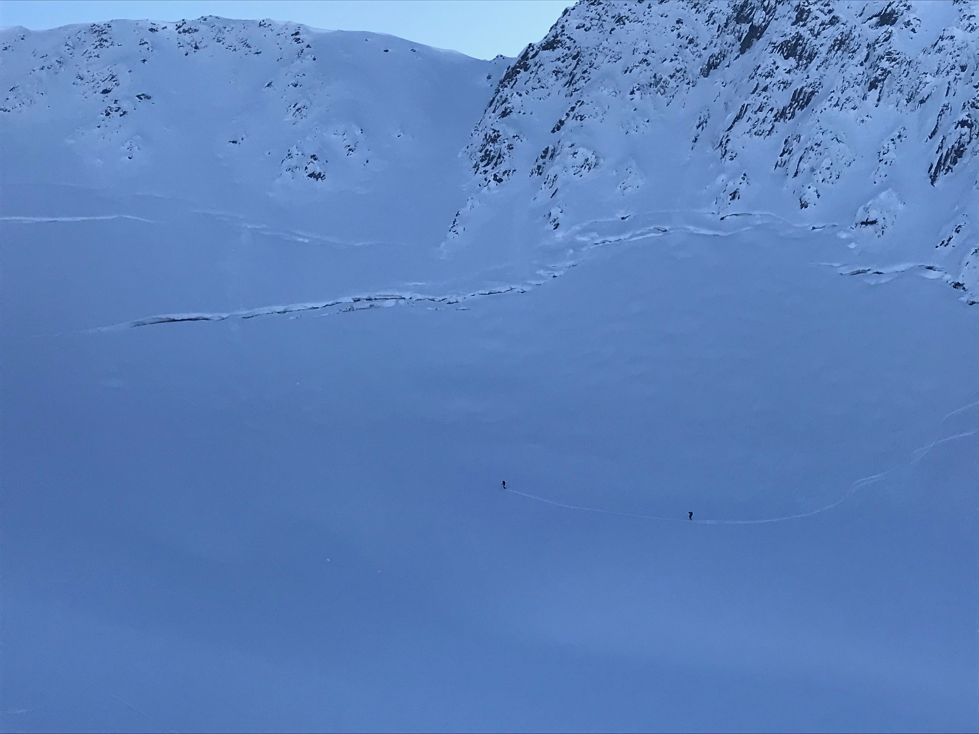
Cornices and Glide Cracks: As always, limit exposure under glide cracks and give cornices a wide margin.
These riders at Cornbuscuit are limiting exposure to the glide cracks above by moving swiftly while underneath them and maintaining spacing between one another. 1.25.20 . Photo: CNFAIC Archive
Yesterday: Mostly sunny skies with light ridgetop winds, 5-10mph from the northwest. Temperatures ranged from about -10°F to 5°F at all elevations.
Today: Partly sunny trending toward mostly cloudy this evening, with a high near 2°F. Winds will be out of the Northwest around 5 mph. There’s a chance of accumulating a trace of snow today, mainly after 9pm.
Tomorrow: Mostly cloudy with snow likely throughout the day accumulating 1-3″. Temperatures will see a high near 10°F and a low of 3°F. Winds will be around 5 mph out of the northwest shifting to east for the evening.
PRECIPITATION 24-hour data (6am – 6am)
Temp Avg (F) | Snow (in) | Water (in) | Snow Depth (in) | |
---|---|---|---|---|
Center Ridge (1880′) | -7 | 0 | 0 | 44 |
Summit Lake (1400′) | -11 | 0 | 0 | 17 |
Alyeska Mid (1700′) | -3 | 0 | 0 | 43 |
RIDGETOP 24-hour data (6am – 6am)
Temp Avg (F) | Wind Dir | Wind Avg (mph) | Wind Gust (mph) | |
---|---|---|---|---|
Sunburst (3812′) | -1 | W | 5 | 12 |
Seattle Ridge (2400′) | -7 | NNE | 5 | 11 |
Date | Region | Location | Observer |
---|---|---|---|
05/22/23 | Turnagain | Avalanche: Tincan | Nick D'Alessio |
05/12/23 | Turnagain | Avalanche: Tincan, Sunburst, Magnum, Cornbiscuit | Heather Thamm |
05/07/23 | Turnagain | Observation: Tincan – Bear Tracks | CNFAIC Staff |
05/05/23 | Turnagain | Observation: Seattle Ridge | AS/ WW Forecaster |
05/02/23 | Turnagain | Observation: Cornbiscuit | Schauer/ Sturgess Forecaster |
05/02/23 | Turnagain | Observation: Seward Hwy Turnagain Pass | Joel Curtis |
04/30/23 | Turnagain | Observation: Magnum | Ayla, Kit Crosby, Barton |
04/29/23 | Turnagain | Observation: Tincan | John Sykes |
04/28/23 | Turnagain | Avalanche: Taylor Pass/Pastoral | Schauer/ Creighton Forecaster |
04/28/23 | Turnagain | Avalanche: Tincan | Andy Moderow |
Status of riding areas across the Chugach NF is managed by the Glacier and Seward Ranger Districts, not avalanche center staff. Riding area information is posted as a public service to our users and updated based on snow depth and snow density to prevent resource damage at trailhead locations. Riding area questions contact: mailroom_r10_chugach@fs.fed.us
Area | Status | Weather & Riding Conditions |
---|---|---|
Glacier District |
Subscribe to Turnagain Pass
Avalanche Forecast by Email
This is a general backcountry avalanche advisory issued for Turnagain Arm with Turnagain Pass as the core advisory area. This advisory does not apply to highways, railroads or operating ski areas.